Texas Railroad History - Tower 2, Tower 105 and Tower 112 - San Antonio
Three Towers on
a Two-Mile Segment of the Galveston, Harrisburg & San Antonio Railway in San Antonio

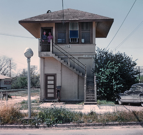
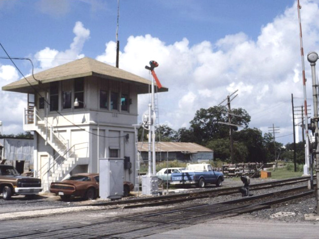
Above: Railroad executive John W. Barriger III snapped
this photo of Tower 112 (courtesy John W. Barriger III National Railroad
Library) from the rear platform of his business car in the late
1930s or early 1940s. Barriger's eastbound train has just passed over the
Roosevelt St. grade crossing. His camera faces west along the Southern Pacific
(SP) main line in south San Antonio, tracks originally built by the Galveston,
Harrisburg & San Antonio (GH&SA) Railway. By this time, GH&SA no longer
existed, having been merged (1934) into the Texas & New Orleans (T&NO) Railroad,
SP's operating company for Texas and Louisiana lines. Tower 112 had been erected
in 1919 by the San Antonio Belt & Terminal (SAB&T) Railway which was under a
99-year lease to the Missouri, Kansas & Texas (MK&T, "Katy") Railway. Katy tracks
(leased from SAB&T) are visible at far left
in Barriger's photo. Beyond the tower, those tracks angled across the Katy
bridge over the San Antonio River and then crossed
SP's main line at an acute angle at the west bank of the river. The
double diamond was just beyond the trackside railings in Barriger's photo
which mark the location of SP's bridge over the river (a bridge that had carried
its first train on March 26, 1881.) Tower 2 was about a half mile
farther west, but it had been razed
perhaps ten years before Barriger's photo was taken.

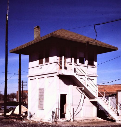
Above: Barriger took this photo of Tower 105 perhaps
two
or
three
minutes before he took his photo of Tower 112. The two photos are
consecutive in the John W. Barriger III National Railroad Library numbering
system indicative of how Barriger had originally labeled them. Tower 105 was
about 1.75 miles west of Tower 112 at SP's crossing of the International - Great
Northern Railroad ("I-GN" in Barriger's day, but originally "I&GN" -- the "and"
had been dropped in the early 1920s.) Again, Barriger
faces west, his camera awakened by the sudden appearance of Tower 105 in the
southeast quadrant of the I-GN crossing. The northeast / southwest I-GN tracks pass behind the
tower from this view. The cross track in the foreground was a connection between
I-GN and Katy tracks back to the east that paralleled the
SP line on the north side all the way to the Tower 112 crossing. The Katy's Nogalitos Yard
(renamed Sloan Yard in 1943) was
near Tower 105, about a thousand feet east.
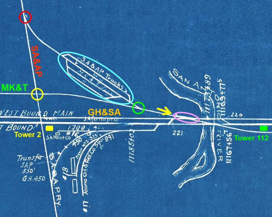
Above: This snippet from a larger 1918 track chart
(Stuart Schroeder collection) has been annotated to highlight the locations of
Tower 2, Tower 105 and Tower 112. Tower 2 controlled the GH&SA crossing of the
north / south San Antonio & Aransas Pass (SA&AP) Railway. Tower 2 was
built in 1902; no photos of it have been located, but Tower 3,
a crossing of the same two railroads, has been preserved. It is likely that the
towers shared a common design and appearance as they were both built by SP and
opened on the same day. When the Katy line was laid in 1917, its SA&AP crossing a hundred feet north of Tower 2 was incorporated into Tower 2's interlocking
plant.
Tower 2 was flanked by Tower 105, about 1.2 miles west, and Tower 112, just over
a half mile to the east. Tower 109 was also nearby
(off the map to the north) controlling the SA&AP crossing and the Katy's depot lead.
A 1901 state law granted the Railroad Commission of
Texas (RCT) authorization to regulate the safety requirements for crossings of
two or more railroads. At the time, all trains had to stop before crossing
another railroad at grade. This was obviously safe, but it was substantially
wasteful of time and fuel since most rail grade crossings are
unoccupied the vast majority of the time. RCT was expected to adopt mechanical interlocking technology
already in use in other states. An interlocking plant was a "fail safe" mechanical
(or electro-mechanical) device that
deconflicted access to the diamond by managing trackside signals and derail devices based
on control inputs from operators. Interlockers saved time and fuel by allowing
most trains to cross without stopping.
On June
5, 1902, RCT issued Circular No. 1597 ordering safety upgrades at two dozen
grade crossings to be completed (with RCT inspection) by June 30, 1903.
As plans were developed for interlocked crossings at each location, RCT chose
to number them, the first being Tower 1
at Bowie authorized for operation on April 17, 1902 (before the order was
issued!) Since the numbering system reflects the approximate chronology of tower
construction, the differences between the tower numbers for Tower 2, Tower 105
and Tower 112 are indicative of the gaps in the timeframes of their respective
commissioning dates. The first of these crossings to exist (in 1881) was the one
where Tower 105 was eventually built. It was a crossing of the International
& Great Northern (I&GN) Railroad and the Galveston, Harrisburg and San
Antonio (GH&SA) Railway in south San Antonio.
GH&SA had been chartered as
the Buffalo Bayou, Brazos and Colorado (BBB&C) Railway several years before the Civil
War to build west from Harrisburg, a community
located on Buffalo Bayou downstream from
Houston. After the War, the BBB&C was bankrupt and eventually came under the ownership of
Thomas Peirce (with the unusual 'ei' spelling of his last name), a wealthy
Boston businessman, lawyer and landowner. Peirce owned a large sugar cane plantation near
Arcola west of Harrisburg. Peirce had done legal
work for the BBB&C before the War so he was familiar with the railroad. He and
his investors petitioned the Legislature to modify the BBB&C's charter to change
the name to GH&SA and to authorize building to San Antonio. An unusual provision
in the revised charter allowed GH&SA to build as necessary to connect with any Pacific railroad. The
Legislature passed the charter revision law and Peirce began building west from
the BBB&C's end of track near Columbus.
 |
Left:
As Peirce built west in 1874, he claimed the marketing identity "Sunset
Route", which remains in common use today. This ad from the
Galveston Daily News of March
3, 1877 has GH&SA's train arriving San Antonio at 4:00 pm after
a 10:00 am arrival at Marion overnight from Houston. The odd note of "28 miles from Marion to
San Antonio" gives away the secret: the final segment was by stagecoach.
Marion was a tiny settlement near the west bank of the Guadalupe River
that was the end of track for GH&SA for several
months in the fall of 1876 and the winter of 1877. In October, 1876,
newspapers reported that a contract by Peirce to build a branch line from Marion
to New Braunfels had been let, but no tracks were ever laid.
Right: The
following day, March 4, 1877, the ad in the
Galveston Daily News changed to
highlight "All Rail Route". Marion was no longer mentioned, and
the arrival into San Antonio was 10:35 am the next morning after departure from Houston
at 8:45 pm. |
 |
Within a year of its arrival in San Antonio, GH&SA caught
the attention of Southern Pacific (SP) Chairman C. P. Huntington. Huntington was planning a southern
transcontinental rail line and GH&SA had much of what he needed in Texas, including the right
to build wherever necessary within Texas to
connect with any Pacific railroad. By the summer of 1880, a deal between Yoakum and Huntington was in place
to extend GH&SA tracks to El Paso. SP agreed to
provide all construction financing and deploy a survey crew to map the route.
Construction teams from SP's Southern Development Co. worked east from El Paso
beginning in June, 1881 while Peirce's own
construction crews built west from San Antonio. Both efforts were conducted under GH&SA's
charter. After a bit more than a year
and a half, the two construction crews met at the Pecos River on January 12, 1883 where
Huntington and Peirce drove a Silver Spike. As SP trains began operating
from California to Houston, SP leased GH&SA for several years and then acquired it.
 |
Left: GH&SA had begun building west from San Antonio toward El Paso about the
same time that I&GN had begun building south out of San Antonio to Laredo. By early
June, 1881, newspapers reported that I&GN tracks were more than 30 miles
south of San Antonio. But this item in the
Galveston Daily News of March 27, 1881 reports that the
first GH&SA train had crossed the San Antonio River, adjacent to the
future Tower 112 site and less than two miles from the future Tower 105
site. It ultimately did not matter which railroad reached the future Tower
105 crossing first. By the time the tower was built, RCT regulations
required the railroads to split the capital cost evenly because the crossing existed prior to
the 1901 law that allowed RCT to mandate interlocking plants. At
post-1901 crossings, the second railroad funded the capital expense of
the tower and interlocking plant. |
I&GN's entry into San Antonio had been delayed
by financial issues. The railroad had been created from the merger of the
International Railroad and the Houston & Great Northern Railroad, approved by
the Legislature in 1875. From the two railroads' junction point at
Palestine, track construction had finally reached
Austin on December 16, 1876. The final leg of construction from
Hearne had
stretched the company's finances to the breaking point, so it badly needed
operating revenue with which to pay expenses and bond interest. On April 1,
1878, the company was forced into receivership and then sold at foreclosure on
November 1, 1879 to buyers who formed a new I&GN company under the original
charter and management team. Construction restarted south from Austin to San
Antonio via San Marcos and
New Braunfels with a contract issued to the New Jersey Contracting Company
on May 31, 1880. The tracks arrived in San Antonio on February 16, 1881, and
work began on the Laredo extension soon thereafter. By this time, I&GN had
come under the control of rail baron Jay Gould who was aggressively expanding
his reach in Texas. Gould was trying to build Texas & Pacific (T&P)
tracks into El Paso (from Fort Worth) before SP
reached El Paso from California. Since Huntington's move to enlist GH&SA as
part of a southern transcontinental route effectively preempted the T&P's
Federal charter to build between Texarkana and San
Diego, Gould worked out a truce with Huntington to share GH&SA's track into
El Paso from Sierra Blanca. Meanwhile, Gould's I&GN extension to Laredo was
completed on December 15, 1881.
Shortly thereafter, another railroad built through San Antonio and crossed GH&SA tracks south of downtown, the future site of Tower 2. The San Antonio
and Aransas Pass (SA&AP) Railway was chartered in 1884 by Uriah Lott to
build between San Antonio and Corpus Christi. From
San Antonio, SA&AP built northwest to Kerrville in 1887, and then soon expanded into other areas of
south and central Texas, reaching Houston in 1888 and
Waco in 1891. In 1886, Lott hired a young man
to be his Chief Clerk. Benjamin Franklin Yoakum, age 27, was a native Texan who had gotten his start
in railroading on an I&GN survey gang. Under Lott's tutelage, Yoakum quickly moved
up to become SA&AP Traffic Manager. His hard work was rewarded when he became the namesake of a new town
founded by SA&AP, Yoakum, Texas,
which would host the railroad's maintenance shops. By January, 1888, Yoakum was issuing news releases
under the title General Manager. By the summer of 1890, Yoakum had yet
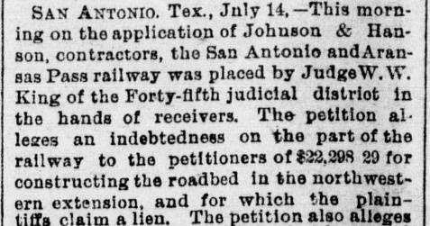
another title with SA&AP -- Receiver. The railroad was bankrupt.
|
Right: (Galveston Daily News,
July 15, 1890) Labor strikes and rapid branch line construction overextended SA&AP. A lawsuit filed by its
Waco branch contractor on July 15, 1890 forced it into receivership. Within a few
hours, Judge W. W. King had already named Yoakum as one of
the two Receivers. The other was J. S. MacNamara of I&GN. When Judge King
ran for reelection in San Antonio that November, there
were editorials and letters to newspapers claiming that Yoakum was active "in securing the election of his
man as judge." |
 |
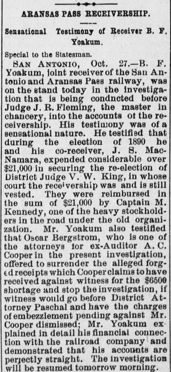
 |
 |
Yoakum did not have
an easy time as Receiver, though many problems were self-inflicted. The
claim that he was raising funds to help Judge King's reelection turned
out to be true (and Judge King won his race.) The two Receivers had
provided $21,000 to help Judge King's campaign, but Yoakum testified
that it was at the direction of Mifflin Kenedy, SA&AP's largest
stockholder, who reimbursed them.
A. C. Cooper, a former SA&AP
auditor under indictment for embezzlement alleged that Yoakum had taken
$6,500 from SA&AP's accounts for personal benefit. But Yoakum had been
out of town on the date he supposedly signed the receipts offered up by
Cooper's attorney as evidence of guilt. It was a ruse, a blackmail
attempt to force Yoakum's help in getting the indictment dismissed.
There were also claims that Yoakum was an investor in the company
supplying stone for new jetties at Galveston.
To help the company, Yoakum purportedly offered a very low price for SA&AP to haul the stone
to Galveston. Yoakum defended the price, saying it had
universal support among SA&AP management.
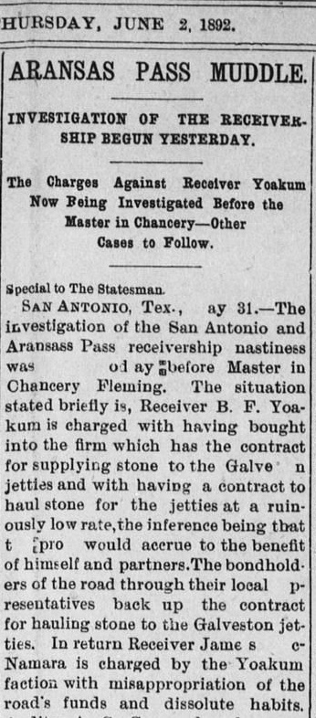
Judge King assigned Judge J. R. Fleming to act as Master in Chancery
under the Court's authority. Judge Fleming was to evaluate the
charges against Yoakum and review SA&AP's financial transactions.
On October 29, 1892, Judge Fleming released his report which confirmed
that Yoakum had been an investor in the jetty company. The report also
affirmed that SA&AP's books were good, finding no issue with any of
Yoakum's transactions as Receiver. The
receivership had effectively ended five months earlier when the bondholders'
committee had agreed to pay all outstanding debts. Judge King had kept
the receivership proceeding in place only because Judge Fleming needed
to retain the legal authority to complete his investigation.
Austin Weekly
Statesman left, June 2, 1892
and right, November 3,
1892
Above:
The Galveston Daily News of
June 16, 1892 reported the effective (but not legal) end of SA&AP's
receivership. |
 |
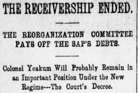
Yoakum resigned his
Receiver position shortly after the Reorganization Committee had effectively
ended the receivership by agreeing to pay
off all of SA&AP's debts. The
El Paso International Daily Times of July 9,
1892 reported that D. B. Robinson, the new President of SA&AP, had "...issued
an official order appointing B. F. Yoakum, ex-receiver, to the office of manager
of the system." Yoakum had no remaining duties as Receiver, hence he had
elected to resume his career as SA&AP General Manager. Judge King,
however, had not dismissed the receivership (and wouldn't do so until November
10, 1892.) Legally, Yoakum needed Judge King's permission to resign, but the
judge chose instead to terminate Yoakum formally from his Receiver position
based on Judge
Fleming's report. The termination in lieu of resignation might
have been a black mark against Yoakum, but it certainly had no effect on his
career.
Speculation by the Galveston Daily News that Yoakum would "Probably Remain in an
Important Position" with SA&AP was true, but only for a few
months. During
the receivership, SP had begun acquiring SA&AP stock with the intent of taking
it over when the receivership ended. In his reference tome on Texas
railroading, A History of the Texas Railroads
(1941, St. Clair Publishing), author S. G. Reed explains how SP chose to
proceed...
"A plan
was proposed by him [Mifflin Kenedy] whereby his interests were
protected, the Southern Pacific securing the bulk of the stock and guaranteeing
the interest on new bonds. This was approved by the Receivers and by the Court.
It avoided reorganization and re-chartering. On June 16, 1892, the Receivership
was terminated and the property turned over to the new owners."
As explained above, the receivership remained legally
pending in Judge King's court so that Judge Fleming's legal authority to investigate
the charges against Yoakum and others remained intact. Reed continues...
"The new
owners did not undertake to operate the property as part of the Southern
Pacific, but they selected as officers mostly Southern Pacific men. ... It is
surprising that neither the Railroad Commission of Texas nor the Attorney
General took cognizance of this control of the S. A. & A. P. by a parallel and
competing line at the time."
The accepted theory was that
RCT was more concerned with seeing that railroads were properly financed
and functioning with good service. Railroad competition was less
important, even though it was a requirement of the Texas Constitution.
To avoid any controversy, Huntington was very careful
in how he proceeded to effect control of SA&AP. Statements
attributed to him implying that a purchase of SA&AP was in work were quickly
retracted.
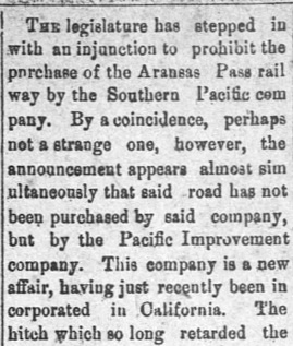
SP could not buy SA&AP outright without permission
from the Legislature, which would universally oppose the
idea. Instead, the
Pacific Improvement Company (PIC) made the purchase. PIC was the
holding company through which the Big Four of Transcontinental
Railroad fame (Leland Stanford, Mark Hopkins, Charles Crocker and C. P.
Huntington) owned Southern Pacific and various other assets,
particularly real estate.
Right: Brownsville Daily
Herald, February 21, 1893. The claim that "they have
manufactured a new company" was inaccurate; PIC had existed since
1878.
SA&AP became owned by PIC, but it was effectively run by
SP for the next ten years. RCT, the Texas Attorney General and the Legislature
each lost interest in pursuing the matter any further once it was
determined that SA&AP was legally independent of SP. |
 |
 |
Legal or not, SP had gained effective control of SA&AP, so it was
time for Yoakum to leave. His next stop was the Gulf, Colorado & Santa Fe (GC&SF) Railway
based in Galveston. The April 18, 1893 edition of the
Galveston Daily News reported "Yesterday morning Mr. B. F. Yoakum
assumed the position of general manager of the Gulf, Colorado and Santa Fe. He
was busy all day conferring with the heads of various departments." The
GC&SF had been acquired in 1887 by the much larger Atchison, Topeka and Santa Fe
Railway based in Chicago. Although Yoakum was a Vice President of the GC&SF, he
was looking for a larger opportunity. When a promotion with Santa Fe to Chicago
did not materialize, Yoakum moved again, in 1897, becoming Vice President and General
Manager of the newly independent St. Louis and San Francisco ("Frisco") Railway
based in St. Louis (it had been owned by Santa Fe, but both railroads went into
receivership during the
Panic of 1893.)
In 1900, Yoakum became President of the Frisco, and in 1903,
Chairman of its Board of Directors; he also became effectively the CEO of the
Chicago, Rock Island & Pacific Railroad as the two railroads moved toward a
long term relationship. With both Frisco and Rock Island having tracks in
north Texas, Yoakum decided to take on SP by building a coastal track network between New Orleans
and the Lower Rio Grande Valley centered in Houston. Yoakum called it
the Gulf Coast Lines (GCL), a marketing term for a collection of railroads to be built or
bought, each independently owned by
a syndicate run by the St. Louis Trust Co. The GCL railroads were managed by Yoakum and his Frisco executives.
Yoakum began by chartering the St. Louis, Brownsville and Mexico (SLB&M) Railway, the
first of the GCL railroads, and he hired his former boss Uriah Lott to run it.
SLB&M construction between Brownsville and Houston
began in August, 1903 starting south from Robstown
where construction materials could be shipped on the Texas Mexican (TM) Railway.
SP had observed the Valley's booming agricultural production and decided that
SA&AP should build there to counter Yoakum's move. The bonds SA&AP
issued to raise
funds for Valley construction were backed by an interest guarantee from SP as
required by the agreement ten years earlier when SA&AP came out of receivership.
SA&AP's bond issue was public information, and it immediately alarmed Yoakum.
SA&AP might reach the Valley before he did since it
already had tracks at Alice, a little over 100 miles from
Edinburg. In early 1903, perhaps on its own accord
or perhaps because of a tip from Yoakum, RCT began investigating a rumor that SP
unlawfully held controlling stock ownership of SA&AP. This did not
prevent SA&AP's construction south from Alice, which began in September, 1903.
It reached Falfurrias, only 67 miles from the Valley, on June 1, 1904. The
construction would proceed no further.
It was no secret
that SA&AP management was populated by "SP men" and it was public
knowledge that SP CEO C. P. Huntington had been a 25%
owner of PIC, the SA&AP's 80% majority owner; Mifflin Kenedy's heirs
owned the other 20%. (Kenedy died in 1895, Huntington in 1900.) At some point, the stock certificates held by PIC
had been secretly transferred to an individual acting on behalf of SP.
RCT's Auditor had no evidence of SP ownership of SA&AP stock, but he
knew that SP had provided a list of all of its stock holdings to the
Kentucky Railroad Commission (KRC) as part of the computation of Kentucky's franchise tax bill to SP
(Texas did not levy a franchise tax until 1907.) KRC provided RCT with
SP's asset list showing that SP owned 80% of SA&AP's stock. A public
hearing was held by RCT on April 27, 1903 during which SP and SA&AP
attorneys admitted the unlawful ownership. They also
agreed to consent to any RCT penalty resolving the issue so long as it did not require forfeiture of SA&AP's
Texas railroad charter.
On May 13, 1903, the Commissioners met
privately to decide how to proceed. They ultimately issued an order on
July 3, 1903 that had two critical requirements: SA&AP was required to
cancel and destroy $1.7 million in unsold SP-backed construction bonds,
and SA&AP was required to reduce its stock capitalization from $5
million to $1 million, canceling all of the stock owned by SP. RCT
subsequently allowed SA&AP to sell the bonds instead of destroying them
in exchange for SA&AP's agreement to build from Alice all the way to Brownsville.
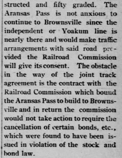
Right: By the spring
of 1904, SA&AP's interest in building to Brownsville had waned, no doubt
because the "Yoakum line is nearly there." RCT relented and allowed SA&AP to defer its Brownsville obligation.
A week after this news item was reported, SA&AP stopped construction at
Falfurrias.
(Brownsville Daily Herald, May 24,
1904) |
 |
|
S. G. Reed explained the
prevailing theory of why SA&AP's extension to the Valley ended abruptly at
Falfurrias:
"The project was dropped, in June,
1904, for lack of funds and also to quiet the Railroad Commission. The reason
officially assigned for discontinuing work was that there was not enough traffic
in the Valley to support two lines, but another reason was surmised and may have
been controlling, which was that [E. H.] Harriman, who then controlled the S.
P., and Yoakum had effected a mutually satisfactory agreement for preferential
routing of traffic between their respective systems. It is known that some such
agreement was effected about that time and it continued for many years, but that
it involved the abandonment by the S. A. & A. P. of the Valley extension is only
a surmise."
While SA&AP was stalled at Falfurrias, Lott completed
the SLB&M south from Robstown
to Harlingen and Brownsville in 1904, and then
built north to
Algoa. In the spring of 1908, Yoakum negotiated a Santa Fe connection into Houston
from Algoa. The Houston - Brownsville main line gave Yoakum exclusive control of Valley traffic for nearly
two decades. Unquestionably, his success with the SLB&M was a direct result of
RCT's investigation into SP and SA&AP. That the probe happened ten years after
SA&AP had emerged from receivership (with the blessing of Receiver Yoakum!)
seemed very suspicious, but SP did admit
illegal ownership. As the CEO of both the Rock Island and the Frisco, Yoakum was
well-connected in the realm of Midwest railroading which included Kentucky. If Yoakum's continuing close
friendships with RCT Commissioners gave him the opportunity to pass a tip, he
would undoubtedly have done so at the appropriate time to maximize
his advantage.
Soon after SA&AP had emerged
from receivership in the early 1890s, the Missouri,
Kansas & Texas (MK&T, "Katy") Railway had begun serving San Antonio via
rights on I&GN from San Marcos. When
the Katy needed a charter revision in 1899 to allow it to acquire an
east Texas railroad, a provision was inserted by lawmakers to require
the Katy to build its own line into San Antonio, presumably to create
better competition on north / south San Antonio traffic. The Katy
fulfilled its obligation on April 25, 1901, completing the 46 miles
from San Marcos to
San Antonio where it merged into GH&SA near
East Yard. The Katy had been using the I&GN
depot west of downtown, but its new tracks resulted in using SP's
passenger station east of downtown. SP then opened its new
Sunset
Station in San Antonio on January 31, 1903 and the Katy became a
tenant. Despite the new tracks, the Katy's freight operations
remained secondary. Being focused on passenger
service to points north (e.g. Fort Worth and Kansas City) and east
(Houston, via San Marcos and Smithville) while sharing other railroads'
terminal facilities had resulted in the Katy being viewed locally as a
second class railroad. The business community fully understood that the
Katy had laid tracks to San Antonio only because the charter law
required it.
In 1911, the Katy decided to rectify the situation.
It bought 25 acres from B. F. Yoakum,
land he had originally planned to use for a Frisco expansion into San
Antonio. A
group of Katy-backed investors then chartered the San Antonio Belt & Terminal
(SAB&T) Railway in 1912 to build a belt line railroad around San
Antonio along with new yards
and depot facilities for the Katy. The Katy sold the land to SAB&T
in 1913 and then leased SAB&T for 99 years in 1916. |
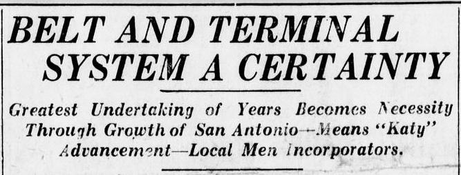
Above:
(San Antonio Express, May 2, 1912)
This headline heralded a lengthy article about SAB&T. It would
branch off the Katy's main line in northeast San Antonio (about a
half-mile shy of East Yard) and proceed due south for two miles where it
would begin a sweeping curve to the west along Westfall Ave. About two
miles from the start of the curve, SAB&T tracks would become parallel to
(and south of) SP's main line, heading due west just over a mile south
of downtown. To reach the planned Katy depot on the south edge of downtown, SAB&T would need to cross
to the north side of SP's tracks. |
The San Antonio City Council helped where it could by
adopting ordinances granting SAB&T use of city streets and other city
property. One particularly contentious council meeting was held on October 1,
1914. As reported the following day in the San Antonio
Express, the council completed a "second reading" of the franchise
ordinance (a third reading was required before adoption.) Citizen speakers
complained about a variety of topics, most especially that granting the
franchise would damage parts of San Antonio, resulting in reduced property
values and thus lower taxes to the city. Residents of the Highland Park
neighborhood near Westfall Ave. were particularly upset. Another theme -- why
wasn't Katy management acknowledging its role? One speaker commented... "If
this is really the Missouri, Kansas and Texas of Texas, they should come openly
before the city and above board say so and assume the damage inflicted on
citizens of this city." On May 13, 1915, SAB&T finally got its franchise from the city to enable it to build on
particular streets and property so long as construction commenced within one year. SAB&T would need to cross to the north side of SP's
tracks near the San Antonio River, about 3,000 feet east of Tower 2. The railroads
agreed that this location would become the site of the River Crossing Interlocker.
RCT commissioned the interlocker as Tower 112 on December 30, 1919, a 39-function mechanical plant
just over a half mile east of Tower 2. Although RCT's official list of interlockers recorded it as a
crossing of SAB&T and GH&SA, it was in all respects a Katy / SP crossing.
Tower 112 had a concrete architecture characteristic of other Texas
interlocking towers designed by the
Katy (e.g. Tower 53, Tower
64, Tower 93.) In particular, Tower 112 is
reported to have been identical to Tower 109 which
had been built about a year earlier by SAB&T farther west, where the track
into the Katy's new passenger and freight terminal crossed SA&AP's line. Under regulations established by RCT, the capital cost of
Tower 112's building and interlocking system had to be borne by SAB&T
because the crossing did not exist prior to 1901 when the interlocker law took
effect.
Recurring operations and maintenance costs would be split based on the ratio of the interlocker
functions attributed to each railroad compared to the total function count
(the precise split for Tower 112 has not
been determined.) RCT documentation reports that Tower 112 was staffed by SAB&T,
but these were undoubtedly Katy employees. [SP eventually took over the staffing
responsibility for Tower 112, but the timeframe and reason for doing so has not been
determined -- it was at least a decade prior to the closure of the tower in
1987.]

Above: This photo of Tower
112 was taken by John W. Barriger III facing east from
the rear platform of his business car sometime in the 1930s. His car has just passed over the
Katy's San Antonio River bridge and
immediately crossed SP's double track. It will continue west to enter Nogalitos
Yard
where it will turn north toward the Katy's passenger and freight terminal. In
the distance, a westbound SP train sits just shy of
the Roosevelt St. grade crossing waiting for Barriger's train to clear the
diamond. If the switch in the foreground at left remains unchanged, the SP train
will curve northwest to connect into the former SA&AP tracks (which had become owned by SP
in the mid 1920s) and proceed north to Kerrville. (John W. Barriger III National
Railroad Library)
 |
Left: This
annotated snippet from a 1918 track chart (Stuart Schroeder
collection) shows a yellow arrow depicting Barriger's view
east-southeast along the Katy tracks. The pink oval shows Barriger's
foreground view, but the map does not show the track parallel to the one
Barriger's train is on. Instead, it shows a
switch (green circle) off the Katy onto the connecting track toward the
SA&AP line. The track topology likely had changed by the time of
Barriger's photo.
When GH&SA's line was
double-tracked through south San Antonio, the SAB&T (Katy) line was also being built, both
c.1917. SA&AP's main line gained two additional crossing diamonds: one
for the Katy (yellow circle) and another adjacent to Tower 2 for the second GH&SA main track.
The RCT annual report published at the end of 1923 began listing Tower 2
with 19 functions, accounting for the signals and derails
required for the two additional diamonds.
Between the Katy
switch (green
circle) and the SA&AP switch (red circle), SA&AP is shown
having two yard tracks (blue oval). The other interior siding track
faintly shows "MK&T" and the track below it shows "ditto" marks. The
presence of two small arrows at both ends of "SA&AP Tracks" confirms
its ownership of the main track of this connector. A 1915 Katy track
chart shows this diagonal connector at least two
years before SAB&T's line was built.
The track topology changed considerably
in this area over many years, particularly in more recent decades due to
mergers and consolidations. For example, sometime between 1986 and 1995 the Katy tracks were rerouted
to share SP's bridge over the San Antonio River, eliminating the Katy
bridge. |
The SA&AP / GH&SA crossing in south San Antonio had existed since 1884, long
before the 1901 interlocker law. Shortly after the law became effective, RCT
ordered SA&AP and GH&SA to install an interlocking plant; RCT identified it
as Tower 2. With construction completed, RCT authorized operations to commence on October 9, 1902.
It was a 2-story building with a 10-function / 10-lever mechanical interlocker
that opened on the same day
as Tower 3 in Flatonia where the same two railroads crossed. Both were owned by
SP although SP's controlling ownership of SA&AP was a closely held secret
at the time because it had not been authorized by the
Legislature.
As a pre-1901 crossing, RCT regulations required the capital
expenses for the tower and interlocking plant to be split evenly between
the railroads. Recurring costs for operation and maintenance were split based on
the percentage of the interlocker's functions directly attributable to each
railroad. Tower 2 only had ten functions, two less than the typical minimum
crossing which would normally consist of a distant signal, home signal and
derail in each of the four directions. Interlocker documentation for Tower 2 obtained from SP by Carl Codney provides
considerable detail about the evolution of Tower 2 and the impact SAB&T
construction had
on the tower's responsibilities. SP used an internal "Drawing D-205" form titled Statement Showing
Levers, Functions and Division of Expense at Interlocking Plant as a
way of summarizing information about each of the interlocking towers at
which SP had track ownership. Two such forms are in Carl's collection for Tower
2.
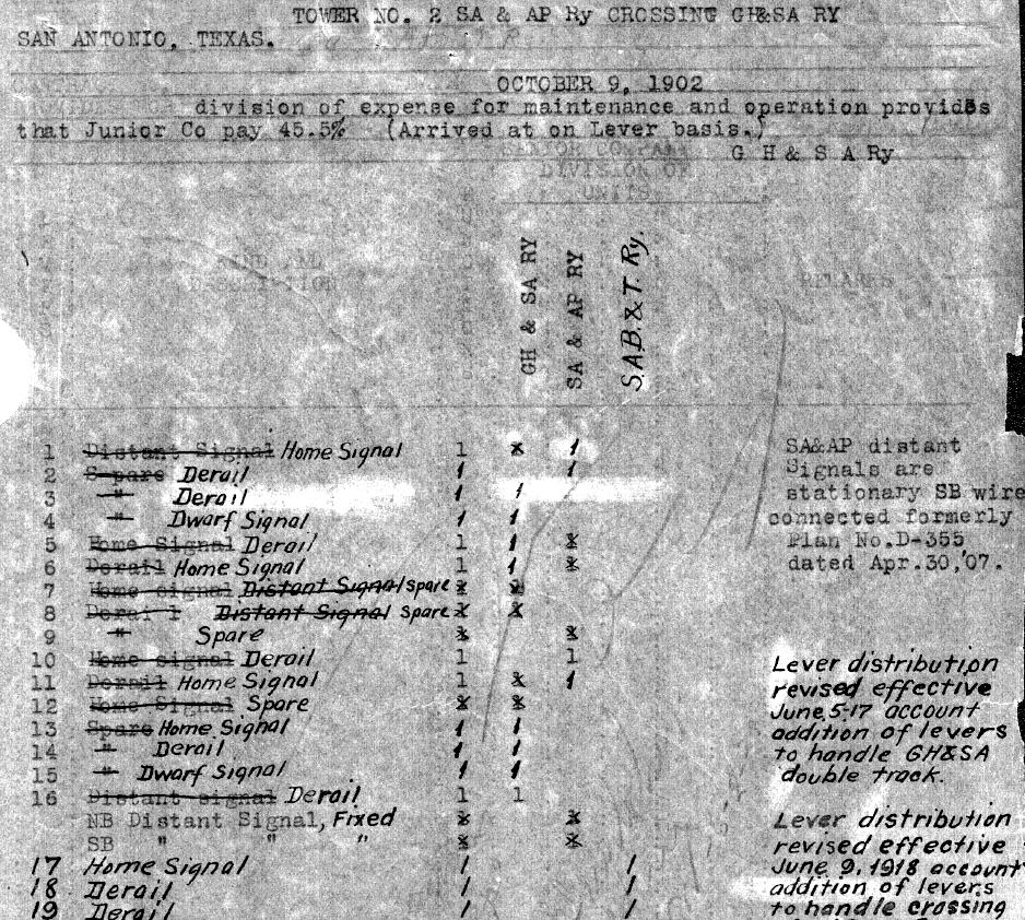
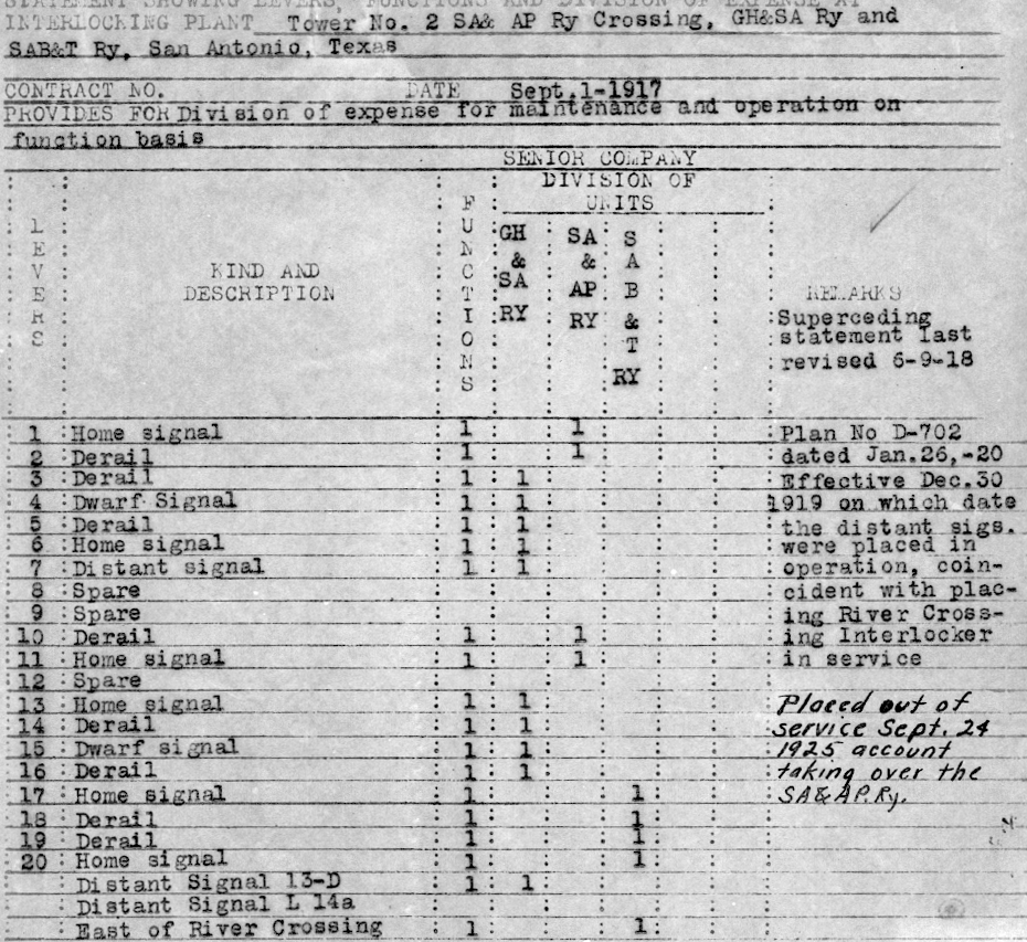
Above: These two D-205 documents dated October 9, 1902 (left)
and September 1, 1917 (right)
were produced by SP for Tower 2
(Carl Codney collection; click each image
to see the full drawing.) The 1902 drawing conveys the original design for Tower
2 and was amended by hand many times over the years. The original expense
sharing is listed as 54.5% GH&SA, 45.5% SA&AP. The drawing shows that the
interlocker was planned with twelve functions which included distant signals
in each direction on SA&AP's tracks. The expense ratios suggest a total of eleven functions
-- GH&SA with six and SA&AP with five. By the time the interlocker was placed in service, at
least one fixed sign had replaced a SA&AP distant signal, probably northbound since
such trains would always stop at (or pass slowly through) the SA&AP yard. This
reduced the function count to 10 as reported by RCT in the interlocker summary
table it published on December 31, 1903.
At the bottom of the 1902
drawing, GH&SA is identified as responsible for tower maintenance, but SA&AP is listed as responsible for tower operations. This
split was unusual for manned towers; typically one railroad staffed all maintainance and operations. In this case, it was effectively the same railroad because SA&AP had been presumed to be under SP control for the previous ten years (and as RCT found
out in 1903, it actually was!) A notation on
the drawing shows that the plan was revised on April 30, 1907 but this may have
reflected an "as installed" update to the detailed documentation because it did
not appear to affect the interlocker function allocations. Another notation dated June 5,
1917 states that the lever distribution was revised to "handle GH&SA double
track."
Shortly thereafter, the 1917 drawing was generated. It
accounted for changes incorporated for the SAB&T tracks, producing an expense
sharing of 52.63% GH&SA, 21.05% SA&AP and 26.32% SAB&T. Staffing was
no longer split; GH&SA
handled all operations and maintenance. A
typewritten notation states that the drawing was updated January 26, 1920 to
reflect the configuration that was... "Effective December 30, 1919 on which
date the distant sigs. were placed in operation, coincident with placing River
Crossing Interlocker in service." The only other notation is handwritten...
"Placed out of service Sept. 24, 1925 account taking over the S.A.&A.P. Ry."
Tower 2's closure was not listed in RCT's annual interlocker report until the
end of 1926. The fate of the tower structure is unknown.
In the Transportation Act of 1920, Congress directed the Interstate Commerce
Commission (ICC) to promote and plan consolidation of U.S. railroads into a
limited number of "systems". The ICC responded by hiring economist William Z.
Ripley to develop a plan. The so-called Ripley Plan proposed that SP head one
of these systems and that SA&AP become part of it. Although the Ripley
Plan was never formally implemented, the authority of the ICC to regulate
interstate
railroads granted by the Act overrode the power of state railroad commissions. On December 6, 1924, SP
applied to the ICC for permission to obtain control of SA&AP. The State of Texas opposed the move, but was overruled by the ICC, which
granted SP's application. In March, 1925, SA&AP was acquired (legally!) by SP and
leased to GH&SA. As noted above, Tower 2 was then closed (with RCT
permission) in September
and its remaining controls were transferred to Tower 112. Most likely, SP
convinced RCT that the operation on the SA&AP line would change
substantially by eliminating
direct north / south crossings over the GH&SA main track. Instead, freight movements on the
SA&AP tracks in either direction would originate or terminate at SP's East Yard.
The SA&AP passenger depot was closed and all passenger traffic on the former
SA&AP main line would originate or terminate at Sunset Station. As both East
Yard and Sunset Station were east of Tower 112, that tower would be handling the
traffic that previously engaged Tower 2.
In 1926, SP resumed
construction of the SA&AP line from Falfurrias into the Valley, arriving in
Edinburg in 1927 and immediately continuing east to Brownsville. This
ended the two-decade control of Valley traffic by the SLB&M which by then was owned by
the much larger Missouri Pacific (MP) system. Also in 1927, SP began consolidating its Texas railroads into a
single operation, the Texas & New Orleans (T&NO) Railroad. GH&SA and SA&AP
were both leased to the T&NO in 1927, and both were legally merged into
the T&NO in 1934. The T&NO lasted until 1961 when all of its assets were merged
into SP.
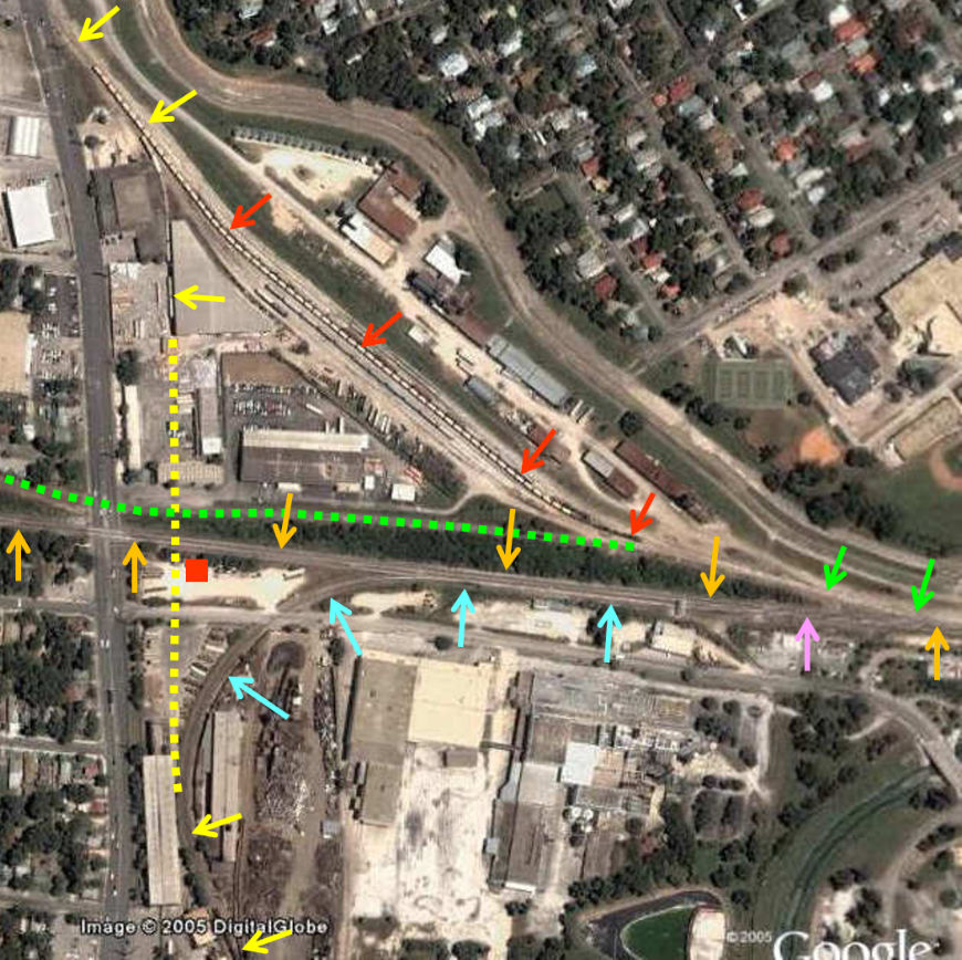 |
Left:
This 2005 Google Earth satellite image has been annotated to show the
evolution of track topology in the vicinity of the Tower 2 crossing.
Through 1925, the tower (red rectangle) sat in the southeast quadrant of
the crossing of GH&SA (orange arrows) and SA&AP (yellow arrows
and dashes.) The connector (red arrows) between GH&SA and SA&AP's northern
route existed at least by 1915. There were yard
tracks here (aerial imagery from 1955 shows about a dozen) but the
number likely varied over time as industries came and went
along the west bank of the San Antonio River. Here, a strand of railcars sits on a
short industry spur that appears to have been part of the original SA&AP
main line (yellow arrow above the yellow dashes.)
On the former
SA&AP main line, SP abandoned
the last 49 miles into Kerrville in 1970; the new end-of-track was Camp
Stanley. SP was merged into Union Pacific (UP) in 1996, and in 2000, UP abandoned
another 3.5 miles back to Leon Springs. The line was then further cut
back to
the Beckmann Quarry from which Yoakum had shipped stone for
Galveston's jetties. UP's track still ends there, 17 miles north of Tower
112. Alamo Gulf Coast Railroad serves the Quarry and interchanges with UP.
To the south, SP had abandoned the former SA&AP tracks between Elmendorf and
Sinton by 1995,
constituting a substantial majority of the original main line. UP
retains service to Mission Rail Park near Elmendorf, 16 rail-miles south
of the former Tower 2 crossing. The switch (pink arrow) for the
connecting track (blue arrows) between the main line and the route south
to Elmendorf is much farther east than might be expected from the
imagery, probably a result of switching onto a GH&SA siding instead of the main line
at the time the connector was built. It became part of the main line to
the south when the Tower 2 crossing was removed (yellow dashes.)
In 1988, the Katy was acquired by MP which had been owned by UP since
1982. To the east, the Katy main track was retained but it was merged onto
the former SP main line at Roosevelt St. From there west, the Katy
tracks (green dashes) that passed near the Tower 2 crossing were
abandoned, as was the Katy's Sloan Yard farther west. The Katy passenger depot
had closed in 1964. |

Above: Based on the numbering
system in the John W. Barriger National Railroad Library, this photo was taken
on an earlier trip past Tower 105 compared to the one at the top of this
page. Again, Barriger is facing west, but is much closer to the tower, having
snapped his camera just as his business car crossed the I-GN connecting track to
the Katy. There are very few differences in the two scenes, but the vehicle
parked across the tracks from the tower is not the same one. The building across from the tower
is a
maintenance shed, probably with the same paint scheme. A maintenance motorcar is
parked in front, and material is visible between the rails to aid in moving the
car on or off the rails. Myron Malone explains..."The
area between the rails is 'decked' similar to a wooden automobile crossing.
Looks like caliche rock, same material the white road in the background is made
of. The front axle is split in such a way as to allow the two front wheels to
spin independently. The back axle is solid. Lift handles slide out the back for
leverage and lifting. That is a very lightweight car. One man can handle it.
Probably a signal maintainer or code line maintainer's car. The car is so light
they put minimal effort into their set-on spot. There are factory skids on the
bottom of the car to assist in rough set-on points like this."
It seems odd that this GH&SA / I&GN intersection of two major railroads
was not one of the early crossings ordered
by RCT to be interlocked. The proximity of the I&GN yard and
passenger station just over a mile north of the Tower 105 crossing might have
justified I&GN trains operating slowly in the vicinity of the crossing anyway,
but why wouldn't SP want to avoid having its trains stop at the crossing? Its
passenger station and yard were on the east side of town, several miles away,
and its trains could otherwise have been operating at a decent track speed. A
1910 GH&SA timetable notes the existence of the I&GN crossing but says nothing
about it, not even in the Special Instructions which often contain references to
interlockings and gates. It's possible that the crossing was gated and normally
lined against I&GN, but the timetable doesn't say so. A gate would have
allowed SP trains to approach at restricted speed and continue without stopping
if the gate was not lined against them. Evidence from newspapers merely adds to
the mystery.
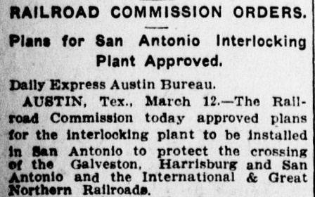 |
Left: As early as March 13, 1908, the
San Antonio Daily Express was
reporting that RCT had approved plans to interlock the GH&SA / I&GN
crossing. RCT usually assigned a tower number as soon as design-related
correspondence began to arrive, and plans for Tower 79
were evaluated at the same meeting (per Palestine
Daily Herald, March 14, 1908.) Tower 79 was commissioned in May,
1909. Shouldn't a similar number have been assigned for the GH&SA / I&GN
crossing, even if the tower commissioning date was delayed?
Right: In March, 1914,
RCT again prepared to review plans to interlock the GH&SA / I&GN
crossing. What happened to the 1908 approval? Did RCT fail to issue an
order and the railroads simply elected to wait? |
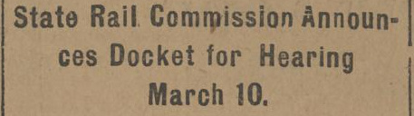
* * *
Galveston Tribune, March 4, 1914 |
 |
Left: RCT
issued an order on March 14, 1914 requiring the GH&SA / I&GN crossing
to be interlocked within nine months. Twenty-five months later, Tower
105 finally opened on April 29, 1916 with a 17-function mechanical
interlocking plant. The reason for the delay is unknown, and the
disposition of RCT's prior approval in 1908 remains undetermined. |
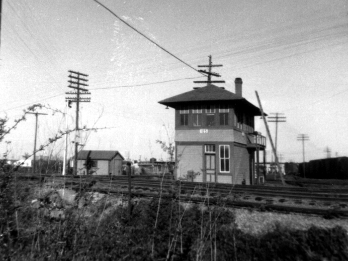 |
Left: This photo of
Tower 105 was taken in 1952 by Henry O'Connor (Tim O'Connor collection.)
The view looks northeast across the I-GN tracks from a position south of
the diamond (at far left.) Tower 105's
design follows the distinctive architecture of numerous towers built by
SP in Texas (e.g.
Tower 21, Tower 26,
Tower 32, etc.)
A. Tyrrell Kott
adds...
"Tower 105 was painted yellow and brown. This is the T&NO/SP
paint scheme. Note that the
moveable window sashes are white.
The tower has brown screens that obscure this fact, but
one window
is open and you can see the white sash."
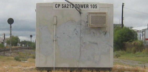
Below:
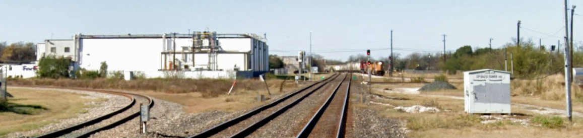
Based on historic aerial imagery, Tower 105 was closed in the 1966-1973
timeframe. By 2009, this equipment cabinet located on the north
side of the tracks was providing the Tower 105 functionality. (Jim King photo, 2009)
 |
By the end of 1930 when RCT published its final comprehensive list
of active interlockers, the function count at Tower 105 had grown to 36
functions. The sudden change from 17 to 36 functions was reported in RCT's
interlocker list published at the end of 1923. The large growth in the function
count is attributable to several factors, among them the Union Stock Yards
located immediately southeast of the crossing which grew as a destination for
shipping cattle by rail. Also, GH&SA's line became double tracked c.1917,
increasing the number of diamonds,
hence more signals and derails (the fact that there was no change in the
function count for Tower 105 reported by RCT after the known double tracking of
the SP line leads to the conclusion that at least some of the increase from 17
to 36 in 1923 was a documentation correction for cumulative function changes
that had occurred in the interim.) I&GN's line was double tracked through this
crossing at least by 1918 (per track chart at top of page), but whether this
occurred before or after Tower 105's construction in 1916 is undetermined.
Despite the presence of the Katy nearby, the Katy was never listed as a
participant in the cost-sharing for Tower 105, at least through the end of 1930.
This leads to the assumption that the Katy connector in the foreground
of Barriger's photo was owned by I-GN.
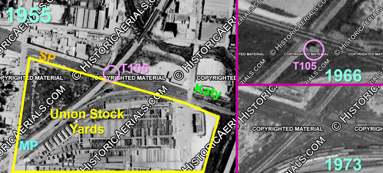
Above: As illustrated by this
1955 image (all images (c)historicaerials.com), the founders intentionally chose
the GH&SA / I&GN crossing for the location of the stockyards. The yards
opened in 1889, anticipating substantial numbers of cattle arriving by rail.
Sometime between 1966 (upper right) and 1973 (lower right), Tower 105 was
removed from the crossing; the fate of the tower building is undetermined. After the stockyards ceased handling cattle in April, 2001, the
land was repurposed for various light industry and residential uses.
I&GN had entered into
receivership in 1915, and this may have impacted the construction of Tower 105
since the two railroads had to share the capital cost equally. The receivership
ended in 1922 when I&GN was sold at foreclosure to new owners, becoming "I-GN" instead of
"I&GN". It had more than 1,100 miles of track in Texas, but its repeated
financial reorganizations made it a good target for takeover. The Frisco tried
to buy it in 1922 but the ICC refused to approve the sale. MP tried to buy I-GN in 1924 as a means of
gaining access to the Texas market, but again, the ICC nixed the sale. MP's
fallback strategy was to arrange for the New York, Texas & Mexico (NOT&M)
Railway to buy I-GN simply to keep it out of the hands of other
competitors. [The NOT&M had been one of the original GCL railroads, and the
Frisco had acquired it and the other GCL railroads from the St. Louis Trust Co.
in 1910. During the Frisco's
receivership in 1913, the GCL railroads had been separated from the Frisco by
the bankruptcy judge and the NOT&M had been re-chartered in Louisiana to become
the corporate parent of the GCL.] The sale of I-GN to the NOT&M was approved by the ICC in
June, 1924. MP was then allowed to buy the NOT&M on January 1, 1925 with
approval from the ICC, acquiring the target I-GN along with all of the GCL
railroads. MP and I-GN both went into a lengthy receivership in the 1930s, finally
emerging from it in 1956. At that time, I-GN was dissolved and its assets
merged into the newly reorganized MP.
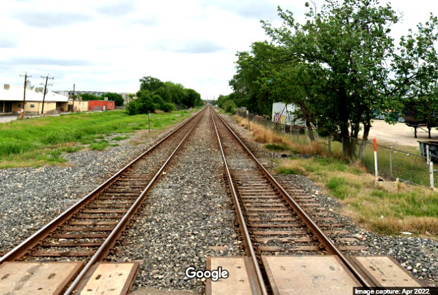
Above: From the South San
Marcos St. grade crossing, this January, 2022 Google Street View looks west down
UP's Sunset Route toward the Tower 105 crossing. There is only a single track on
the former MP line across the double-track Sunset Route, hence only two
diamonds. The southeast quadrant connector visible at left becomes a second
track going south to UP's Sosan Yard three miles distant. An eastbound UP train is taking the
northwest quadrant connector to go north on the former MP (I-GN) line. A slight
curve in the distance contributes to an
optical illusion that makes it appear as if the train is crossing over the north
track from the south track to reach the connector. The equipment cabinet at
right has replaced the one in the 2009 photo above.
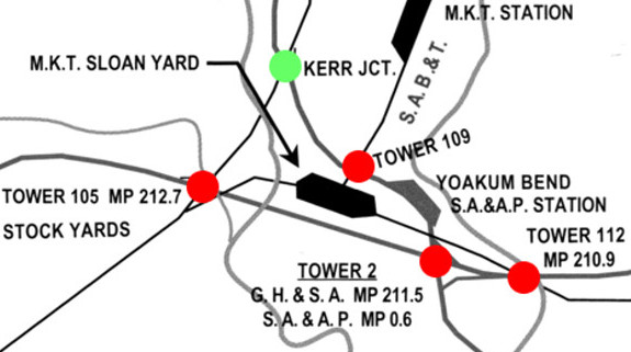 |
Left: This
image snippet is taken from a map produced by David W. Bernstein for his book
Southern Pacific's Eastern Lines 1946-1996
published in 2015 by the North Texas Chapter, National Railway
Historical Society. It has been annotated with red circles to highlight
the four numbered interlocking towers in south San Antonio (a fifth,
Tower 121, was on the northeast side of
town.)
The green
circle marks a crossing of SA&AP and I&GN that existed from
the late 1880s about a third of a
mile northwest of Tower 109. It is marked as Kerr Jct., but it was also
known as Apache Junction. The use of signals, if any, for this crossing
is undetermined and it was not included in RCT's numbering system
for interlockers. |
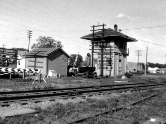
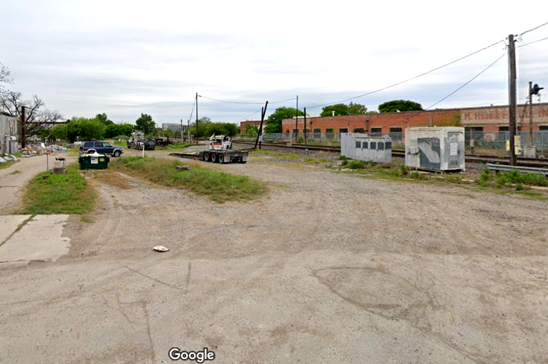
Above Left: Looking east along the UP tracks from Probandt St., Tower 2
sat approximately where the
trailer is located to the right of the tracks. Above
Right: In
this 1960 photo of Tower 112 by Roger Puta, the camera is facing west from
Roosevelt Ave. which formerly crossed both railroads at grade. That is no longer
the case; the SP grade crossing was removed and the street barricaded some time
after 1986. The Katy tracks
are visible to the south (left) of the tower. A utility pole beyond the trees at
right (above the car) marks SP's Sunset Route tracks on the north side of the
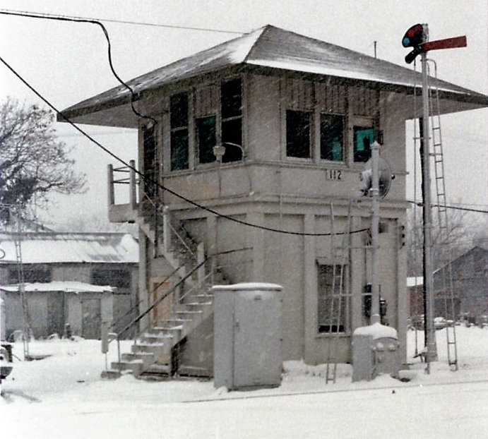
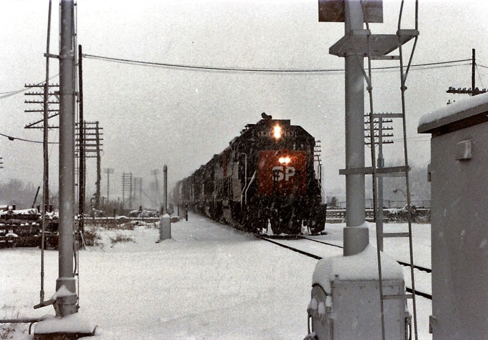
tower. Below: Stuart
Schroeder provides these two "snow photos" he took of, and from, Tower 112,
explaining..." I worked 2nd trick at Tower 112 on
January 11, 12 and 13, 1985 during the snowstorm..."
Above Left:
Henry O'Connor photo of Tower
112 (1952) from the collection of Tim O'Connor
Above Right: Tower 112 in 1986, from the collection of
Greg Johnson.
Observation of A. Tyrrell Kott
"This photo (above left) is looking northeast toward Tower 112. The MKT
line is in the foreground; the T&NO "Sunset Route" is in the background.
Note the searchlight signal and the black and white crossing gates for "old
Roosevelt Ave." which was the original alignment of Roosevelt Ave. before the
underpasses were built to the west of the photo. Tower 112 and
Tower 109 were absolutely identical concrete
structures."
Above Left: This photo of Tower 112 (Stuart L. Schroeder
collection) was taken on December 27, 1987. Stuart comments..."The tower was
soon to be demolished as the controls had been transferred to the Southern
Pacific Del Rio train dispatcher located at the SP depot on Commerce St."
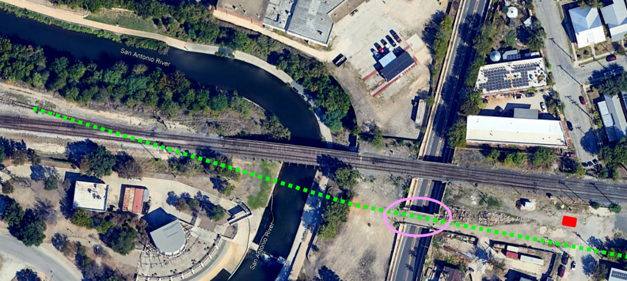
Above Right: This Google
Street View image from 2019 shows the site of Tower 112. The image was captured
from Roosevelt St. which now dead-ends at the UP tracks. The dirt roadway at far
left was the Katy right-of-way. Below:
This 2023 Google Earth view of the site of Tower 112 has been annotated to show
the location of the tower (red rectangle) and the path of the Katy tracks (green
dashes.) Note that the Katy bridge (pink oval) over the St. Mary's St.
underpass (built in 1937) remains intact.
Additional Observation of A. Tyrrell Kott
"There was a second crossing of the T&NO and
MKT near Tower 112 at an industry siding of the T&NO. This crossing was
located about one block east of S. Presa St., three
blocks east of Tower 112 itself. The T&NO siding ran due south
from the curve of the double track T&NO
and curved across the Katy; the crossing was controlled by the tower operator
(inside the interlocking limits of Tower 112). Today, this is just east of the alignment
of I-37 on the map. The industry was located one block north of Page Junior High
School along Berkshire Street (in the large open space on the map four blocks
south of the Katy and one block east of I-37). My mother used to teach at Page
Jr. High which was torn down in the early 1950's. I saw T&NO 0-6-0's switch the siding
in the early 1950's and Tom Balzen of Austin, who attended Page
Jr. High in the 1950's, did too. I spent a LOT of time there in the
early 1950's."
Researching Kott's description is hampered by the lack
of readily available historic aerial imagery prior to 1955. The key geographical element is that the crossing was "one block east of S. Presa St."
That correlates with 1955 imagery showing a T&NO spur clearly crossing the Katy to serve an
industry. The spur matches neither the
description of the T&NO spur as "due south" nor the location of the industry
as "one
block north" of Page Junior High, but some allowance must be made for hazy
details in recollections from many decades earlier.
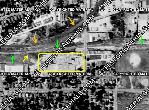
Above Left: This 1955 image
((c) historicaerials.com) has been annotated to show the industry that appears
to
have been the subject of Kott's description. The orange arrows mark the SP
tracks and the green arrows mark the Katy tracks. The yellow arrow
indicates the SP spur that crossed the Katy to serve the industry (yellow
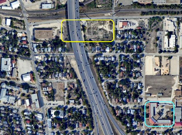
rectangle.) Above Right: In
this larger view captured by Google Earth in 2023, Page Middle School is marked
by the blue rectangle at the intersection of Berkshire and Yorkshire. Page Junior High, which Kott notes was "...torn down in the early
1950s" was rebuilt and at some later date renamed Page Middle School. Below: This
magnified view from 2023 illustrates the path of the spur that Kott references.
As the inset shows, rails are still intact in the surface of W. Boyer St.
