Texas Railroad History - Tower 109 - San Antonio
Crossing of the San Antonio Belt & Terminal Railway and
the San Antonio & Aransas Pass Railway
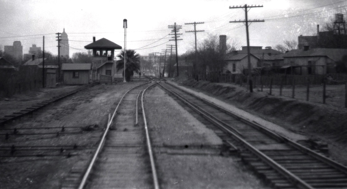
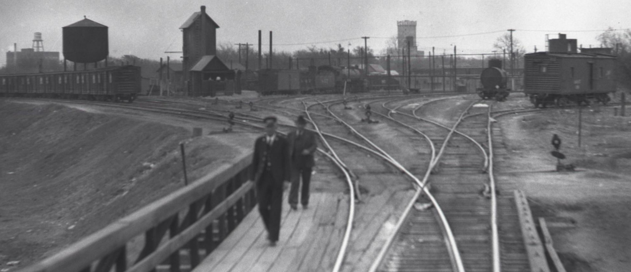
Above Left: This photo
of Tower 109 was taken by John W Barriger III in the 1930s from the rear
platform of his business car. He was facing north -- his locomotive was facing south,
but since passenger trains accessed the
Missouri - Kansas - Texas (MKT, "Katy") Railroad station by backing into it, it is
unknown whether he is actually moving toward the tower or away from it.
Barriger's train is on Katy tracks leased for 99 years from the San Antonio
Belt & Terminal (SAB&T) Railway. Tower 109 is flanked in the
background by the prominent
Smith-Young Tower
which had opened in 1929. The tracks of the
San Antonio & Aransas Pass (SA&AP) Railway are barely visible passing behind the tower.
In the upper right corner of Barriger's photo, an elevated water tank is visible
atop a structure sitting on the rooftop of
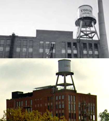
the headquarters of Tobin Surveys. (photo from the John W. Barriger III National
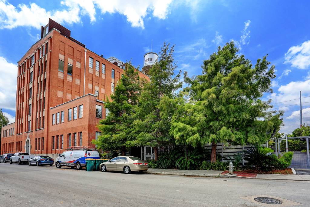
Railroad Library) Above Right:
The upper image is a historic photo of the Tobin Surveys water tank printed in
Concrete Openings, vol. 14, no. 2, June
2005. Tobin Surveys, a company specializing in aerial mapping, was founded in
San Antonio in 1928 and is now owned by P2 Energy Solutions. The building
is no longer the headquarters and it has been repurposed (lower image, Google Street View, April 2022 ) to become the
Camp Street
Residences, with the repainted water tower still intact.
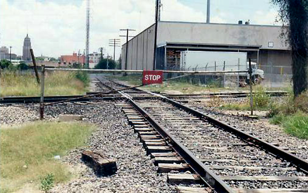
Below Left: This view from
July 4, 1988 is similar to Barriger's
but much closer to the crossing and taken many decades later. The image was posted to trains.com in 2010,
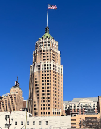
credit unknown. The former Smith-Young Tower, now known as the Tower Life Building (below
right, Jesus Ruben Davila photo, 2023) remains in the picture, but Tower 109 had
closed in 1959 and was replaced by a swing gate normally lined across the
SAB&T tracks.
 |
 |
San
Antonio first obtained rail service in 1877 when the Galveston, Harrisburg & San
Antonio (GH&SA) Railway arrived from Harrisburg, a port near
Houston on Buffalo Bayou. A
few years later, the GH&SA worked with Southern Pacific (SP) to build west to
El
Paso. From the GH&SA yard and depot facilities on the northeast side of town,
San Antonio's substantial population (~ 18,000, the second largest city in Texas
after Galveston) had left no affordable
right-of-way through downtown, so the GH&SA went south down the east side of San Antonio and
then curved west toward Del Rio and El Paso, a route that opened in January,
1883 (shortly thereafter, SP leased and then acquired the GH&SA.)
A
second railroad arrived in San Antonio in February, 1881 -- the International &
Great Northern (I&GN). Its tracks from Longview had reached Austin in 1876,
San Marcos and New Braunfels in 1880, and continued
into San Antonio and Laredo in 1881.
Rail baron Jay
Gould acquired ownership of
the I&GN about the time it reached San Antonio. He had recently been elected
President of the Missouri, Kansas & Texas Railroad (MK&T, renamed the Missouri -
Kansas - Texas Railroad in 1923, but everyone just called it "the Katy".) The Katy was not a
Texas-chartered railroad; it had been allowed to use its Kansas charter in
exchange for building south to the Red River and bridging it. Gould assigned
I&GN ownership to the Katy, but trying to be careful, he also leased the I&GN to the
Katy. Gould had leased the Katy to one of
his Midwest railroads, the Missouri Pacific (MP), enabling him to siphon Katy
profits into a railroad where he had a substantial ownership position. Gould
directed the Katy to begin building south from Denison with a plan to reach
Houston via Fort Worth and
Waco. The tracks belonged to the Katy, but due to
the lease, MP was the public face of the effort. Tracks reached
Smithville in 1887, within fifty miles of the I&GN tracks at San Marcos.
Gould wanted to connect his two railroads at San Marcos, so the Katy commenced
construction there and built east toward Smithville. The tracks reached Lockhart in 1887,
36 miles from Smithville, but the work stopped
due to legal and financial turmoil that had
begun to overwhelm the Gould syndicate.
Gould owned very little Katy
stock, thus its stockholders were able to fire him in 1888 for leasing the Katy
to MP under onerous terms. New Katy management filed for receivership, and MP's lease of the Katy was voided by the Texas Supreme Court in
1891. The ruling required the Katy to obtain a Texas railroad charter but the
Legislature would not grant one until the Katy divested the I&GN. The Katy
was now independent, but with
no leverage and no charter, the Katy accepted the paltry sum of $350,000 from Gould for
the I&GN -- Texas' largest railroad at the time. Ownership passed to his family when Jay Gould died in December, 1892.
The charter granted by the Legislature in late 1891 enabled the Katy to finish the
remaining 36
miles between Lockhart and Smithville. The Katy negotiated a trackage rights
arrangement allowing it to serve San Antonio on I&GN's tracks from San
Marcos. During a Katy-requested charter revision
in 1899, an unrelated provision was added -- by legislators seeking to increase
competition in San Antonio -- that would force the Katy to
build its own tracks from San Marcos to San Antonio. The Katy
fulfilled its obligations, completing the 46 miles from San Marcos to San
Antonio on April 25, 1901. At San Antonio, the Katy tracks merged into the GH&SA
tracks near SP's East Yard in northeast San Antonio. Whereas the Katy had operated
into San Antonio on I&GN trackage rights and used the I&GN passenger station,
its new tracks resulted in using SP's station. SP
then opened its new Sunset Station in San Antonio on January 31, 1903, and the Katy
became a tenant.
A fourth railroad in San Antonio, the San Antonio &
Aransas Pass (SA&AP) Railway, had been chartered in 1884 by Uriah Lott to build
a line between Corpus Christi and San Antonio that
would also run north to Kerrville and
San Angelo. The northerly route terminated at Kerrville in 1887 while the SA&AP
focused on other areas of
south and central Texas, reaching Houston in 1888 and
Waco in 1891. Lott had hired a young Texan named
Benjamin Franklin Yoakum who quickly moved up to the position of Traffic Manager and
later General Manager. The SA&AP's expansion overextended its finances and it went into
receivership in July, 1890, with Yoakum named by the district judge as one of the two Receivers. The receivership ended in 1892 with the SA&AP becoming
informally affiliated with SP. SP could not legally own the SA&AP without
violating Texas' railroad competition laws, but this did not prevent SA&AP stock
from being owned by the Pacific Improvement Co.
(PIC), a holding company through which the four principal founders of SP
exercised ownership control over SP and other (mostly real estate) investments. SA&AP's new management was mostly filled with
"SP men" and it operated cooperatively with SP. In exchange for this
arrangement, SP helped to retire SA&AP debt and agreed to back any construction
bonds issued by SA&AP. As Receiver, all of this was approved by Yoakum and then
by the district judge. This whole arrangement fell apart ten years later due to
an investigation by the Railroad Commission of Texas (RCT), but that's a
Tower 2 story...
 |
German language newspapers
were common in Texas after the end of the Civil War and lasted for
decades. The
German language Freie Presse fur Texas
was published in San Antonio until the 1940s. Railroads advertised
regularly in these newspapers, often with customized German language
ads.
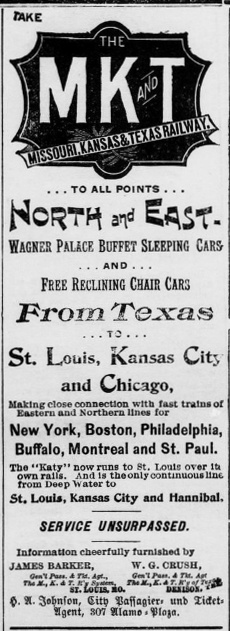
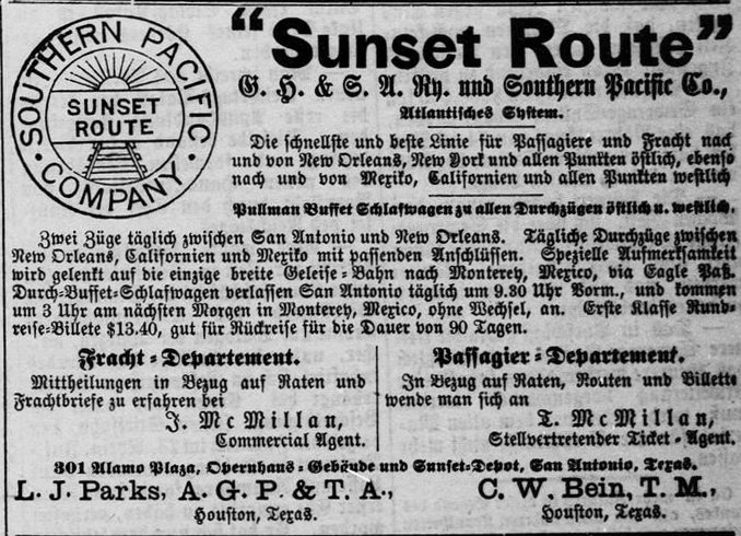
In the
Freie Presse fur Texas of
July 18, 1894, these two ads appeared on the same page. SP's ad (right)
was entirely in German except for the company name and its marketing
brand "Sunset Route".
The Katy's ad (left)
was entirely in English, and there's no doubt that the exact same ad
appeared regularly in the San Antonio
Express, an affiliated newspaper. The ad
claims "The Katy now runs to St. Louis over its own rails", but this was
not completely true. The Katy was still using the I&GN tracks between
San Antonio and San Marcos; it would not build its own line into San
Antonio until 1901.
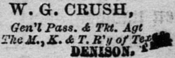
Bottom Right: Note
that at
the bottom of the Katy's ad, it lists W. G. Crush as "Gen'l Pass. & Tkt. Agt
The M., K. & T. R'y of Texas, Denison, Tex." Mr. Crush
would become substantially more famous two years later when he arranged
for two Katy locomotives to crash head-on as a publicity stunt, the infamous
Crash at Crush
on September 15, 1896. |
 |
Despite the Katy operating on its own tracks into San Antonio and sharing SP's Sunset Station and
East Yard, it had not been warmly embraced by San
Antonio's business community. Its previous use of I&GN trackage rights had primarily served the purpose of providing
single-train passenger service between San Antonio and points north (e.g. Fort Worth and Kansas City)
on Katy's route network. In
1904, the Katy completed a line into Austin branching off of its main line at
Granger, a few miles north of Taylor. Shortly
thereafter, the I&GN granted trackage rights to the Katy between Austin and San
Marcos. Despite these efforts in the San
Antonio area, sharing other railroads' terminal facilities -- first the I&GN and
then SP -- effectively made the Katy a second class railroad in San Antonio. It
was understood that the Katy had built into San Antonio in 1901 only because the
charter law required it to do so.
Right: (San
Antonio Express, May 2, 1912) In 1912, a group of
Katy-backed investors formed the San Antonio Belt & Terminal (SAB&T)
Railway to establish a belt line railroad and build new yards and depot facilities for the Katy. Though
heralded as a great advancement for San Antonio, the project did not get
off to an auspicious start. San Antonio was already a city of
100,000 people and the planned rights-of-way would be expensive to
acquire. It would branch
off of Katy's main line in northeast San Antonio about a half-mile shy
of where the Katy reached the GH&SA yard. It would proceed due south, cross the GH&SA main line
where an interlocker was planned, and continue two miles farther south where it would begin a sweeping
curve to the west along Westfall Ave. The north / south right-of-way was only two miles east
of the center of San Antonio, hence there were businesses and other
private landowners that would be inconvenienced. After turning west, the
route was even closer to downtown, only about 1.5 miles distant, with
the Katy passenger depot planned to be less than a half-mile from City
Hall. Much of the land was privately held, and the
proximity to downtown made
it particularly valuable and thus hard to acquire.
The San
Antonio City Council helped where it could by adopting ordinances granting the SAB&T use
of city streets and other city property. One particularly contentious
council meeting was held on October 1, 1914. As reported the following
day in the San Antonio Express, the
council completed a "second reading" of the franchise ordinance (a third
reading was required before adoption.) Citizen speakers complained about
a variety of topics, most especially that granting the franchise would
damage parts of San Antonio, resulting in reduced property values and
thus lower taxes to the city. Residents of the Highland Park
neighborhood near Westfall Ave.
were particularly upset. There was also concern that the SAB&T was
insufficiently capitalized to actually complete the project (or...pay
court judgments for damages from potential citizen lawsuits that would
be filed against it.) Another theme -- why wasn't Katy management acknowledging its role? One
speaker commented... "If
this is really the Missouri, Kansas and Texas of Texas, they should come
openly before the city and above board say so and assume the damage
inflicted on citizens of this city." The SAB&T's attorney asked the
council to expedite its approvals "...to prevent the invalidation of
a contract for the sale of bonds to cover construction made before the
European war." The Great War had just begun, and there was
concern it would exacerbate the tight money situation and delay the
entire project. The ordinance was not adopted, but on April
15, 1915, the San Antonio Light
published the entirety of a new ordinance for the SAB&T that had been introduced to the council for
a first reading. |
 |
On May 13, 1915, the SAB&T finally got its franchise
from the city to enable it to build on particular city streets and property. The
ordinance required the SAB&T to commence construction within one year. The
railroad began right-of-way and property acquisition in remaining areas while the
detailed planning continued. The SAB&T tracks would need to cross the GH&SA
twice. One of the crossings was on the south side of town at the San Antonio
River, about 3,000 feet east of Tower 2. The
railroads agreed that this crossing would be grade-interlocked (and
Tower 112 opened there at the end of 1919.) The
other crossing was east of SP's East Yard, and SP insisted that it be
grade-separated. The location was near where the SAB&T would connect to the Katy
main line and was
sometimes described as "near the oil tank property." The operational impact
of a grade crossing would be significant to SP due to the proximity of East
Yard. SP also objected that
the "damages" set to be paid by SAB&T for building across the GH&SA were inadequate.
The county Board of Appraisers had adjudicated the impact as "minor" (whereas
SAB&T's "damages" for crossing the GH&SA near the San Antonio River
was
assessed at $1,590.) SAB&T was opposed to a grade-separated crossing; it
simply
did not have the budget to support bridging the GH&SA double-track main
line. Unable to agree, the railroads would be forced to live with
whatever decision RCT made after a hearing was held on the matter.
 |
|
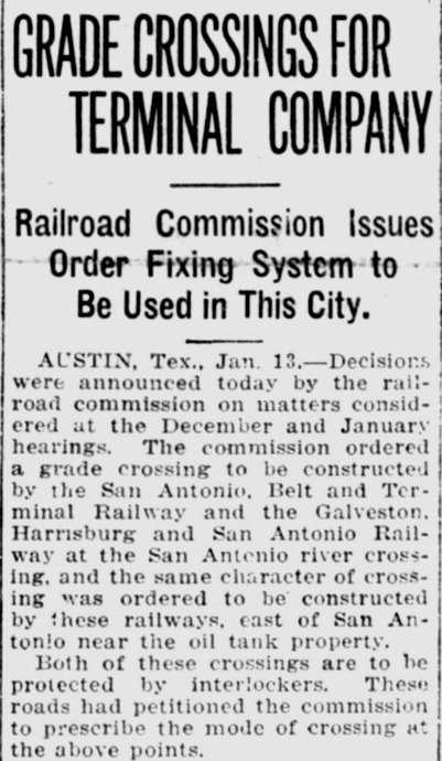
Far Left: The
San Antonio Light of January
13, 1917 reported RCT's order that both crossings be grade-interlocked.
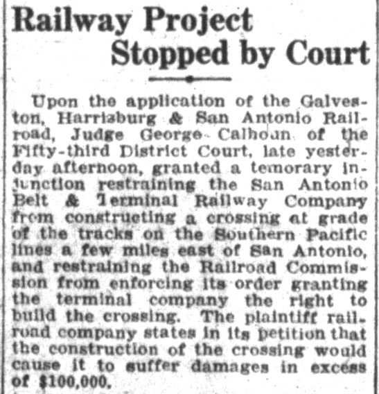
Left Top: (Austin Statesman, January 30, 1917)
Unwilling to accept RCT's order, SP obtained a temporary injunction from a district
judge in Austin restraining RCT from enforcing its order and restraining
SAB&T from building across the GH&SA main line. SAB&T responded with a
temporary injunction from a San Antonio district judge restraining SP
from interfering with SAB&T construction crews as they built across the GH&SA.
The dueling injunctions led nowhere while appeals were considered. Behind the scenes, serious negotiations
ensued, with the Katy getting directly involved.
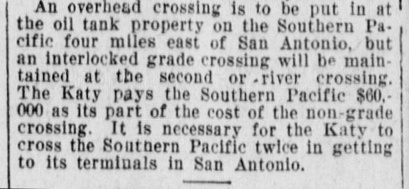
Left Bottom: The
San Antonio Express of March 31,
1917 reported that an agreement to use an "overhead crossing" had been
reached and that the Katy would be paying $60,000 to SP. Why? Instead of
the SAB&T bridging the GH&SA, SP would build the bridge to pass over the
SAB&T.
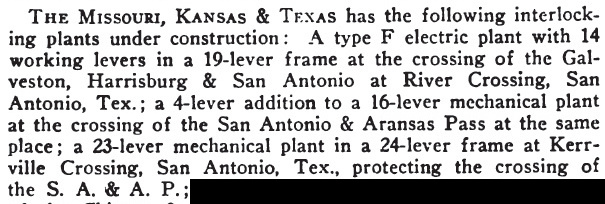
Below: The
September, 1917 issue of Railway Signal
Engineer reported three interlockings in work for the Katy
(SAB&T) in San
Antonio. The interlocker at River Crossing would become Tower 112. The "4-lever addition"
was an expansion at Tower 2 to account for the new SAB&T track
paralleling the GH&SA. The interlocker at Kerrville Crossing became Tower 109.
 |
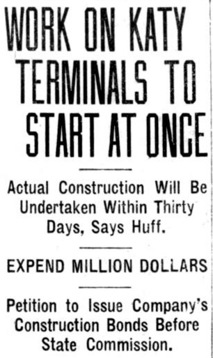 |
Left: The
San Antonio Light of March 21, 1916 carried
an article explaining that SAB&T had applied to RCT for permission to
issue $1.75 million in bonds for the construction of the Katy's
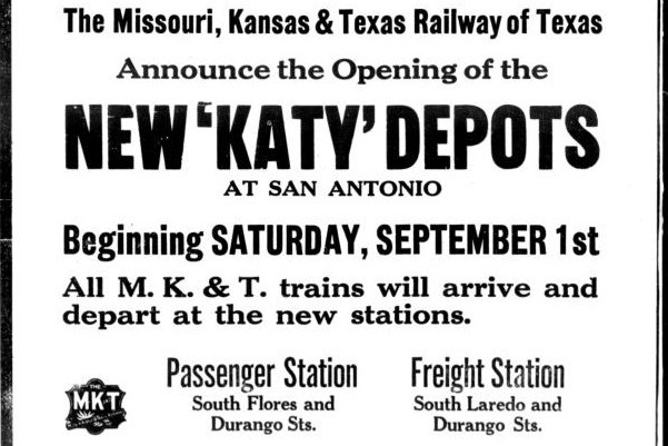
terminals. Right: A little over a
year after construction began, the new Katy passenger station opened on September 1, 1917. The first arrival was the
Katy Flyer from St. Louis and Kansas City, followed twenty minutes
later by train No. 19 from Houston (via Smithville.) The first departure
was train No. 4 for Austin and Waco. (San
Antonio Express, September 1, 1917)
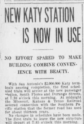
Below:
San Antonio Light, September 1,
1917
 |
 |
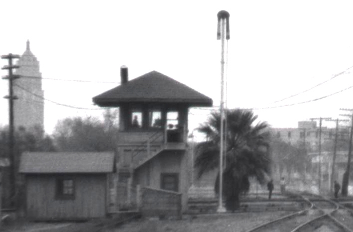 |
Left:
Even in this close-up view of Barriger's photo of Tower 109, it may not
be obvious that the tower was a concrete structure. Concrete was commonly
used as the structural basis for towers designed by the Katy, at least in Texas. Tower 109 was essentially a mirror
image of Tower 53 in Fort Worth, with the
operations room door on the right side instead of the left. Other
concrete towers built by the Katy include Tower 93
at Denison and Tower 112.
Having created the need for Tower 109 by being the second railroad
to arrive at that spot, the SAB&T was responsible for the entire capital
expenditure for the tower and interlocking plant. The tower was operated by Katy personnel,
but the SA&AP shared the recurring cost of staffing and materials for
operations and maintenance. The
typical sharing arrangement was based on the ratio of the interlocker
functions used by each railroad compared to the overall total function
count. For Tower 109, the precise split is unknown, but RCT records show
that the tower opened with a 30-function interlocker. This was an
enormous function count for a simple single-track crossing that had, at
most, one connecting track!
The size of the interlocking plant
suggests that Tower 109 was controlling much more than simply the grade
crossing. As Barriger's photo shows, the SAB&T only had a single
track across the SA&AP, but had double tracks
immediately north and south of the diamond. Switches and signals (and
perhaps derails) for these tracks probably accounted for some of the
additional functions necessitating a larger interlocking plant. Barriger's photo only
shows one set of semaphore signals, but there were likely additional
signals and switches along the entire line. |
In the Transportation Act of 1920, Congress directed
the Interstate Commerce Commission (ICC) to promote and plan consolidation of
U.S. railroads into a limited number of "systems". The ICC responded by hiring
economist William Z. Ripley to develop a plan. The so-called "Ripley Plan"
proposed that SP head one of these systems and that the SA&AP become part of it.
Although the Ripley Plan was never formally implemented, the authority of the
ICC to regulate interstate railroads granted by the Act overrode the power of state
railroad commissions. On December 6, 1924, SP filed an application with the ICC
for authorization to obtain control of the SA&AP. The State of Texas objected,
but the ICC granted SP's application. In March, 1925, the SA&AP was re-acquired
by SP and leased to the GH&SA. In 1927, SP leased the GH&SA and various other
Texas properties to the Texas & New Orleans (T&NO) Railroad. These
railroads
would become fully merged into T&NO in 1934 as it became SP's primary operating entity
for Texas and Louisiana lines. The T&NO corporate entity was dissolved in 1961
and its tracks and rolling stock reverted to SP identity.
In October,
1941, the Katy sought ICC approval to modify the Tower 109 interlocking. The
specific changes were "...installation of track circuits and electric switch
locking, in lieu of detector bars, and removal of two derails on the T. & N. O.
and three derails on the M-K-T." For safety reasons, the request was
opposed by labor unions. Approval was granted on
December 8, 1941 and the corresponding ICC report
provides details of the precise locations for various signals and derails. It
notes that the Katy operated six passengers trains (and zero freight trains)
through the interlocker daily, along with an average of forty switching
movements. The T&NO tracks past Tower 109 were being used a handful of times
each day for switching movements, and "only a few occasions" for T&NO
passenger or freight trains.
 |
Nogalitos Yard was built by the SAB&T a quarter mile south of Tower
109 on a triangular piece of land that was laid
with tracks creating a
large wye. The north leg went to the Katy passenger station and freight
depot about a mile distant. The east leg went to Tower 112 where the SAB&T crossed over the
GH&SA and the San Antonio River, and then continued east and north to
become the Katy's main line to San Marcos. The west leg went to
Tower 105 where it connected into the I&GN main line
heading south at the stockyards. Sloan Yard closed c.1990 and its tracks
were removed.
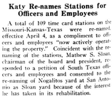
Far Left: The May 1, 1943 edition of
Railway Age
reported that the Katy was renaming various facilities for
officers and employees, most notably changing the name of Nogalitos Yard
to Sloan Yard.
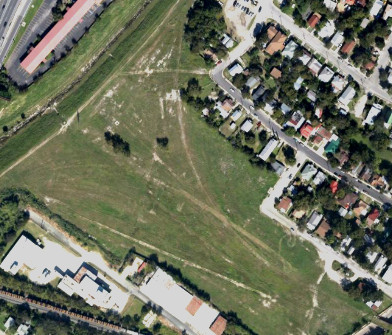
Left:
The Sloan Yard land remained unoccupied for 25 years. In
2015, the KIPP Aspire Academy charter school was built on much of it. (Google
Earth, October 2012) |
Above: This photo of Nogalitos
Yard was taken from the rear platform of John W. Barriger III's business car in
the 1930s. The camera is facing east-northeast from the bridge over San Pedro
Creek on the west track of the wye. Barriger's locomotive is facing west toward
Tower 105, a thousand feet from the bridge. But Barriger's train is not headed
to Tower 105. Instead, his train will back up around the curve to the left and
continue for a mile north to the Katy passenger station. This photo came from
Barriger's camera, but might it have been taken by someone else to capture Barriger briskly walking
onto the bridge to re-board
his car? (courtesy John W. Barriger III National Railroad Library)
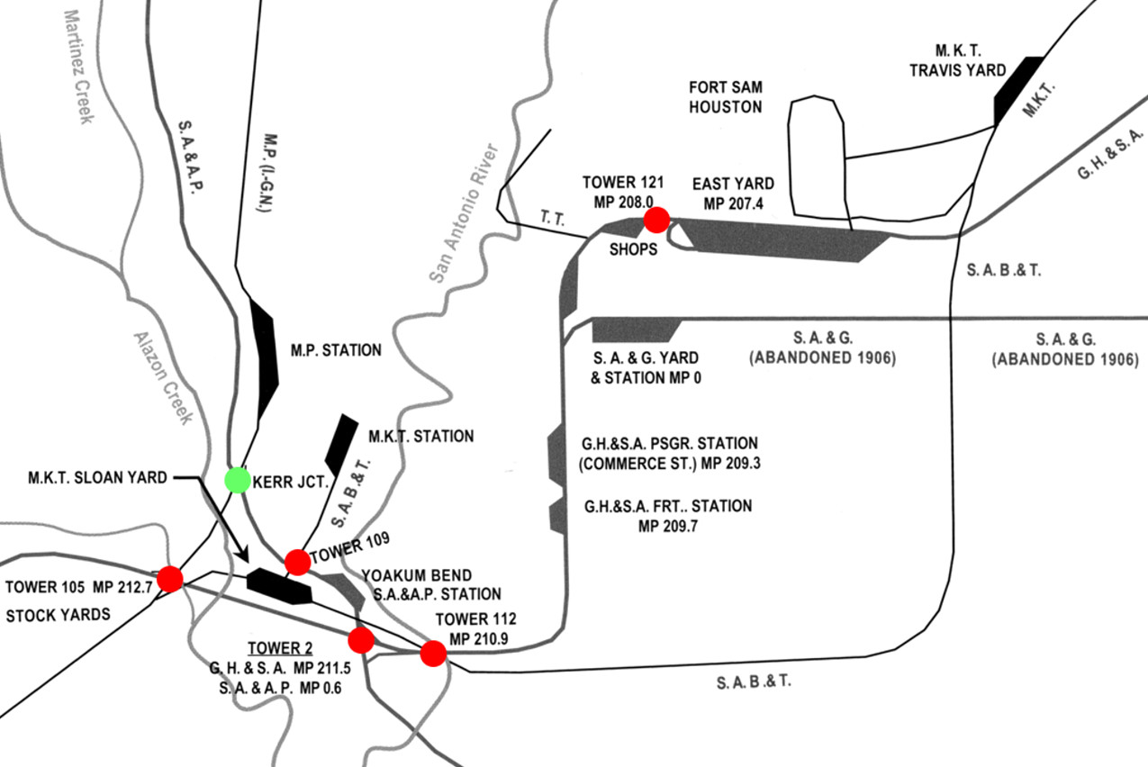
Above: This image is a cropped and annotated version of
a larger map of San Antonio rails produced by David W. Bernstein for his book
Southern Pacific's Eastern Lines 1946-1996
published in 2015 by the North Texas Chapter, National Railway Historical
Society. The red circles highlight the five numbered interlocking towers in San
Antonio. The green circle highlights the crossing of the SA&AP and the I&GN
about a third of a mile northwest of Tower 109. It is marked as Kerr Jct., but
it was also known as Apache Junction. It was not included in RCT's numbering
system, so it presumably was not interlocked. Tower 109 was close enough that it
easily could have controlled the signals and derails for the junction -- if there were any -- but then the I&GN would presumably have shared in
the recurring expenses for operating Tower 109. Published RCT interlocker
reports through 1930 do not show any such involvement by the I&GN.
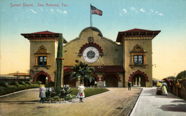
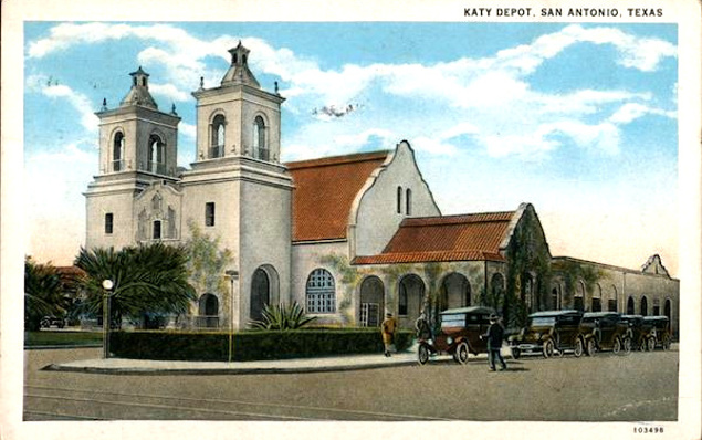
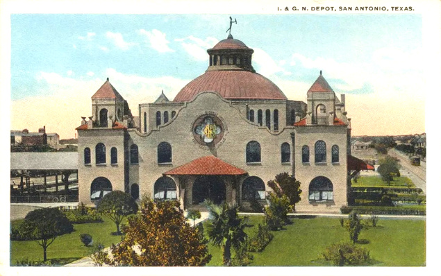
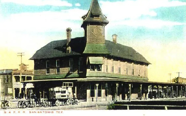
These vintage
postcards show the
mission revival
architecture of the three newer railroad stations in San Antonio:
above left: Sunset Station
opened by SP in 1903, and used by the Katy until September, 1917;
above right: the Katy Station
opened in September, 1917; below left:
the I&GN station opened in 1907. It is marked on the above map as MP station
because MP acquired I&GN in 1925; below right:
the SA&AP depot was built in the mid 1880s, preceding the 1890 onset of
mission revival architecture. It was located at the corner of S. Flores St. and Aransas St.
(which later became S. Alamo St.) about a quarter mile east of Tower 109.
After Amtrak took over U.S. intercity passenger service in 1971, it
continued to use Sunset
Station until the mid-1990s when a smaller (and less expensive to maintain)
station was built nearby. Both stations were located in an area known as St.
Paul Square. Sunset Station was restored and now serves as the centerpiece of an
entertainment district. The I&GN Station is also still standing, though it
was abandoned for many years after MP passenger service ended in September, 1970.
It was restored by the San Antonio City Employees Federal
Credit Union in the 1980s and served as its headquarters. The San Antonio transit agency, VIA
Metropolitan Transit, acquired the building in 2010 to become part of a transit-oriented development
known as VIA Villa. The Katy Station saw its last train in 1964 and the building
was razed five years later. The SA&AP depot was no longer used after SP acquired
the SA&AP in 1925. The building survived with various uses until demolition in 1939.
In 1973, Amtrak began running Inter-American
passenger trains, No. 21 (southbound) and No. 22 (northbound), three times per
week from Chicago through San Antonio to Laredo. Historically, this had been the route of
MP's Texas Eagle passenger service. Stuart Schroeder, a former Tower
112 operator, describes the operation:
The San Antonio station stop for the Inter-American was a patch of
gravel near the abandoned and derelict former International & Great Northern
station near West Commerce Street. Amtrak operated a dedicated bus to and from
the Southern Pacific/Amtrak station at St. Paul Square on East Commerce Street
for the passengers detraining or boarding trains 21 and 22.
On October 1, 1981, Amtrak began truncating
Inter-American trains at San Antonio. This was part of a revised service
which included connecting coach and/or sleeper cars to or from the east/west
Sunset Limited trains. Amtrak adopted a new name for this service, Eagle (becoming Texas
Eagle in 1988.) The new service created logistical issues as all switching
would need to be done at the SP station, but the Eagle would be
arriving and departing over the MP tracks on the other side of town.
With trains 21 and 22
truncated at San Antonio, a route to get the train from the Missouri Pacific on
the west side of San Antonio to the Southern Pacific/Amtrak station had to be
created. A connecting track between the Missouri Pacific main track and Southern
Pacific�s Kerrville Branch was built. The connecting track had the name Kerr
Jct. on the SP and Apache Jct. on the MoP. Trains 21 and 22 would operate over
1.6 miles of the Kerrville Branch between Kerr Jct. and Tower 112. At Tower 112
the trains operated over the double track Del Rio Subdivision to the San Antonio
depot. The Kerr Jct. station name first appeared in Southern Pacific San Antonio
Division timetable number 11 dated October 25, 1981. The operators at Tower 112
copied orders from the Missouri Pacific dispatcher for train 22 which received a
MoP clearance and orders via a high speeder pole at the tower. This was
interesting in that SP and MoP used different rule books at that time. SP had
its own rule book while MoP used the Uniform Code of Operating Rules. There were
slight differences in the forms of train orders.
The 1912 Sanborn Fire Insurance map set of San Antonio
shows that there was a similar connection at Apache Junction in those days (but
whether the location was known as Apache Junction at that time is undetermined;
as Stuart notes above, the Kerr Junction
identity
did not appear until 1981.) Two switches off of the SA&AP Kerrville line just
north of the Chihuahua St. grade crossing (the street no longer crosses the
tracks) led to parallel sidings going north toward the I&GN. On the next map,
those two tracks merge into one and then connect into the I&GN. The Kerr
Junction construction effectively reinstated this earlier connection.
 |
The I&GN had
been acquired by MP in 1925 (and due to a reorganization out of
receivership in the early 1920s, it had become the "I-GN".) In 1956, as
a result of a financial reorganization of MP at the end of a
receivership that had lasted more than twenty years,
the I-GN was fully merged into MP and its name no longer used.
MP was acquired by Union Pacific (UP) in 1982 but continued to operate
separately.
The Katy remained independent until 1988 when it was
re-acquired and merged into MP, roughly a hundred years after the Texas Supreme
Court had broken MP's lease of the Katy during the Gould era. With the Katy
merged into MP, Sloan Yard was no longer needed and was closed.
In 1996, UP
acquired and merged SP. The SP and MP entities were soon
dissolved and all operations were conducted henceforth as UP.
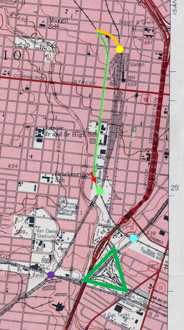
Left: This snippet
from a 1953 USGS topographic map has been annotated to depict some of
the changes in the vicinity of Tower 109 (blue circle.) MP's acquisition
of the Katy in 1988 led to the closure of Sloan Yard (green triangle),
followed by abandonment of the tracks to the north and removal of the
swing gate -- photo at top of page -- at the Tower 109 crossing. Tower
105 (purple circle) remains an important junction, now serving UP tracks
in all directions.
The tracks of the SP (SA&AP) Kerrville Branch past the Tower 109 site
remain in use. SP had abandoned the final 49 miles into Kerrville in
1970, and the line was eventually cut back by UP to the Beckmann Quarry
on the northern outskirts of San Antonio. The UP/SP merger allowed
removal of the Kerrville Branch tracks on Comal St. (green highlight) by
adding 1,600 ft. of track (orange) connecting the Kerrville Branch to
the former MP tracks about 750 ft. north of the I&GN depot. The switch (yellow circle) merges trains from the
quarry onto the former MP tracks. Quarry trains move back to the
Kerrville Branch by taking the switch at Kerr Jct. (green circle.)
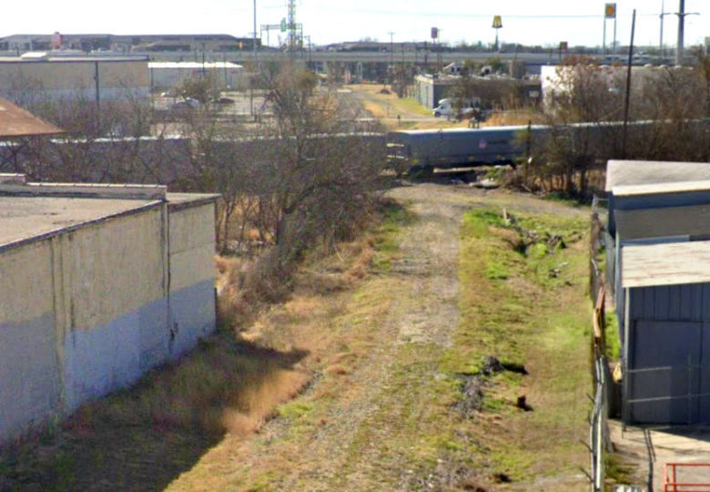
Below:
This Google Street View of the crossing at Apache Junction / Kerr
Junction was captured in March, 2022. The camera (red arrow on map) is
facing southwest from the Guadalupe St. bridge over the former Kerrville
Branch right-of-way. The train is on the former MP/I&GN tracks.
Barely visible in this view, the Kerrville Branch tracks
remain intact beyond the crossing, accessible from the MP tracks via the
Kerr Junction switch (which does not appear on the map; it did not exist
in 1953.) Tower 109 was located just beyond the freeway in the distance.
 |
Observations of A. Tyrrell Kott
"One of the
interesting things about Tower 109 was that the otherwise double track line from
Sloan Yard to the passenger depot necked down to single track to cross the SA&AP
Kerrville branch right at the tower. An industry siding off the SA&AP also
crossed the MKT single track a few feet north of the main line
SA&AP crossing. I think the abandonment of Tower 109 was occasioned
more by a drop in passenger and freight (to the freight station)
movements on the double-single-double track MKT line than any
traffic on the Kerrville branch. However, in late steam days,
I used to see Mk-5 2-8-2s on the Kerrville branch with long strings of hoppers
and gondolas from the same gravel quarry that it serves to this day. As an interesting note, Union Pacific did not realize that
they still served a customer north of this crossing, and they
took up the diamond in 2000 in error and disposed of it!! The
industry (Judson Candy Co.) still received occasional tank cars
of syrup and a piece of track had to be placed over the ex-SA&AP main with a
crane every time a car had to be set out or retrieved!
I was unable to get photos of the actual operation; does anyone
have some?? This strange operation persisted for about a year. As for Tower 109, I measured it in the 1970s and it had been abandoned for
years then. It was physically torn down in 1978 or so. I rode the Texas Special
once a week to San Antonio from September, 1963 until it was cut off in the summer of
1965 and I remember that Tower 109 was abandoned then, although in much better
condition. It must have been abandoned in 1960 or so."
The Judson Candy factory along the SAB&T
right-of-way was converted to
loft
apartments and condos in 2007.
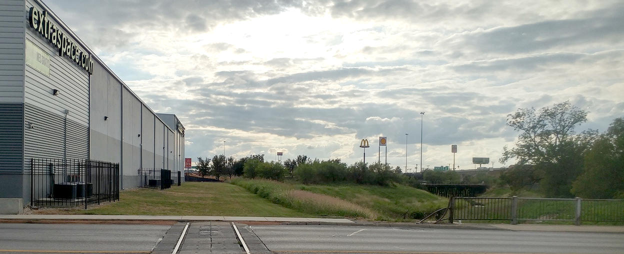
Above: This image is extracted
from a photo Noe Gutierrez took on November 5, 2019 looking south from S. Alamo
St. toward the Tower 109 crossing. The Kerrville Branch bridge over San Pedro
Creek is visible to the right. Fresh dirt can be seen straight ahead -- a new
apartment complex was being built across the former SAB&T right-of-way.
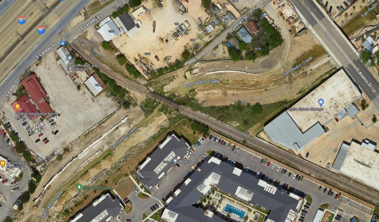
Below: Can you spot the site
of Tower 109 in this Google Maps satellite image from March, 2023? In addition
to the completed apartment complex, the entire San Pedro Creek drainage is
experiencing massive change as part of the
San
Pedro Creek Trail construction. The tower sat where the cars are parked
facing the Kerrville Branch tracks at the left end of the apartment complex
parking lot.