Texas Railroad History - Towers 13
and 14 -
Houston (Eureka and Chaney Junctions)
Two Major Southern Pacific Railroad Junctions in Northwest Houston
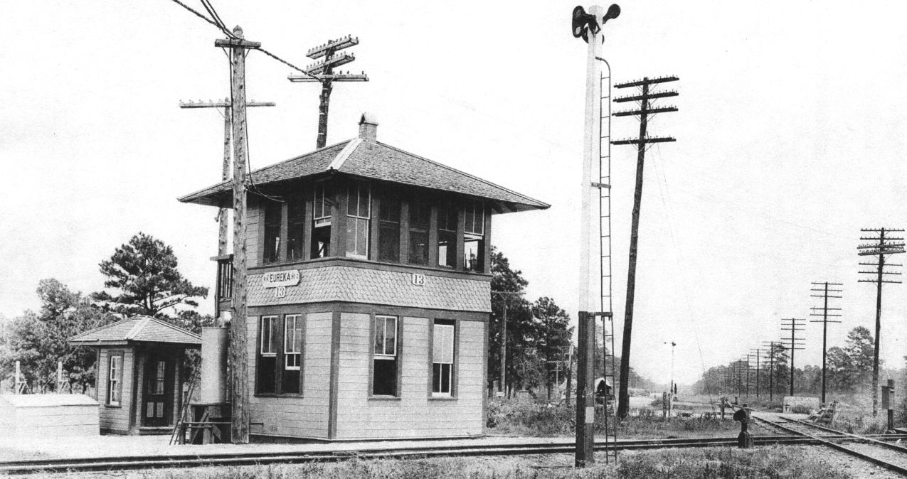
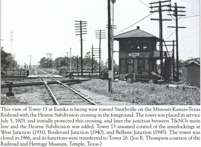
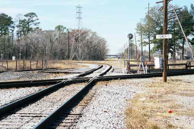
Above: This undated photo of
Tower 13 was taken facing east along the Missouri - Kansas - Texas ("Katy") railroad,
apparently not in wintertime judging by the
open windows. The "fish scale"
pattern between the stories identifies the tower as being of Southern Pacific (SP)
heritage, identical to many other SP towers in Texas (e.g.
Tower 26, Tower 30, Tower 81,
etc.) (Carl Codney collection) Below Left:
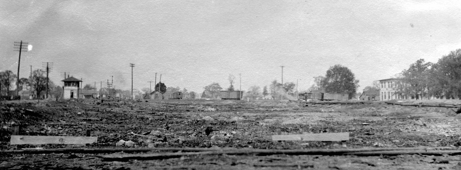
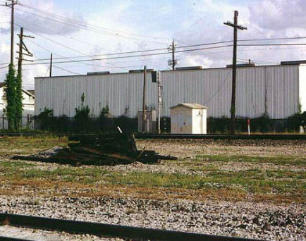
Tower 14 (with magnification below right)
sits to the edge of a large construction site in this photo. The angle of the
rolling stock and the known location of the tower implies that the camera is
east-northeast of the tower facing west, about where the Industrial Cotton Oil Co. had been
located. (photo by James Pirie c. 1912; all James Pirie photos are from the collection of the Texas
Department of Transportation)
The Galveston & Red River (G&RR) Railway was chartered
in 1848 with a grand plan to connect the port of Galveston with the Red River
where railroads from the Midwest were expected to arrive. Unable to raise
sufficient capital, the project languished until an unrelated opportunity arose:
agricultural interests in Chappell Hill needed better transportation to the
Houston market. Chappell Hill was 60 miles northwest of Houston and, critically,
was located west of the Brazos River, a formidable obstacle due to its width and
tendency to flood. A meeting was held in 1852 to discuss Chappell Hill's
transportation issues; Paul Bremond, one of the founders
of the G&RR, attended. He suggested that in exchange for financial backing from Chappell
Hill investors, the G&RR could be re-chartered to start construction in Houston
and pass close enough to Chappell Hill that a short branch could be built.
Bridging the Brazos was not necessary for the G&RR to reach the Red River, but a
branch line was plausible. Bremond's proposal was accepted and the
Legislature approved the change in 1853.
That same year, while Bremond
and Chappell Hill residents began to raise capital for the G&RR, the first
actual track construction in Texas began at
Harrisburg, a port on
Buffalo Bayou southeast of Houston. The Buffalo Bayou, Brazos and Colorado
(BBB&C) Railway began building west that year with twenty miles of track laid to
Stafford's Point, followed by twelve additional miles in 1855 to Richmond. While
the BBB&C remained in Richmond in 1856, the G&RR completed its first 25 miles
out of Houston to Cypress, arriving just as the Legislature approved another
charter amendment granting a new name,
the Houston & Texas Central (H&TC) Railway. Unfortunately for Chappell
Hill, the amendment prohibited H&TC from building branch lines until the main
line was complete (but Chappell Hill soon had a branch line
anyway!) Passing through Hempstead in 1858, the H&TC
turned north to Navasota and stopped at Millican for the duration of the Civil War.
Meanwhile, the BBB&C had resumed construction in 1857 and by 1860 had reached
Alleyton, on the banks of the Colorado River 48 miles west of Richmond, where it
stopped for the Civil War. After the War years, construction continued for both
railroads. H&TC
rails reached
Denison at the Red River in 1873. The BBB&C,
restructured and recapitalized as the Galveston, Harrisburg & San Antonio
(GH&SA) Railway, proceeded west toward San Antonio, arriving in 1877.
The
GH&SA's line out of Harrisburg was located several miles south of Houston, so
the GH&SA didn't actually serve the city. By 1877 it was clear that
Houston
would become the dominant commercial center of the area so the GH&SA obtained
trackage rights into downtown on the International & Great Northern from
Pierce Junction in 1877. Around this time, Southern
Pacific (SP) began discussions with the GH&SA about extending the line from
San Antonio to
El
Paso. With funding and additional construction crews provided by SP, the GH&SA
built west from San Antonio and east from El Paso until the teams met at the
Pecos River on January 12, 1883. A silver spike was driven signifying completion
of a major part of SP's southern transcontinental route. The GH&SA had
already begun
calling their line "the Sunset Route", and SP appropriated the moniker for the
entire route. Anticipating completion
of the El Paso line (and undoubtedly at the urging of SP), the GH&SA built its
own line into Houston. In A History of the
Texas Railroads, the 1941 definitive history of Texas railroading, author
S. G. Reed states this line was built in 1881, but other sources say 1880.
This GH&SA line into Houston began at Stella, an otherwise insignificant
location 0.2 miles west of Pierce Junction, and went north, reaching the H&TC west of
downtown at a location that became known as Chaney Junction. Shortly thereafter, the
GH&SA proceeded
north across the H&TC and curved due east toward the main yard of the Texas & New Orleans (T&NO) Railroad.
The T&NO was the primary rail line east out of Houston to New
Orleans, and it was acquired by SP in 1881. As SP expanded into Texas, it sought
control of other railroads, acquiring the H&TC in 1883. It also leased and
ultimately acquired the GH&SA. At Chaney Junction, the GH&SA made a connection to the H&TC
for access to H&TC's downtown passenger station which became the
station for all of SP's railroads in Houston.
At the other end of
the H&TC line, the railroad's arrival in Denison had matched that of the Missouri, Kansas
& Texas (MK&T,
"Katy") Railroad building south across the Red River. The two
railroads soon began service between Houston and St. Louis. In 1880, the Katy began accessing
Ft. Worth from Denison using trackage rights on the
Texas & Pacific south from Whitesboro (to which a Katy subsidiary had built from
Denison the year before.) From Fort Worth, the Katy resumed construction,
proceeding as far south as Taylor by 1882. In 1887, the Katy again resumed
construction, this time south from Taylor to Smithville, then east toward
Houston, arriving there in 1893. About five miles northwest of downtown Houston,
the Katy crossed the H&TC's tracks. The location became known as Eureka Junction
and the Katy built its main yard directly east of the crossing.
In July,
1901, a new state law mandated interlockers for busy railroad crossings. Without
an interlocker, trains were required to make a complete stop before crossing
another railroad at grade, incurring delay and wasting the energy stored in a
train's momentum. For existing crossings, the capital expense of installing an
interlocker would be shared by the participating railroads, so the Katy and the
H&TC developed plans for an interlocker at Eureka Junction. The H&TC and the GH&SA
determined that their crossing at Chaney Junction also needed to be interlocked,
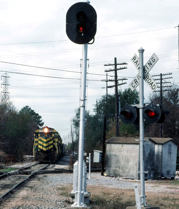
and they likewise established a plan. Tower 13 at Eureka Junction and Tower 14 at
Chaney Junction were built more or less simultaneously and authorized for operation by the Railroad Commission
of Texas (RCT) a few days apart on the 4th and 15th of July, 1903, respectively.
Both towers were designed and built by SP. RCT documentation states that Tower 13 was located at "Eureka" and
that it hosted a
16-function electrical interlocking plant built by the Taylor Signal Co. A 2014 report authored by the City of Houston Archaeological &
Historical Commission explains the origin of the "Eureka" name:
Eureka Junction gets its name from
Eureka Mills, a small Texas community centered around the Eureka Mill, a cotton
mill located five miles northwest of downtown Houston. The mill opened in 1870
under the ownership of a number of Houstonian businessmen and with an initial
investment of $125,000. At its peak, the mill used 17,000 pounds of cotton per
day. In 1872, the mill had 75 employees, all of whom lived in the surrounding
community of Eureka Mills. By 1888, Eureka Mills was a stop on the H&TC line
although the community had already begun to disappear.
Tower 14 was officially reported to be a 33-function
electrical interlocker built by the Taylor Signal Co and located at Chaney
Junction. The reason for the larger function count was that Tower 14 had
connecting tracks between the railroads along with numerous spurs for local
industries. The Industrial Cotton Oil Co. was known to have built a large,
rail-served facility in the northeast quadrant of Chaney Junction. As noted in
the caption, the above photo of Tower 14 was taken in 1912 from
about where the Industrial Cotton Oil Co. had been located.
The obvious question is...what happened to it?
One hundred and one years
later, on January 19, 2013,
Stephen Taylor of Austin posted this intriguing message to the Railspot Yahoo
Group:
"Anne Cook, the photo librarian
with the Texas Department of Transportation in Austin, has asked for our
assistance. She has a series of photographs taken by an engineer named James
Pirie; the images were taken between 1910-1920. The images reflect the
construction of a cottonseed oil mill and warehouses. Her question? Where were
the pictures taken? Here's what we know. One image shows a smokestack lettered
with "Chef Oil", presumably a brand-name for a cooking oil. The mill and
warehouses were for a company called the South Texas Grain Company. The first
image shows an interlocker, on the far left of the image. Subsequent images
shows a large number of railroad tracks and rolling stock and power (steam, of
course). The facility, like every industrial facility in Houston at that time,
had rail service. My hunch is that it was served by the H & TC. South Texas
Grain had a facility very near the H & TC shops; this facility was shown in the
1924 Sanborn Maps. South Texas Grain had a number of facilities in Houston at
that time, but none conform to these images; the warehouses are enormous.
The images are in sequence, starting with a vacant lot with the interlocker
in the background, progressing through construction; many images do show
railroads and rolling stock. What I need is some help pinning down the location.
I suspect that the interlocker might hold the key to the puzzle. I suspect that
the railroad might be the H & TC, as that would have been the logical shipping
choice for much of the cotton-growing sections of Texas. This facility, however,
may not have even been in Houston proper, but in an outlying area. The
supposition that the images are in Houston is based on the fact that Pirie
worked in Houston from 1910 through 1918."
Using interlocker information, Sanborn maps and
assistance from Railspot members, Stephen zeroed in on the likely
location of the mystery interlocker: Tower 14 at Chaney Junction. [Editor's
Note: Had I bothered to fully research the namesake of Chaney Junction,
the answer would have been obvious! As excerpted from the
web article Houston's First Oil
Boom Was Based On Cotton...
"In 1880, the
Galveston Houston [sic] and San Antonio Railroad built a connecting track that
joined its main line, south of town, with a rail yard on the north side of
Buffalo Bayou in downtown Houston. This "entrance" into the city greatly
enhanced the railroad's potential for rail service while also connecting it with
the other large rail line of the city, the Houston and Texas Central. In March
of the same year, Thomas R. Chaney, founder of the Howard Oil Mill Company,
began the construction of a factory to be located adjacent to the intersection
of these two great railroad lines. Over the next three decades, this rail
junction, called Chaney Junction, was to become the focal point of an industrial
district for the local economy's first major oil boom, the cottonseed oil boom."
]
Sanborn Fire Insurance maps of Houston confirm
cottonseed oil factories in the vicinity of Chaney Junction. In particular, the
1907 map shows a large complex on the northeast corner of Chaney Junction
labeled "Industrial Cotton Oil Co." But if a large facility already existed in
1907, how could photos taken c.1912 depict construction of a new mill at the same
location? The most likely answer is that the old mill was razed and a new one
built at the same location. The photo above is the only one in the series that
shows the tower, but it also shows a large debris field in the foreground. This
is not virgin prairie land in Houston; something was located here, and
was either torn down or burned down.
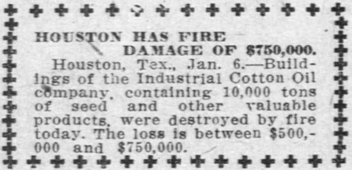
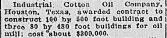
Above Left: El Paso Herald, January 6, 1912
Above Right: This excerpt from
the Richmond (Va.) Times Dispatch dated March 31, 1912 shows that the Industrial
Cotton Oil Co. wasted no time in getting back in business, awarding a
construction contract a mere 85 days after the fire.
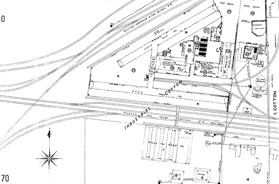
Below: This snippet from the 1907 Sanborn Fire Insurance
map of Houston shows the location of the Industrial Cotton Oil Co. northeast of
the Tower 14 crossing diamond. The complexity of the track arrangement helps
explain the higher function count for the Tower 14 interlocking plant. The Tower
14 structure does not appear at the crossing diamond on this map, but it does on
another overlapping map (further below.)
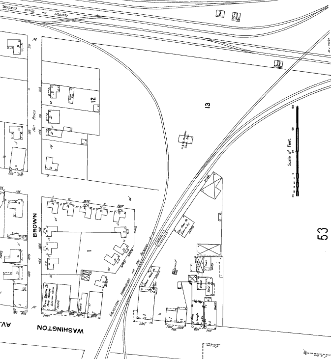
Above: This 1907 Sanborn
Fire Insurance Co. map snippet shows the GH&SA and H&TC diamond in the upper
right corner. The image has been rotated so that north is up (resulting in the
upside down lettering for Washington Av.) Magnification (at
right) reveals Tower 14 as a two-story "Signal Tower" located in
the southwest quadrant. Below:
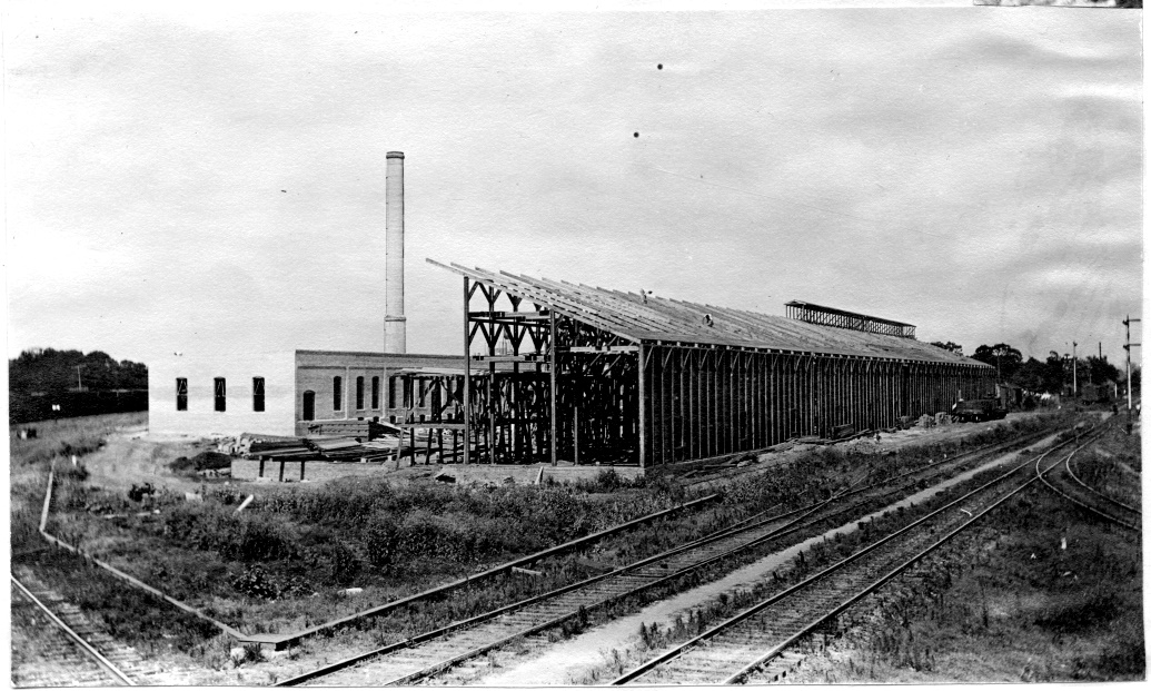
This photo from much later during construction appears to
have been taken facing east-northeast from Tower 14. The double track with semaphores is the
H&TC main line. There is a some kind of crossing in the
immediate foreground (based on the single rail visible in the lower left
corner, presumably GH&SA.) The connecting track visible at the right edge
leads into the GH&SA line to Stella.
(James Pirie photo)
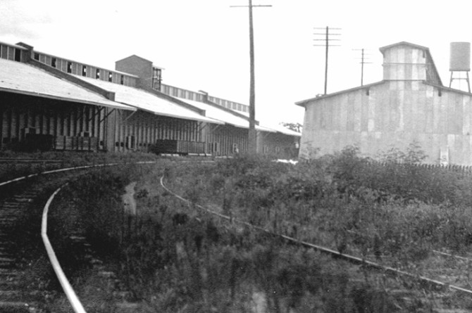
Above: Looking northeast along
the connecting track in 1912 (left) and 1999 (right), the unusual "brick house"
with the peaked roof atop the industrial building has either survived for a
century or was retained during a reconstruction. (James Pirie and Jim King
photos, respectively) Below Left:
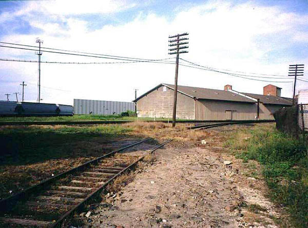
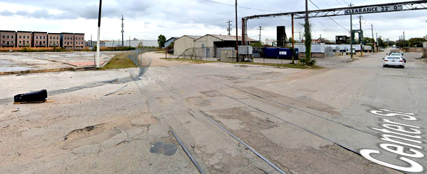
The southeast quadrant connecting track at Chaney Junction is gone, but the
rails remain in the pavement on Center St. as of November 2019 in this view to
the northeast. (Google Street
View) Below Right:
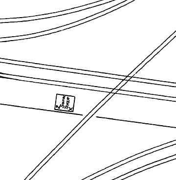
The sign on the side of the
white cabin reads "Chaney Junction". (Jim King, 1999)
In 1912, as the Industrial Cotton Oil Co. was being
rebuilt, the campus of Rice University opened three and a half miles south of
Chaney Junction. The nearby First Montrose Commons subdivision became a popular neighborhood as university professors
and staff moved in. Although construction of the GH&SA line between Stella and
Chaney Junction preceded the founding of Montrose by at least twenty years, the
neighborhood expanded such that the rail line ran right through the middle of
it. To no one's surprise, residents complained to the city
about train noise and blocked crossings. More critically, the line had been
built on an embankment 4 to 5 feet high, creating serious drainage problems in
Montrose. City officials began to pressure SP to abandon the tracks through Montrose. In 1915,
the H&TC built a 9-mile connector south from Tower 13 to the GH&SA
main line at a location called West Junction. Along with the existing tracks
between Eureka and Chaney junctions, the GH&SA began
routing between Chaney Junction and West Junction via Tower 13. Except for
a short spur at Chaney Junction, the GH&SA line from Tower 14 through Montrose
to Stella was abandoned.
On November 17, 1915, SP wrote a short note to RCT stating "FYI, we have
removed crossing of the GH&SA Railway Co. and the H&TC Railroad Co. main line at
Chaney Junction and have discontinued operation of Interlocking Plant #14."
Reed asserts that the final removal of the GH&SA tracks through Montrose to Stella did not occur until
March, 1918. Contemporary newspaper articles explain that the tracks between
Blodgett, at the south edge of the Montrose neighborhood, and Chaney Junction
were gone by the fall of 1915, but the tracks between Stella and Blodgett
remained in place into the early 1920s, partly due to litigation and partly due
to delays incurred because of World War I. Blodgett was the GH&SA crossing of the
San Antonio & Aransas Pass (SA&AP) Railway which had built into Houston from Eagle Lake and
Wallis in 1887-88. The SA&AP had
been owned by SP for eleven years, but was divested under court order in
1903 and became independent. Blodgett was the site of Tower 12, which was
dismantled once the tracks through Montrose had been removed. But this same SA&AP line was now crossed
by the new H&TC connector about four miles west of
Tower 12. Tower 104
was promptly commissioned there in 1916. [The removal of the tracks of both
railroads through Blodgett resulted in extensive litigation, for which the
details are provided under Tower 12.]
SP had planned for a second line that would parallel the H&TC tracks from
West Junction to Eureka Junction, and onward to Chaney Junction. The grading
began in October, 1916 and the line was probably complete sometime in 1917,
although RCT's records say 1918. A court document resulting from the Blodgett
litigation explains that the Eureka - Stella Cutoff was so named because it was
to be the major part of a replacement for the GH&SA's Stella - Chaney Junction
tracks (i.e. it wasn't the Chaney - Stella Cutoff because Eureka - Chaney tracks
already existed.) But the Cutoff did not actually go to Stella. It intersected
the Sunset Route 3.33 miles from Stella, a location now known as West Junction.
Above: This c.1920s T&NO track
chart (courtesy
T&NO Archives) of the Eureka -
Stella Cutoff illustrates the completed double track. RCT records show the
second track as GH&SA construction from Chaney Junction to West Junction,
a distance of 12.18 miles, completed in 1918. Both tracks merged directly into
the Sunset Route at West Junction; today, this is double
track from there all the way to
Sugar
Land. At some point, perhaps during construction of the second line, a new connecting
track for eastward movements was added that merged into the GH&SA main line at a
location now known as Spence Junction. A 1920 SP timetable calls it "East
Junction", and identifies the
opposite end of the connector as "North Junction." Although the construction
date of the "Spence Cutoff" remains undetermined, it was clearly built
to increase the track radius of the
curve required to navigate the acute 66-degree angle for movements between Eureka
Junction and Harrisburg. This presumes that the prior "East H&TC Junction",
a name thus far found only in court documents, is neither
"East Junction" nor "North Junction", and was removed when
the Spence Cutoff was built. The diagram also shows Tower 104 located in the
northwest quadrant of its crossing.
Note that the GH&SA and H&TC are identified as the owners of the east and
west tracks, respectively, between West Junction and Eureka. Functionally, it
didn't matter; they were both SP properties. RCT records list abandonment of
10.54 miles of track by the T&NO in 1934 from Chaney Junction to Eureka
Junction. The distance between Chaney and Eureka is only three miles, and the
double track remains intact, so this may have been removal of spur and siding
tracks. It's also possible this was some sort of an accounting
adjustment
by T&NO since 1934 was the year it formally merged the H&TC and the GH&SA.
Below Left: West Junction's
name has remained unchanged for the past hundred years.
Below Right: The eastern
connection from the former GH&SA main line onto the double track to Tower 13 is
now called Spence Junction. (both images from Google Street View)
At Chaney Junction, the 1907 Sanborn Map shows the H&TC
was already double track, but this appears to be related to the dense industrial
activity near the junction. Other map components show the H&TC double track
extended west a relatively short distance from Tower 14. To the east, the H&TC
was mostly double track as their roundhouse was only a mile from the junction.
Unaffected by abandonment of the line to the south, the GH&SA's single track north and east of Chaney Junction remained intact. Over many years this route morphed into
SP's "Freight Line" that went past the Hardy St. Yard and proceeded onto T&NO's tracks to
Englewood Yard. Eventually, the original H&TC
route became SP's "Passenger Line"
into downtown, going past
SP's Grand Central Station, crossing the Katy at Tower 108,
and rejoining the Freight Line near Tower 26. The Freight Line also crossed the
Katy near downtown. This crossing was ultimately grade-separated; this may not
have been the 1893 configuration when the Katy was built, but the crossing never appeared
in RCT interlocker records.
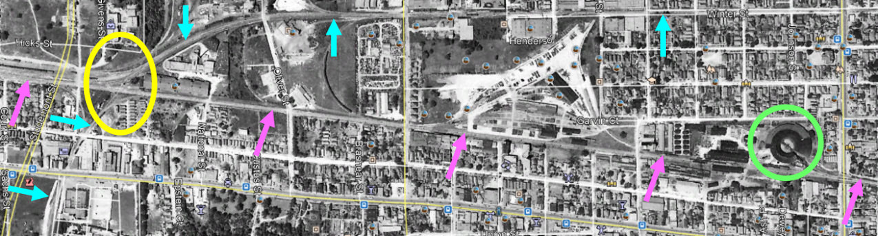
Above: Texas General Land
Office aerial imagery from 1944 (served by Google Earth) shows the slight
diagonal slant of the H&TC main line (pink arrows) across the middle of the image, with Chaney
Junction at left (yellow oval) and the H&TC roundhouse (green circle) at right, just west of Houston Ave. The
GH&SA line (blue arrows) is visible going north through Chaney Junction
and immediately curving due east to head directly to Hardy St. and Englewood
Yards. Tower 13 was located three miles west of Chaney Junction. Below:
annotated 2018 satellite view of Chaney Junction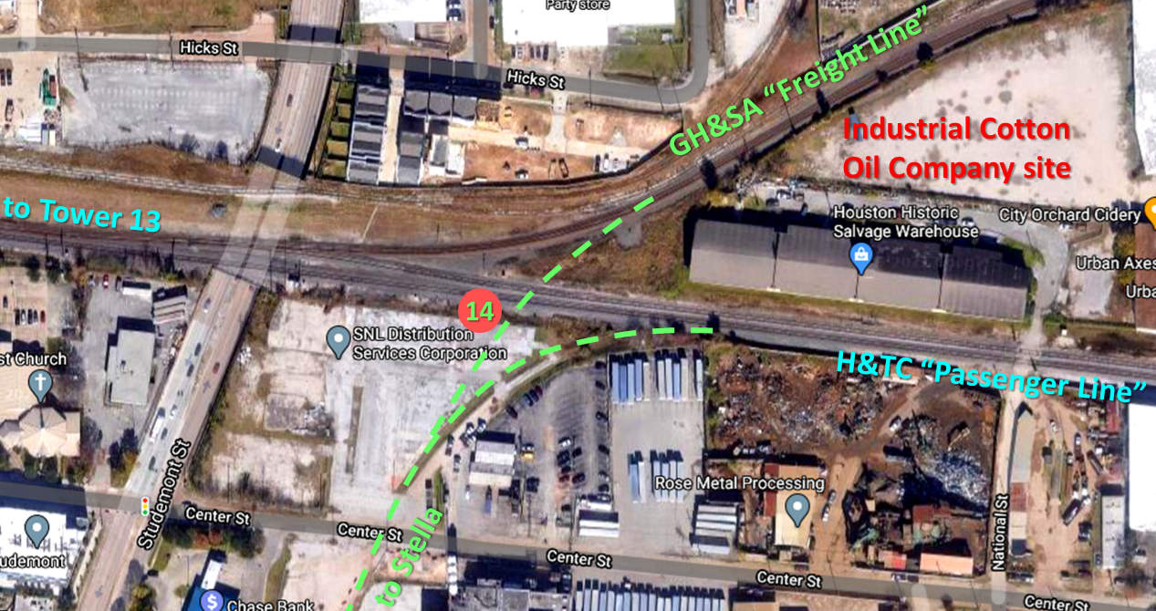
Once Tower 14 was gone, Tower 13 increased in
importance as the only manned facility in the northwest Houston area for
interlocker, signal
and switch control. With SP running a busy double track through Eureka Junction
and the Katy expanding its service, Tower 13 assumed additional responsibilities as various nearby crossings were modified to become remote controlled interlockers.
The last comprehensive interlocker list published by RCT at the end of 1930
shows that Tower 13's plant had already increased to 34 functions. In 1941, an
interlocker controlled by Tower 13 was established at Boulevard Junction, 0.7
miles west of Chaney Junction, for a spur running north into the Houston Heights
area. At the same time, an interlocker was established at West Junction and
control was given to the Tower 13 operator. In 1945, Tower 104's interlocker
became remote-controlled from Tower 13. In 1966, the functions of Tower 13
were transferred to Tower 26 and Tower 13 was
closed. The fate of the structure has not been determined.
These four photos show the changing appearance at Tower 13, all facing west
along the Katy. Above Left:
This photo (c.1950s) and caption appear in
Southern Pacific Railroad in Eastern Texas by David M. Bernstein
[Arcadia Publishing, 2011]. The bridge railings show that the Hempstead Rd.
underpass had already been built. Above Right:
In this 1983 photo by Stephen Hesse, an eastbound Katy train arrives at Tower 13
where two remote controlled interlocking cabins, one with "13" visible on
the side, have replaced the tower structure. The locomotive is about to cross
over Hempstead Rd.
Below
Left: This photo (c.1996) shows that the equipment cabins have been
removed, replaced by a "Tower 13" sign on the power pole. The abandoned Katy
right-of-way is visible in the distance as the tracks now curve south to connect
to the double track heading toward West Junction. Note that the bridge railings
are substantially farther apart than they appear in the two photos above taken
at earlier dates. The wider right-of-way and the rail remnants adjacent to the
railing on the left are evidence of a connecting track that was added for a
short time between the Katy main and SP's H&TC line into downtown. (Bob Smith photo)
Below Right:
In this view from October, 2019 (Google Street View), the Tower 13 sign remains
on the power pole as construction vehicles work changes nearby. (As of 2021, the
work underway is reported to be a project to widen Hempstead Rd. and replace the
bridges.) Unlike the prior photo from 1996, the
abandoned Katy right-of-way is no longer apparent in the distance as new housing
or
apartment complexes have been built across it. The double track to West Junction
is visible at far left.
All of the railroads involved in Towers
13 and 14 eventually became part of Union Pacific (UP). In 1988, the Katy was merged
into UP's Missouri Pacific (MP) subsidiary. In the mid-1990s, UP acquired SP,
and by 1998, both MP and SP were fully merged into UP. At some point in the
1990s, a connection was added at Tower 13 between the Katy main line and the H&TC line into
downtown so that trains on the Katy could access
Englewood Yard via the Freight Line connection at Chaney Junction. The
Katy/H&TC connection presumably did not last long; in 1997, the Katy line west
from Tower 13 to the town of Katy (a western suburb of Houston) was abandoned.
The tracks east of Eureka Yard into downtown were also abandoned, thus only a
small portion of the original Katy right-of-way still has tracks in Houston. The
H&TC line is still in use from downtown through Hempstead to points north, and
the double track from Chaney Junction to West Junction via Tower 13 remains
intact. The GH&SA heritage "Freight Line" and the H&TC heritage "Passenger Line"
both remain in heavy use through Chaney Junction.
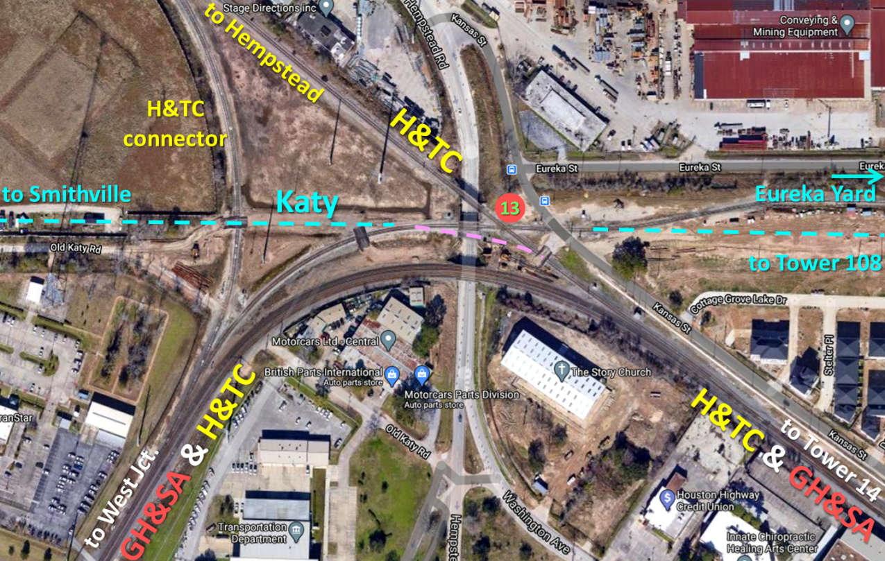
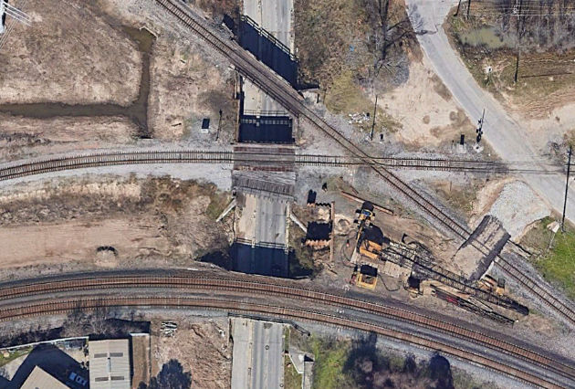
Above: This annotated Google
Maps satellite image from 2018 is marked with the heritage railroads; all tracks
are now owned by UP. Tower13's location (red circle) was on the north side of
the diamond of the former Katy / H&TC crossing. The H&TC / GH&SA double track
between Tower 14 and West Jct. remained south of Tower 13 and did not cross the
Katy. A telltale bridge no longer in use over
Hempstead Rd. marks the connecting track (pink dashes) between the Katy main and
the SP (H&TC) main into downtown. It was used to route trains between the Katy
main and Englewood Yard. The construction vehicles present near the Hempstead
Rd. underpass indicate the initial work to replace the bridges and restructure
the road and the rail lines at Tower 13. This work is on-going as of February,
2021. Below
Left: This Stephen Hesse
photo from 1983 faces northwest on the
former H&TC toward Hempstead.
The bridge railings are for the Hempstead Rd. underpass. As a result of changes
associated with the Hempstead Rd. widening project, this bridge is reported to
be out of service as of February, 2021.
Below Right: This Google Earth
satellite image from December, 2018 shows a more detailed view of the bridges over Hempstead Rd. at
Tower 13. Heavy equipment is in place for the widening project.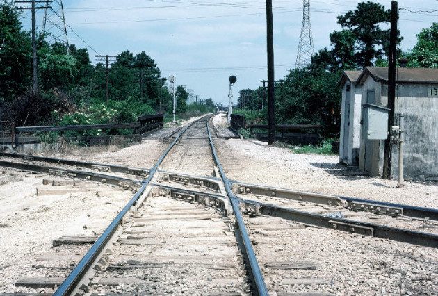
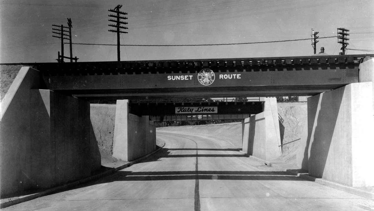
Above: undated historic view
of the Hempstead Rd. underpass, facing north
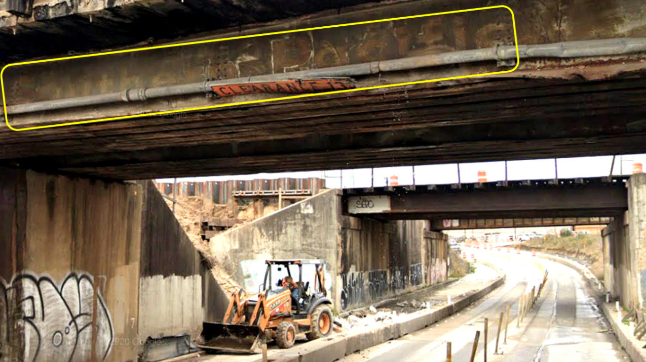
These Google Street Views from January, 2020 face north on Hempstead Rd. at
Tower 13. Above: This view is
just before passing under the double track bridge to West Junction. This is the
first (southmost) bridge of the four beneath which Hempstead Rd. passes. The
bridge's SP heritage remains faintly visible (yellow box.) Substantial
construction was under way in this area both at track level and at street level.
Below: Moving farther north,
the remaining three bridges are visible. The next one
is no longer in use for rails; it was the short-lived connection between the
Katy main and the SP (H&TC) main. The second bridge in this view is the former Katy main line
(with markings still intact), now used to access Eureka Yard. Viewed from
beneath, it appears that the gap between these two bridges is filled above with
wooden planks through which sky is faintly visible. In February 2021 on the
Texas Railroad History Facebook Group, Darrel Yeates reported that this
double-bridge structure has been temporarily reworked to carry the former H&TC
line and the lead into Eureka Yard as part of the widening project, and that the
former H&TC bridge has been taken out of service, presumably to be removed.
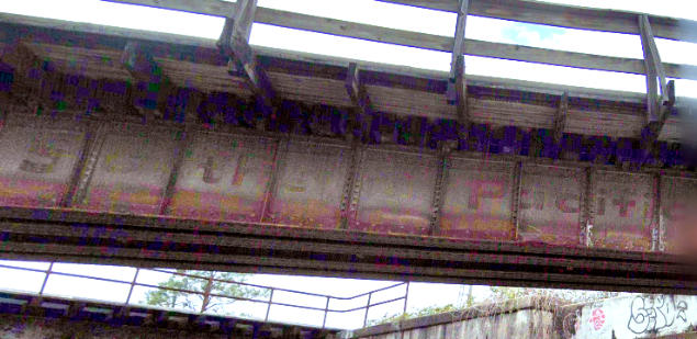
That's the distant bridge that crosses at an angle in the image below. SP
markings remain on that bridge
viewed from the other direction (further below
left.)
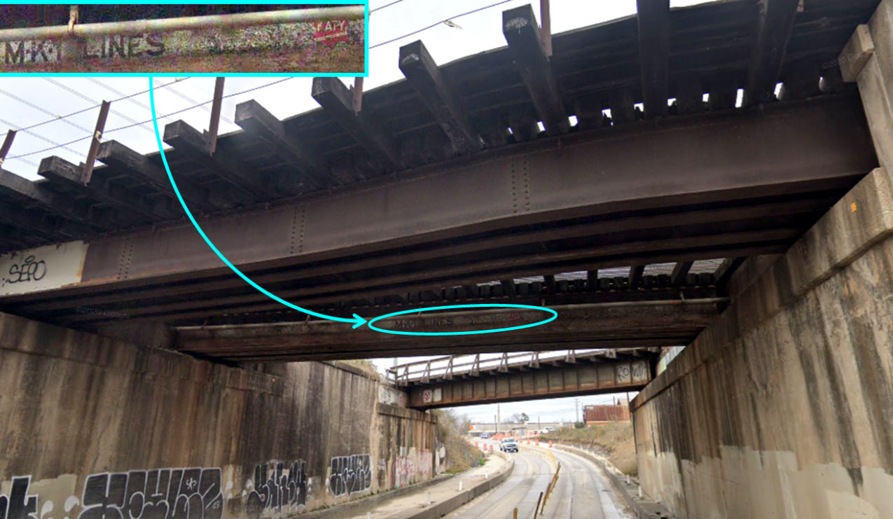
Above Left: Looking south near Tower 13 on Hempstead
Rd., the northernmost bridge reveals its SP heritage.
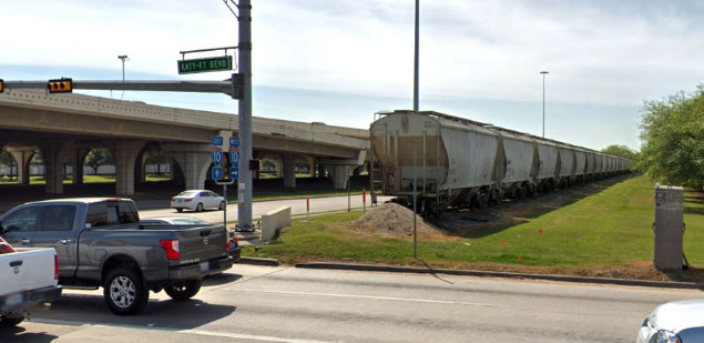
Above Right: Facing west, hopper cars are stored on what
was once the Katy main line. East of Katy - Ft. Bend Rd., the tracks were
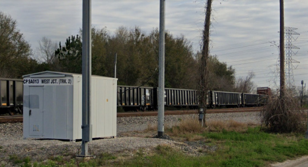
abandoned in 1997 back to Tower 13. Below Left:
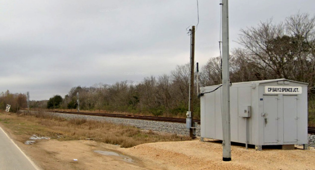
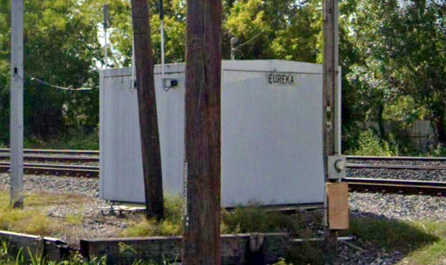
This equipment cabinet is located along the original H&TC (closest track) where
it merges with the double track 360 ft. east of the Tower 13 diamond. Below Right:
SP's Freight Line (on the bridge) crossed over the Katy main line (now a paved
trail) beside White Oak Bayou. The Freight Line's GH&SA heritage means that this
section was built c.1882, roughly ten years before the Katy arrived. When grade
separation occurs, typically the later arrival would build the bridge, but due
to the presence of the bayou, it's possible that the Katy built beneath an
existing GH&SA bridge if the bridge was high enough and long enough. Of course,
it may originally have been a simple grade crossing, but if so, it was never
part of RCT's interlocker management. (all images from Google Street View)
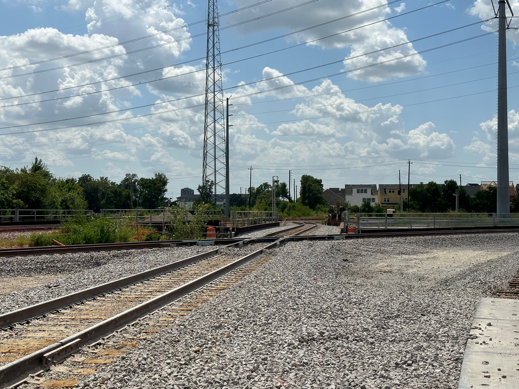
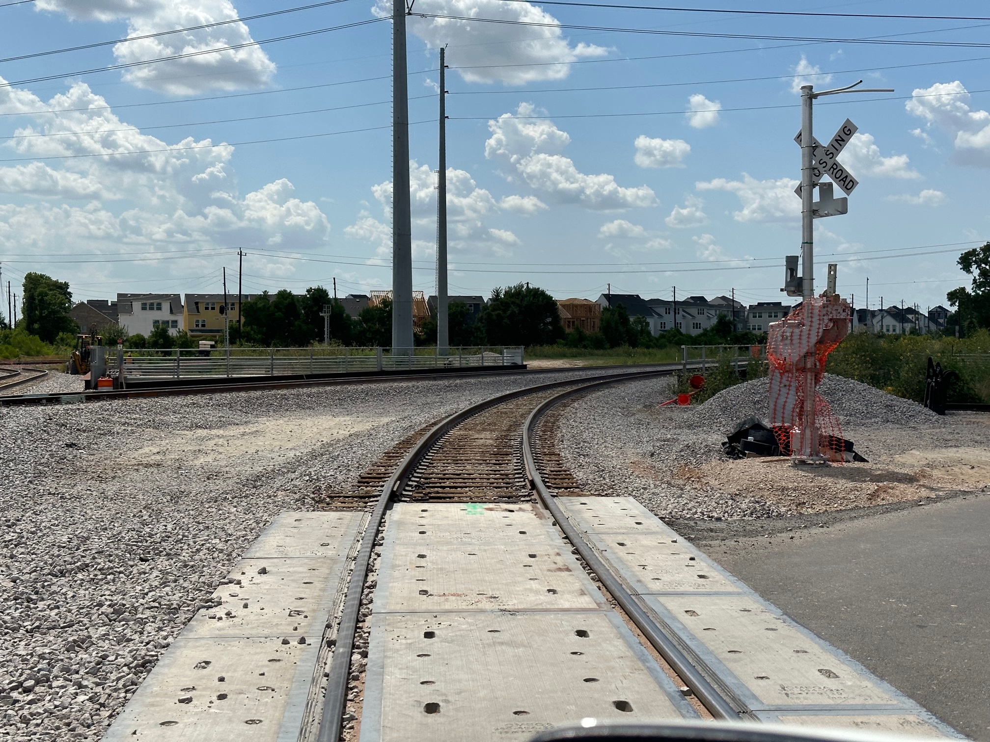
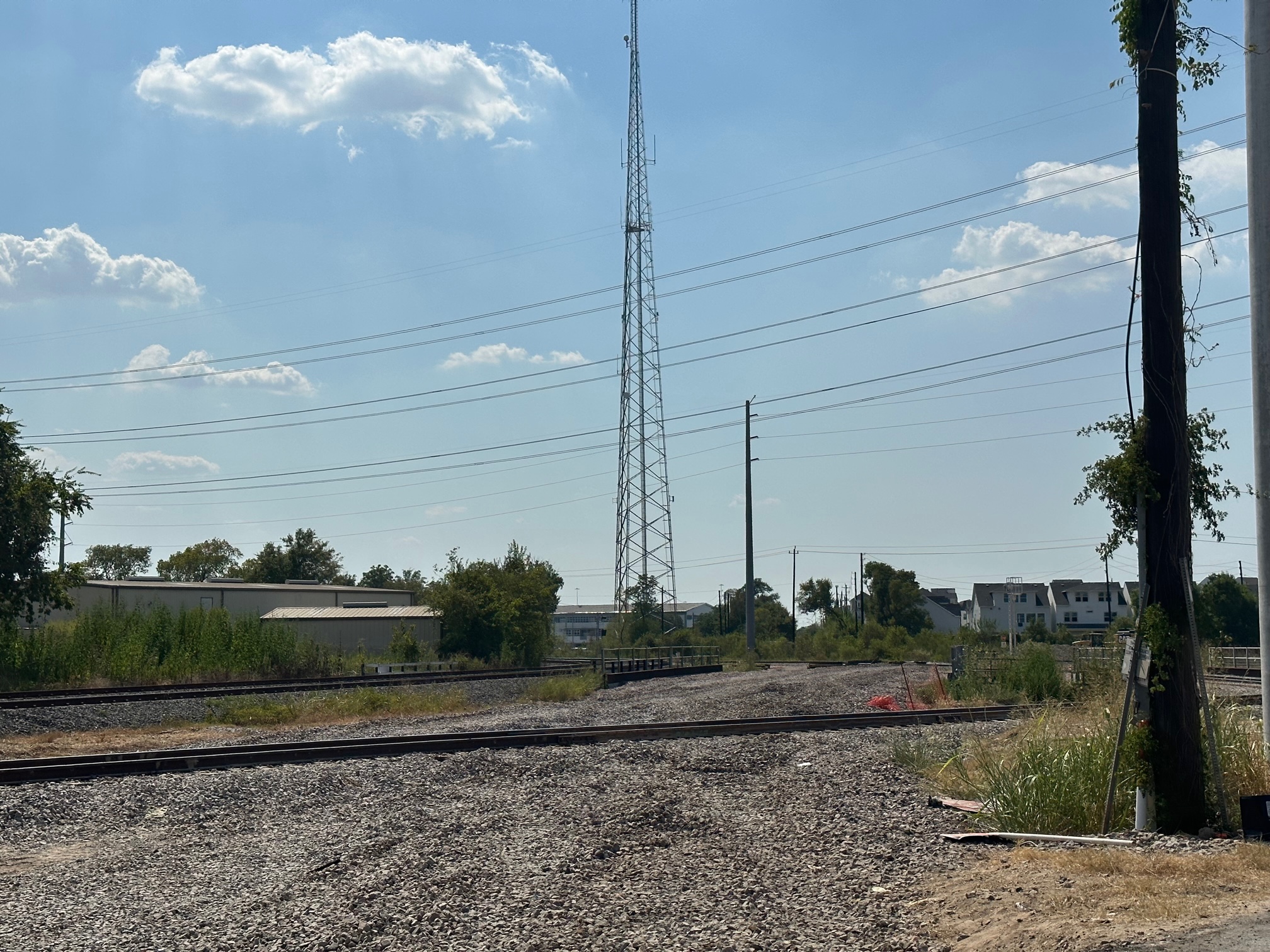
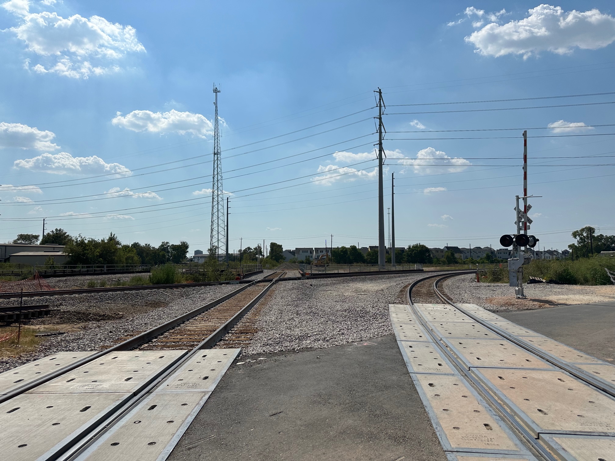
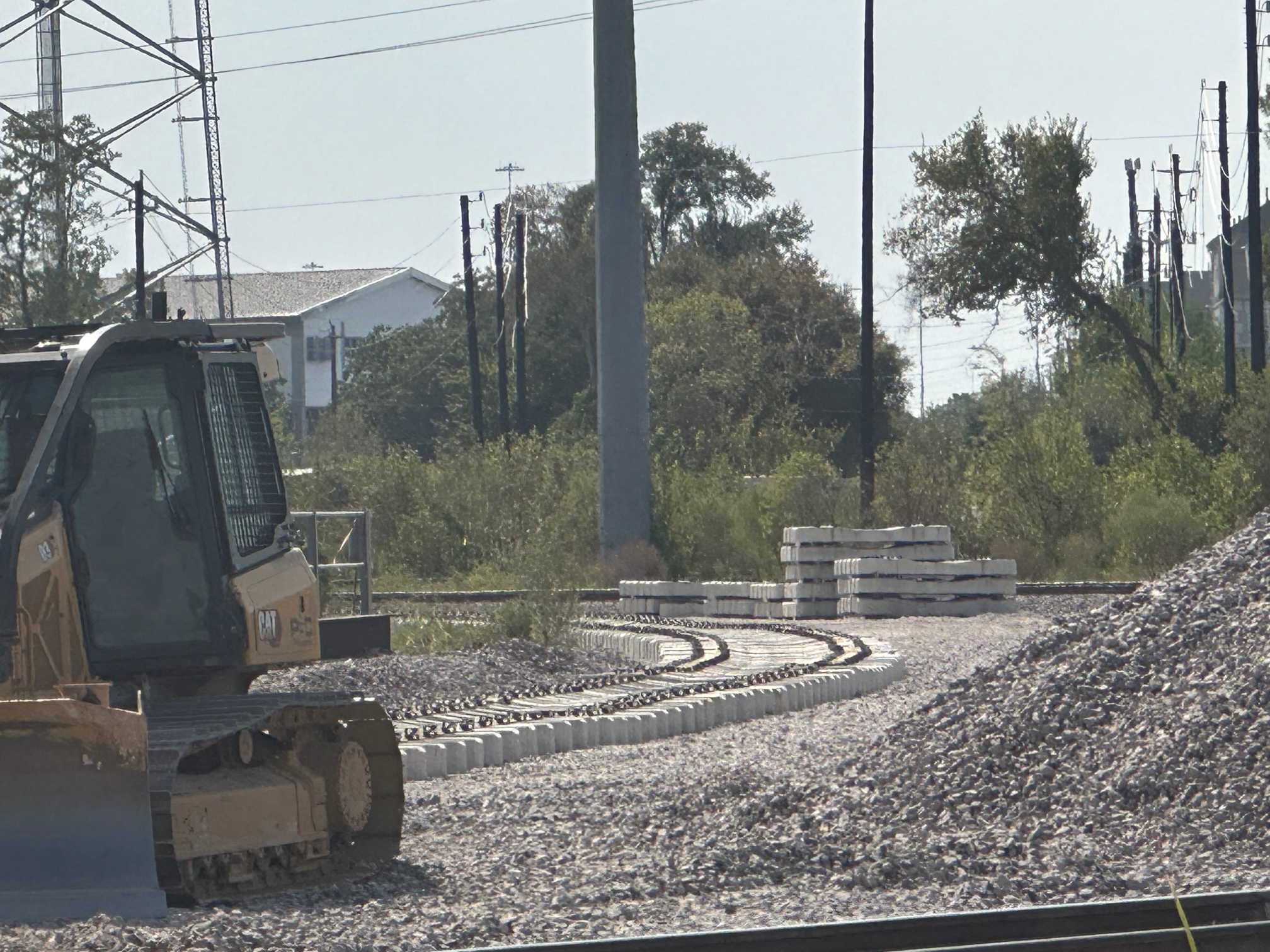
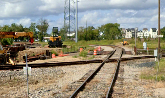
Restructuring the Track
Arrangement at Eureka Junction
Ed Johnson supplies the photos and updates from the
continuing construction work at Eureka Junction. A comprehensive comparison of
the prior track topology to the new arrangement will be provided when new Google
Earth satellite imagery is available. Currently, the most recent imagery date is
November, 2022, but significant changes have been accomplished since then and
the work continues.

Above: Click to enlarge these
photos from July 22, 2023. Ed comments: "Had looked like the crossing was a
past history but with all the work to widen Hempstead road to four lanes under
the UP, formerly SP and MKT; looks like we have a crossing back but will be used
by UP local out and into the yard, without backing in. Still not connected on
either ends nor progress to move the mains over to the new bridges to remove the
old bridge, so road widening can resume and finish."


Above: Click to enlarge
these photos from August 26 and September 1, 2023. Ed comments: "Kansas
Street lead tracks into Eureka Yard is complete and old road crossing removed.
New concrete ties being placed for mainline on new bridge since local tracks
were removed from bridge."