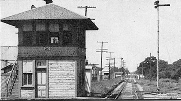
Texas Railroad History - Tower 30 - Harrisburg
Crossing of the Galveston, Harrisburg & San Antonio, the
Galveston, Houston & Henderson, and the Galveston, Houston & Northern railroads
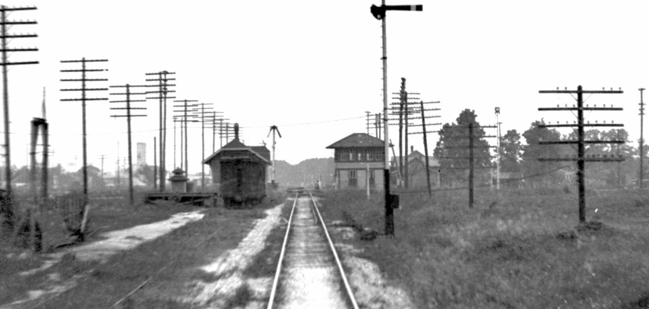
Above: Railroad executive John W. Barriger
III took this photo of Tower 30 from the rear platform of his private railcar as
his train proceeded north through Harrisburg on Galveston, Houston & Henderson
(GH&H) tracks. The date is unknown, probably in the mid to late 1930s. Barriger's view is to the south with Southern Pacific (SP) tracks
crossing in front of the tower from this angle. Faint indications of
trackside signals in the distance are likely associated with a southeast
quadrant interchange track that connected the GH&H to SP's line. The Harrisburg
GH&H depot sits to the left, across the tracks from the tower,
but Barriger's view of it is mostly obscured by a caboose parked on a side track
next to a loading platform. (image courtesy John W. Barriger III National
Railroad Library)
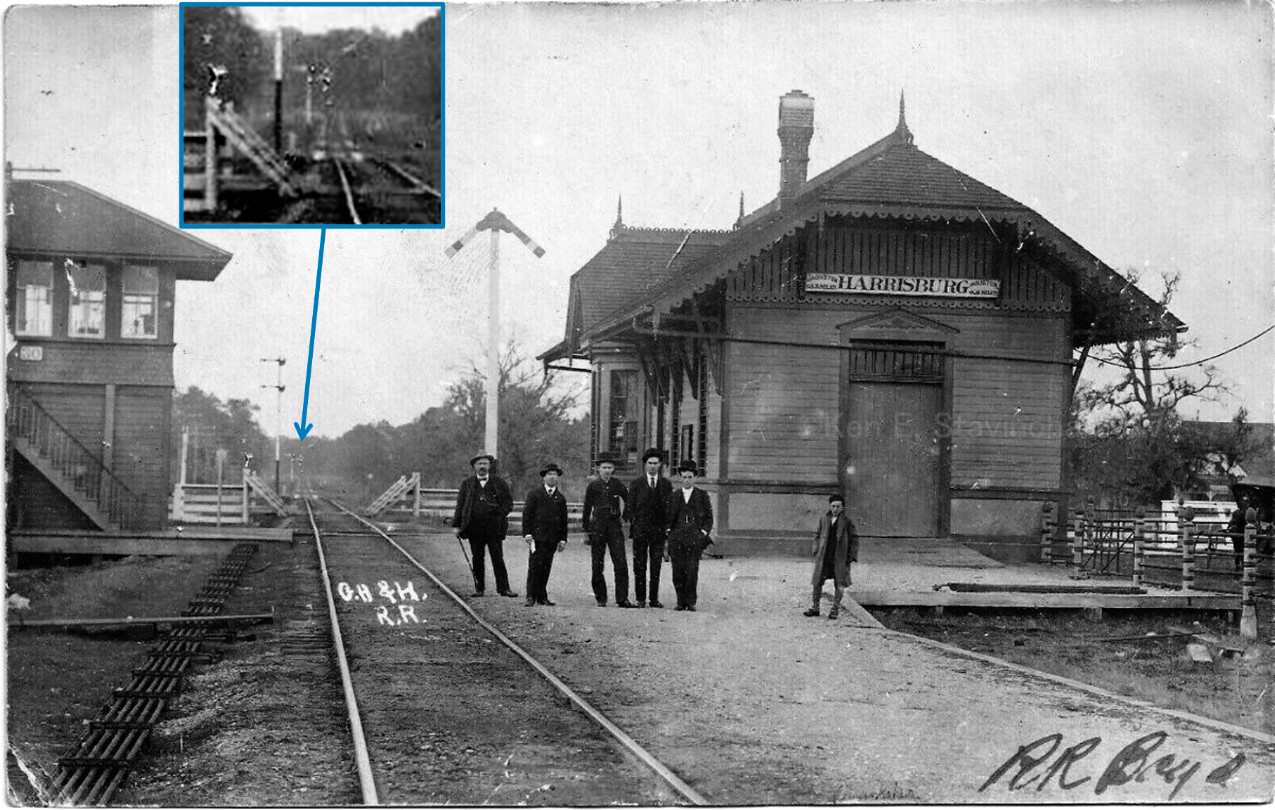
Below: This excellent 1908
photo (Ken Stavinoha collection) faces north showing that (approximately) three
decades earlier, the scene was much the same, though from the opposite direction
(e.g. compare the semaphores in both images.) In this view, the SP tracks cross behind the
tower and the depot. The blue inset shows signals on the GH&H north of the crossing
that are probably for a connecting track from the SP line west of the tower that crossed the GH&H to reach
another SP track parallel to (and east of) the GH&H.

Above Left:
This undated photo of the GH&H depot at Harrisburg faces northeast showing
the west and south sides of the depot. (Kenneth Anthony collection)
Above Right: This
photo faces west on SP's tracks with the GH&H crossing in front of Tower
30. It appeared in the May - June 1951 edition of
SP Bulletin, a publication of SP's Texas & New Orleans Railroad (courtesy David Milton
collection.)
The tower's architecture confirms it was
built by SP, resembling many other towers built by SP in Texas (e.g. Tower 81
three miles to the west.)
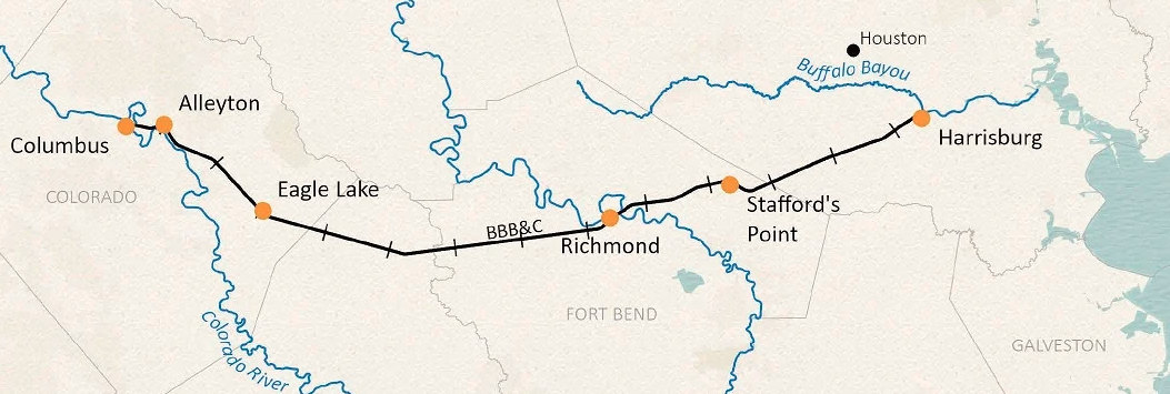
The Buffalo
Bayou, Brazos and Colorado (BBB&C) Railway was the first railroad in Texas. Chartered in February, 1850, it started construction in 1851
at Harrisburg, a
riverport on Buffalo Bayou southeast of Houston
to which steamboats could navigate from the Gulf of Mexico. Though it took two
years to lay twenty miles of track west to Stafford,
by the summer of 1853 the BBB&C was
advertising round trip service between Harrisburg and Stafford. The BBB&C
eventually resumed westward construction toward the Brazos River a dozen miles
away. The arrival of tracks into
Richmond on the west bank of the river
prompted a huge public celebration held on January 30, 1856. Quoting the
Richmond Sun, the
Galveston Commercial of January 24th reported that former President of
the Republic of Texas, Mirabeau B. Lamar, "...has been chosen the orator of
the day...", a day that would include "...a complimentary Dinner to those who
have been prosecuting the work...". The article anticipated a big event,
noting that "...from five to ten thousand persons are
expected to be present." BBB&C construction eventually resumed from Richmond with the tracks
passing through
Eagle Lake in 1859. Work stopped at Alleyton
across the Colorado River from Columbus in late 1860. No further progress was made during
the Civil War.
Right: BBB&C map, Texas General Land Office
The Civil War wrecked the economy,
causing the BBB&C to default on its construction financing. A
major landowner along the route,
Thomas Peirce, led an investor group that
acquired the BBB&C in 1870. Peirce rehabilitated the railroad and renamed it the Galveston, Harrisburg &
San Antonio (GH&SA) Railway. He laid tracks from Columbus to
San Antonio, and extended the line west to El Paso
at SP's behest. SP leased and
then acquired the GH&SA in the 1880s, and it became a major component of SP's
southern transcontinental railroad between Los Angeles and New Orleans. |
 |
Shortly before the Civil War,
the Galveston, Houston & Henderson (GH&H) Railroad laid its
first tracks, bridging
Galveston Bay and building
north from Galveston to Houston. The GH&H crossed
the BBB&C at Harrisburg less than a mile west of Buffalo Bayou, creating the first major
railroad junction in Texas. Like the BBB&C, the GH&H became insolvent during
the Civil War. It went into receivership in 1867 and was acquired out of
bankruptcy in 1871. A decade later, the GH&H was purchased by
rail baron Jay Gould in August, 1882, and soon thereafter, he sold it to the Missouri, Kansas & Texas (MK&T, "Katy") Railway
of which he was President. A year later, Gould directed the Katy to lease the GH&H to the International & Great Northern
(I&GN) Railroad, Texas' largest, which he had acquired in 1881. The
I&GN had a presence in Houston whereas the Katy
did not. The Katy main line between Fort Worth and Laredo was complete, but
construction of a secondary main line from Taylor
to Houston via Smithville had not yet begun and
wouldn't until 1886. Even then, limited construction progress was made due to
legal, political and financial problems that descended upon the Gould empire
in the latter 1880s. Gould was fired by Katy stockholders in 1888, but he
retained ownership of the I&GN. In 1895, three years after his death, Katy
tracks finally reached Houston and connected with the GH&H. The Katy tried to
cancel the I&GN's lease of the GH&H, but Gould's son George, who had succeeded
his father as I&GN President, countered with a lawsuit. The dispute was eventually settled splitting the GH&H
between the Katy and the I&GN, both railroads having half-ownership of the
GH&H and unlimited use of its tracks and facilities.
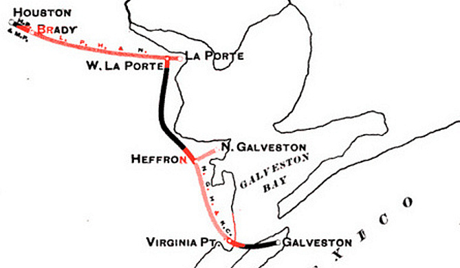
Around the time
of the Katy's arrival into Houston, the Galveston, La Porte and Houston
(GL&H) Railway was laying tracks through Harrisburg. The GL&H had been
founded to consolidate three smaller railroads and build tracks to connect
them, establishing a complete rail line between
Houston and Galveston. The GL&H planned to build its own rail bridge onto
Galveston Island, joining the GH&H and the Gulf, Colorado & Santa Fe (GC&SF) Railway
which each had their own bridge.
Unlike the GH&H, Santa Fe's route out of Galveston did not go directly to Houston;
it served downtown Houston on a branch line off its main track at
Alvin. The GL&H's planned rail line along the coast through La Porte, Seabrook
and Texas City would effectively parallel the GH&H
tracks, but farther east along the coast.
In addition to the Galveston Bay bridge,
the GL&H planned to build a bridge over Buffalo Bayou
at Magnolia
Park several miles east of downtown Houston. This was an important component
of its plan because it would facilitate a rail line directly to
Galveston from the north side of Buffalo Bayou. The north side was an industrial area served by
several SP railroads, hence the GL&H hoped to become an attractive
acquisition target for SP. The
direct route would eliminate SP's need to send Galveston traffic through
downtown Houston. While SP waited to see what might materialize, the GL&H went
into receivership in early 1896 before it had finished either bridge. The bankruptcy court allowed the Receiver to
sell $250,000 in Receiver Certificates to pay the GL&H contractor to complete
the bridges and additional tracks, which was accomplished by mid 1896.
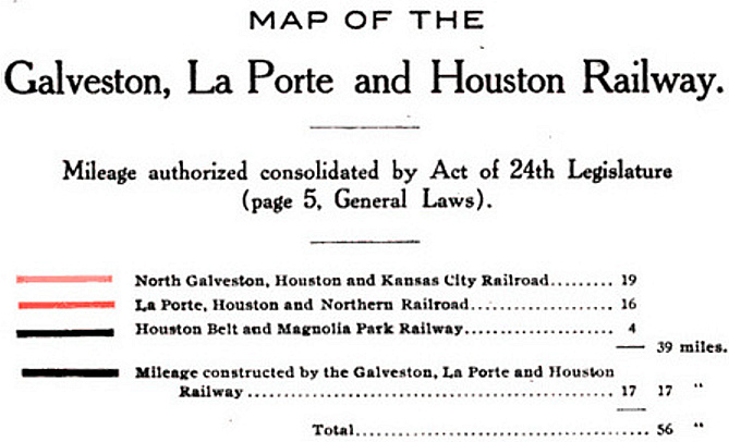
Above: This map appears in
the book Railroad Consolidations in Texas 1891 -
1903 by Joseph Draper Sayers published in 1903. It illustrates how
the GL&H was formed as a consolidation of three railroads into Houston.
Harrisburg is not shown on the map. It is located east of Brady on a right-of-way
(ROW) originally surveyed by the La Porte, Houston & Northern (LH&N) Railway.
L. J. Smith had been the GL&H construction
contractor and he held extensive debt against the railroad for unpaid bills. In
October, 1898, Smith won a court-ordered auction, enabling him to buy the GL&H
out of foreclosure for $425,000.
(It is likely that much of Smith's money came back to him in distributions from
the creditor's committee since he held the largest debt.) In April, 1899, Smith
sold the GL&H to the newly chartered Galveston, Houston
& Northern (GH&N) Railway of which he was a Director. Less than a
year later, the GH&N was sold to SP. Eight months after the sale, the GH&N
(GL&H) bridge onto Galveston Island was wiped out by the
massive hurricane that struck on September 8, 1900. Only the Santa Fe
bridge survived the hurricane and it became a critical link in rebuilding the
island. In the aftermath, the decision was made to build a
single concrete causeway across Galveston Bay to be
shared by vehicular traffic, steam railroads and an electric interurban.
Construction commenced in 1909 and the causeway opened in 1912.
SP intended to merge
the GH&N into the GH&SA, but this was delayed until 1905 because it required
approval by the Texas Legislature. In 1927, SP's railroads in Texas and Louisiana
including the GH&SA were leased to the Texas & New Orleans (T&NO) Railroad
which became SP's principal operating railroad in the two states. In 1934, the GH&SA
became fully
merged into the T&NO.
Prior to acquiring the GH&N, SP determined
that it needed another bridge over Brays Bayou at Harrisburg. Its GL&H
bridge went northeast into Magnolia Park, but SP wanted a bridge to
the Port of Houston north of Harrisburg on the south (west) bank of
Buffalo Bayou. The bridge was approved by the Secretary of War on
January 13, 1903 but it was not built. In 1915, SP built a 50 ft.
plate girder lift bridge at the mouth of Brays Bayou, improving port
access from Harrisburg since SP trains no longer had to use the GL&H
bridge to circle around the north side of Magnolia Park.
In 1917, the City of Houston issued a Request for Proposal (printed
in Texas
Trade Review) for a 4-mile electric transit railway between the
Port of Houston and a Sinclair refinery east of Harrisburg. The line
would serve population centers at Harrisburg and La Porte that supplied
most of the employees for these industries. For the transit line, a new bridge over Brays
Bayou was built about 750 ft. upstream from SP's lift bridge. SP's GL&H bridge was a half-mile
further upstream, and the
GH&H bridge was another 275 yards beyond the GL&H bridge. Between 1957 and 1962,
the lift bridge at the mouth of Brays Bayou was dismantled and SP began using the electric railway bridge
(no longer in use for transit.) This enabled SP to abandon the GL&H bridge c.1965.
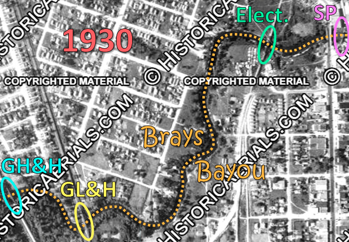
Among the
four railroad bridges over Brays Bayou within the first mile of its
confluence with Buffalo Bayou, the GH&H bridge was the earliest
constructed, in the late 1850s. The last to survive are the GH&H bridge
(rebuilt) and the electric railway bridge (likely rebuilt) which remain in
service by Union Pacific (UP), successor to SP.
Left: The four known
rail bridges over Brays Bayou near Harrisburg existed simultaneously in
this 1930 aerial image ((c) historicaerials.com.) |
 |
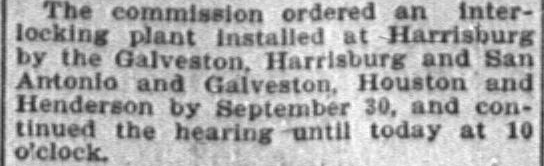 |
Left: This
news item in the
Austin Statesman of June 17, 1903
reported on an order issued by the Railroad
Commission of Texas (RCT) to interlock the junction at Harrisburg. The
railroads did not meet the September 30 deadline.
On December 31, 1903, RCT commissioned Tower 30 as a
24-function mechanical interlocker to control the rail junction at
Harrisburg. The GH&H, GH&SA and GH&N were listed as the railroads
involved; RCT annual reports dropped references to the GH&N after it was
merged into the GH&SA in 1905. In 1916, RCT began listing the railroad
responsible for operating each tower. For Tower 30, it was the GH&SA
which is
unsurprising since SP built the tower. |
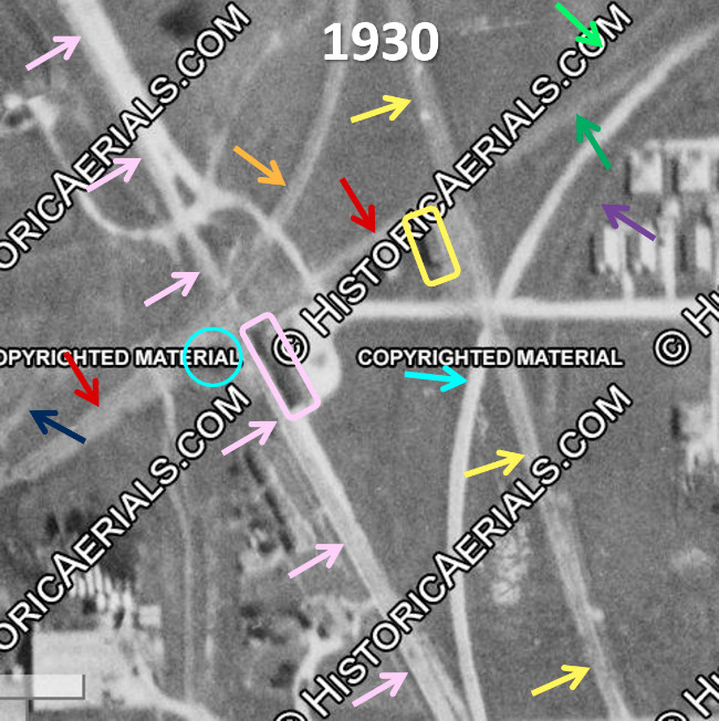 |
Left:
This 1930 aerial image ((c) historicaerials.com) shows where the GH&H,
the GH&N and the GH&SA formed the junction that was
controlled by Tower 30.
Tower 30 (light blue circle,
obscured by the copyright notice) sat across from the GH&H depot (pink
rectangle) in the south quadrant of the 'X'-pattern GH&SA / GH&H
crossing. The junction was a quarter mile south of Brays Bayou and
three-quarters of a mile southwest of Buffalo Bayou. The GH&H (pink
arrows) had a NNW / SSE alignment through Harrisburg generally parallel
to SP's GH&N tracks (yellow arrows) about a hundred yards to the east.
From the west, the SP
(GH&SA) tracks (red arrows) enter the area on a NE heading and cross the
GH&H and SP (GH&N) lines roughly a hundred yards apart. East of the SP depot (yellow
rectangle) the GH&SA splits. One branch (light green arrow) passes beneath an electric transit railway farther
east
and proceeds northeast to the lift bridge at the mouth of Brays Bayou. The other
branch (green arrow) merges with a GH&H connecting track (light blue arrow)
and then curves due east for a short distance before turning south. It
eventually merges into the SP (GH&N) main line (yellow arrows) to La Porte and Galveston.
That line curves southeast off the bottom of the image
to head toward La Porte.
There are three additional connecting
tracks visible in this image. Two SP connectors (orange arrow and purple
arrow) provided routes between the GH&SA and GH&N tracks. There is
also a connector (dark blue arrow) between the GH&SA and GH&H that does
not appear to have been used frequently.
In 1927, RCT's Annual Report added
PTA as another railroad involved with Tower 30. PTA was an
abbreviation for
the Port Terminal Railroad Association (PTRA) which had been created in 1924 to
develop coordinated
rail access among the railroads at the Port of Houston and build new
tracks where necessary. PTRA's specific involvement with Tower 30 in
1927 in undetermined, but it probably pertained to remote control of
switches and signals along the port. |
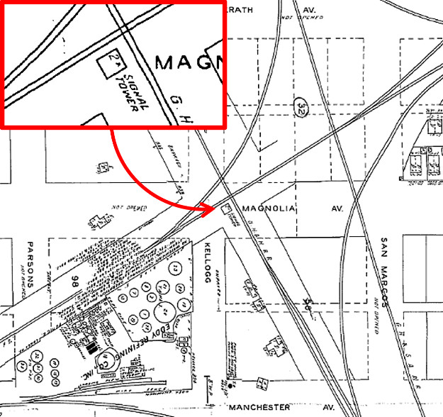
Right:
Tower 30 is the 2-story "Signal Tower" in the center of this snippet from the
1951 Sanborn Fire Insurance Map of Houston.
Below: This T&NO track chart of Harrisburg (Carl
Codney collection) is not drawn to scale and does not show Brays Bayou,
but it otherwise conveys SP's track layout near Tower 30 as of 1926. The
Magnolia Warehouse was north of Brays Bayou and was served from the
north by the I&GN through Magnolia Park. SP's main line continues to
Galveston off the lower right side of the image, and the branch there
"To Manchester Industries" went mostly east, not north. Ultimately a
direct connection was made between the port tracks and the track labeled
"Branch" to create a new main line to the port via the electric railway
bridge. The line continued to Tower 86 on
the north side of Buffalo Bayou allowing SP's GL&H bridge over Brays
Bayou to be removed.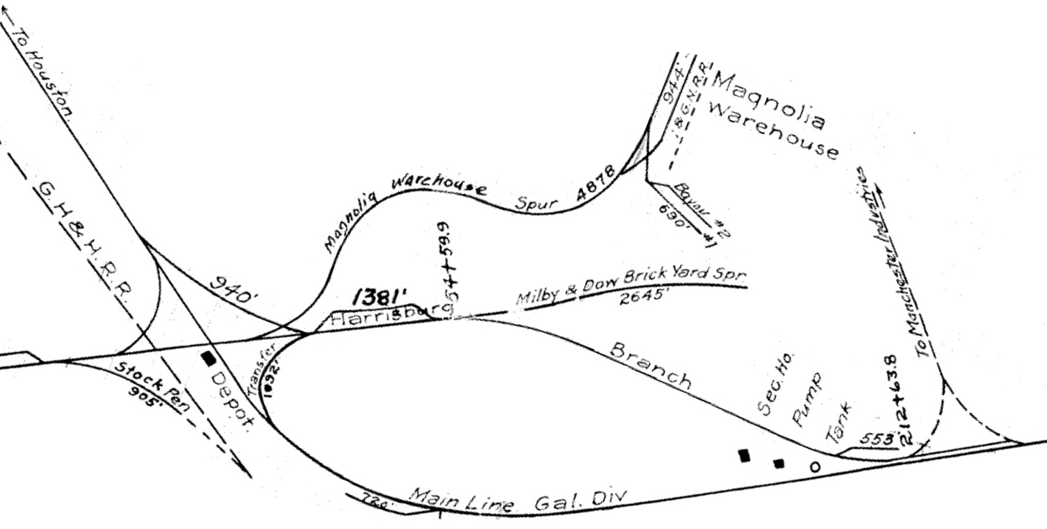 |
 |
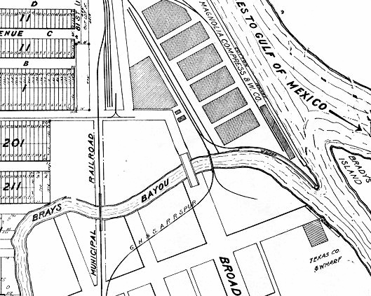
Right: This snippet from a 1918 map of Magnolia
Park shows the Municipal Railroad electric railway line and its 1917
bridge over Brays Bayou. Downstream, the GH&SA spur to the Magnolia
Compress and Warehouse Co. crosses Brays Bayou on SP's 1915 lift bridge
near the mouth of the bayou, about 80 yards downstream from the bridge
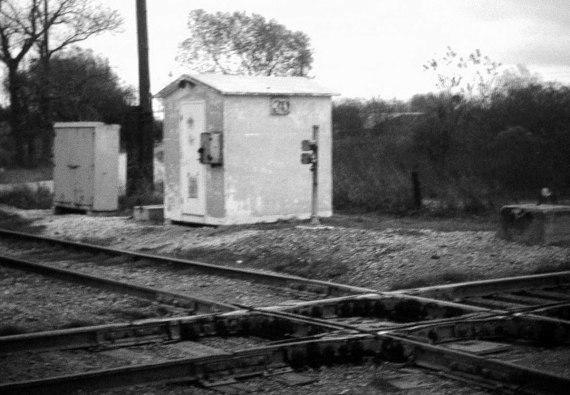
for Broadway. Below:
Around
1965, this concrete hut was
installed to house the Tower 30 automatic interlocking plant that
replaced the two-story tower. This style of hut was
common among Texas interlockers. Override
controls for the interlocker are mounted on the pole beside the hut. The fate of the Tower 30
building is undetermined. (Greg Johnson photo, 1969)
 |
 |
In 1922, the I&GN emerged from receivership with a new
name, International - Great Northern (I-GN) Railroad. It was acquired
by Missouri Pacific (MP) in 1925, hence the GH&H's ownership was split
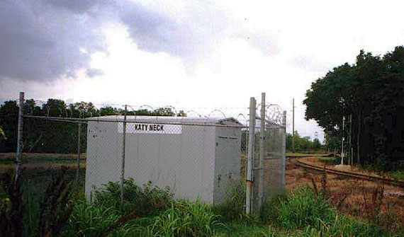
between the Katy and MP. Over decades of Katy activity through Tower 30, railroaders
gave the crossing a nickname, Katy Neck, a term still used. In 1988, the Katy
was acquired by UP and merged into MP, which had been acquired
by UP in 1982. This gave UP full ownership of the GH&H, which was dissolved
and merged into
MP. SP was acquired by UP in 1996, and SP and MP became
merged into UP, hence all
lines crossing at Katy Neck are now owned by UP.
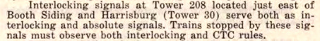
| Right:
This excerpt from SP's 1969 Special Instructions #4 references both
Tower 30 and Tower 208. Tower 208 was located along the south bank of
the Ship Channel near SP's GL&H Buffalo Bayou bridge on the north
side of Magnolia Park. When Tower 208 was established in 1957, it was
remote-controlled from Tower 30. |
 |
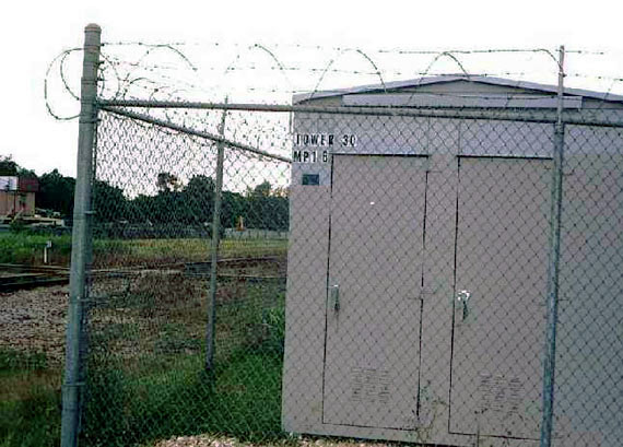
Above Left and Right:
The Tower 30 interlocking electronics were relocated from the concrete
hut to this equipment cabin at an undetermined date. Satellite imagery
in 2023 shows the concrete hut still standing, presumably abandoned
although it could be used by UP for materials and equipment storage. (Jim King photo, 2005)
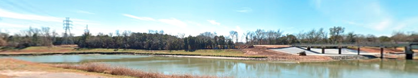
Above: Looking north toward Tower 30
from the south bank of Brays Bayou, the power lines at left mark the SP
right-of-way and the site of the GL&H bridge. UP's rebuilt GH&H bridge is at
right. The Brays Bayou channel was widened many years ago to improve flow and
reduce flooding and erosion. Below: This
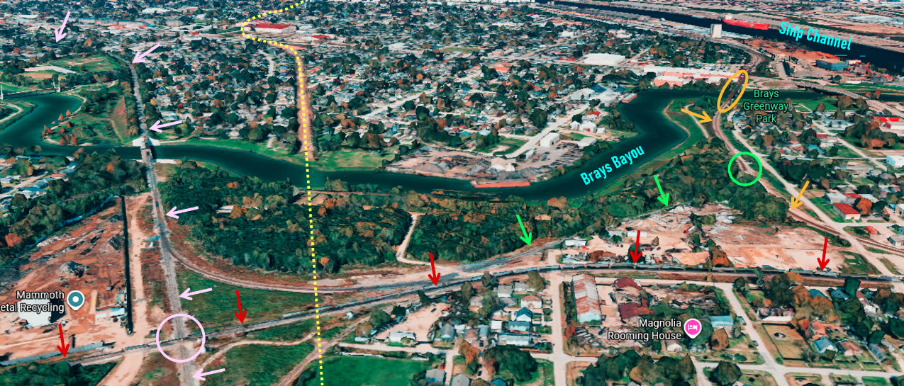
north-facing Google Maps 3-D
perspective of Harrisburg shows the proximity of Tower 30 (pink circle) to Brays
Bayou and the Houston Ship Channel. UP's former GH&H line (pink arrows) turns
west after crossing Brays Bayou and continues through
Tower 85 into downtown. Houston. SP's former GL&H right-of-way (yellow
dashes) now carries power lines and is more apparent north of Brays Bayou.
Railcars are visible on the east / west GH&SA line (red arrows.) The electric railway
bridge (orange oval) provides UP's primary access to the Port of Houston. The
rail line south from the bridge (orange arrows) connects (green circle) with a
spur (green arrows) to UP's east / west tracks. Farther south, the two main
lines (orange arrows and red arrows) merge to continue east to serve the
enormous array of petrochemical plants along the waterway at La Porte and
farther south. The GH&H route supplies UP's main line to Galveston, so the
former GL&H route through La Porte no longer reaches Galveston. It
terminates immediately south of a
rail-served facility owned by Geon Performance Solutions, LLC in Seabrook.