Texas Railroad History - Tower 138 - Harlingen
A Crossing of the Missouri Pacific and Southern Pacific
railroads
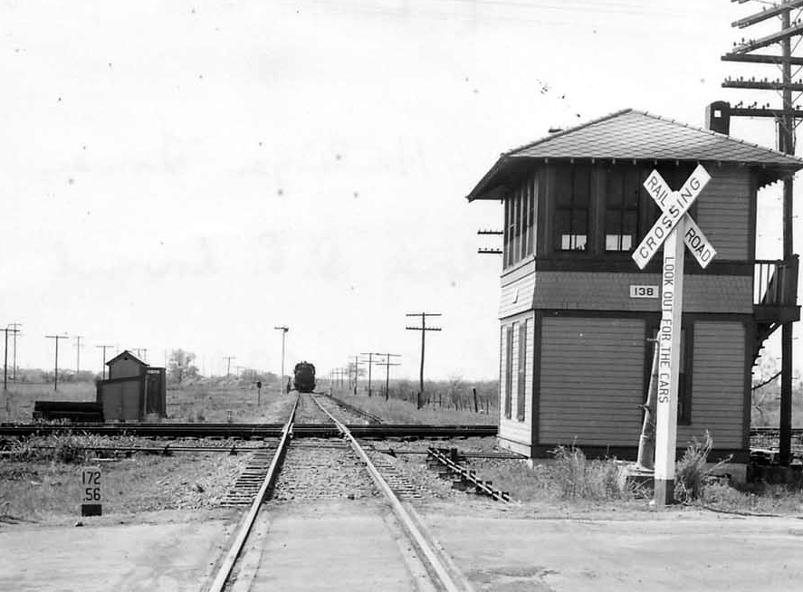
Above Left: This 1944 photo of Tower
138 shows that it was a typical Southern Pacific (SP) two-story structure
resembling many other SP towers in Texas. SP's chosen architecture had remained
essentially unchanged over a quarter century, e.g. compare Tower 138 (opened
September 28, 1928) with Tower 26 (opened September
29, 1903.) This photo looks west down
the SP tracks toward Edinburg, with an approaching
SP train paused at the home signal exhibiting a stop condition (horizontal
semaphore blade.) Tower 138 sat in the northeast quadrant of the crossing, with
two tracks of the Missouri Pacific
(MP) Railroad crossing north / south, behind the tower from this angle. (R. H.
Carlson photo)
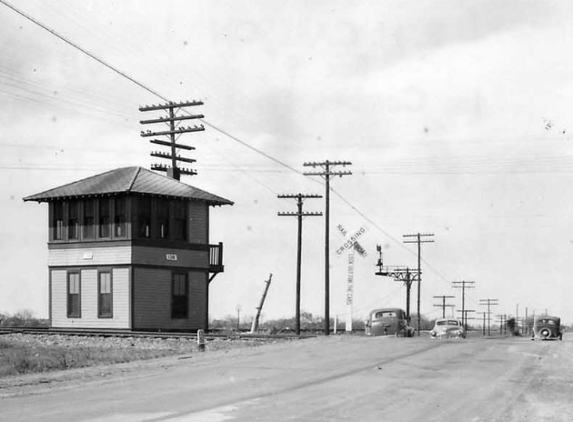
Above Right: This
photo, also taken by R. H. Carlson on February 29, 1944, shows the
southeast corner of the tower. A leaning metal pole set in concrete is
visible in both photos between the tower and the cross buck. The pole has
appendages that look similar to what might be expected for a large swing gate,
but the location is not near the diamond where a gate would have been placed.
Since the concrete base does not appear to be sunk into the ground, perhaps the
pole had simply been moved away from the diamond when the tower was erected. The size of the pole is
comparable to the swing gate pole at Tower 176, but
such poles would not normally be bent.
(photos courtesy of The Jernigan Library South Texas Archives)
Harlingen was founded through the efforts of Lon Hill,
a lawyer and developer who served as the District Attorney for Bee County in the
late 1890s. Envisioning significant growth opportunities for the Rio Grande
Valley, Hill procured large tracts of land in Cameron County and operated a rice
plantation near Brownsville, along with other
commercial ventures. Hill began to pursue railroad service into the Valley and he led a committee that raised a bonus to
be given to the first railroad to reach Brownsville. B. F. Yoakum's Gulf Coast
Lines (GCL), under the charter of the St. Louis, Brownsville and Mexico (SLB&M)
Railway, collected the bonus by constructing a line from
Robstown to Brownsville in 1904, a distance of 141
miles. Robstown was on the national rail network via Texas Mexican Railway
connections to both Corpus Christi and Alice where
rail lines to San Antonio and
Houston could be accessed. Twenty-five miles north of
Brownsville, the SLB&M passed through a clearing on Lon Hill's land that he
had designated to be the future town of Harlingen, named for a Dutch city. Hill personally guaranteed
free right-of-way plus an additional land bonus if the railroad also built a
westward branch to Starr County. The SLB&M did so with a forty mile line that
terminated in what is now the city of Mission, passing through locations that
would prove to be excellent for agricultural development. As Lon Hill had
planned, the town of Harlingen sprang up in his clearing, becoming an
incorporated city in 1910.
While numerous short branch lines were built, no other major railroad came into the
Valley for two decades. In a 1903 legal battle, Southern Pacific (SP)
had
lost control of the San Antonio & Aransas Pass (SA&AP) Railway
which prevented SP from building toward the Valley. It also left the SA&AP
independent, but with insufficient resources to continue
its own construction toward the Valley from its southernmost rails at Falfurrias.
As this greatly benefited
B. F. Yoakum, SP accused Yoakum of being the hidden mastermind behind the legal
issue through his friendships with the commissioners of the Railroad Commission
of Texas (RCT). Yet SP had admitted that the control it was exercising over the SA&AP was illegal,
as RCT had charged. SP didn't even take it to court, instead negotiating a
settlement with RCT in which the SA&AP stock held by SP was cancelled and
forfeited, but allowing the SA&AP to retain its state charter as an independent
railroad. From Brownsville, Yoakum's SLB&M
reached
Houston via Algoa in 1908, remaining the only
connection out of the Valley to the national rail network until 1926.
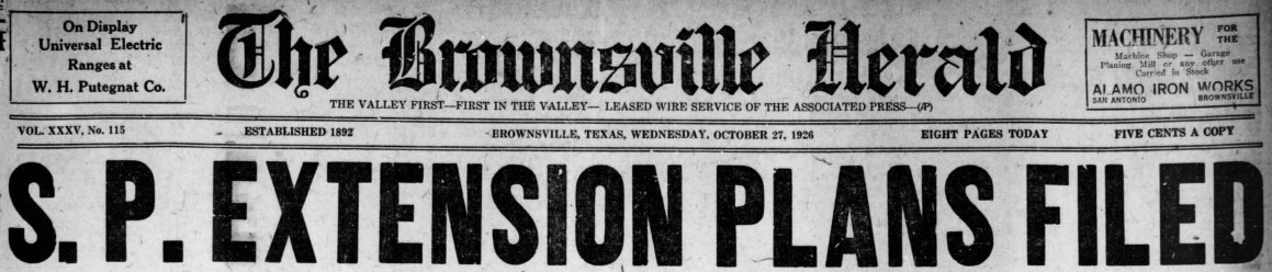
Above: SP's plan to build from
Harlingen to Brownsville was BIG NEWS in the Brownsville Herald
of October 27, 1926. The announcement came less than a year after SP was able to
reacquire the SA&AP and resume construction south from Falfurrias. By then, the SLB&M had come under the
ownership of the large Missouri Pacific Railroad (MP), and the two railroads would compete
vigorously for Valley business in the years to come.
A year later, the Brownsville Herald of
November 13, 1927 carried a lengthy article about SP's
rapid advance into the Valley. It cites January 11, 1927 as the date
that the track from Falfurrias to Edinburg was completed. It notes that SP passenger service to Edinburg began February 6, 1927, but that
the line from Edinburg to Harlingen "had been completed before that
date." SP's urgency to serve the Valley had motivated
deployment of multiple construction crews so that service to Harlingen could
commence practically as soon as the Falfurrias - Edinburg track had opened. The
Interstate Commerce Commission (ICC) approved SP's plans for the Brownsville
extension on May 24, 1927. Construction began at Harlingen on June 30th;
it was "rushed with all possible expedition" and completed
to Brownsville within four months.
 |
Left and Right:
Brownsville Herald, October 26, 1927
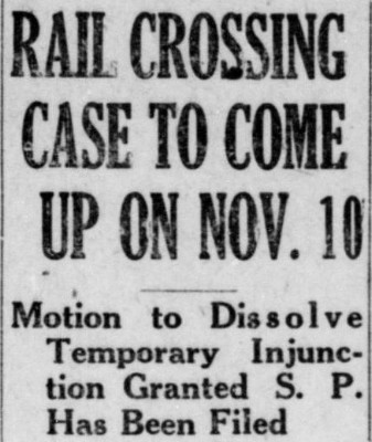
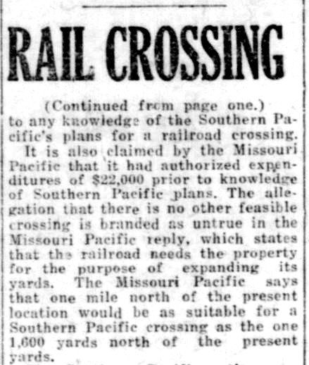
In the same
October 27, 1926 issue of the Brownsville Herald
that produced the massive headline above, another article revealed that
the location of the future Tower 138 crossing was the subject of a
serious dispute between MP and SP. This dispute may also help to
explain a curious aspect of SP's route into Harlingen. On October 16,
1927, a judge in Harlingen had granted a temporary restraining order requested
by SP that prevented MP "...from running trains over certain tracks
on property claimed..." by SP. SP believed it had
acquired an option to purchase three acres near MP's yard which it intended
to use as the location for the grade crossing over MP's tracks. MP
claimed that prior to its awareness of SP's option, it had authorized
$22,000 to procure the land directly from the owner, W. H. Neu, a
resident of the tiny community of Lindsey six miles west of
Gainesville
near the Red River. Perhaps due to communications issues or mail delays,
both railroads thought they had control of the land. MP wanted it to expand its yard
while SP planned to use it to cross MP's tracks. SP asserted there was no
other feasible crossing location while MP responded that
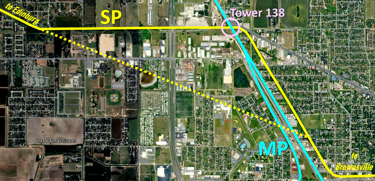
a site a mile farther north would be suitable. The Google Earth
image below has been
annotated to show that less than two miles from Harlingen, SP's tracks
turned due east to proceed across the MP tracks and then turn south.
With rural, unpopulated land available for its right-of-way, there is no
obvious reason for SP to have planned this jog to the east and then
south. Projecting a route (yellow dashes) onto SP's approach angle
surmises a crossing about where the disputed property was located.
Apparently, a settlement ensued or perhaps SP simply lost its case. |
 |
SP's plans for a Brownsville extension were submitted
in October, 1926, but SP did not receive ICC permission until May 24, 1927 and
the construction work did not commence until June 30. Presumably, well before
then, the crossing site had been settled, but it is not known for certain when
SP actually built across the SLB&M tracks. Since RCT
authorized Tower 138 to begin operating in September, 1928, there was
most likely a
period of 12 to 15 months where the diamond was uncontrolled.
This lends credence to the idea that the metal pole visible in the
photos might have been used for a gate prior to Tower 138's opening (but
if so, why was the pole still sitting near the tower sixteen years later?)
A gate would have allowed trains to approach the crossing at restricted
speed and continue across the diamond without stopping if the gate was
visibly open.
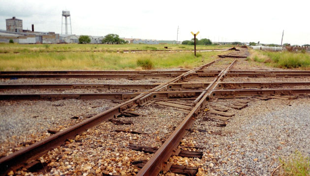
A news item in the January 7, 1928 issue
of Railway Age listed Harlingen as a planned
location for SP to install an 18-function mechanical interlocker during the
upcoming year. By
the time Tower 138 opened on September 28, the function count had grown to
30 according to a table published by RCT at
the end of the year. Two years later, RCT published a table showing the count
had dropped to 20, but this was the final comprehensive table of active
interlockers that RCT ever issued.
Tower 138 was one of the last 2-story interlocking towers
built in Texas. Tower 159 in Mathis opened in
November, 1929 as the final 2-story interlocking tower built in Texas (Tower
199 opened at Settegast Yard in Houston in 1952, but the interlocking was a
secondary feature of what was essentially a multi-story yard tower.) Improvements in
remote control technology and consolidation
of rail networks (and associated line abandonments) reduced the need for
manned towers, particularly as automatic interlockers became
authorized by RCT
in 1930.
 |
As the second railroad at Harlingen, RCT rules required
SP to provide all capital funding for the tower and its interlocking
plant, including associated signals and derails. Although SP took the lead on designing and erecting
the tower, RCT records show that MP was the railroad responsible for
operations and maintenance (O&M) staffing. This was the rare case where the
railroad that designed the tower was not assigned initially to staff it. MP
likely
sought this arrangement since its main line was much busier than SP's branch line,
i.e. MP
had a stronger interest in fast, effective O&M. Staffing and materials
expenses would have been shared between MP and SP based on a weighted
function formula promulgated by RCT.
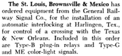
Left: The July, 1951
issue of Railway Signaling and
Communications carried this news item regarding the
installation of an automatic interlocking plant at Harlingen. Presumably
the installation was accomplished later that year or in early 1952,
resulting in the closure of Tower 138. The fate of the tower building is unknown. |
MP entered a lengthy receivership in 1933 that last
until 1956. It emerged from bankruptcy with a reorganization plan that dissolved
the SLB&M and other MP subsidiaries, fully integrating their assets into MP
operations. MP remained independent until 1982 when it was acquired by Union Pacific (UP),
but it continued to operate as a subsidiary under its own name.
In 1979,
SP abandoned their main line into the Valley from Falfurrias to Edinburg in
favor of a trackage rights agreement to use MP's main line south from
Placedo. To facilitate continued access to
Brownsville by SP on its own track east from Tower 138, a connector was added in
the northeast quadrant of the crossing. By 1994, SP's trackage rights had rendered the
Tower 138 automatic interlocker unnecessary and it was removed, replaced by stop
signs. In 1996, UP acquired SP, which led to removal of the Tower 138 diamonds
in 1998 since all of the tracks belonged to UP. The Santa Rosa sugar mill --
eleven miles west on the former SP tracks -- continued to be served from
Harlingen using a reworked connector off the main line in the southwest quadrant. Randy Curlin explains the evolution of the Tower 138
crossing:
"In the early 1990s, the crossing was "simplified" with stop signs in order to deactivate the
signals [and interlocker.] Around
1975, SP had begun using the MP line so this crossing saw very light use for SP save for a
couple of locals and yard jobs. The diamonds (MP main and drill-yard lead) were
removed in 1998 to speed up operations in the area. The SP switch job was moved
to the MP yard and a worn out connector track allowed access to the Santa Rosa
sugar mill from the MP yard."
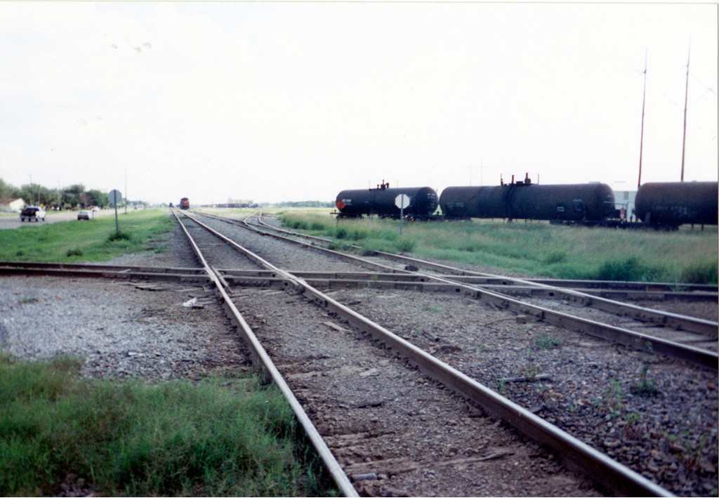 |
Left: Randy Curlin
describes this photo he took in June, 1998:
"This photo is looking south toward the MP Harlingen yard.
The main is the left track and the yard lead is the right track. The SP line
crosses
from left (Harlingen) to right (Edinburg). The backs of stop signs are visible
for northbound trains. Tank cars are sitting on the MP - SP interchange tracks.
The
connector track that allows southbound trains to access the SP line for
Brownsville is out of picture to the left." |
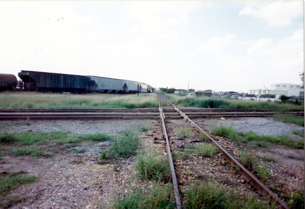
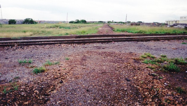
Right:
Compare this June, 1998 photo with the photo on the left at the top of page.
Randy
continues... "This photo is looking west on the SP toward
Edinburg. The nearest MP track is the main; the other is the yard lead.
Harlingen is to the south (left) and Kingsville is to the north (right).
It is strange that an SP yard limit sign is so close to the diamond.
Hopper cars are on the MP - SP interchange tracks."
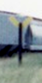
Below: yard limit sign
 |
 |
Above Left: By October, 1998,
UP had begun the effort to remove the former SP track across the UP main line.
To retain access to the SP line to the mill, the connecting track visible at
upper left would become the lead. Though not detectable from the photo, there
were actually two parallel connecting tracks that merged immediately prior to
reaching the switch onto the SP track. That switch was removed since there was
no longer a "straight through" track across the Tower 138 diamonds.
Above Right: By November,
1998, the SP track had been removed between the location of the connecting track
switch and the UP main line, which shows newer rails where the diamonds had been
located. Most likely, the SP rails had also been lifted back to the east (behind
the camera) to the point where they intersected the northeast quadrant connector
(purple arrows below) that enabled access to the former SP line to Brownsville. (Randy Curlin photos)
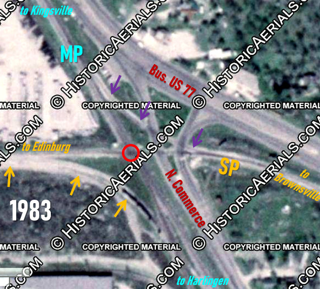 |
Left:
annotated 1983 aerial ((c)historicaerials.com) -- orange arrows:
connector to Edinburg; purple arrows: connector to SP Brownsville line; red circle: Tower 138 crossing
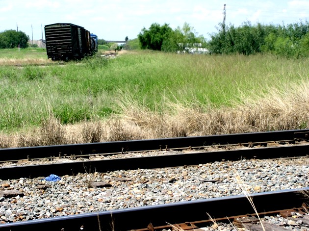
Above: Grasses have
overgrown the former SP right-of-way where the tracks to the crossing
were
removed. (Randy Curlin, September, 2004) |
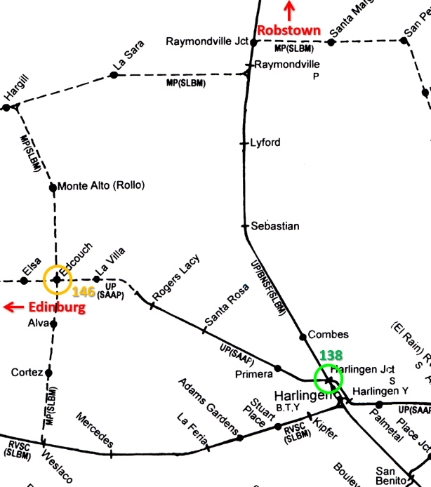
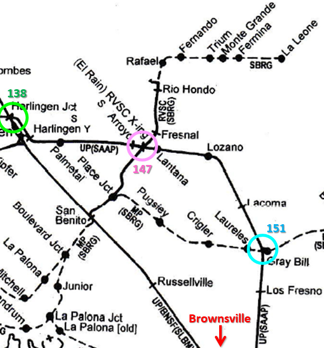
Above:
These two annotated maps showing the rail lines northwest (left)
and southeast (right)
of Harlingen have the Tower 138 crossing as a green circle, which can be used to align the
locations depicted. The maps are from the same source but have different
magnifications and thus different scales. They were published by Mike Walker in
the Texas component of his series Comprehensive
Railroad Atlas of North America ((c) Steam Powered Video, 2001.) When SP built to Brownsville in 1927, it crossed the MP
main at Harlingen and almost immediately began a curve to the right to begin a south-southeast
bearing toward Brownsville. SP's Harlingen yard was also eventually placed along
this track. But SP did not parallel MP's tracks all the way to Brownsville, preferring to
access new agricultural developments farther east near Lantana and Lozano before
turning due south. This resulted in some additional rail
grade crossings, and the colored circles depict the interlocker locations of
Tower 151 (Rosita) and Tower 147 (Lantana.)
Back to the west, Tower 146 (Edcouch) was also
established as were Towers 145 and 149 at Edinburg
(off the map to the left.) All of these were MP / SP crossings. The above maps
date to 2001, but UP had acquired and integrated virtually all of the railroads
in this area by 1997. Hence, UP is shown as the owner of most lines, with
predecessor companies in parentheses. Where "UP / BNSF" is shown, Burlington
Northern Santa Fe (BNSF) had acquired trackage rights from UP as part of the UP
/ SP merger in 1996. "SBRG" is the San Benito and Rio Grande Valley Railway
which did some early construction in the Valley a few years after the SLB&M had
arrived. The SBRG was acquired and merged into MP in 1925. UP has retained both
routes to Brownsville: the former MP main line, and the SP route that goes east
and then south. (Note that trackage rights changes and abandonments after 2001
may affect the accuracy of these maps.)
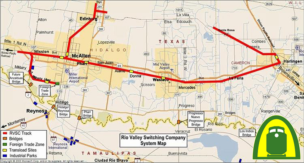
Below: The Rio Valley Switching Co. (RVSC) operates many of the
former MP and SP lines in this area including the former SP line westward out of
Harlingen toward Edcouch and Edinburg. This line now terminates just beyond
Santa Rosa where a sugar mill has been operating for 50+ years but has
recently closed down. In June, 1999, UP received permission from the Surface
Transportation Board to abandon the SP line between the outskirts of Edinburg
and the Santa Rosa sugar mill. The rails were removed in 2000 and the remaining
track east of the mill became known as the Santa Rosa Industrial Lead. (map
courtesy RVSC)
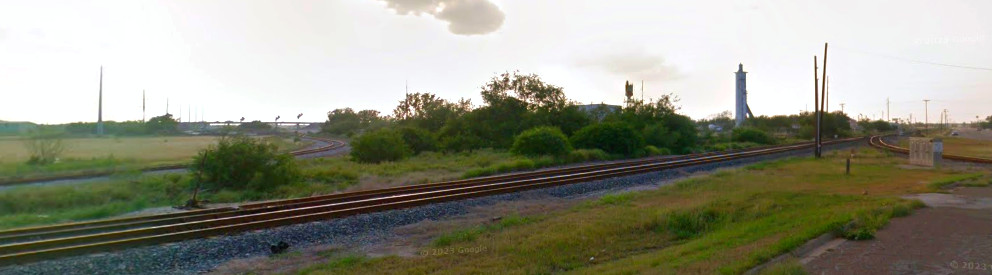
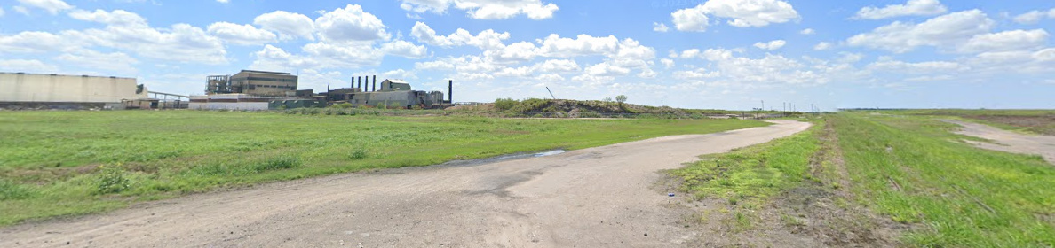
Above: The former southwest quadrant connecting track at Tower 138 is now the entrance to the Santa Rosa Industrial Lead which
runs just over ten miles to the northwest on the former SP tracks. The light
color pavement patch visible at far right provides the telltale sign of where
the SP tracks were removed in the autumn of 1998. This Google Street View from
is 2019; a 2023 Street View shows that N. Commerce St. has been completely
repaved. Tower 138 was located in the vicinity of the short pole in the vacant
area this side of the equipment cabinet.
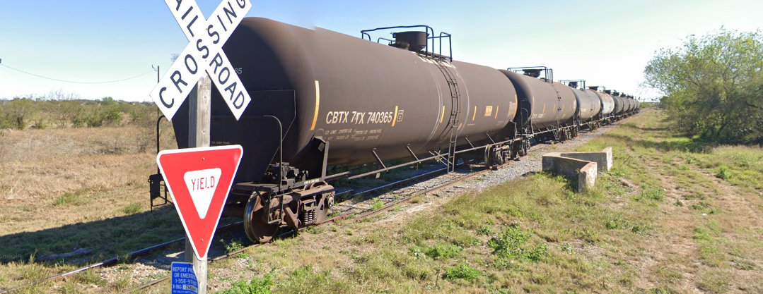
Below:
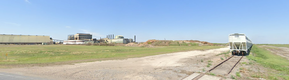
It's apparent from these tanker cars stored up to, but not crossing, Hand Rd.
that the Santa Rosa Industrial Lead was rarely in use in February, 2023 when
this Google Street View was captured. Another
string of tanker cars occupies the track in the opposite direction west of Hand
Rd. Although the sugar mill formally closed in 2024, production may have been
curtailed for a lengthy period, eliminating the need for rail service. Satellite
imagery from June, 2023 shows several cuts of tanker cars visible over a
two-mile stretch from Hand Rd. west to Burns Rd.
Above: In this April, 2021
Street View, hopper cars sit on the Santa Rosa Lead just shy of the switch to
the plant track for the sugar mill. Below:
By April, 2023, the Santa Rosa Lead appears to be out of service at the mill.