Texas Railroad History - Tower 173 - Palestine
A Crossing of the International & Great Northern (I-GN)
Railroad and the Texas State Railroad (TSR)
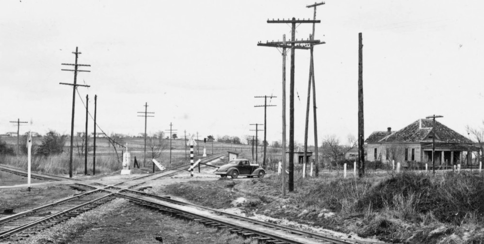
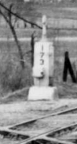
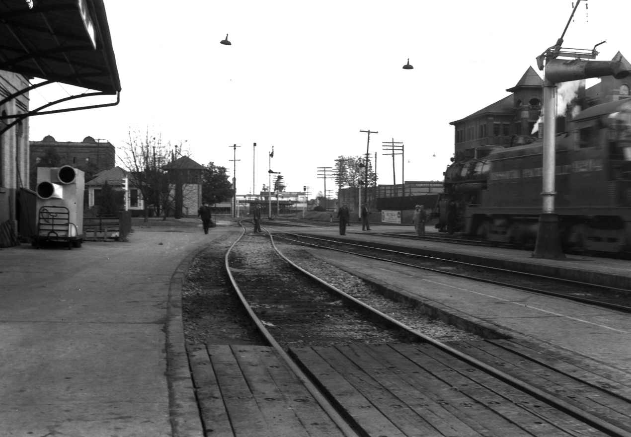
Above Left: This photo (courtesy Stuart Whitaker)
shows the Tower 173 crossing at Palestine taken sometime in the late 1930s or
early 1940s.
The automatic interlocking plant that governed this crossing was installed in
the trackside equipment cabinet visible directly beyond the diamond
(magnification above right.)
The smaller box mounted on the side of the cabinet was likely the override
controls that could be used by a train crewmember if the interlocker was
mistakenly withholding a "Proceed" indication on the home signal. The photo's
view is generally east; the vehicle heading south on S. Royall St. has just
crossed over the International - Great Northern (I-GN) main line to Houston. The
tracks crossing in the foreground belonged to the Texas State Railroad (TSR).
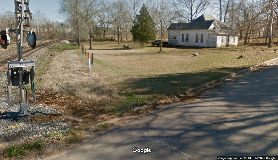
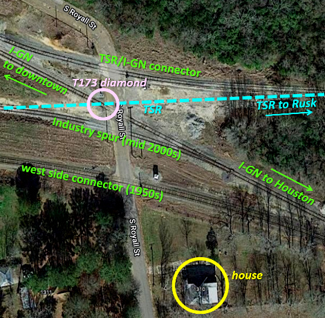
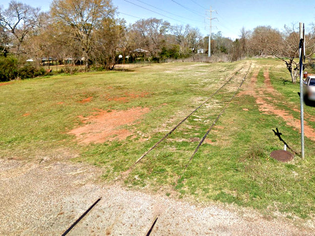
Below Left: This Google Street
View shows the same house in 2013. The camera is on S. Royall St., hence the
angle, distance and field of view are different compared to the above photo. The track
at the grade crossing is the "west side connector"
which did not exist in the earlier
photo. It merges (at the signal in the distance) into the I-GN
main line (which the vehicle in the above photo had just crossed.)
Below Right: The restructuring of the tracks at Tower173
eliminated the crossing diamond (pink circle), leaving the "TSR / I-GN connector"
as the TSR's only remaining connection to the national rail
network. The former TSR tracks to the west terminate as an industry spur
about 275 yards west of the former diamond.
The town of Palestine was established in 1846 at the
center of the newly formed Anderson County, eventually becoming the county seat.
The name derived from Palestine, Illinois, the hometown of Daniel Parker, a
prominent religious leader who had settled in the area. Palestine experienced a
flurry of rail construction in 1872-73, and by the late 1870s, it was the
headquarters of the International & Great Northern (I&GN) Railroad. The I&GN was
formed by the merger of two railroads, the International Railroad (IRR) and the
Houston & Great Northern (H&GN) Railroad. The earliest of these, the H&GN, had
been chartered in 1866 by Houston interests with a
plan to build north to the Red River. Construction was delayed for several years
as major New York banks were reluctant to lend money to a Texas railroad during
the initial Reconstruction period after the Civil War. Work finally began in
Houston in December, 1870, and by May, 1873, the tracks were in Palestine, 151
miles north.
The H&GN's arrival into Palestine marked the
third construction team to do so in less than a
year! The other two teams were of the International Railroad building into
Palestine from opposite directions. The International had been chartered by
investors interested in building a line from Texarkana
to the border with Mexico, many of whom were also investors in the St. Louis,
Iron Mountain & Southern (SLIM&S) Railway. The SLIM&S was building from St.
Louis to Texarkana, and the International was chartered in August, 1870 to be
essentially a Texas extension of the SLIM&S that would run through Austin and
San Antonio to the Mexican border at Laredo (the International's
international goal.) Work commenced at two locations,
Hearne and Longview, in 1871. In his reference tome
A History of the Texas Railroads (St. Clair
Publishing, Houston, 1941), author S. G. Reed explains why.
Longview was selected instead of
Texarkana as the Texas & Pacific [T&P] was planning to build from
Texarkana to Longview. Hearne was selected because the H. & T. C. [Houston &
Texas Central] had reached that point. All the materials except ties,
timber and piling, came by steamer to Galveston and by barge or G. H. & H. [Galveston,
Houston & Henderson] to Houston, thence to Hearne over the H. & T. C. By
December 13, 1871, 50 miles had been completed and by July 12, 1872, Palestine,
90 miles from Hearne, was reached. In the meantime equally rapid progress was
made on the line from Longview to Palestine, which was completed January 31,
1873.
Before the H&GN had even reached Palestine, the
management of the International saw the value in a combined railroad that would
eventually serve Houston, Austin, San Antonio and Laredo, with favorable
connections to Galveston and Texarkana. In
December, 1872, the two railroads began operating under a combined management
structure headquartered in Houston while awaiting legal permission to merge.
Two years later in March, 1875, the Legislature authorized a charter for the new railroad, the
International & Great Northern. The I&GN resumed construction south of
Hearne, reaching Austin on December 16, 1876. On April 1, 1878, the company was
forced into receivership and was sold at foreclosure to buyers who formed a new
I&GN company under the original charter and management team. Construction was
restarted south from Austin and arrived in San Antonio on February 16, 1881. The
extension to Laredo was completed later that year.
The creation of the
I&GN had immediately caught the attention of railroad investor Jay Gould. Gould
controlled a significant Midwest rail empire and he needed Gulf ports to fully
realize its value. Gould decided that he needed to take over the I&GN as it would
otherwise preempt his goal of controlling traffic at Texas' ports. His
elaborate plan, best told elsewhere, resulted in
his gaining control of the T&P (April, 1881) and the I&GN (June, 1881.) He also
gained control of the SLIM&S, which he assigned to his own Missouri Pacific (MP)
Railroad. Unfortunately for Gould, he soon faced dark financial clouds,
primarily related to the bankruptcy of his Wabash, St. Louis & Pacific Railway.
The problems spilled over to MP because Gould had leased the Wabash to the
SLIM&S. Gould's more immediate problem, however, was the lawsuit filed by
the State of Texas against the I&GN on December 3, 1887 for neglecting its infrastructure and
delivering poor (and unsafe) service, in violation of its Texas railroad
charter. When the legal and financial dust settled in July, 1891, Gould had
suffered significant losses, but he emerged as President of the both the I&GN
and the T&P. Jay Gould died at the end of 1892 and his son George took
over Jay's positions at the T&P and the I&GN. Unlike his father, George
attempted to be fair with his Texas railroads, and for the next twenty years,
the I&GN and the T&P would operate under Gould family control and work
cooperatively with MP on Midwest traffic.
The Railroad Commission of Texas (RCT)
began issuing regulatory orders in the early 1900s requiring specific railroads
to improve their physical infrastructure. Several such orders were directed to
the I&GN causing
unanticipated expenses that ultimately created a financial squeeze for the
railroad. The nation's sudden and deep depression
caused by the
Panic of
1907 left the I&GN unable to make payments on bonds issued during its prior
reorganization, and it went into voluntary receivership in February, 1908. The
receivership lasted three years during which the Court allowed the Receiver to
upgrade the I&GN's roadbed and signaling systems as required by RCT. In June,
1911, the Gould family bought the I&GN out of bankruptcy. Unfortunately,
revenues were insufficient to retire the short term notes issued by the
Receiver, hence the I&GN went back into receivership in 1914, and at that point,
the Gould family connection to the I&GN ended forever.
It was not until
July 28, 1922 that the reorganized railroad was brought out of bankruptcy by a
new company, the International - Great Northern Railroad (thus, both I-GN and I&GN are
accepted abbreviations.) MP wanted to buy the reorganized I-GN, but the Interstate Commerce
Commission (ICC) nixed the sale in 1924. Undeterred, MP executed its
fallback strategy by helping to arrange for the New Orleans, Texas & Mexico
(NOT&M) Railway to buy the I-GN, simply to keep it out of the hands of other
competitors. The sale of the I-GN to the NOT&M was approved by the ICC in June,
1924. MP was then allowed to buy the NOT&M on January 1, 1925, thereby acquiring
the target I-GN along with several other railroad properties. MP operated the I-GN as a wholly-owned subsidiary until 1956
when it merged all of its subsidiaries into a common MP system.
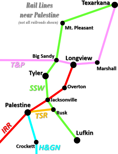 In 1896, the
state of Texas built a five mile railroad near Rusk to haul iron
ore to a prison foundry that had been constructed a decade earlier. It was never chartered but became known as the
Texas State Railroad (TSR). At Rusk, the TSR connected with the St. Louis
Southwestern (SSW) Railroad. As the
foundry
gradually expanded, so did the TSR, building five miles west to Maydelle in 1903.
In 1907, Texas Governor Thomas M. Campbell began to advocate operating the TSR
as a common carrier. Campbell's advocacy no doubt stemmed from his
thorough familiarity with the area, and his particular insight on railroading.
He was a native of Rusk and a long time resident of Palestine where he had been
the Bankruptcy Receiver and the General Manager of the I&GN during its reorganization in the 1890s.
Campbell saw the TSR as a potential profit-making entity owned by the state. The
profits would depend on being able to derive income from exchanging traffic with
the SSW, but doing so would require the TSR to be a common carrier, a
status the
Legislature granted in April, 1907 at Campbell's request.
In 1896, the
state of Texas built a five mile railroad near Rusk to haul iron
ore to a prison foundry that had been constructed a decade earlier. It was never chartered but became known as the
Texas State Railroad (TSR). At Rusk, the TSR connected with the St. Louis
Southwestern (SSW) Railroad. As the
foundry
gradually expanded, so did the TSR, building five miles west to Maydelle in 1903.
In 1907, Texas Governor Thomas M. Campbell began to advocate operating the TSR
as a common carrier. Campbell's advocacy no doubt stemmed from his
thorough familiarity with the area, and his particular insight on railroading.
He was a native of Rusk and a long time resident of Palestine where he had been
the Bankruptcy Receiver and the General Manager of the I&GN during its reorganization in the 1890s.
Campbell saw the TSR as a potential profit-making entity owned by the state. The
profits would depend on being able to derive income from exchanging traffic with
the SSW, but doing so would require the TSR to be a common carrier, a
status the
Legislature granted in April, 1907 at Campbell's request.
When common carrier
railroads exchanged traffic, the revenue for the entire shipment was split using
a negotiated division rate. Thus, the TSR would receive a share of the
total revenue of a shipment, even though the TSR was inevitably a small piece of the
total transport. With common carrier status came two
significant legal obligations for the TSR: they had to offer transportation services to the
public without discrimination, and they had to set public tariffs for their
services and follow them. Thus, the TSR had to begin
charging its owner, the State of Texas, for
freight shipments made by the prison, and they had to charge prison staff for
passenger tickets (but the TSR could haul its own employees for free.)
Access to more than one trunk line would provide leverage to negotiate higher division
rates by favoring the higher-paying connection, hence the TSR was extended west to Palestine in 1909 where it connected
with the I&GN. This gave the TSR two trunk line connections and a 33-mile
track between them.
In 1913, the prison foundry closed, impacting the
TSR's business, and by 1920, the TSR had become unprofitable. The meager
revenue being sent back to State coffers by the TSR had accumulated a balance sheet
deficit of more than $300,000. The Legislature began to consider alternatives
(including abandonment) and formed a special committee
to weigh the choices. The committee recommended funding $150,000 for maintenance
and capital improvements along with creation of a Board of Governors to manage
the TSR; the Legislature
enacted this plan in 1921.
The Board began implementing the rehabilitation
plan, but they soon shifted their strategy toward consummating an agreement to lease the TSR to
the Texas & New Orleans (T&NO) Railroad for 25 years. The T&NO was owned by
Southern Pacific (SP), and SP subsequently merged most of its Texas railroads
into the T&NO. The TSR lease was renewed periodically by SP until 1962. The TSR was
then leased to the Texas South-Eastern (TSE) Railroad between 1962 and 1969. Today,
the TSR
remains owned by the State and is now a historical park and
tourist railroad.
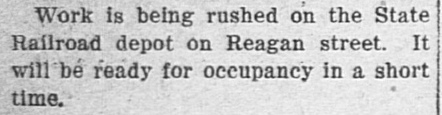
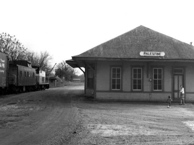
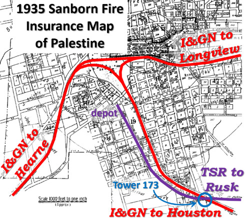 Left:
This 1935 Sanborn Fire Insurance overview map of Palestine has been annotated to
highlight the main rail lines into town. Although the TSR extension into Palestine in 1909 was
mostly for the
benefit of interchanging with the I&GN, the TSR also planned to provide
passenger and freight service to the town. This necessitated having a regular depot, so
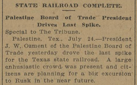
the TSR began building one while laying the final tracks into Palestine. The
TSR tracks were complete in late July (below
left,
Galveston Tribune, July 24, 1909) and
the depot was finished around the first of October (below
right,
Palestine Daily Herald, September 28,
1909.) The placement of the depot reasonably close to the main part of town
necessitated a depot spur of more than a mile beyond the switch for the I&GN
interchange track. The spur had to cross the I&GN main line, thus creating the
crossing where the Tower 173 interlocker became operational on April 15, 1931.
The interlocker was
an 8-function plant most likely consisting of home and distant signals in each
of the four directions. When the T&NO took over the TSR by lease in 1921, the
TSR depot became the T&NO depot.
Left:
This 1935 Sanborn Fire Insurance overview map of Palestine has been annotated to
highlight the main rail lines into town. Although the TSR extension into Palestine in 1909 was
mostly for the
benefit of interchanging with the I&GN, the TSR also planned to provide
passenger and freight service to the town. This necessitated having a regular depot, so
the TSR began building one while laying the final tracks into Palestine. The
TSR tracks were complete in late July (below
left,
Galveston Tribune, July 24, 1909) and
the depot was finished around the first of October (below
right,
Palestine Daily Herald, September 28,
1909.) The placement of the depot reasonably close to the main part of town
necessitated a depot spur of more than a mile beyond the switch for the I&GN
interchange track. The spur had to cross the I&GN main line, thus creating the
crossing where the Tower 173 interlocker became operational on April 15, 1931.
The interlocker was
an 8-function plant most likely consisting of home and distant signals in each
of the four directions. When the T&NO took over the TSR by lease in 1921, the
TSR depot became the T&NO depot.
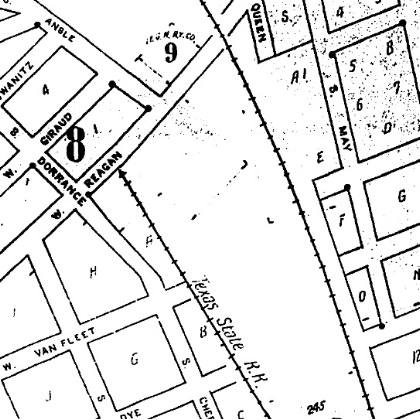
Below Left: The January, 1919 Sanborn Index Map of
Palestine shows the TSR terminating just short of W. Reagan St. and immediately
east of Dorrance St. The other track on the map is the I&GN main line from
Houston proceeding north into the main yard downtown.
Below Center: The detailed 1919 map shows the "Texas
State R.R. Depot" as a rectangular structure roughly three times as long as it
is wide, located directly south of W. Reagan St. with tracks on both sides.
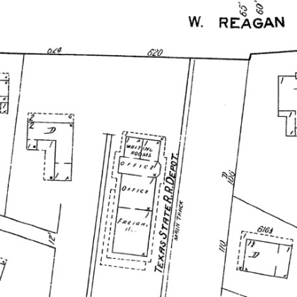
Below Right: This 1946 aerial
image ((c)historicaerails.com) shows the T&NO / TSR depot at Palestine. At the
south end of the depot, the roofline shading implies the presence of a hip roof
while the overall shape of the foundation (4:1 rather than 3:1 as conveyed by
the Sanborn map), along with the obvious shadow near the south end, suggests
there was an outdoor area with no roof. The precise fate of the depot is
undetermined although it has been reported to have burned at some point. It
appears intact in 1976 and 1983 aerial imagery, but 1995 imagery is inconclusive
and it was definitely gone by 2004.
Above Left: Though long
abandoned, the depot spur still showed visible rails on Google Street View across and north of Burkitt St.
in 2013. Above Right: This
photo was taken by Fred M. Springer in 1963 and appears in the on-line
collection of The History
Center of Diboll, Texas. It is identified as the "Palestine Texas State
Railroad Depot, 1963". The T&NO lease of the TSR had terminated in 1962,
replaced by a lease to the Texas South-Eastern (TSE). A TSE switcher with a few
cars sits to the left. The view is to the south, presumably in the parking area
between the north end of the depot and Reagan St.
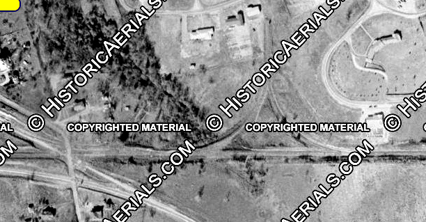
Below Left: There apparently was no turntable at the
depot, hence no way to turn locomotives. To solve this issue, TSR placed a wye
along the main line a thousand feet east of the Tower 173 crossing, visible in
this 1954 aerial image. ((c)historicaerials.com)
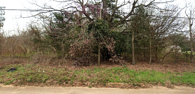
Below Right: Despite its operational presence for 60
years, there is no longer any visual hint that the TSR depot ever sat at this
location on Reagan St. (Google Street View, 2013)
Another Railroad Tower in Palestine
Above: Railroad executive John
W Barriger III took this photo, most likely in the late 1930s or early 1940s, on
a visit to Palestine. Barriger is beside the Railway Express Agency building and
is looking east. The men are standing adjacent to the Magnolia St. grade
crossing. The tower visible past Magnolia St. to the left of the tracks
controlled the east end of the MP yard. There's no indication that it was ever
submitted to RCT for approval, which would likely have resulted in a tower number assignment. Numbering yard interlockers
did not become standard practice until the
mid-1920s, so it may have been built before then.
Below Left: The 1935 Sanborn Map shows the tower as a 2-story
structure (highlighted red) located trackside east of the Magnolia St. grade
crossing. The tower does not appear on the next earlier Sanborn Map of 1919.
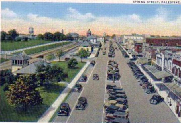
Below Right: This postcard
image of Spring Street in Palestine shows the tower in the foreground at left.