Texas Railroad History - Tower 65
- Algoa
Crossing of the Gulf, Colorado & Santa Fe Railway and the
St. Louis, Brownsville & Mexico Railroad

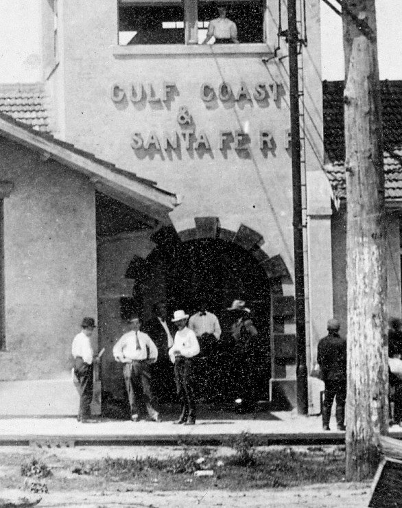
Above Left:
This image from Ken Stavinoha's collection shows the
original Union
Depot at Algoa. The upper
story of this structure presumably hosted the Tower 65 controls and operators. The herald on the side of the
depot says "St. Louis Brownsville & Mexico Railway" (SLB&M) in a circle with "Gulf Coast Line" in
the middle of the circle. The front of the depot has lettering that shows the name "Gulf Coast
& Santa Fe" (above right,
Santa Fe Area Historical Foundation image) while the correct, legal
name of the railroad was "Gulf, Colorado & Santa Fe".
Was this sinply a mistake by the construction company? Was it confusion
with "Gulf Coast Lines" -- the collection of railroads controlled by
B. F. Yoakum of which the SLB&M was a component? The answer is undetermined.
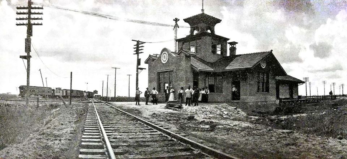
Below: undated photo of the Algoa Union Depot (hat tip Robert
Pierce)
The Gulf, Colorado & Santa Fe (GC&SF) Railway began building its main line
out of Galveston toward Richmond in 1877, passing south of Houston where the
trackside community of Algoa was founded. Algoa never amounted to much of a population center - a couple of hundred people at best,
and it was never incorporated - but it became a railroad junction
in March, 1906 when the St. Louis, Brownsville & Mexico (SLB&M) Railroad
reached Algoa building north from Brownsville. The SLB&M was part of the Gulf Coast
Lines (GCL), a railroad syndicate run by B. F. Yoakum that planned to build
and/or acquire railroads from South Texas north and east through Houston to New
Orleans. Tower 65, a 25-function mechanical interlocker, was authorized for
operation by the Railroad Commission of Texas (RCT) on November 4, 1906 to
control the Algoa crossing. Although it crossed the GC&SF line with the intent of building into
Houston, the SLB&M stopped at Algoa and never
proceeded further. S. G. Reed, in his classic reference tome
A History of the Texas Railroads (The St. Clair
Publishing Co., 1941) explains why:
"It stopped there for two reasons.
The bridging of the Colorado and Brazos Rivers and the construction of the line
through the bottom lands adjacent to these rivers had cost vastly more than
expected. The other was that Yoakum was able to negotiate a satisfactory
contract with the Santa Fe which served Algoa for use of its tracks to Houston,
and with the I&GN for use of its track to Galveston."
In 1897, native Texan railroader
Benjamin Franklin Yoakum became the Chairman of the St. Louis San Francisco
("Frisco") Railway, a major midwest railroad. In 1905, he was named to the
additional position of Chairman of the Executive Committee of the Chicago, Rock
Island & Pacific, another major midwest railroad. For several years during this
period, Yoakum was working semi-independently with the St. Louis Trust Co. to
finance a collection of railroads, the Gulf Coast Lines, to be
assembled by construction and acquisition as necessary. The GCL's objective
was to compete with Southern Pacific (SP) in the Gulf Coast market between
Brownsville and New Orleans, centered on Houston,
an ambitious plan indeed.
As there was no rail line into the Lower Rio
Grande Valley, Yoakum had to build one, hence the SLB&M was chartered. Materials and work
locomotives could be shipped by rail (via San Antonio
and Corpus Christi) to
Robstown, so from there, the SLB&M built 141 miles of track south to Harlingen
and Brownsville in 1904. The following year, the SLB&M built 43 miles north
to Refugio and began a second construction effort from Bay City, completing 31
miles south toward Refugio by the end of the year. In 1906, the remaining 68
miles between Bay City and Refugio was completed as was the 60 miles northeast
from Bay City to Algoa. At Algoa, Yoakum
had negotiated rights to use Santa Fe's line east to Virginia Point where
Yoakum had arranged to use the
International & Great Northern (I&GN) route into Galveston over rails it had
leased from the Galveston, Houston & Henderson (GH&H) Railroad.
(Yoakum did not use the Santa Fe tracks into Galveston, for unknown reasons.)
Less than five miles west of Algoa, Santa Fe's branch line at Alvin would give
him access to Houston, but no agreement with Santa Fe
to use that line had been reached.
Santa Fe may have been driving a hard
bargain, but Yoakum, a former Santa Fe executive, needed their help with
his plan to compete with SP. His position was at odds with his financial backers, the St. Louis Trust Co.,
whose management wanted
him to forget negotiating Houston access with Santa Fe and build eight miles farther north to Dickinson for a
GH&H connection into Houston. Newspaper articles repeatedly described
closed-door meetings and behind-the-scenes intrigue between Yoakum and the financiers,
who were clamoring for the immediate revenue bonanza that would occur when
singe-train service became available
between Brownsville and Houston. Yoakum had a much bigger goal and was adamantly opposed to extending the SLB&M tracks
north from
Algoa. A duplicate route into Houston would damage his working relationship
with Santa Fe, which already had a 25% ownership of the
recently-chartered Houston Belt & Terminal (HB&T); three Yoakum
railroads owned the other 75%. Santa Fe, however, was the only member of the
HB&T consortium that actually served Houston
at the time, hence, much of the HB&T's initial asset base consisted of
Santa Fe rights-of-way, yards and other infrastructure. In particular, Yoakum
needed to use Santa Fe's branch line into Houston from Alvin because it led into
the new yard the HB&T had begun building south of Santa Fe's existing South Yard
(hence, it was called New South Yard.) Yoakum's
entire plan was based on having Santa Fe as a willing partner; he could not risk
damaging that relationship. Furthermore, the SLB&M tracks between Algoa and Bay
City were proving to be problematic through the Brazos River bottom lands, so
Yoakum was in no position to initiate immediate service to Houston anyway, even if Santa Fe had
granted rights via Alvin.

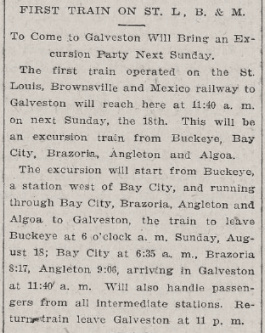 |
Left, Top:
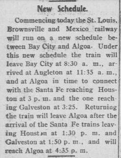
The Galveston Tribune of March 12, 1906
reported the imminent arrival of the first SLB&M train into Galveston from Brownsville. This was, however, a special train, not the
commencement of regular service. The grade, ballast and bridges between
Algoa and Bay City proved insufficiently engineered to withstand the
rainy season in the Brazos River bottom lands east of Bay City. Regular
service did not begin between Brownsville and Algoa for more than a
year.
Also note the reference to Samuel Lazarus as a "personal representative" of B. F. Yoakum. Lazarus
owned the Acme Cement Plaster Co. and had chartered the Acme, Red River
& Northern (ARR&N) in 1902 with plans to build from
Acme to the Red River to meet the Frisco building south through Oklahoma.
Although the ARR&N line was
never built, Lazarus did ship large quantities of cement products over the Frisco,
becoming a major customer and developing a personal friendship with Yoakum. Apparently
Lazarus began to work as Yoakum's
"personal representative" in Texas (Yoakum lived in Missouri
at the time.) In
1909, Lazarus would
re-charter the ARR&N as the Quanah, Acme &
Pacific which soon became a Frisco property.
Left, Bottom: The Galveston Tribune
of August 14, 1907 reported the imminent arrival of the first SLB&M
train into Galveston...wait, haven't we seen this before? This train was
yet another excursion, but it had been so long (~ 17 months) that the
real first train had been forgotten!
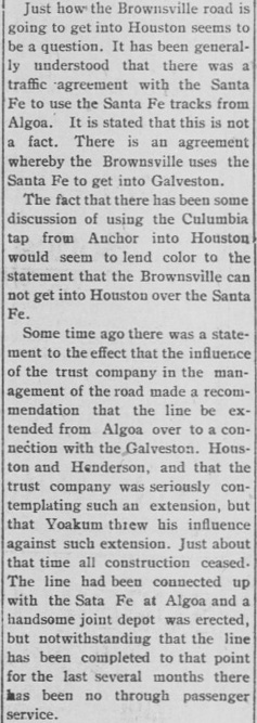
Far Right,
Top: The
Brownsville Daily Herald of September 9, 1907 reported a
revised schedule for SLB&M service between Bay City and Algoa. Since
this indicated that the troubles through the Brazos River bottoms had
been solved, Brownsville citizens couldn't help but wonder why
connections on the Santa Fe were required out of Algoa given that
Yoakum's original plan had been single-train service to Houston.
Right: The
Brownsville
Daily Herald of September 26, 1907 continued to speculate on the
major question of interest among Brownsville citizens: how and when
would the SLB&M reach Houston and begin offering single-train through
passenger servce?
Far Right, Bottom:
The Brownsville Daily Herald of April
13, 1908 announced the commencement of single-train service
between Brownsville and Houston. The final agreement between the GCL and Santa Fe
was dated April 1, 1908. The SLB&M used "westbound" (toward Brownsville)
and "eastbound" (toward Houston) instead of geographical "southbound" and "northbound"
terms because it was part
of the GCL, which had its eastern terminus at New Orleans. Brownsville
was at the other end of the GCL, hence heading toward Brownsville at any
point must
be westbound!
The
GCL was acquired by Missouri Pacific (MP) in 1925. The major GCL lines
between Brownsville and New Orleans remain in service today under Union
Pacific (UP) ownership resulting from UP's acquisition of MP in 1982.
The GC&SF tracks are now a main line of Burlington Northern Santa Fe
(BNSF.)
Was B. F. Yoakum a marketing genius? Check out his
latest book on Amazon! |
 |
 |
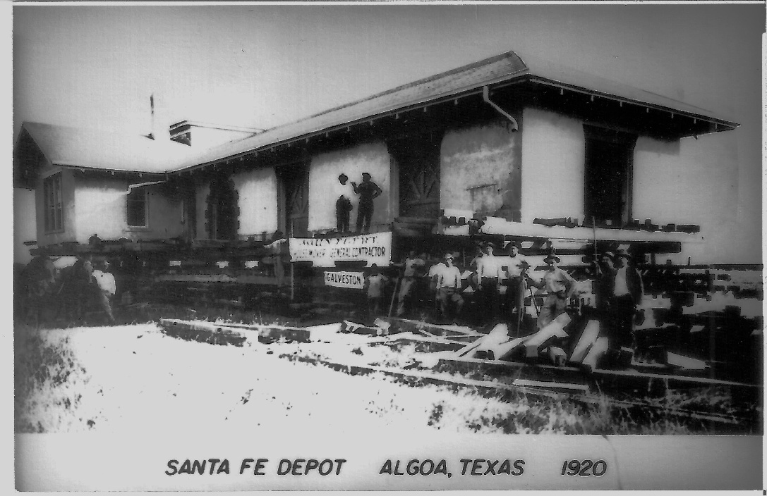
The Santa Fe Area Historical Foundation, Inc. (SFAHF)
operates a museum in the former Santa Fe depot at Hitchcock, ten miles southeast
of Algoa, with the town of Santa Fe located midway between them. According to
the SFAHF, a Santa Fe depot in Algoa was built in 1897, resembling the wooden
depots in Santa Fe and Hitchcock, and the Algoa Union Depot was built in 1904.
SFAHF does not identify a source for the 1904 date which seems much earlier than
expected. The SLB&M did perform construction south
from Algoa to accelerate the line's completion, but it was not separately
reported to RCT (whereas the other separate SLB&M segments
were reported.) Most likely, it occurred during the Bay City - Algoa
construction reported for 1906 and thus would not, by itself, have justified
construction of the Union Depot in an earlier year. [The Brownsville Daily Herald
of March 9, 1906 reported that the meeting point
was "...18 miles north of Bay City and 42 miles south of Algoa."]
The Brownsville Daily Herald of March 9, 1906
reported "At Algoa, which is to be an important junction point, material is
being unloaded for a union station which will be constructed of brick and is to
cost $10,000." The Galveston Tribune
of May 2,
1906 reported "the $10,000 depot...is
nearing completion." This springtime 1906 timeframe is more consistent with the first SLB&M
train into Algoa rather than SFAHF's 1904 date.
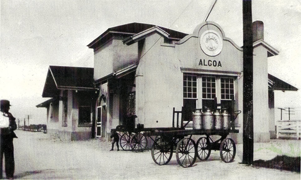
The precise location of the Algoa Union Depot can be
discerned from the photos. The top photo clearly shows the diamond and was
annotated to label the tracks, presumably by someone (the photographer?) who
knew the scene. The Santa Fe tracks were opposite the main entrance to the
depot for passengers, a large arched door. The
shadows in the top photo, particularly of the men, are long and slant away from the Santa Fe tracks
indicating the depot
faced south on the north side of the tracks. The SLB&M tracks are along the east side of the depot, which sat
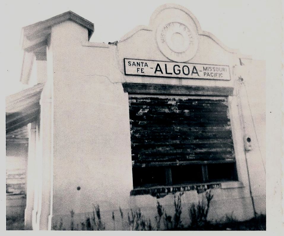
in the northwest quadrant of the diamond. Looking at the third of the three photos above, the semaphore pole is on the
opposite side of the building compared to the top photo, hence the view is
facing south along the SLB&M tracks on the east side of the depot. The train is
turning south toward the Rio Grande Valley having come off of the Santa Fe
tracks from the east (presumably from Galveston.) The train is on the connector track southeast of the diamond and
the people gathered along the east side of the depot are most likely waiting for the train to backup next to the depot to
discharge passengers and/or accept new passengers for the journey
south. This photo also shows three semaphore poles visible beyond the utility
poles to the right of the depot. This is approximately where the southwest
connector track would join
the Santa Fe main line.
Documents in the RCT archives held at DeGolyer
Library, Southern Methodist University help explain the basis for Tower 65. On
June 6, 1911, apparently in response to a request, RCT wrote a letter to Santa
Fe authorizing removal of the grade crossing and
temporary abandonment of the interlocking plant. A subsequent letter from
Santa Fe to RCT dated September 23, 1914 recalled RCT's 1911 authorization and
reminded them that the Tower 65 interlocker had been "originally installed
at the time the Brownsville road was contemplating the construction of its line
into Houston. The track was only built a short distance beyond our line, and has
since been taken up and removed. They now make use of our line between Algoa and
Houston." Santa Fe's letter proceeds to request authority to permanently
abandon the Tower 65 interlocker, presumably to scrap the plant and associated
signals and derails that had been decommissioned but retained when the temporary
abandonment had been authorized. RCT granted permission for permanent
abandonment in a letter back to Santa Fe on September 28, 1914.
Regardless of whether Yoakum seriously considered
building his own line into Houston, the crossing diamond at Algoa was necessary,
at least initially, because the union depot was on the north side of the Santa
Fe tracks and SLB&M trains needed to reach the east side of the depot.
Topographic maps show the short spur to the north past the depot, and its
possible that a primitive SLB&M maintenance yard and/or turntable was located at
the end of it (which makes sense, i.e. the SLB&M would need basic supply and
maintenance capabilities away from its home base in Kingsville, and Algoa was
the northern terminus of SLB&M tracks.) Accessing
Galveston required the SLB&M to use the Santa Fe main eastward whereas reaching
Houston required taking the Santa Fe main west to Alvin. SLB&M passenger trains
had to back out of the depot across the Santa Fe main line and go far enough
south to access the connecting tracks in the southeast (Galveston) or southwest
(Alvin) quadrants.
The Official Railway Guide (ORG) of 1908 lists
regularly scheduled SLB&M service between Brownsville and Houston, but does not
show any SLB&M service to Galveston. In his grand scheme, Yoakum assigned
Galveston operations to the Trinity & Brazos Valley (T&BV) Railway. There was a
reason for this. The T&BV was not a GCL railroad; it was half-owned by the
Colorado & Southern (C&S), a railroad where Yoakum served as a Director and with
whom he had orchestrated the takeover and redirection of the T&BV to become a
bridge line between Dallas/Fort Worth and Houston. (Yoakum's Rock Island owned
the other half.) The C&S had railroads from Denver to
Fort Worth, and with the T&BV serving Galveston and Ft. Worth, the C&S could
claim to have a direct Denver - Galveston route, something no other railroad had
at the time. The 1908 ORG shows a C&S map with a direct line from Denver to Fort
Worth to Galveston (...and since the T&BV's tracks north from Houston toward Ft.
Worth only went as far as Cleburne, another indication of Yoakum's need to keep
Santa Fe happy was that the T&BV segment from Cleburne
to Ft. Worth used rights on Santa Fe's line.) RCT's 1913 Annual Report lists the T&BV as having
46 miles of trackage rights on the Santa Fe between Houston and Galveston. These rights dated back to Yoakum's 1908 agreement with Santa
Fe; the aforementioned 1908 ORG map shows Algoa as the only T&BV stop between
Houston and Galveston (because it was the connecting point for C&S/T&BV
passengers to reach Brownsville.) A T&BV ad in the Galveston
Tribune dated April 25, 1914 proclaims THROUGH SLEEPERS via T&BV "The
Short Line" --TO-- DALLAS, FORT WORTH, DENVER For Reservations Phone 2220.
The T&BV's overnight train from Galveston to Ft. Worth was listed in the same
newspaper's Schedule of Arrival and Departure of Trains (departing 9:30
pm, arriving 9:15 am.) It was the only T&BV train listed.
In contrast to the T&BV,
a cursory examination of schedules and advertisements in the
Galveston Tribune during this timeframe fails
to find any mention of SLB&M trains. There is no evidence that regularly scheduled SLB&M trains
operated between Brownsville and Galveston, although excursions and other
special trains undoubtedly ran on occasion. Without regular service to
Galveston, it was readily apparent that there
was no reason for SLB&M trains to use the east side of the Algoa depot. Trains
from Brownsville to Houston could take the southwest connector, move on to the Santa Fe
main line, and then backup in front of the depot. Trains heading to the Valley would pull
up to the depot, and then depart by backing up far enough to take the southwest
quadrant connector toward Brownsville. Although permanent abandonment was not
authorized until 1914, the temporary abandonment granted in 1911 showed up in a table dated October 31, 1913
published by RCT where Tower 65 was listed as "abandoned and crossing removed".
The bottom line: it simply
wasn't needed if the SLB&M was not running scheduled service to Galveston.
And although Santa Fe's letter to RCT in 1914 stated that the short track north
of the original grade crossing had been removed, the track reappears in a 1929
USGS Topographic Map, accessible by a connection off the Santa Fe main
line. It's purpose remains undetermined, and it does not appear on a 1956
Topographic map.
 |
In 1914, the Frisco entered receivership. As a
result, the GCL had to be reorganized so that a single entity would own
all of the component railroads (since the Frisco no longer did.) A new
parent company, the New Orleans, Texas & Mexico (NOT&M) Railway was incorporated
in 1916, with the SLB&M as one of its railroads. Perhaps as a result of
this significant change in corporate control, the SLB&M and the GC&SF
established a new contract (left)
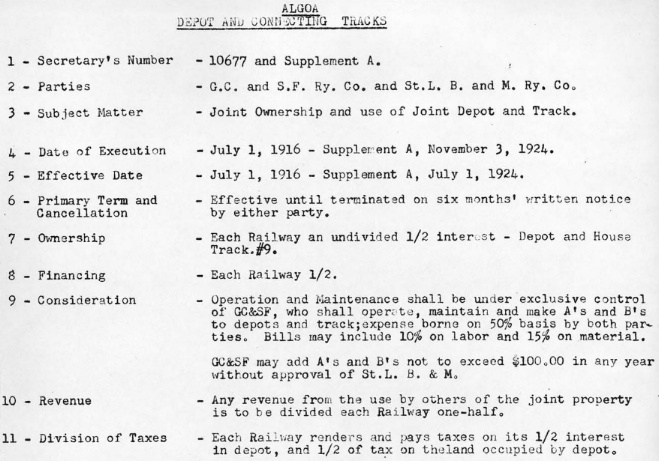
on July 1, 1916 defining their joint use of the depot and connecting tracks at Algoa.
The contract covered basic financial issues -- everything was split
50/50 -- and it assigned Santa Fe the responsibility for all A-level and
B-level maintenance activities, with the proviso that Santa Fe could add
new items up to an annual sum of $100 without getting SLB&M
approval. All maintenance expenses were split 50/50 but Santa Fe was
allowed to add 10% overhead on labor and 15% on material for the
internal cost of administration and purchasing. The contract was
amended on November 3, 1924 with a retroactive effective date of July 1,
1924, but the elements of this amendment are undetermined. (Santa Fe Railway Historical and Modeling Society)
The
NOT&M operated independently until 1925. To gain entry into the Texas
market, MP tried to buy the I&GN in 1924 but the Interstate Commerce
Commission (ICC) nixed the sale for competitive reasons. In a bit of
corporate subterfuge, MP convinced the NOT&M to buy the I&GN, and that
sale was approved in June, 1924. MP then bought the NOT&M on January 1,
1925, getting the target I&GN along with all of the GCL railroads. The
sale was approved by the ICC, and that's how the SLB&M line became an MP
(and now UP) property. |
 |
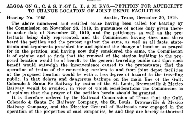
During the
1915 hurricane that struck the vicinity of Galveston, the Algoa depot
suffered major damage including the tower structure being toppled.
Presumably, enough repairs to the depot were made for operations to
continue, but Santa Fe and the SLB&M agreed to seek RCT permission to
build a new joint depot at a location far enough west that SLB&M trains
would no longer need to backup to reach or depart the depot. RCT accepted the safety arguments in
favor of the new location and issued this order (left)
on December 20, 1919 granting the railroads authorization to relocate
their depot to the west (but the platted locations of Sixth and
Seventh Street are undetermined.) Below:
This SFAHF photo shows the destruction of the 1915 storm. The tower was
blown off and there was heavy damage throughout the building.
 |
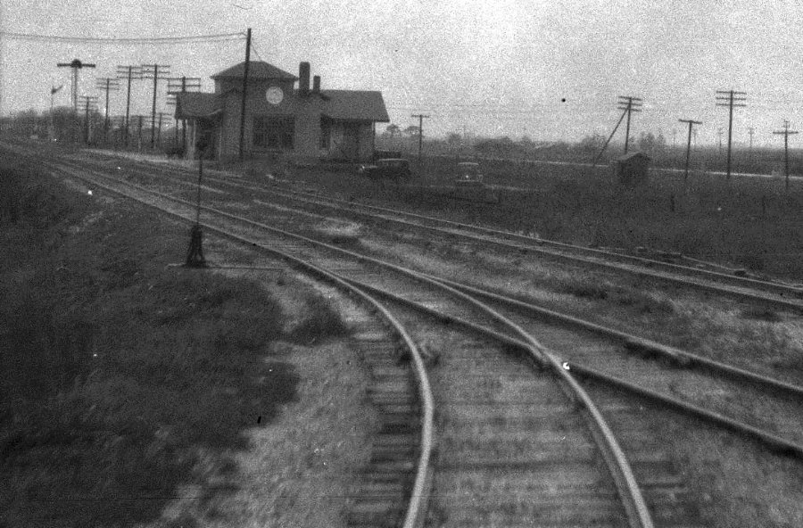
Above:
John W. Barriger III took this photo from the rear platform of his private rail car
sometime in the mid-1930s, roughly 20 years after the 1915 storm. Barriger's
train is entering the southwest connector to head south toward Brownsville on
the SLB&M and his view is in the opposite direction, northwest toward the Union Depot with the Santa Fe
main line passing in front. As a result of the 1915 storm, the depot had been
rebuilt west of where this connector departs the Santa Fe main line. The new
Union Depot appears to have followed the original design but the tower structure
was omitted since there was no interlocker to manage. Curiously, there is no
apparent crossover track for reaching the depot from the connector. GCL
timetables (under MP ownership) continued to show stops at Algoa into the 1950s. (courtesy John W Barriger
III National Railroad Library) Below:
This photo from SFAHF shows the Algoa Union Depot taken after it was rebuilt at
the new location. The herald on the east side of the depot says "Gulf Coast
Lines" (plural as it should be, unlike on the original depot) but without the
SLB&M name around it.
Above: The Santa Fe
freight depot appears to be undergoing relocation, presumably a result of RCT's
order authorizing a new location for the Union Depot. (Jim Williams collection)
Above: The circular herald on the side of the
Union Depot in this post-1925 photo faintly shows "Missouri Pacific Lines"
along with a station sign that lists both of the railroads. The depot survived
until the late 1950s or early 1960s. (SFAHF photo)
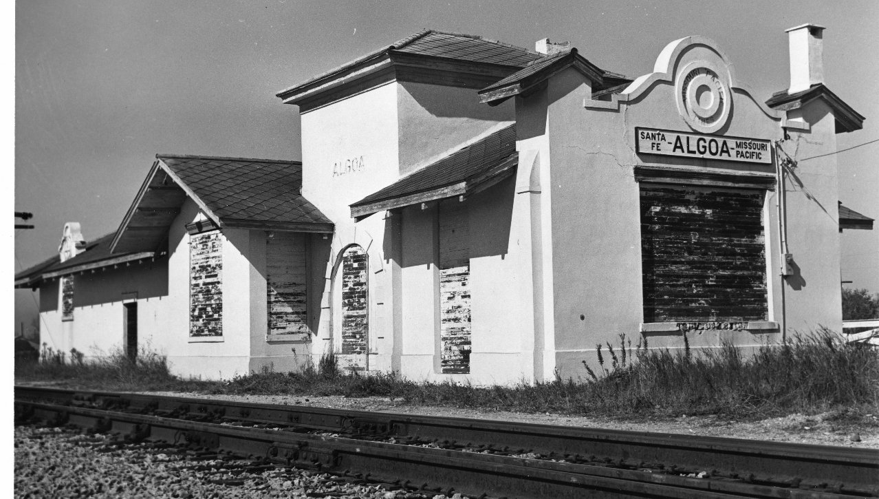
Below: This stock file photo from the
Houston Chronicle
shows the abandoned depot. A handwritten note on the reverse side says that the
depot was built "less than a dozen years ago". Unfortunately, the note's
handwriting does not match other handwriting on the back that lists the date as
"12-1962" along with a "Chronicle Files" stamp. The "12-1962" reference was
likely the date the photo was added to the Chronicle's files, not necessarily
when the photo was taken or if the "dozen years ago" notation refers to 12 years
before 1962. (Jim Williams collection)

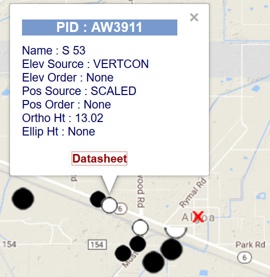
Above Left: This 1956 topo map shows a rectangular
structure (across from the BM 43 label) at the location that corresponds to the
approximate position of the rebuilt Union Depot as it appears in Barriger's
photo, west of the junction of the southwest connector track. The map also shows
a crossover leading to the depot. Note the southwest connector is double track,
as it remains today. Above Right:
This information from the National Oceanic
and Atmospheric Administration
shows the location of a USGS benchmark, AW3911, substantially west of the original
Tower 65 crossing.
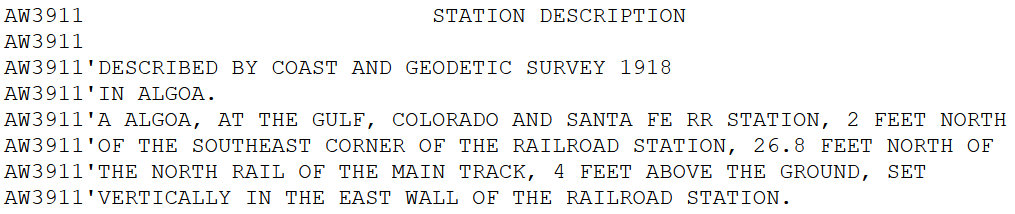
Below: AW3911 was located in
the east wall of the Santa Fe station in Algoa. The 1918 survey date, prior to
the depot relocation authorized by RCT, likely indicates the year the government
initiated the survey, but does not necessarily specify the year when the survey
reached Algoa. Although it describes the location as the Santa Fe station, it
was presumably the massive (and immoveable!) Union Depot at the new location.
 |
Left:
The 1929 USGS map shows a stub track from the south that apparently was
the line to the north until the crossing was removed. It also shows that
as of 1929 (long after the Union Depot was rebuilt to the west), there
was a spur track to the north on the original alignment, possibly
associated with SLB&M maintenance since their track ownership terminated
at Algoa. Note that the map shows streets across from "BM 43" which look
like depot access roadways. The
depot is a small black square.
David Currey comments:
"I used to be a brakeman on the Missouri Pacific's Kingsville
Division. To me, the way the Missouri Pacific got onto the Santa
Fe at Algoa sure looked like maybe there used to be an interlocking
there. But my official guide from 1930 doesn't show such a thing.
Then in my Wells Fargo bank, there was a map of their routes around
the turn of the century, and there was a line drawn from Algoa
to Houston separate from the Santa Fe. All the other lines on
the map appeared to be accurate representations of rail routes,
so why should the StLB&M route be drawn any less accurate? I went to Algoa and poked around, including asking some of
the locals, and none could help me much, except one said there
used to be a turntable there, which I find hard to believe. The
only evidence I could find was a road which on the map lined up
with where the track would have been had it continued on past
Algoa. This road also made sort of a jog as you might expect if
it had crossed over the tracks to continue on the other side.
Also, two private driveways were directly opposite each other
in the jog, which seemed pretty odd and too coincidental." |
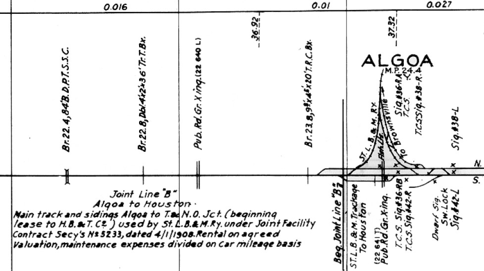
Above: This image of a portion of a Santa Fe track chart of the main line through
Algoa shows the SLB&M junction. South is 'up' and Galveston is to the
left. The 'Joint Line B' agreement (indicated by the shaded area on the map)
covered main tracks and sidings from "Algoa to T&NO Jct. (beginning lease to
HB&T Co.)". SLB&M's route into Houston was from Algoa to Alvin on the original
GC&SF main line and then from Alvin to T&NO Jct. (Tower
81) on a
line that Santa Fe built in 1883 to reach Houston. North of Tower 81, the Santa
Fe tracks were leased to HB&T leading into
New South Yard. (Santa Fe Railway Historical and
Modeling Society)
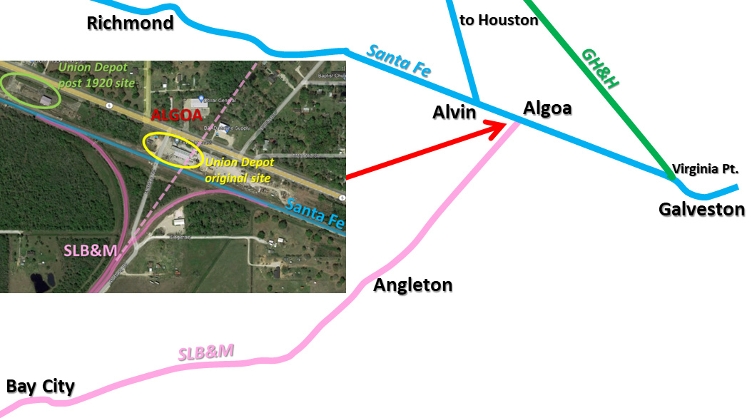
Above: area map with inset annotated Google Earth satellite image of Algoa;
the Tower 65 interlocker was only at the original Union Depot site