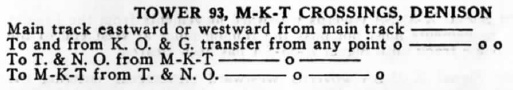
Texas Railroad History - Tower 93 and Red-Tex Tower - Denison
and the Red River Bridge
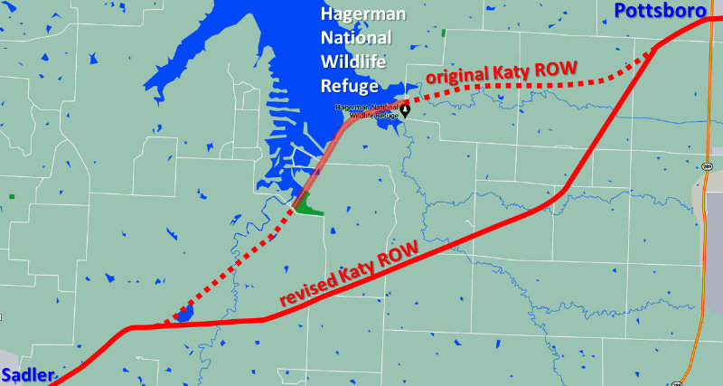
Junctions of the Missouri - Kansas - Texas Railroad
with
the Houston & Texas Central Railway and the St. Louis San Francisco Railway
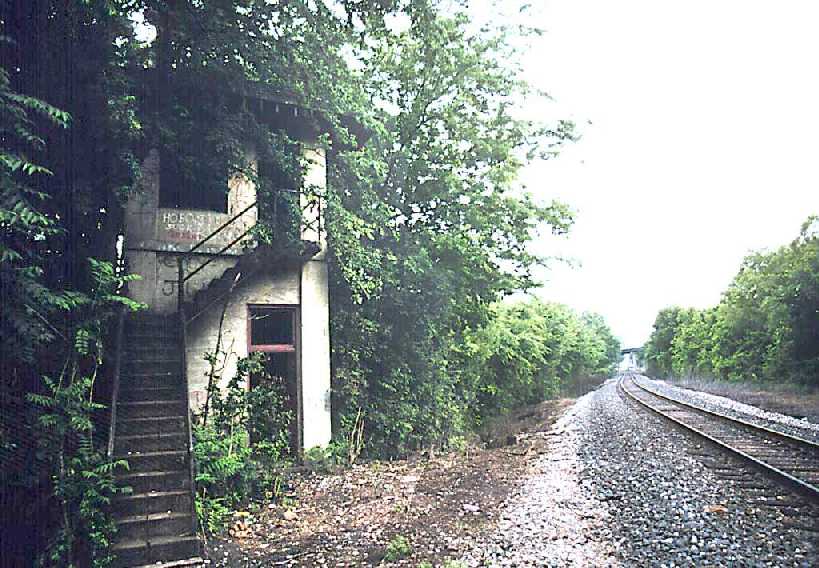
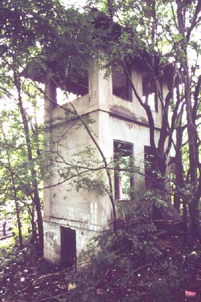
Above: These two photos of
Tower 93 were taken in April, 1995 by Mike O'Brien. The 2-story concrete
structure was built by the Missouri - Kansas - Texas (MKT, "Katy") Railroad in
1913, employing essentially the same design plan they had followed for Tower 53
in Ft. Worth. The track view is to the southwest along the Southern Pacific (SP)
rail line to Dallas. From this perspective, the former Katy line to Bells
(abandoned in 1988) crossed SP's tracks behind the camera and passed to the left
of the tower, which was commonly known as Lamar Tower.
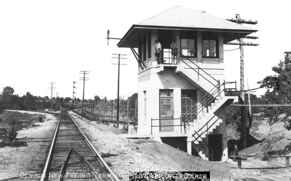
Below Left:
Red-Tex Tower (later called Staley) was a Katy-constructed tower in Oklahoma
immediately north of the rail bridge over the Red River. Among other duties, it
managed the St. Louis San Francisco (SLSF, "Frisco") Railroad's access to the
bridge for their line to Madill, Oklahoma, and the switch for Frisco's track into
Denison on the Texas side. Although Red-Tex controlled switches and signals in
Texas, no evidence has been found to suggest that it was ever under the
jurisdiction of the Railroad Commission of Texas. (photo courtesy of Mike
O'Brien from Missouri - Kansas - Texas Lines, Larger
Construction Projects, 1920-1923 reprinted by the Katy Railroad Historical
Society.)
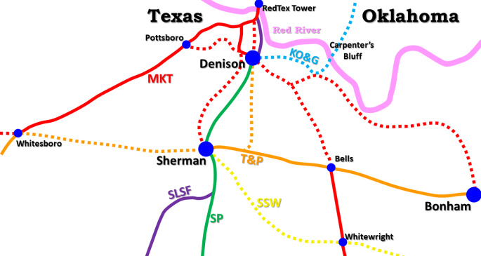
Below Right: This "big
picture" map shows the approximate alignment of historical rail lines in the
vicinity of Denison and Sherman with the traditional operating
railroads identified by color. None of these traditional railroads still exist;
they've all been amalgamated into larger corporations. The importance of this area in Texas railroad history is evidenced by the complex
arrangement of tracks and the presence of almost every major rail system that
ever served Texas. Though not apparent from the map, Missouri Pacific (MP), a major
railroad in Texas, was also present. By 1881, it had leased both the Texas & Pacific
(T&P) and the Katy. It lost control in the late 1880s, but by 1930, MP owned
75% of T&P's stock. T&P and MP operated cooperatively over the decades until T&P
was formally merged into MP in 1976. By then, T&P owned the Kansas, Oklahoma &
Gulf (KO&G) Railway and its bridge over the Red River east of Denison
at Carpenter's Bluff. Union Pacific (UP) bought the Katy
in 1988 and merged it into MP, which it had acquired in 1982. The only major
railroads in Texas that did not own tracks into Sherman or Denison were Santa
Fe, Kansas City
Southern and Rock Island. However, Santa Fe did serve Sherman briefly using
rights on the St. Louis Southwestern (SSW) from Wolfe City, and Rock Island was
mutually controlled with the Frisco by native Texan B. F. Yoakum when Frisco's
rails to Sherman and Denison were built.
Denison is an important town in
the history of Texas. It is
the birthplace of US President Dwight Eisenhower and it was Texas' first rail gateway to the north. Connections from Texas to
St. Louis, Kansas City and Chicago passed through Denison, opening Texas' ports
on the Gulf of Mexico to the manufacturing and processing centers of the midwest.
The town was named for George Denison, Vice President of the Missouri - Kansas -
Texas (MKT, "Katy") Railroad, but it was founded by William B. "Ben" Munson, a real estate promoter trying to lure the railroad toward his land a few miles south of the Red
River. As the Katy was building south through Indian Territory (Oklahoma) in
1871-72, Munson acquired property north of Sherman, laid out a town, and began lobbying Katy officials
to cross the river nearby, which they did in
December, 1872. At the same time, the Houston & Texas Central (H&TC) Railway was
building north toward the Red River, the culmination of a lengthy
effort to build from Houston that had begun in
1856. Construction records of the
Railroad Commission of Texas (RCT) list 1873 as the year the H&TC reached
Denison and there are other sources that specify it as March, 1873. In
his classic reference, A History of the Texas
Railroads (1941, St. Clair Publishing), S. G. Reed, the dean of Texas
railroad historians, asserts it was March, 1872 when the H&TC arrived, but he is
likely referring to grade construction crews and other advance parties that were
working to establish Red River City as a base of operations for the H&TC at the
river.
"The Katy had trouble in getting
its track from the Red River to Denison, a distance of 6 miles. The H&TC had
reached Denison in March, 1872, and had already graded its line to the Red River
and had laid out a town on its south bank called Red River City. The Katy forces
undertook to grade alongside the H&TC grade and on its right-of-way from the Red
River to Denison, but were stopped by an injunction. An agreement was effected
under which the H&TC abandoned Red River City, took up its tracks from Denison
to Red River City, and entered into a contract for a joint station at Denison.
... At the same time, a close working agreement between the two systems was
effected on traffic between Texas and Northern points."
Red River City had a tiny population by early 1872, and
it's clear that the H&TC was planning to develop it into some kind of operations
base much closer to the river than Sherman. Sherman had offered financial
incentives to the H&TC and the H&TC tracks had arrived there in 1872, but
Sherman refused to offer a bonus to the Katy despite a vigorous campaign in
favor of it by Ben Munson. This setback was the impetus for Munson to acquire
significant land holdings on high ground a few miles south of the river and
begin his lobbying effort with the Katy. Reed's comment that the H&TC "took
up its tracks from Denison to Red River City" was a few years later in the
story as events played out between the Katy and the H&TC with respect to
rights-of-way and the fate of Red River City. Whatever the precise timing of their respective
arrivals at Denison, cooperation between the two railroads took a
few years to develop and the traffic agreement ultimately worked well; Reed described it
as "practically a through line". By 1876, the Katy and the H&TC
were jointly operating Pullman cars between Houston and both St. Louis and
Hannibal, Missouri.
Cooperation continued even as the H&TC became owned by the vast Southern Pacific
(SP) Railroad in 1883 and the Katy built farther into Texas, reaching Houston in
1893.
The arrival of the railroads and the anticipation of economic
growth caused Denison's population to increase rapidly. Ben Munson and his
business partner, Robert Stevens, had laid out the town in 1872. Collaborating
with Katy executives, Stevens formed the Denison Town Co. and began selling lots
in town as the Katy's authorized agent in September, 1872. By the summer of 1873
(and some sources claim January), there were 3,000 people living in Denison. Munson had a background in surveying, and
with his land holdings in the area, he formed real estate and
insurance businesses that brought substantial wealth. Munson's brother, Thomas
Munson, was a scientist from the University of Kentucky who specialized in studying grapes.
Ben convinced Thomas to relocate to Denison to join
the real estate business and Thomas continued his
viticulture studies there by focusing on the ample assortment of wild grapes he
encountered on
field trips around Texas. His research proved to be so valuable that he is credited with
saving the entire
French wine industry! The French government awarded him the
Chevalier du
Merite Agricole in 1888, only
the second American
to receive that award (after Thomas Edison), and inducted him into the
French
Legion of Honor. Today, Denison's official "sister city" is Cognac, France.
With the local economy growing, two groups of investors
began planning rail lines out of Denison. The first was the the Denison &
Southeastern (D&S) Railway chartered in 1877 to build a line from Denison to
Greenville. The second was the Denison & Pacific
(D&P) chartered in 1878 to build 42 miles west to Gainesville, which was accomplished
in 1879. In late 1879 or early 1880, the D&S finally began construction and
built 20 miles from Denison to Whitewright. There,
the D&S changed its name to
the Missouri, Kansas & Texas Extension Railway on March 23rd, a couple of
weeks after it had acquired the D&P. It then built
the final 32 miles to Greenville during the remainder of 1880. The name change
was part of a plan to convince the Katy to acquire the combined railroads,
which they did in November, 1881. This gave the Katy two lines out of Denison: southeast to Greenville and west to Gainesville.
Greenville became an important junction for the Katy as they eventually had
tracks from there to Mineola,
Jefferson, Dallas and McKinney. The Dallas line was
purchased from the Dallas &
Greenville Railway which built 52 miles between its namesake cities in 1886 with
implicit backing from the Katy.
In 1880, the
Texas & Pacific (T&P) Railway was controlled by rail baron Jay
Gould who also controlled the Katy. The T&P had a main line from
Texarkana
to Sherman and planned to continue it southwest to Ft. Worth. Gould directed
that T&P's route to Ft. Worth proceed west to Whitesboro before
turning south to Ft. Worth. Whitesboro was on the D&P line between Denison and
Gainesville, a line that Gould knew the Katy would soon be acquiring. Routing
via Whitesboro would allow Gould to establish a T&P/Katy connection there, even
though the two lines did not need to cross as they passed through town. This
would effectively create a direct route between Denison and Ft. Worth for the
Katy. The T&P sold the Katy rights on the new line from Whitesboro to Ft. Worth and
the two railroads operated it as a joint line under terms of a 99-year agreement. Under T&P
ownership, Gould then bought the bankrupt Dallas & Wichita Railway and extended
it 17 miles north to Denton on the shared line to Ft. Worth. The T&P sold this Dallas-Denton line to the Katy in December, 1881,
giving the Katy a route between Denison and Dallas via Whitesboro and Denton.
This was actually the first Katy line to Dallas since the Katy's route via
Greenville was still five years away.
 |
Left: This
Sanborn Fire Insurance Co. overview map of Denison from
January, 1930 has been annotated to highlight rail lines. The yellow circle is Union Station
from which Tower 93 was visible, about 600 yards south.
The
green circle is the location of the "Katy Tie Plant" which was the W.
J. Smith Wood Preserving Co. near the original Ray Yard ("Old Ray").
The current Ray Yard ("New Ray") was built in the 1920s and is
a major UP freight and maintenance facility.
The Katy freight
bypass (pink track) was built in the fall of 1911 to expedite movements
between Old Ray and the Greenville line, which required crossing the SP
at grade. The Katy line to Greenville also crossed the SP tracks nearby,
and an interlocker was installed as Tower 93
in 1913.
As of 1930, three lines converged north onto
the Katy's
Red River bridge and three lines went south to Sherman. Two
Katy lines converged to a single track at Pottsboro and continued
west. Eastward, the KO&G line crossed the river at Carpenter's Bluff
while the nearby Katy line went to Greenville. The overview map above
shows that today, Denison has only two lines going north, no lines going
east, and one line each in the south and west directions. |
In the late 1880s, Gould's control over the Katy lapsed.
It did not help that a new Texas Attorney General had been elected on a campaign
promise to wage legal attacks against Texas railroads for poor service and non-competitive activities.
Texas Attorney General (and future Texas Governor)
James
S. Hogg proceeded to sue the Katy in 1887 for non-compliance with Texas'
railroad ownership and service laws. In 1890, the Texas Supreme Court affirmed a
lower court's order against the Katy. In response, the Katy's Texas holdings
were consolidated in 1891 under a new state law that chartered the "Missouri -
Kansas - Texas of Texas Railroad", a wholly-owned subsidiary of the parent Katy
Railroad. Its headquarters were at Denison, an in-state location required so
that the company would not be considered a "foreign" corporation.
In 1890, plans were made to build yet another line from Denison to Dallas,
one that would be
routed due south via Sherman. The Sherman, Denison & Dallas (SD&D) Railway was
chartered for this purpose even though by this time, the Katy already had two
routes to Dallas (via Greenville and via Whitesboro/Denton), and any such line
via Sherman would merely duplicate SP's existing line. The proposal to build all the way to Dallas may have
been nothing more than publicity, but the Katy did need its own line to
Sherman. Sherman was a population center, larger than Denison, and was a
source of passenger traffic, particularly northbound. The SD&D completed
ten miles of track from Denison to Sherman in 1890, and the line was formally acquired by the Katy in
1891.
Though no longer under common control, the T&P and the Katy
continued sharing the expense of maintaining the Whitesboro-Ft. Worth line, an
arrangement that lasted for more than a century until both were consolidated under common
UP ownership. In 1896, the T&P proceeded to build its own line from Sherman to Denison under the charter of the Denison & Pacific Suburban (D&PS)
Railroad. The tracks went eight miles north to Denison departing from the T&P
main line three miles east of Sherman. Its impetus was
essentially the reverse of the SD&D, i.e. Denison was a source of traffic for the T&P
via Sherman to points east (Texarkana) and west (El Paso.)
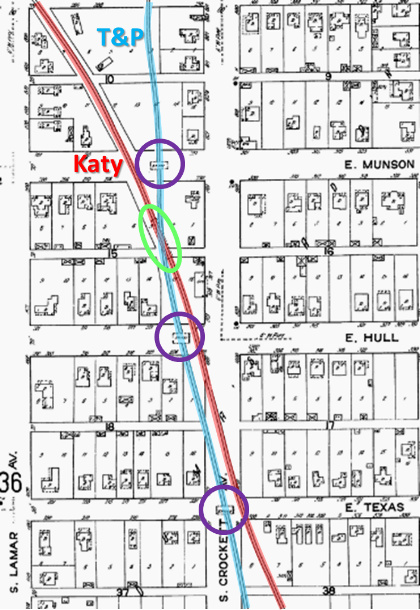 |
Left: This annotated image from the 1914 Sanborn
Fire Insurance map of Denison shows that the T&P (through its D&PS
subsidiary) entered Denison from the south and generally ran north
along the east side of town. Nearing downtown the right-of-way (ROW) was below ground,
either on purpose or perhaps due to local geography features. The result was that
the T&P went under three street bridges (purple circles) and through one
short rail "tunnel" (green oval) where it passed beneath the
Katy line to Greenville.
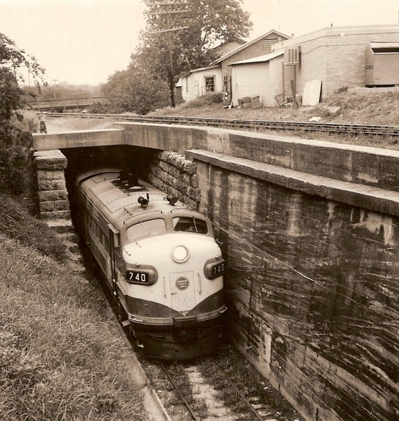
Right:
This photo of a Missouri Pacific diesel locomotive shows it coming south
through the T&P tunnel beneath the Katy tracks. The Munson St.
bridge over the T&P tracks can be seen in the distance. Jimmy Barlow reports
that a caption associated with the original photo says... "The
photo was taken on May 7, 1965. It records the last run out of Denison
before the line was abandoned. Local citizens referred to this tunnel as
the 'T&P Cut.' The tunnel is now completely buried, only the concrete
cap is visible."
(Denison Herald photo) |
 |
In 1886, the Denison & Washita Valley (D&WV) Railroad
was chartered to build a rail line to begin on the south side of the Red River
bridge and run five miles to "Ray". Ray was actually a small community located
near the river, about where the dam for Lake Texoma would eventually be built
and certainly much less than five miles from the bridge (and a line
was built to Ray when the dam was constructed,
but
that was several decades after 1886.) Rather than the community of Ray, the D&WV
tracks ran southwest for five miles to the site of Ray Yard on the west side of
Denison.
The line began at Warner Junction, a name of undetermined origin where the D&WV
switch was installed along the Katy tracks just over a mile south of the
bridge. Ben Munson, Denison's
founder, was the President of the D&WV, which was owned by the Katy.
In 2005, Joe Pike explained the evolution of Ray Yard...
When Katy outgrew its
facilities in downtown Denison, it built a new freight classification yard on
the west edge of town and called it Ray. (Alongside was the Katy-controlled W.J.
Smith Wood Preserving Company, which was Katy's source of crossties, poles,
bridge timbers, etc., until the Katy was merged into Union Pacific and the "tie
plant" as it was known locally died.) In time, the Katy outgrew Ray, and in the
early 1920s, they built a huge new multiple-yard, rider-hump freight terminal
northwest of Denison complete with a new, brick roundhouse with locomotive shop.
They named it Ray and then abandoned Old Ray. The main line that
went by Old Ray remained in place and became the passenger main
to Fort Worth and Wichita Falls until it was abandoned by William
N. Deramus III, President of the MKT from 1957 to 1962. Just east of Old Ray, Katy installed a turnout in the main,
named it Dallas Junction, and built a new, slightly serpentine
freight route to the east end of Ray Yard. This new route was used
by freights going through downtown Denison to/from the Dallas
Subdivision line and by transfer runs between New Ray and the
Katy car shops and the interchanges with SP, the Frisco,
the Kansas, Oklahoma & Gulf, the Texas & Pacific, and
the Texas Electric Ry., downtown. A new freight line was built
from the west end of new Ray to a connection with the old main
line named Pottsboro Junction. This was used by freights going
to/from Whitesboro and thence Wichita Falls or Fort Worth. Rather than having all freight traffic to/from the north wind
its way through Denison over numerous grade crossings, Katy built
a new freight line called the Warner Cut-off from the south end
of the Red River bridge to the east end of New Ray. The new tower
at Red-Tex (Staley) was part of the overall new Ray project.
The line Joe described as "...a new, slightly
serpentine freight route to the east end of Ray Yard." was actually the
1886 D&WV route that had led to Old Ray from Warner Junction. Joe's
understanding was that a new "Warner Cutoff" had been built, but that was just
the northern part of the D&WV albeit with new, heavier track and perhaps a few
minor grade adjustments over the years. It is interesting to note that where the
Warner Cutoff connects to the east end of "New Ray", Sanborn Fire Insurance maps
of Denison show that the Katy owned a ROW that proceeded northeast into Fairview
Cemetery aligned with what is now the east section of Texoma Drive. The maps do
not extend far enough east to show the extent of the ROW, and no evidence has
been found that the ROW was ever used. This ROW angling into Fairview Cemetery
can be seen on the Sanborn overview map (farther above) where the blue dashed
line beneath "to Red River bridge" intersects the red highlight to the left.
Substantial track
changes occurred in west Denison around 1957.
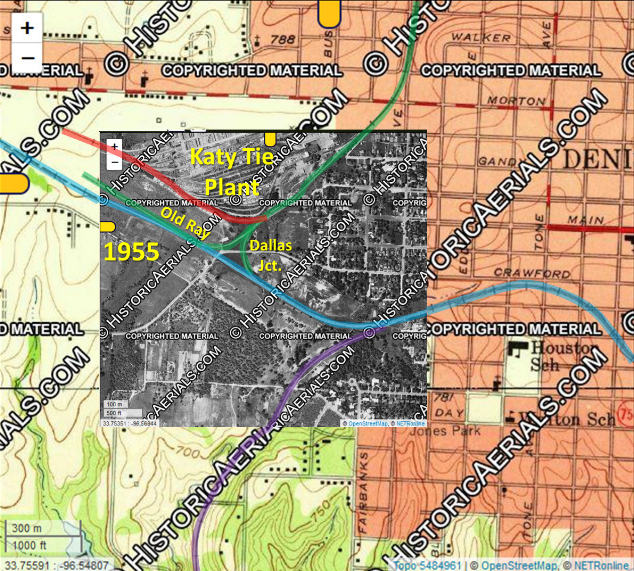
Above Left: This graphic shows a 1955 aerial image ((c)historicaerials.com)
superimposed on a 1959 USGS topographic map in the vicinity of the W J Smith
Wood Preserving Co. ("Katy Tie Plant".) The green track (which was
part of the original D&WV construction) connects the remnants of
Old Ray with the east end of Ray Yard off the top of the map. It also served the
tie plant (red track) and facilitated movements between Ray Yard and
downtown via Katy's original D&P line (blue track) from downtown
Denison toward Pottsboro. Where the Katy's line to Sherman (purple track)
joins the D&P (blue track), the ROW carried both tracks into downtown. Crossover
switches allowed trains to change tracks as required, for example, for movements between Ray Yard and Katy's line to Greenville (off
map at right). The freight bypass (off map at right) came off the
south track (the Sherman track) but the switch at Dallas Jct. for Ray Yard was
off the north track (the D&P.) Above Right:
Four years later, the 1959 topographic map shows a major reconfiguration of the
tracks near the tie plant. The track into the tie plant (red) and the track to
Ray Yard from the remnant at Old Ray (green) were unchanged, but changes occurred everywhere else. West of
Old Ray, the Katy's former D&P line to Pottsboro has been abandoned (pink
track.) A new north/south connector (brown track) has been added as a direct route
between Sherman (purple track) and the east end of Ray Yard (via the
green track.) The line from downtown (blue track) curves to the north onto the new
connector for movements between Ray Yard and downtown. The double track from
downtown to where the Sherman line curves south remains intact.
Below Left: Fast
forward to this 2018 Google Earth image superimposed on the 1959
topographic map. The tie plant and its associated tracks are gone. The track to
Sherman (purple dashes) has been abandoned which also removed the second track
east of the former junction along the ROW into downtown (blue track). A portion of the
north/south connector (solid yellow) was also removed (dashed yellow). The track to
Ray Yard (green) continues as before, but the (now single) track to downtown (blue) no longer
has an outlet to Dallas because the Katy line to Greenville no longer exists
(hence this connection is no longer "Dallas Jct.") The yellow "C" marks
the location of a cabin with a control stand (below
right) that was still standing as of September, 2019 visible
from the Crawford St. grade crossing. (Google Street View.) The control
presumably arbitrated access to the Sherman line which remained intact until
2003, or perhaps it had some other function prior to (or because of) the 1957
changes. From this angle (essentially due south), the ROW for the Sherman line
went straight ahead, but tree growth
makes it difficult to detect.

The Frisco had begun sharing the Katy's Red River
bridge in 1901 when the Frisco built five miles of track into downtown Denison
from a switch on the south side of the bridge. To comply with Texas law
requiring railroads owning tracks in Texas to be headquartered in Texas, the
Frisco's construction was performed under the newly chartered St. Louis, San
Francisco & Texas Railway (SLSF&T). (The Frisco eventually merged its other
separately chartered Texas railroads into the SLSF&T.) When the 5-mile SLSF&T
was built in 1901, the Frisco was
controlled by native Texan B. F. Yoakum who also controlled the Rock Island.
North of the bridge, the Frisco's line branched off the Katy at Red-Tex Tower
and proceeded to Madill, Oklahoma. From downtown Denison, Frisco arranged to
share SP's line to Sherman, and from there built their own line south to Carrollton.
Red-Tex controls included the switches at Warner Junction where the Katy's main line into downtown
passed the branch to Ray Yard, the former D&WV route. The tower also controlled the switch on the north side
of the bridge where
the Katy line became double track to Stringtown, site
of a huge limestone quarry. Katy's southward track (west track) came straight
down the grade through Colbert, but the northward track (east track) turned east to reach
an easier grade, bypassed the town of Colbert,
then swung back to be parallel to the southward track between Colbert and Calera.
When the tower closed (date to be determined), its controls were transferred to a panel at the Ray Yard
office.
Below:
two views of Red-Tex/Staley Tower: (left),
a 1955 aerial image of the tower casting a shadow to the north ((c)
historicaerials.com), and (right),
an undated photo of the tower; under magnification, the U.S. flag shows 48
stars, but that does not necessarily prove that the photo was taken prior to the
introduction of the 49-star flag on July 4, 1959. (Mabel Shaw
collection, Colbert Historical Museum) The tower was probably called "Staley" by
the time these images were captured.
 |
Left:
This diagram appeared in a 1931 issue of
Railway Signaling & Communications (RSC) in an article
about the
Katy's use of signals and sidings on lengthy yard leads as a means of improving main
line traffic flow. It uses Redtex as the identity of the tower north of
the river. Tower 93 is also shown, unlabeled. Note that the
graphic was geographically distorted so that the signals at Pottsboro
(which would otherwise be off the bottom of the diagram)
could be illustrated.
Right:
This summary of an application by the Katy to the Interstate Commerce
Commission for major signal revisions in Oklahoma was reported in the November, 1945 issue of RSC. It uses
"Staley" to identify the tower north of the river. |
 |
A news item in the January 5, 1910 issue of
Western Contractor reported that the Missouri, Oklahoma & Gulf (MO&G) Railroad
had hired the Wisconsin Bridge & Iron Co. (for $200,000) to build a
railroad bridge over the Red River east of Denison at Carpenter's Bluff. From the
south side of the bridge, the MO&G
laid track into downtown Denison which became the southern endpoint of their line when the new track opened in 1911. At Carpenter's Bluff, the
bridge crossed the river on a southwest heading and it would have been simple
for the MO&G to make a slight curve due west and proceed straight into downtown Denison
7 miles away (note that because of the southeast path of the river, the
Carpenter's Bluff bridge and Union Station in Denison are at a virtually
identical latitude.) Instead of curving due west,
the ROW curved in the opposite direction to go due south for a little over two
miles. There, it made a sweeping U-curve west and back north before
turning due west to proceed into Denison. Why was this peculiar route used?
The answer pertains to another railroad, the Denison, Bonham & New Orleans
(DB&NO) Railway, which was chartered in 1887 to build from Denison to Bonham, 24
miles southeast. The DB&NO had graded essentially all of its ROW out of Denison
to
Bonham before going bankrupt in 1888 without ever laying any track. In 1901, a
new DB&NO was incorporated with Katy backing to purchase the assets of the bankrupt DB&NO and its
existing grade and easements. The
DB&NO proceeded to build the line to Bonham, but they did not use the entire
original grade. Instead, five miles from Denison, they built two miles of track
southwest to connect the original ROW from Bonham to the Katy's line from Greenville. The connecting point
on the Katy was known as Bonham Junction (also called "Bona") about five miles
southeast of Denison. As a result, the first five miles of the original DB&NO
grade out of Denison remained unused. This unused grade was attractive to the
MO&G because it was only two miles from Carpenter's Bluff at its closest point.
Buying this grade would reduce total construction costs, and the acquisition of land
and easements would be limited to the two miles of new grade from Carpenter's
Bluff. Best of all, a good price could be obtained because the unused grade was
practically (but not legally) abandoned; the DB&NO literally
had no
use for it. The MO&G purchased the unused grade into Denison and built two miles
south from Carpenter's Bluff to reach it. The intersecting point was very close
to where the DB&NO tracks from Bonham curved southwest toward Bona. Thus,
the sale also granted the DB&NO the right to use the new MO&G track as an alternate route to Denison.
How and when this
alternate route was used by the DB&NO, if at all, has not been determined.
Since the DB&NO had completed
their line to Bonham in 1901, landowners assumed that the unused grade was
simply abandoned. In 1910, more than one landowner was
surprised to discover a railroad laying tracks on it! When MO&G
construction teams showed up, one landowner in particular, Mr. J. H. Scott, threatened them with violence for
trespassing. The MO&G sued Scott in Grayson County District Court for an
injunction to allow access to his land. The court ruled for the MO&G and Scott
appealed.
Below:
This decision on the appeal by Mr. J. H. Scott ("appellant") of the district
judge's ruling against him in the lawsuit by the MO&G ("appellee") contains a nice summary of how the DB&NO and the MO&G rail lines
evolved. The decision was written by Judge Rainey of the Court of Appeals on
October 26, 1912 affirming the Grayson County District Court's decision awarding
the MO&G the right to build on Scott's land after payment of $100 to cover the
easement for three acres not originally included in the DB&NO right-of-way.

 |
Left:
This 1956 aerial image ((c)historicaerials.com) shows the
abandoned interchange between the MO&G (by 1919, KO&G) and the DB&NO near the community of Gover, five miles east of Denison. The
red, blue and orange arrows
identify the original 1888 DB&NO grade that ran from Denison
(off map at upper left) to Bonham (off map at lower right.)
The
pink arrows show the new DB&NO grade that was built from the nearby Katy
tracks at Bonham Junction, also called "Bona" (off map at left.) The new
grade curved onto the old grade (orange arrows) and tracks were laid on
both as the line from Bona to Bonham was
completed in 1901.
The yellow arrows show the original 1910-11
MO&G grade that came south from Carpenter's Bluff and curved west to
join the unused DB&NO grade (red arrows.) As part of the deal, the
railroads agreed to lay tracks on the original grade (blue arrows) to
allow the DB&NO to use the MO&G tracks into Denison. How often this
connection was used, if ever, is unknown.
The purple arrow points to a track
that, in effect, connected the bridge at Carpenter's Bluff with the Katy
line into Denison via Bona (pink arrows). Whether it was ever used by
the Katy as such has not been determined, but it's notable that it was built
only two years after the Katy's Red River bridge was destroyed by flood
in 1908. Its aerial visibility suggests that it lasted longer than the
other connection (blue
arrows). If it survived the demise of the DB&NO in 1928, it would have had
no utility unless the line to Bona (pink arrows) also survived, for
which no evidence has been found.
At some point, the KO&G
routed their tracks onto a longer radius curve (green arrows),
apparently to mitigate the sharper curve (yellow tracks). It's also
possible that this was actually their original main line, and that the
other track (yellow arrows) was built for exchange purposes with the
DB&NO. |
Neither the MO&G nor the DB&NO fared particularly well.
The 1901 charter for the DB&NO had been backed by the Katy, hence the DB&NO
hired the Katy to operate the line under contract and the Katy eventually
leased it. But when the Katy was reorganized out of bankruptcy in 1923, the
DB&NO lease was not included in the restructuring. The line reverted to its owners and
went into receivership. In 1925, it was acquired by a group of Bonham residents
and operated until the end of 1928 and then abandoned.
The MO&G went bankrupt in
1913 and the company was reorganized as the Kansas, Oklahoma & Gulf (KO&G)
Railway in 1919. It was then reconstituted as a Texas corporation in 1921 but
the name did not change. On solid financial footing, the KO&G continued in
operation until it was acquired by the T&P in 1964. The tracks to Carpenter's
Bluff were abandoned in 1965 in favor of the Katy bridge and rights on the Katy between
the T&P tracks at Whitesboro and
the KO&G tracks at Durant, Oklahoma. The KO&G bridge at
Carpenter's Bluff remained standing. It had been modified years earlier to
provide a driving lane on the side of the bridge for pedestrian and vehicular
traffic and local residents wanted to continue using it. In 1966, T&P
transferred ownership to the two counties linked by the bridge and it was modified for use
as a (slightly) improved single-lane roadway. Half a century later, politicians on
both sides of the river decided it would be best if a legitimate highway bridge
was built. The rail bridge was officially closed to vehicles on August 8, 2017,
shortly after the new highway bridge opened. The
railroad bridge
has been converted to pedestrian use.
Shortly after the Carpenter's Bluff
bridge was built, the Katy's freight bypass to Greenville
was built across the SP main line. This crossing was about 300 yards southwest
of the Katy's main line crossing of the SP. The addition of a second crossing at
grade in this vicinity may have motivated the installation of an interlocker.
RCT approved Tower
93 for operation on October
2, 1913 with a 30-function electrical interlocker located about 600 yards south
of Denison Union Station. At the end of 1915, RCT's annual
published list of active interlockers in Texas recorded an increase in Tower 93's
functions to 34. This function count remained unchanged through the last comprehensive
list published by RCT on December 31, 1930. What did
change was the interlocker type. RCT's list published December 31, 1926 changed
Tower 93's interlocker type to "Elec-Pneu", an abbreviation for
"electro-pneumatic." Oddly, this particular list also changed the commissioning
date for Tower 93 to be November 1, 1913. The following year's list reverted the
date back to October 2, 1913 (and it remained unchanged through the final list),
but the interlocker continued to be reported as a 34-function electro-pneumatic
plant. Although the Frisco shared the SP line well before 1913, SP was the track
owner so the Frisco was not listed by RCT as a railroad involved with Tower 93. SP and
the Frisco presumably had their own arrangement for splitting SP's share of the
staffing and maintenance expense for Tower 93, and it is likely that the
Frisco's use of the tracks past Tower 93 exceeded SP's. Frisco had extensive
routes north of Denison but Denison was the end of the line for SP.
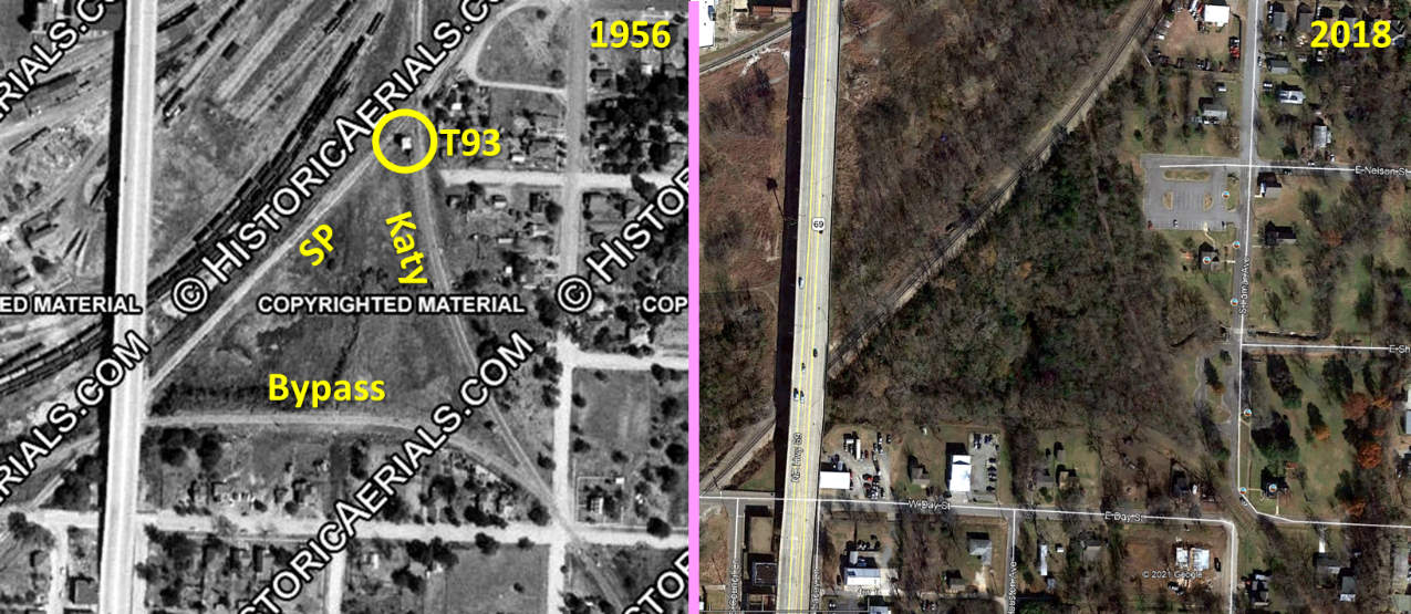
Below: These overhead
images of the Tower 93 area are from 1956 ((c)historicaerials.com) and 2018
(Google Earth), respectively. The 1956 view shows that the tower sat south of
the SP/Katy crossing. The tower was within a triangle of tracks formed by the SP
line into Denison on the west, the Katy line to Greenville on the east, and the
Katy freight bypass on the south. Of those lines, only the former SP line
remains intact, now owned by Burlington Northern Santa Fe (BNSF), the
successor to the Frisco. UP
(SP's successor) did not need the SP tracks as they had the former Katy / T&P
tracks from Ray Yard to Fort Worth as their primary north/south route.
From downtown Denison, Frisco had its own line to the Red River bridge that ran
west of the Katy's main line. The Katy tracks from downtown to the bridge have
been abandoned, but the Frisco tracks remain intact, now owned by BNSF and used
for its traffic between the Red River bridge and Dallas/Ft. Worth via Sherman
and Carrollton.
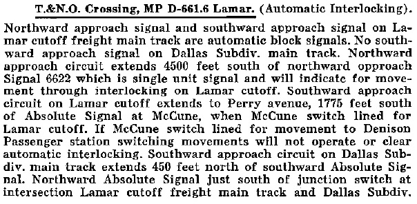
Harry Brown explains the nature of the electro-pneumatic interlocker in
his personal recollections of visiting Lamar Tower...
If you were standing at the south end of the passenger
platform at the MKT Denison Depot, you could have seen the now-gone
tower several hundred feet south of Main Street. The tower controlled two crossings, the junction of the freight
cutoff and the Dallas Sub main (known as Lamar Switch), and the
connection between the T&NO (SP) and Katy used by T&NO
(SP) and Frisco passenger trains going to/from the Katy Depot.
One of the crossings was adjacent to the tower where the SP crossed
the MKT Dallas Subdivision. The other crossing was about a mile
SE of the tower where the T&NO (SP, and tenant Frisco) crossed
the Katy's freight cutoff near the south end of the Austin Avenue/US
Hwy 69 viaduct.
As a kid, times without number I heard in the
middle of the night Frisco's Tulsa-bound Black Gold coming in
on the T&NO (SP) from Sherman whistling for the connection:
one long, one short, one long, one short. A while back, my pal Joe Pike mentioned his and our visiting
and watching the operator many times. I also visited the tower
when my cousin substituted for a regular operator. Joe also mentioned
carrying orders down the track to the freight cutoff junction
switch to hand up to outbound freights. This junction, which was
right in front of the Eisenhower house at Day Street and Lamar
Avenue, was called Lamar, hence the tower was called "Lamar" on
the Katy (but "Tower 93" on the T&NO) even though the switch was
a few hundred feet away.
Lamar was an electro-pneumatic plant; i.e., the
turnout motors were powered by compressed air rather than electricity
or armstrong push/pull rods. There was a large air compressor
and air storage tank downstairs in the tower. Compressed air lines
ran from there to the turnouts. These air lines were encased in
wooden conduits atop concrete posts. I wish I had a dime for every
time I managed to walk atop the full length of one of the conduits,
and $1000 for every time I slipped and fell astride one. Oooooooh!!! The interlocking machine was equipped with enough handles to
control all the switches and signals in the plant. To move a handle,
you twisted a knob at the end of the handle and moved it right
or left. The top of the machine was covered with very heavy glass
through which you could see the ingenious design of sliding bars
arranged to make it physically impossible to clear conflicting
routes at the same time.
All those trees that line the BNSF (former SP) tracks in the
vicinity are the result of years of neglect. No trees grew along
the tracks in the old days. Katy once had a huge oil storage tank
in the triangle surrounded by the Dallas Sub, freight
cutoff, and T&NO (SP). From Lamar Switch, the freight cutoff ran along the south side
of Katy's car shops complex, then curved to join the double-track
Ft. Worth Sub main from downtown at a turnout called Daley (later,
McCune) a few feet east of the Armstrong Avenue grade crossing.
Most of this r-o-w still can be seen. Just west of Armstrong Ave.,
a crossover let incoming freights get to the right hand track. In the old' days, Armstrong Ave. was the route of US75 south
of Main St. In addition to all-day traffic of freights, varnish,
and transfer runs, the heavy motor traffic at the grade crossing
kept the rails well polished. This resulted in the frequent spectacle
of a Katy Mike coming off the cutoff losing its grip in the middle
of the grade crossing. Picture this: An inbound freight from the
Dallas Sub would have to slow to a crawl while the head-end brakeman
made his way from the cab along the running board and down to
the pilot footboard, then hop off and run ahead, unlock and open
the Daley/McCune switch, dash across the Avenue while hoping that
motorists would obey the single wig-wag, unlock and open both
crossover switches, and, finally, get back aboard. The rear-end
brakeman would have to put all the switches back to normal and
lock them, keep from getting hit by a motorist, and run to catch
the caboose. It was slightly upgrade approaching Daley on the
cutoff, so between that and having to drop down slow enough to
let the head brakeman off, the engineer's skills were put to the
test to keep forward motion over the slick rails.
Joe Pike recalls the tower and other sites nearby...
One little incident which comes to mind regarding
the Armstrong
Ave. (old US-75) crossing: Once upon a time, in the late 1920's
or early 1930's, a southbound freight engineer got just a little
ahead of himself when he hit the leg around the car-shops to the
Dallas main. As a result two cars derailed at the intersection,
separated from the rest of the train and turned over on their
sides. They were gondolas that were full of raw cane-sugar. Sugar
was scattered everywhere, followed by local "looters"
followed by a plague of ants. This grade crossing forever afterward
-- maybe even today -- is known locally as SUGAR BOTTOM.
Another strong memory and bright mental picture
is when, as
a teenager, I would walk (or ride my bike) down to Lamar Tower
at eight or nine o'clock at night and spend two to
three hours there with the operator, Mr. Thurmond. He was an older
man who had lost a leg in "railroad service". Instead
of pensioning him off, the Katy found a job for him. This was,
I suppose, common to all railroads of the era, as you saw disabled
veterans manning crossing shacks and fulfilling other duties when
they could no longer be employed in "active" service. Anyway, I can still see the Prince Albert tobacco can behind
the sounder for the telegraph key; the pad of order-forms, the
single bright light over the desk, the lighted green/red dots
on the display board above the levers, and all the rest. Often, when a set of orders
needed to be handed off to a train
at the tail of the wye a quarter mile a way, he'd give me the
Y-hoops and I would trot down to wait and hand them up (very "unofficial"
naturally). Of the two dozen or so times I did this I NEVER missed the cab or caboose ... Then the railroad installed
the stick-holder racks that replaced manually passing the orders. You've got to stand two feet from a thundering steam locomotive
(going 20 mph) to appreciate teeth-grinding fear, knowing that
you had to remain absolutely still until the fireman or engineer
had swept the string onto his arm. Then back to the tower; the clicking of the sounder, and listening
to Mr. Thurmond yelling at the dispatcher (DS) over the phone. I suggested
that Mr. Thurmond could stick his head out the window and with
the same volume, be heard by the DS a scant mile away on the second
floor of the Denison depot!
The relatively high number of functions implemented by
the Tower 93 interlocker is indicative of the track complexity nearby. Though it
is not obvious in the 1956 aerial image above, there was a connecting track
immediately west of the tower that allowed SP passenger trains to access the
Katy tracks north of the tower to reach Union Station. The KO&G was never listed
by RCT as having any involvement with Tower 93, but this may have changed after
1930; by 1940, one of the whistle codes for Tower 93 operators requested
movements to and from the KO&G transfer track.
 |
Left:
In June, 1940, SP issued an employee timetable for the Texas & New
Orleans (T&NO) Railroad, SP's primary operating company in Texas (into
which the H&TC had been merged in 1934.) The timetable had this chart of
whistle codes for specific requests to the Tower 93 operator. |
 |
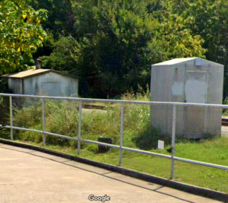
Left:
This image from a Katy employee timetable indicates that by 1964, the
interlocking for the "Lamar cutoff" (freight bypass) crossing of the SP
tracks is automatic.
Right:
In 2019, two "walk-in" cabinets still sat
at McCune (named for W. H. McCune, Katy's "Road Foreman for Engines") in this Google Street View from near the Armstrong
Ave. grade crossing. The west switch for the Lamar cutoff was located here,
where Harry Brown described the challenge of crossing Armstrong Ave.
fast enough to maintain speed on slick rails but slow enough to allow
time for the brakemen to manage the crossover switches. |
 |
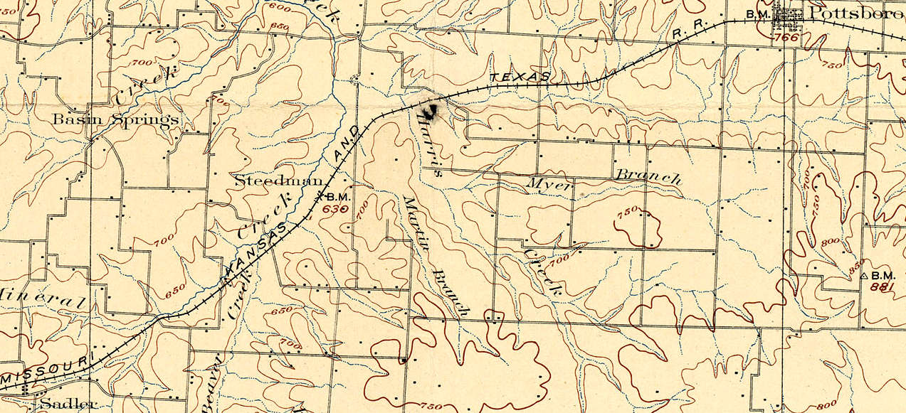
Above: The construction of Lake Texoma during the early
1940s affected rail lines in its vicinity. The flooding of tributary creeks to
the Red River threatened to put the Katy tracks underwater between Pottsboro and
Sadler near Big Mineral Creek. The tracks were rerouted south of this area,
which became the Big Mineral Arm of Lake Texoma. In 1946, the
Hagerman Wildlife Refuge was
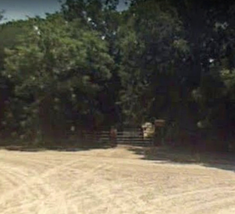
created and a section of the Katy ROW was able to be reused as a road within the refuge. At the south end of this road, the former
Katy ROW is gated (above right)
for non-motorized use (2008 Google Street View) and continues as a public trail
all the way south to the tracks. Concrete bridges built by the Katy over creeks
along the trail still show embossed mile markers testifying to their origin. The refuge was named for the town of
Hagerman which was inundated by the lake. A passage in the Handbook of Texas
says the town "...established in 1880 was called Steedman until 1909. When the
tracks of the Missouri, Kansas and Texas Railroad reached the community in 1909,
its name was changed to Hagerman, to honor railroad attorney James Hagerman."
The 1909 date is confusing. RCT records and other sources establish that the
Katy's tracks between Pottsboro and Sadler were laid in 1879 under the charter
of the Denison & Pacific. The Handbook of Texas confirms that both Sadler
and Pottsboro were
named for landowners who donated land in the late
1870s for the ROW. And a 1902 USGS topographic map (below)
shows the tracks passing through Steedman. Though Steedman was
renamed for Katy attorney Hagerman, this change does not appear to have been
prompted by Katy tracks arriving in 1909.
Over many decades, railroad industry consolidations and
other changes in transportation caused three of the rail lines into Denison to
be abandoned. Although the DB&NO abandonment in 1928 might qualify as the first,
it did not actually affect any tracks in Denison since both the KO&G tracks and
the Katy line from Greenville (the DB&NO's two routes for reaching Denison)
remained in service. Two lines were abandoned into Denison in 1965: the
aforementioned KO&G when it was taken over by the T&P, and the T&P's Denison &
Pacific Suburban line from Sherman. In 1988, the Katy was acquired by MP. MP had merged the T&P
in the previous decade which included the T&P main line from Sherman to Texarkana that passed
through Bells. The Katy line to Greenville crossed
at Bells, so the junction was reworked to route the tracks from Greenville onto
the MP line to Sherman and the line from Bells to Denison was abandoned. This
rendered the freight bypass south of Tower 93
unnecessary and removed the need for the Tower 93 interlocker (which had already
been automated.) The last to go was the Katy branch from Denison to Sherman,
abandoned in 2003.
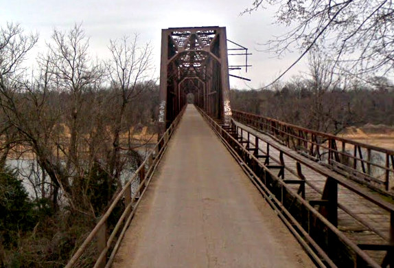

Above: the two Red River
bridges that served Denison: (left) the KO&G bridge at Carpenter's Bluff,
looking across to Oklahoma (note the original driving lane attached to the
bridge); and (right) the Katy bridge north of Denison (Google
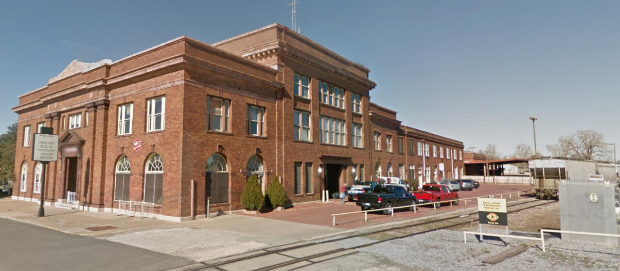
Street Views) Below: The
Union Station passenger depot in Denison no longer serves passengers, but it
does have office space in use for various purposes. The
Red River Railroad Museum is
located nearby. Without passengers to serve,
the Katy tracks north to the bridge became unnecessary and are abandoned 0.7
miles north of the station. The tracks in this 2014 Google Street View are in use
by the Dallas, Garland & Northeastern (DG&NO) Railway. DG&NO and its sister, the
Texas Northeastern (TNER) Railroad, both owned by Genesee & Wyoming, operate
many of the former rail lines that have been deprecated to secondary status such
as between Denison and Dallas via Sherman, Bells
and Greenville using former SP, T&P and Katy tracks.