Texas Railroad History - Tower 59 - Waco
A Crossing of the San Antonio & Aransas Pass Railway and
the Missouri - Kansas - Texas Railroad
During 1887-1891, the San Antonio and Aransas
Pass (SA&AP) railroad built a line from Yoakum to Waco, the furthest north
the railroad would ever reach. The line entered Waco on the southeast side of
town, culminating in a sweeping curve to the west paralleling the south bank of
the Brazos River as it reached downtown. The line extended through downtown past
the SA&AP passenger depot and ended a few blocks further west. A block east of the
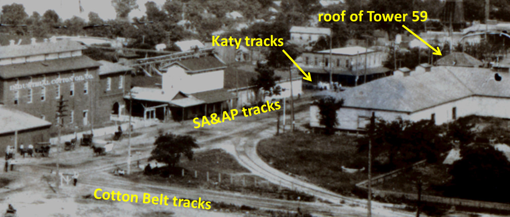
SA&AP passenger depot, the line crossed the Missouri-Kansas-Texas (MKT, "Katy") railroad, a short distance south
of the Katy bridge over the Brazos. Tower 59 was built in the southeast
quadrant of the crossing and
approved for operation by the Railroad Commission of Texas (RCT) on November 21, 1904.
It was listed in RCT records as a "Mechanical" interlocker with 26 functions.
The "Mechanical" description implies a manned structure, likely a 2-story tower,
since unmanned mechanical interlockers were mostly referenced as "Cabin" interlockers in RCT documents.
Although a complete photo of Tower 59 has not been located, photographic
evidence of the tower has been discovered confirming its design as a traditional
2-story tower.
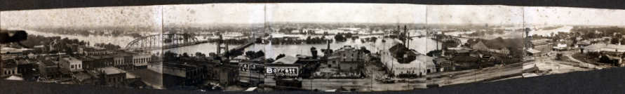
This panoramic photo of the Brazos River flood of 1908 (above) is provided by
the
BaylorUniversity Libraries Digital Collections Blog. A
magnification of the far right side of the high resolution version of this photo
is annotated below to highlight the rooftop of Tower 59. This
roof design reveals Tower 59 to be a traditional 2-story tower. The roof profile
is very common among Texas interlocking towers.
[Hat tip, Dennis Hogan]
Below: This undated postcard from the collection of Dan
Whatley shows a glimpse of Tower 59 at far left (green circle).

Below: Roughly three decades after the 1908 flood, railroad magnate John W
Barriger III took this photo from the rear
platform of his business car as his train proceeded south through Waco. The view
is north along the Katy tracks with
the Brazos River bridge in the distance. The site of Tower 59 was to the right,
approximately where the car is parked.
The car at left is traveling on the street that was the SA&AP right-of-way. It
does not appear that the SA&AP tracks
were still intact when this photo was taken in the late 30s or early 40s.
Obviously, the tower had been removed by this
time, but precisely when is unknown.

Finding traces of Tower 59's existence has
proven difficult. It does not appear on the 1899 Sanborn Fire Insurance Map of
Waco, nor does it appear on the 1926 edition (and unfortunately, there are no
Sanborn maps of Waco between these dates). The SA&AP was acquired and
merged into Southern Pacific's system. The SA&AP tracks into the Waco area
remained in use by SP until the line was abandoned in 1967. Long before then, the
SA&AP tracks into downtown had been removed, but the specific year and the
impetus for doing so have not been determined.
Research by Bradley and
his dad John Linda at
Waco city hall initially came up empty, as discussed in this email dated 9/10/2005:
...Dad and I made it down to the basement of City Hall and looked at the 1929 and 1955 aerials of Waco.
Neither aerial shows 59 or 144. We think we can make out 8 in both (21 is distinctly evident).
... With regards to Tower 59, Dad said he thinks the SA&AP freight house near the SSW/SA&AP crossing
had a second story on it, that looked like a tower. Perhaps this is Tower 59? The building has long
been demolished. My grandfather seems to recall that this area where the SA&AP crossed the MKT
and SSW was known as Brazos Jct, but he hasn't come across the photo of it in his collection yet.
Subsequently, Bradley had some success in confirming the existence of Tower
59. In an email dated 9/16/2005, he wrote:
Regarding the continuing saga of Waco
Interlocking towers, I am now able
to confirm a tower existed
at the MKT/SA&AP diamond in Waco. We went down
to Temple this evening to set up the NMRA booth at the
Temple Train Show.
We got done, and I started wandering the hall. I found my timetable source
there,
and laying on his table were, for $8 a copy, copies of a "Side
Track Record" of the SA&AP between Adel
and Waco. I've attached the photo
of one of the two pages on Waco. It shows a "Signal Tower" at the
MKT/SA&AP diamond (an 89 degree, 55 minute crossing). There are two dates
on this
page, "Nov 23, '18 ELV" and "-b- Jan. 26, 1921...

Above: This is a page from Side Track Records of the
SA&AP between Adel and Waco showing "Signal Tower"
(at left) at the junction of the SA&AP and the MKT railroads. In the photo,
south is up. Photo by Bradley Linda.
The Katy tracks remain intact and see
significant traffic, now owned by Union Pacific. The SA&AP tracks and the Cotton
Belt tracks have been abandoned, although the Cotton Belt bridge over the Brazos
remains standing.
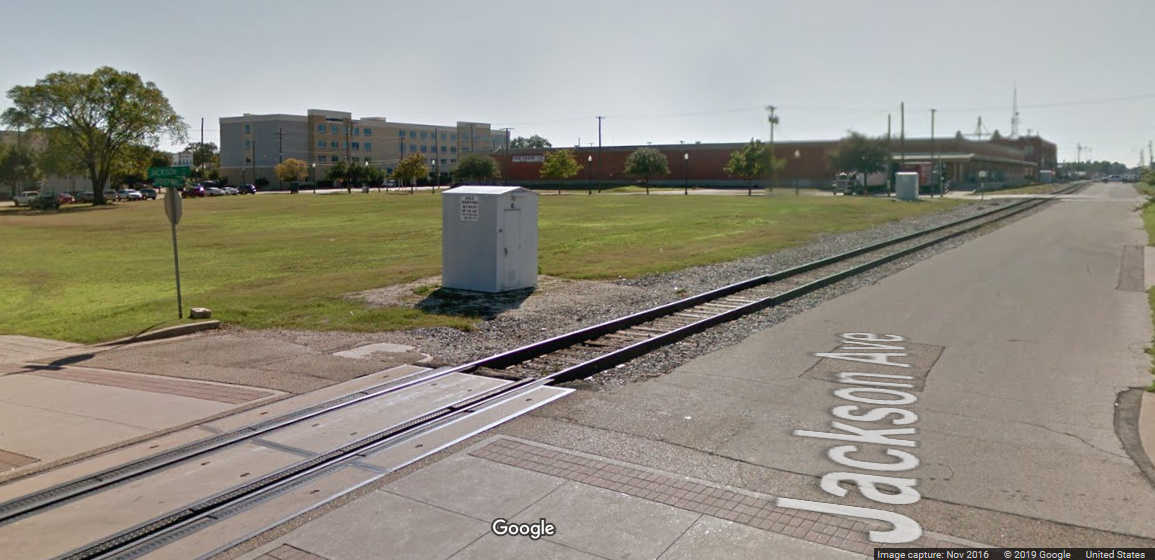
Above: This Google
Street View image from 2016 shows an open greenspace with a railroad signal
control cabinet where Tower 59 once stood.
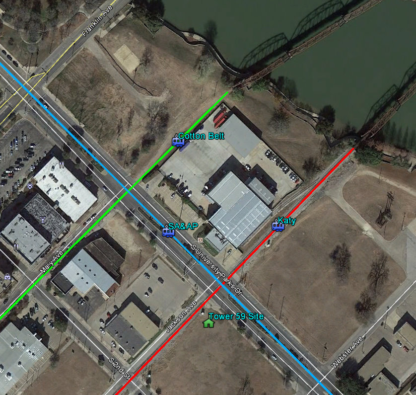
Above: The SA&AP (blue), Katy (red) and Cotton Belt (green) rights-of-way are
annotated onto this Google Earth satellite image of the riverfront area
of downtown. The south extensions of the two railroad bridges over the Brazos
River are visible at the top of the image. Only the
Katy tracks remain in place.