Texas Railroad History - Tower 108 and GH&H Tower - Houston (Bonner's Point)
A Crossing of the Houston & Texas Central, the Galveston,
Houston & Henderson, and
the Missouri-Kansas-Texas railroads
.jpg)
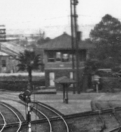
Above Left: Southern Pacific
photographer "La Lumiere" took this photo facing southwest, capturing the
sunny east face of Tower 108 along with the shady north face. The photo was
taken in November, 1918, seven months after the tower was commissioned. Note the palm tree planted at the northeast corner of the tower. (Ken Stavinoha
collection) Above Right:
Steve Hesse located this undated image of the west face of Tower 108 in a larger photo at the Houston
Metropolitan Research Center. The palm tree is bigger, but unfortunately, it's
in the northwest corner, so it was either transplanted or it's not the same tree
(hat tip, Mark Elvig.) From these two photos, we can summarize the lower floor
faces of the tower: east face, door and window in center; north face, single
window in center; west face, separated door (north) and window (south); south
face, staircase and upper floor door (east). (Houston Public
Library, used with permission.)
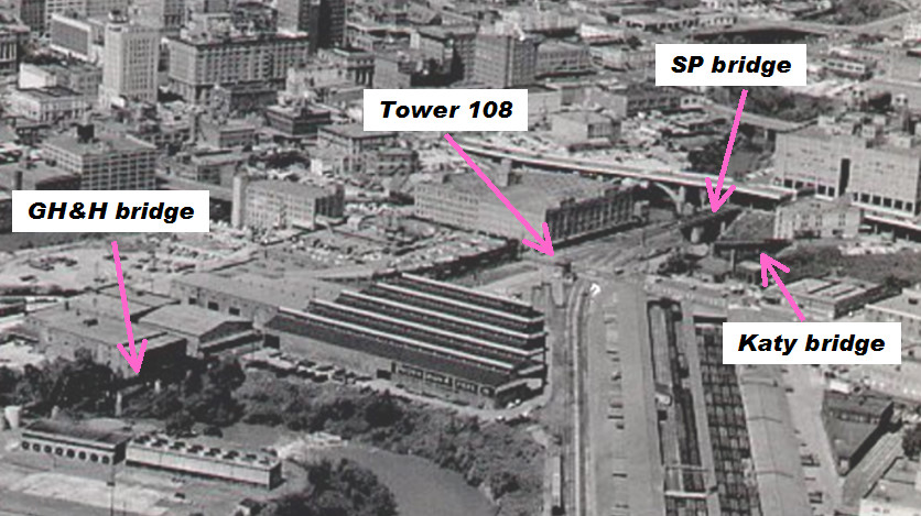
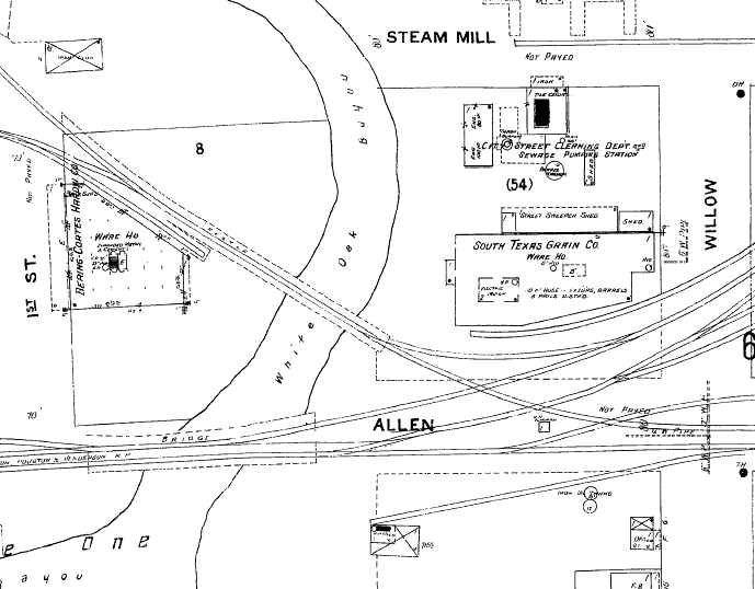
Above Left: area map
of Bonner's Point Above Right:
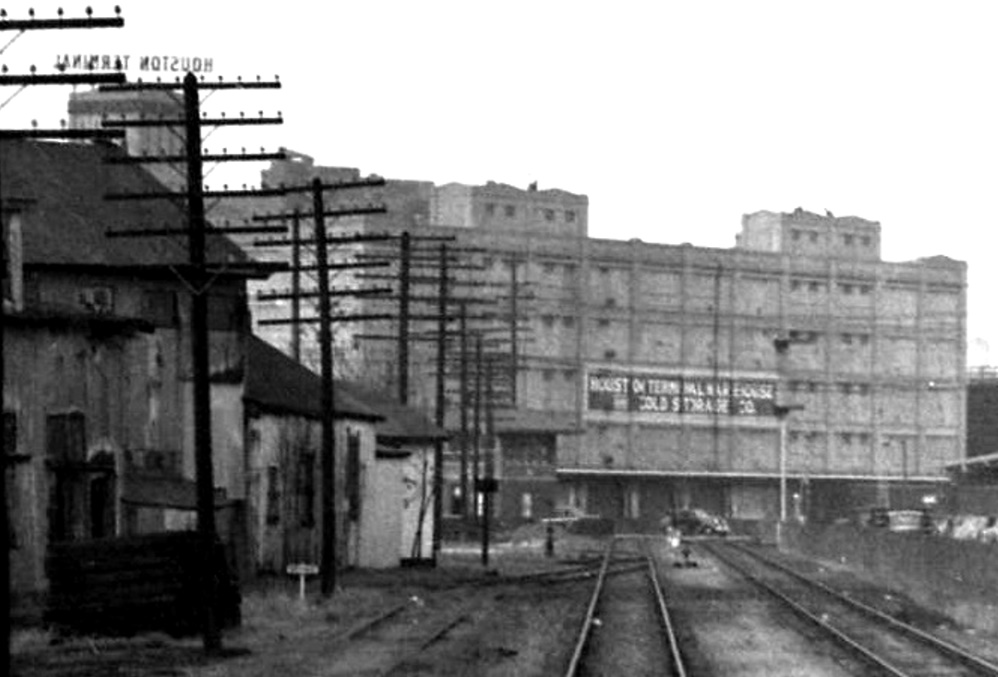
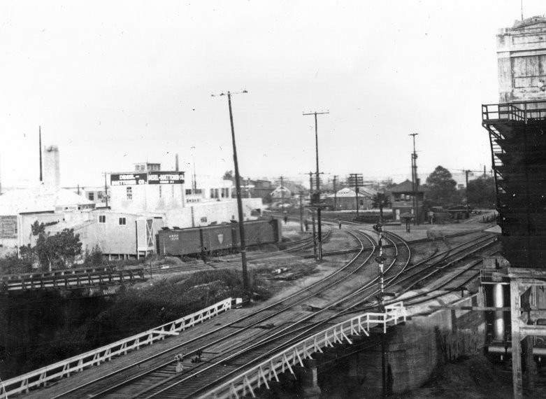
This photo taken by John W Barriger III in the 1930s shows a glimpse of Tower
108 where the tracks curve near Houston Terminal Warehouse Cold Storage Co.
Barriger was
facing southwest at the rear of his business car as
his train proceeded northeast toward Tower 26 and
Englewood Yard. Note the single window on the north
side of the tower, also visible in the "La Lumiere" photo
further above. There are no apparent palm trees. (John W Barriger III National
Railroad Library)
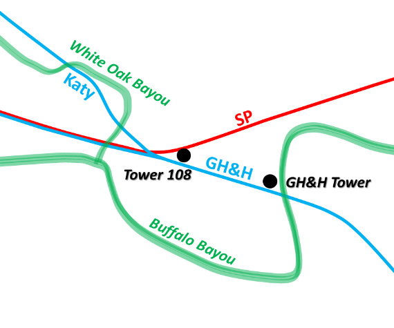
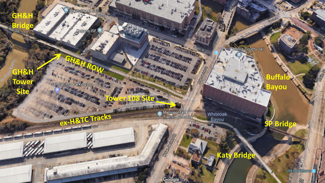
The Galveston, Houston & Henderson (GH&H) Railroad
was founded in Galveston in 1853, and by 1859, had completed a line into Houston
ostensibly headed for the northeast Texas town of Henderson. At about the same
time, the Houston & Texas Central Railway (H&TC,
originally chartered as the Galveston & Red River Railway), began building northwest from
Houston toward the rich agricultural area of the Brazos River, completing 81
miles to Millican by 1861. After the Civil War, H&TC expanded rapidly, reaching
Dallas in 1872 and Denison
at the Red River in 1873. Meanwhile, a series of financial
problems and court battles for GH&H eventually resulted in two other
railroads having equal joint ownership of it: the Missouri-Kansas-Texas
(MKT, a.k.a. "the Katy"), and the International-Great Northern (I-GN). It was in
the interests of GH&H and H&TC to have a connection in Houston to provide
service from central and north Texas to Galveston and its port. This connection
was made north of Buffalo Bayou using a shared east/west bridge over White Oak
Bayou located immediately north of the bayou's confluence with Buffalo Bayou. At the
time, this area was apparently known as Bonner's Point, but relatively few references to
this geographical name have been found. GH&H used the shared bridge for a
transfer track to reach the H&TC passenger station and other facilities west of
the bayou while H&TC used the bridge to reach facilities east of the bayou that
were owned by Southern Pacific (SP), which had gained control of H&TC in 1883.
When the Katy reached Houston from the west in 1893, it
built a passenger station near White Oak Bayou and built a bridge over the bayou
to connect with GH&H. The Katy bridge was located a short distance north of
the shared GH&H/H&TC bridge. At some point after 1907, GH&H stopped using the shared
bridge and it became exclusively an "SP bridge". East of both bridges, the Katy, GH&H and H&TC
junction at Bonner's Point was undoubtedly a busy rail junction, but it was not
among the early interlockers established in Texas. The proximity of the two
passenger stations, the two bridges over White Oak Bayou, and a nearby GH&H
bridge over Buffalo Bayou meant that trains passing through this area operated at
very slow
speeds. Hence, stopping at the junction to cross an opposing track (as required
by state law for uncontrolled crossings at grade) was not a
significant time penalty. By 1916 however, the opening of
Houston Union Station
(in 1911), the addition of industry tracks near the junction, and the substantial increase in volume and complexity of rail
movements through Bonner's Point resulted in the need for an interlocker. The
original plan called for a tower to be operational by April 18, 1917, but steel
shortages caused by World War I delayed the tower a full year. Tower 108 was
finally commissioned for operation at 2:00 pm on April 6, 1918 to control the Bonner's Point
crossing with a 32-function electrical interlocker serving the GH&H, MKT and
HT&C railroads. In 1923, the Railroad Commission of Texas (RCT) officially
reported that the function count for Tower 108 had decreased to 30, and the GH&H
was no longer listed as a participating railroad. In 1926, the function count
increased significantly to 48 functions, and it remained this way through the
final RCT list published in 1930.
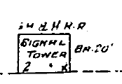
According to Sanborn Fire Insurance Co. maps of
Houston, a 2-story "GH&H RR Signal Tower" also existed on Bonner's Point at the west end of the GH&H
bridge over Buffalo Bayou, approximately 800 ft. east of Tower 108. This GH&H
tower is depicted on the 1907 Sanborn map ten years before the construction of
Tower 108. The function of this tower is unknown, but its proximity
to the GH&H bridge and the lack of any other obvious purpose implies an association
with operations over the bridge. It seems likely that its function would have
been subsumed into Tower 108. References to this tower have yet to be found in
the RCT archives at DeGolyer Library, Southern Methodist University, and it is
likely that it did not have an RCT-authorized function.
Above: This photo shows Tower 108 in the background, overlooking the rail junction at Bonner's Point. The camera
is facing northeast with the double track SP bridge in the foreground. As in the
snippet further above, the palm tree dates the photo to at least the late 1920s
(Houston Metropolitan Research Center, Houston Public Library, used with permission.)
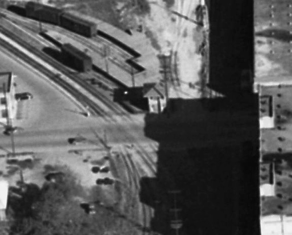
Below: This excerpt from an
undated photo in the Texas Dept. of Transportation archives appears to be late
1960 or early 1961 based on freeway construction that appears in the larger
photo. The view is to the southwest, and Tower 108 is clearly visible as are the
bridges over Buffalo Bayou and White Oak Bayou. It is possible that the "GH&H
Signal Tower" is also visible as a small white dot to the right of the GH&H
bridge.
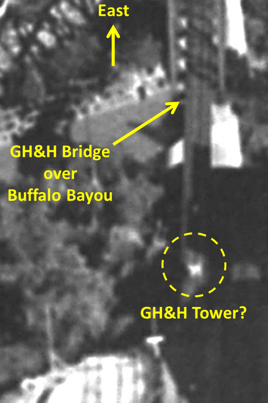
Below Left: Tower 108 is in the center of this image extracted from a larger
digitized photo provided
by the
Houston Area Digital Archives of the Houston Public Library. The photo was
taken
in the 1940s by R. L. Browning facing east.
Below Right: Farther east, the same photo
appears to provide a glimpse of the GH&H Tower.
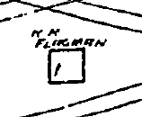
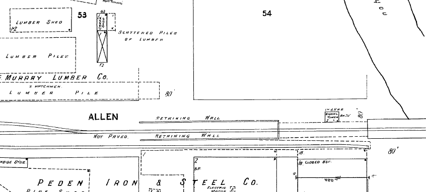
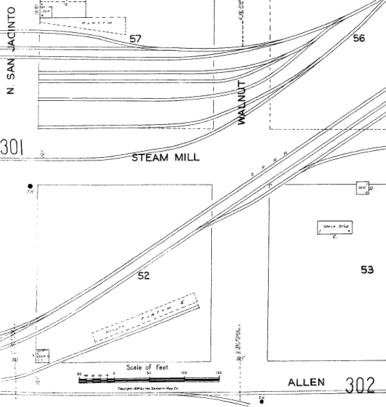
Above: The 1907 Sanborn map shows both the
shared H&TC/GH&H bridge
(lower) and the Katy bridge (upper) across
White Oak Bayou immediately north of its confluence
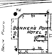
with Buffalo Bayou. Where
the railroads cross in the middle of Allen Street, a one-story "R R Flagman"
structure is shown (magnification at center). The flagman presumably
served a
function that was later incorporated into Tower 108 (and this is the
only "R R Flagman" found so far on Sanborn maps.) Willow St.
runs north/south and was renamed North San Jacinto sometime between 1907 and
1924 when it was joined with San Jacinto St. by a bridge over Buffalo Bayou. The
Bonner's Point Hotel (far right) was located at the southeast corner of Allen
St. and Willow St. (noted as "brick paved".)
Below: Continuing east along Allen St., the 1907 map shows a 2-story "GH&H
RR Signal Tower" at the west end of the GH&H bridge over Buffalo Bayou
(magnification
at right). It also appears on the 1924 Sanborn map.
Below: The 1924 Sanborn map shows that Tower 108 had been constructed at the northeast corner of
Allen St. and N. San Jacinto St. in the lower left corner of
the image. The
mapmaker depicted the tower as a 2-story office (magnification at right).
Neither Tower 108 nor the GH&H Signal Tower survived to the
present and
their fates are unknown.
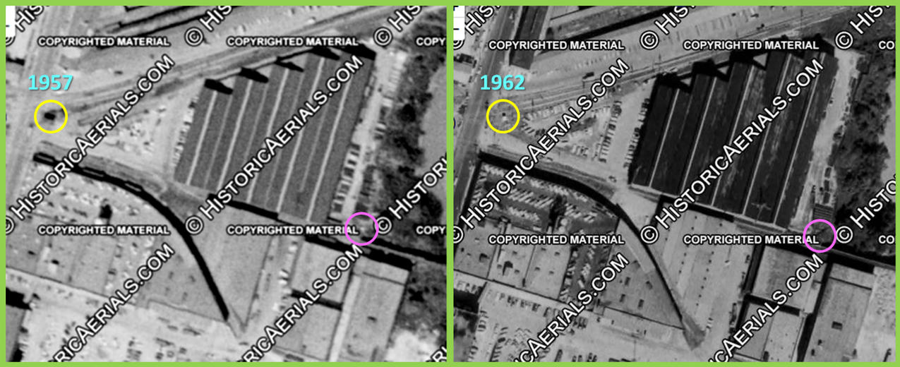
Below:
These two images ((c)historicaerials.com) date from 1957 (left) and 1962 (right)
showing the apparent demise of Tower 108 (yellow circles), replaced by what
appears to be a smaller, white equipment cabinet. Although changes in the
vicinity of the GH&H tower location (pink circles) also occurred, it certainly
appears that by 1957, the tower was already long gone, replaced perhaps by an
equipment cabinet that is no longer apparent in the 1962 image.
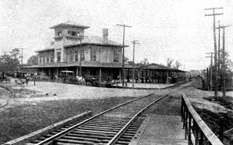
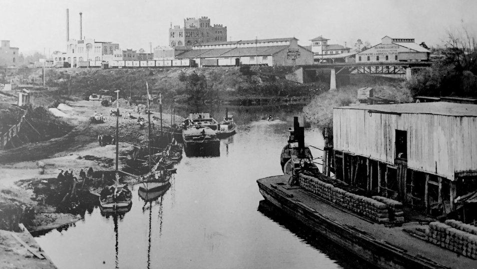
These two
photographs supplied by Bruce Blalock show near and far views of the original
1893 Katy depot. Bruce explains: (above)
"This is the original station built by the Katy in 1893. The later one was built
virtually in the same location and completed on February 1, 1914. On the left
side is a team track and road where the M&M (Merchants & Mechanics) Building
stands, which is the University of Houston Downtown campus. The photographer is
standing on the Katy's trestle over White Oak Bayou, which will be replaced in
later years with a steel girder bridge. The road running left to right will
become the original North Main Street of Houston. The other image (below)
shows Buffalo Bayou as it looked in the 1890s. Allen's Landing is on the left
and the bayou curves around to the left going upstream. The railroad bridge is
the Houston & Texas Central crossing of White Oak Bayou at the confluence of
those two streams. This line would eventually become the Sunset Route with
Southern Pacific's Grand Central Station built near the left edge of the image.
The Katy's first depot can be seen just above the left bridge pier. The tugboat
on the right is handling a barge of baled cotton."
Bonner's Point, 2006
(photos by Jim King)
 |
|
 |
|
|
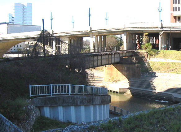
Above: Facing west, the track on the SP bridge sits off-center
(to the south) on the concrete support because the track on the north
side was removed. |
|
Above: No longer with rails, the Katy bridge appears to
have been modified for pedestrians. In the past, the Katy depot would have
been visible in the distance. |
|
| |
|
|
|
 |
|
 |
|
|
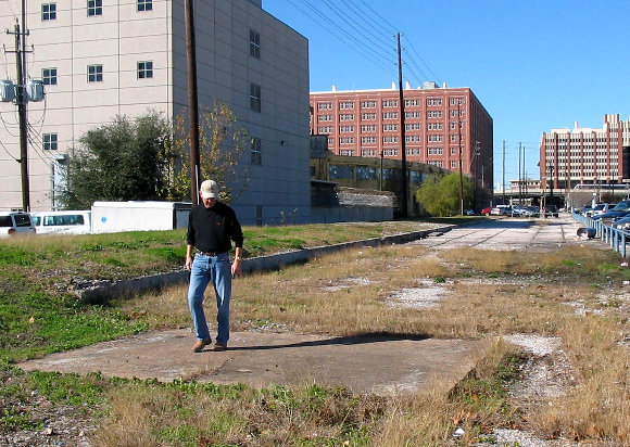
Above: John Davis examines the foundation of the GH&H
tower at the west end of the Buffalo Bayou bridge. The small retaining
wall is shown on the 1907 Sanborn map. |
|
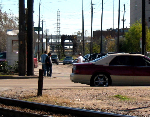
Above: East on Allen St., the GH&H bridge over Buffalo
Bayou is visible at distance. Tower 108 would have been behind the two
utility poles. Might these be the same two utility poles visible in the
photo at the top of the page? |
|
| |
|
|
|
Bonner's Point, 2019
Simulated 3D View
Above: This simulated 3D view
of the area faces south-southeast. The only remaining rail line, now owned by Union
Pacific (UP), crosses west to east across the SP bridge, passes the
Harris County Jail, and curves back to the northeast toward
Englewood Yard. The
Katy Bridge now hosts the White Oak Bayou Greenway Trail while the former GH&H
right-of-way hosts the Heights Hike & Bike Trail.
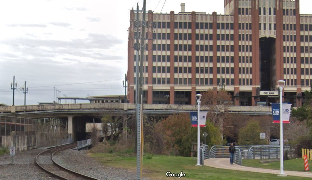
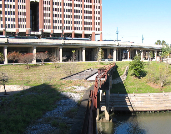
Bonner's Point, Google Street View 2019
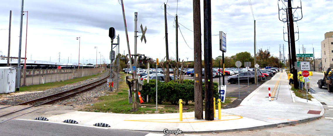
Above: There's a green hedge and a crepe myrtle growing
where Tower 108 sat. The rectangular concrete (or brick) outline surrounding the
hedge on all sides suspiciously resembles the perimeter foundation of Tower 108
but is probably too small. The red and white bollard marks the Heights Hike and Bike Trail which now
occupies the GH&H right-of-way proceeding east toward Buffalo Bayou.
Below: Looking west from the
same location, the SP bridge remains in place. The pedestrian is departing the
former Katy bridge on the White Oak Bayou Greenway Trail. Whether the actual
Katy bridge structure was used for the trail bridge is unknown.