Texas Railroad History - Tower A -
Galveston (36th Street)
A crossing of the
Galveston, Houston & Henderson Railroad; the Gulf, Colorado & Santa Fe
Railway;
the Galveston, Harrisburg & San Antonio Railway; and the Galveston
Wharves Co. tracks
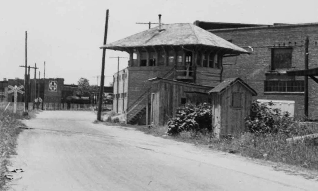
Above: An optical illusion makes Tower A appear embedded
in the building behind it. Viewed from this perspective, the front left vertical edge of the tower
(where the staircase begins at ground level) happens to align perfectly with the
wall and roofline of the building in the background. Reinforcing the illusion,
the building has a 135-degree angled wall instead of a 90-degree corner. An exchange track behind the tower is not
readily apparent, but its
location can be discerned from the crossbuck at left. The track is barely
visible crossing the road from the crossbuck toward the building and passing
behind the utility pole to the left of the tower. It continued straight, passing behind
the tower between the right side utility pole and the windowed brick wall of the
building. (photo c.1940, Rosenberg Library,
Galveston and Texas History Center)
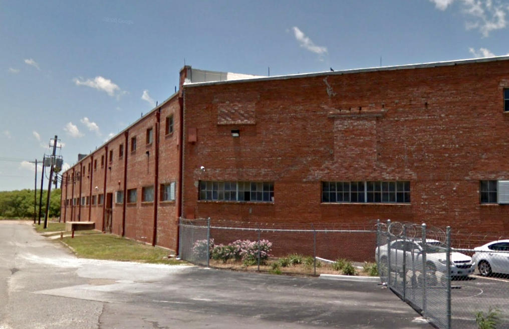
Below:
Google Street View (May, 2017) shows approximately the same view as above. Some
of the window openings have been bricked over and the track that ran behind the tower
no
longer exists. The date and disposition of Tower A's demise has not been determined, but the
1960s seems likely. It is known to have existed in 1958 but it does not appear
on historic aerial imagery from 1969.
Tower A was located in Galveston at a junction of the Galveston, Houston &
Henderson (GH&H) Railroad, the Gulf, Colorado & Santa Fe (GC&SF) Railway, the
Galveston, Harrisburg & San Antonio (GH&SA) Railway and private tracks
of the Galveston Wharves
Co. Although it had been known to Galveston railroaders for nearly
three decades, formal approval of the Tower A interlocking by the Railroad
Commission of Texas (RCT) did not occur until 1926. RCT elected to retain the
existing (albeit unofficial) name given to it by Santa Fe rather than assign a number as they had for
all other interlockers. RCT's table of active interlockers published December
31, 1926 was the first to list Tower A. It described the interlocker as a
mechanical plant having 52 functions and a service date of "Prior to 1902." The
list published December 31, 1927 revised Tower A's service date to simply
"1898". The final such list published by RCT, dated December 31, 1930,
raised the function count to 54 but all other information remained unchanged. Since Tower A had lacked an official designation from RCT for thirty
years, it had come to be referenced by local railroaders in several different
ways, and the railroads tended to continue using those names rather than
universally adopt Tower A.
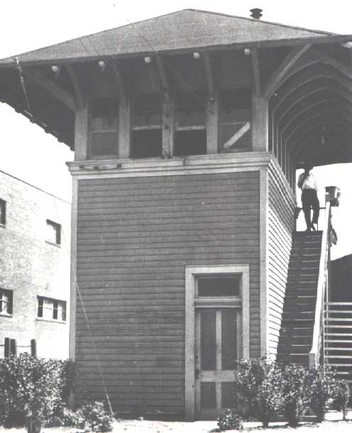 |
Left:
This photo of Tower A, date unknown, is from the Kansas State Historical
Society (courtesy William Osborn collection.)
Above: Frank Perez
is a retired railroader who began his career with Santa Fe as an
operator in Tower A in 1950. Frank tells of his first day on the job,
having engineers whistling at him from all directions. He was so rattled
that he started to bolt from the tower to head home when he heard the
phone ring. He went back upstairs to answer it and it was his supervisor
wanting to know why all those trains were whistling for signals! When
Frank told him he didn't know what to do, the supervisor said to let one
through at a time. Frank followed the instructions and had a successful
career in the tower for many years.
When Frank worked as a relief
operator (1950 to 1958), Arthur Wade was first trick operator, H.E.
Smith had second trick, and a Mr. Clifford was the third trick operator.
Frank recalls that a signal maintainer named Boyd was killed when a
train derailed and crushed him against a corner of the tower. Thanks to
Frank for providing details about Tower A's operations. In retirement,
Frank has supported the Galveston Railroad Museum as an electronics
technician. Frank is sure that the person standing on the tower porch in
the photo at left is H. E. Smith. Frank details that the
interlocker levers were located in the middle of the room and were aligned
parallel to the outside steps. |
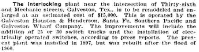
Right: Lacking a
commonly accepted name by which to reference Tower A,
Railway Age (October 27, 1905) simply reported a remodeling
of the "...interlocking plant near the intersection of Thirty-sixth and
Mechanic streets...".
Santa Fe built Tower A c.1897 near the
hypothetical intersection of 36th and Mechanic streets, hypothetical because 36th
Street is not known to have ever extended all the way to Mechanic St.
The intersection appears to have existed only on the official plat of Galveston.
Tower A had the first interlocking plant in Texas; this was presumably the rationale for the 'A' name given by Santa
Fe. |
 |
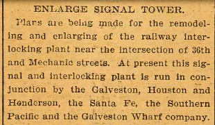
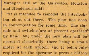
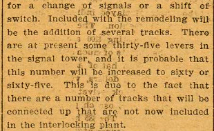
Below: The
Galveston Tribune
of October 16, 1905 reported on the plan to enlarge the tower (again, not identified by name, only by location.)
The Houston Metropolitan Research Center has archived Santa Fe documents
pertaining to the "rehabilitation" of Tower A in the 1943-44 timeframe, but the
documents have
not been reviewed.

=======================================================================
=======================================================================
=======================================================================
|
Left, Top: Since a tower number had
not been assigned by RCT for decades, the railroads had adopted their
preferred tower references in their employee timetables (ETTs). This
table of whistle codes from an unidentified ETT (courtesy Don Harper,
Galveston Railroad Museum collection) uses the name "Thirty-Sixth Street
Interlocker". It illustrates the complex series of movements possible
through the junction. Trains could whistle these codes on approach to
Tower A and the operator would set the signals and switches as required. The table
was published after the Burlington - Rock Island (B-RI) began operating to the island
(c.1930) using
trackage rights from Houston. Also, the Texas & New Orleans (T&NO)
Railroad had already absorbed the GH&SA by either lease (1927) or merger
(1934) when the table was published. While the intersection
of Mechanic St. and 36th St. would have been directly adjacent to the
tower, there's no evidence that 36th St. was ever extended to reach
Mechanic St. At least since the 1930 USGS topographic map of Galveston,
the intersection has not existed. It appears on old plats of
Galveston, but these were projected street plans. Like
36th St., many were never built, or were reduced from their planned extent. Thus it is not
surprising that "Thirty-Sixth Street Interlocker" was not
adopted by the other railroads since 36th Street was not nearby.
Left,
Second: This
1930 T&NO ETT presents the whistle codes that pertain to T&NO trains at Tower A
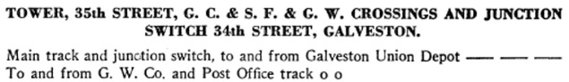
under a title that begins "TOWER, 35th STREET..." T&NO
associated Tower A with 35th St. and
there was also a junction switch associated with 34th St. But neither of
these streets was near the tower nor intersected Mechanic St., faring no
better than 36th St. as a naming rationale. Yet, this must be Tower A as
there were no other manned towers in the area (to hear the whistle
codes!) and the codes for T&NO trains to reach their main track (three
long blasts) or the Post Office track (two short blasts) is the same as for the "Thirty-Sixth Street Interlocker".
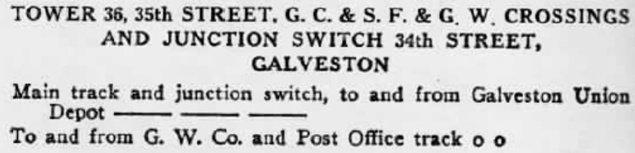
Left, Third: This 1951 T&NO ETT lists the same whistle
codes, but uses the confusing title "TOWER 36, 35th STREET...". This
appears to be an attempt to combine the 36th St. reference used by
Santa Fe with the 35th St. reference that T&NO had been using.
Unfortunately, it conveys the erroneous message of referring to "Tower
36" located in Bryan.
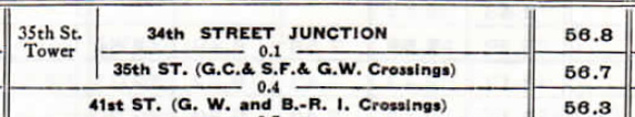
Left, Fourth: Elsewhere in the
1951 ETT, T&NO associates "35th St. Tower" with
the mileposts for the 34th St. junction and the 35th St. crossings.
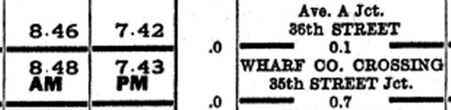
Left, Bottom:
In 1939, Santa Fe referenced the Tower A junction as "Ave. A Jct., 36th
STREET" apparently confusing Ave. A with Tower A. Mechanic St. was
platted as Avenue C, not Avenue A, which was two blocks from the tower, more than 200 yards
away at the closest point. Another junction 0.1
miles closer to Union Station was referenced as "WHARF CO. CROSSING, 35th
STREET Jct." Elsewhere in the 1939 ETT, Santa Fe confirms that these two
crossings are "protected by interlocking plant", but it does not name
the tower.
By the end of the 1990s, all of these railroads
had been consolidated into two large systems: Union Pacific (GH&H and
T&NO) and Burlington Northern Santa Fe (GC&SF and B-RI.) |
 |
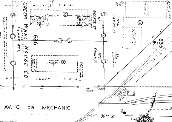
Far Left: The
1912 Sanborn Fire Insurance Map of Galveston shows the location of Tower
A where 36th St. was projected to intersect Mechanic St. (Avenue C). The
map shows that the angled building in the photos adjacent to the tower
was already in place. This building would eventually become the Farmer's
Marine and Copper Works building which has since been converted to a
large covered parking facility targeting visitors taking cruise ships
out of Galveston.
Near Left: Magnification of the map reveals a two-story "Switch Tower" with a
sizable roof overhang. |
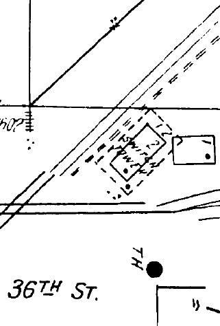
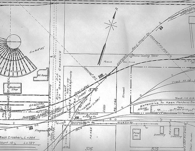
Right: This portion of a
larger "Station Map - Track and
Structures" drawing (June 30, 1918, revised Oct 1, 1933) from the GH&H Office of
Resident Engineer shows the location of Tower A ("Interlocking Tower", above and
slightly to the right of the center of the image).
Again, the
non-existent 36th
St. (unlabeled and marked as "Closed") appears to intersect Mechanic St., running horizontally beside the tower,
labeled only with "Public Gr. Xing". The Santa Fe
roundhouse appears along the left edge of the map. (courtesy Don Harper, Galveston Railroad Museum) |
 |
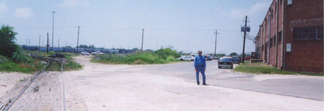
Above Left: This view is looking
southwest with former operator Frank Perez standing near the site of Tower A. The
Farmer's Marine and Copper Works building is at right. The original interchange track ran
behind Frank next to the angled wall of the building. The current UP interchange track to
the Galveston
wharves curves to the left. The
former
GC&SF yard track ran straight ahead and is partly torn up; a pile
of old ties is barely visible sitting atop the rails beyond the switch. Covered hoppers
seen in the distance are in the UP (ex-GH&H) yard. (Don Harper photo, 2001)
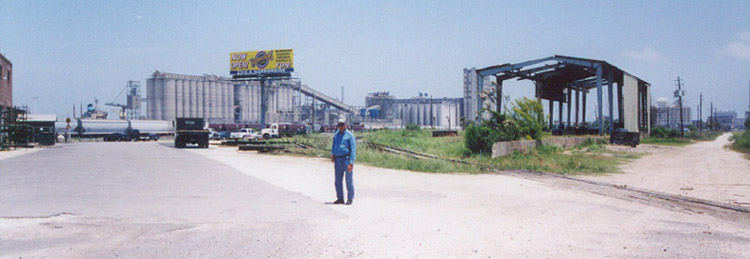
Above Right: The
view is to the northeast and the Galveston wharves grain elevators are in the
background (Elevator B to the left, the decommissioned Elevator A to the right). The low concrete wall across the tracks was
formerly part of a large cotton warehouse. Union Depot, now
the Galveston Railroad
Museum, can be seen in the distance to the right of the warehouse. (Don Harper
photo, 2001)
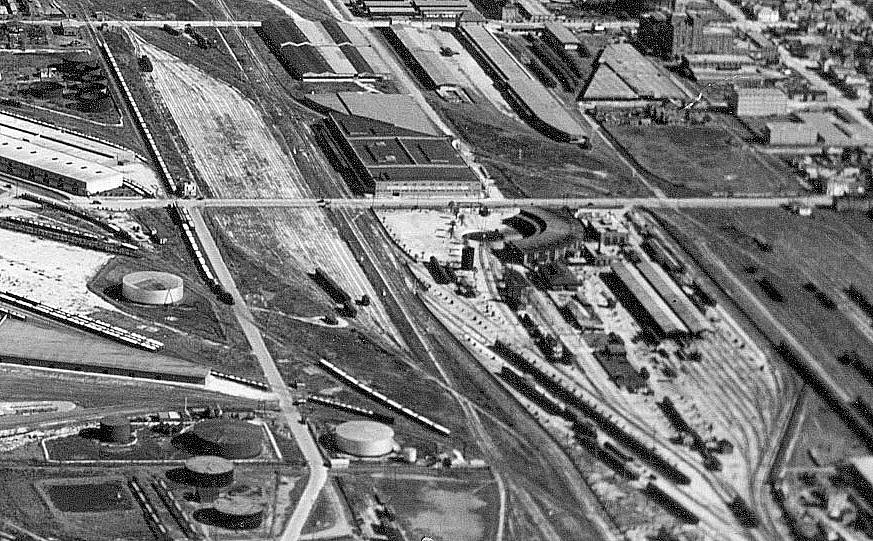
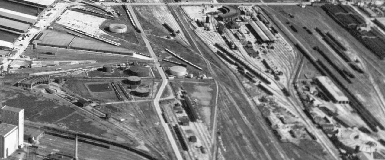
Above Left: Having studied the
historic maps above, can you spot the interlocking tower in this image, which is
cropped and magnified from a single large aerial photo of the east end of
Galveston Island? The
Santa Fe roundhouse is near the center. Above
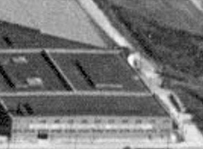
Right: The tower is adjacent to the far right corner along the slanted wall of the large building above and to the left of the
roundhouse. The proximity of the building restricted the tower operator's
visibility and contributed to the need for the large number of whistle codes used by engineers to
request switching alignments. (image courtesy of Don Harper)
Below: Don points out that all
three Galveston roundhouses are visible in the master scanned image. In this
snippet taken from the larger image, the Santa Fe roundhouse is at the top edge,
just right of center, the GH&H roundhouse is in the lower right corner, facing
the opposite direction as the Santa Fe roundhouse, and the T&NO roundhouse is
along the middle of the left edge of the image. What a great shot!
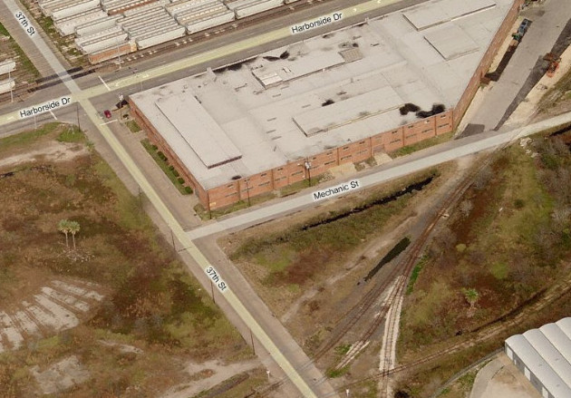
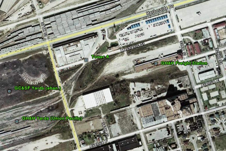
Below Left: This "bird's eye
view" image of the Tower A vicinity c.2008 shows remnants of the Santa Fe
roundhouse at far left. Below Right:
It's apparent from this satellite image that 36th St. aligns with the tower,
but no evidence has been uncovered that it ever extended to the vicinity of the
tower.

Last Revised: 12/28/2023 JGK - Contact the Texas
Interlocking Towers Website.