Texas Railroad History - Towers 28 and 42 - Texarkana
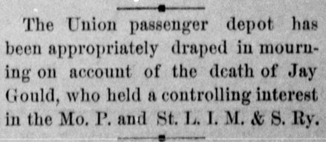
Crossings of the St. Louis
Southwestern, the Texas & Pacific, and the Texarkana & Fort Smith railroads
 |
Left:
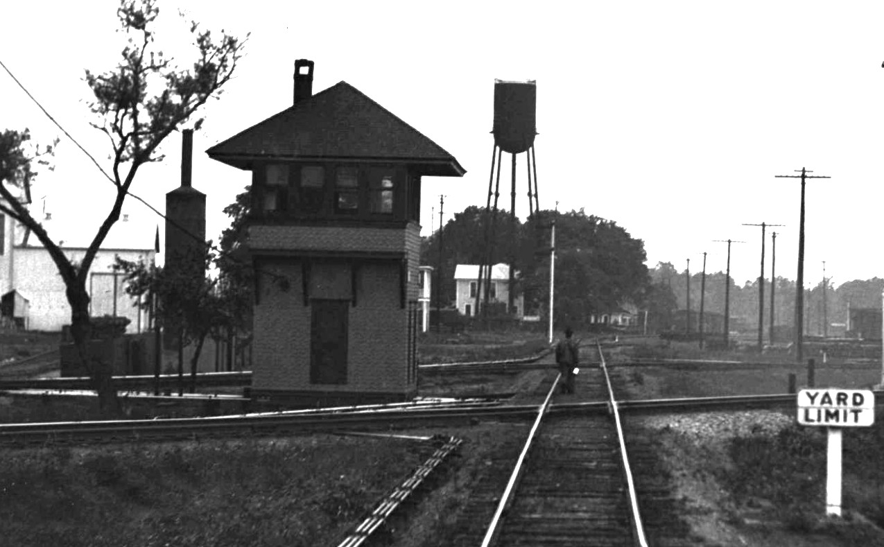
This image comes from a larger photo taken by railroad executive
John W. Barriger III from the rear platform of his business car in the
1930s. Barriger's
train was moving east through Texarkana on St.
Louis Southwestern ("Cotton Belt") tracks. His camera is
pointed generally west, but he turned slightly south to photograph Tower
42 while facing its northeast corner. Barriger's car has just passed over tracks of
the Kansas City Southern Railway visible running north / south on the opposite
(west) side of the tower. Tower 42 also managed crossings of the Texas &
Pacific Railway which Barriger's train would be passing over
in a few moments
if it had stayed on the Cotton Belt main track to the left. Instead,
his train has switched onto the passenger lead for Union Station where
he will soon arrive. (photo, John W. Barriger
III National Railroad Library)
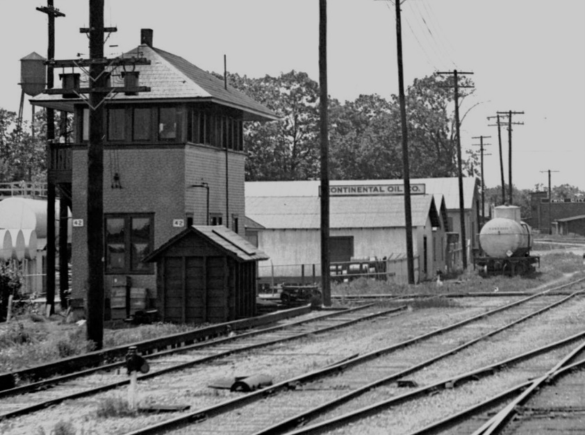
Below: On a different trip through Texarkana in
the 1930s, Barriger is facing north from his business car on a soutbound
Kansas City Southern train, passing through the yard of the
International Creosoting & Construction Company. As his train
completed its crossing of the
second of two Texas & Pacific tracks -- one on each side of Tower 28
-- Barriger snapped this photo of the tower, capturing with it a
man holding a lantern standing on the tracks between the two diamonds.
The photo has been brightened; Barriger's original is much darker,
having been taken at dusk. Barriger's train continued south
overnight to Shreveport
and DeQuincy, Louisiana, eventually passing Tower 31 as it neared
Beaumont the next morning. (photo,
John W Barriger III National Railroad Library) |
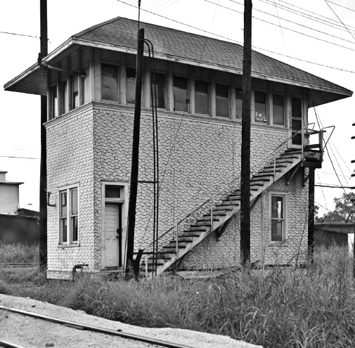
Below: southwest
corner of Tower 42 with KCS tracks in the fore-ground (Daniel Hardy,
August, 1980; Texas Historical Commission)
 |
 |
Long before the railroads, a trail passed through the
Texarkana area to move people and goods between the Mississippi River and the
desert southwest. The term Texarkana had been applied to settlements in
this region for years, well before the
town was formally established in December, 1873. The name clearly derives from a combination of the states it
stradles, Texas and Arkansas, and another nearby, Louisiana, but precisely who
created the name and when
remains in dispute.
The impetus for the first railroad at Texarkana began
with the idea of building a railroad across
Texas to be part of a projected southern transcontinental line. This was prior to the
Civil War, years before the first Transcontiental Railroad was built, a period
when the Legislature somewhat freely granted state charters to railroads
promising to build across Texas. There were two competing concepts. One
envisioned tracks diagonally across the state from the Arkansas border to
El Paso. In the opposite direction, tracks would
extend diagonally across Arkansas and Missouri to reach St. Louis, expected to
become the major rail gateway between the east coast and the western U.S. The
other concept was to build rails connecting Atlanta, Vicksburg and Shreveport,
more or less a straight line, with Marshall, and then continue across the state
to El Paso.
Two Texas railroad charters issued during this time led to the eventual
construction
of tracks at Texarkana. One was granted to the Vicksburg & El Paso Railroad
Co. which the charter law also called the Texas Western Railroad.
This charter changed hands but was eventually reacquired by the original
promoters who then asked the Legislature to change its name to Southern
Pacific Railroad, unrelated to the famous Southern Pacific
that evolved in California in a similar timeframe. The name change was granted
in 1856 by the Legislature, overriding a veto by Texas Governor Elisha Pease. Work began at Swanson's
Landing, a riverport at the south end of Caddo Lake (near the present day town
of Karnak) connected by waterways to
New Orleans. This enabled rails, locomotives and other materials to be shipped to Texas by
barge. A track was completed southwest to Marshall by the end of 1859, enabling
residents there to take the train 27 miles to Caddo Lake for a day of recreation
on the water. Tracks were also completed to Jonesville in the direction of
Shreveport, intending to connect with a Louisiana railroad at the state line.
During the Civil War, the rails between Swanson's Landing and Jonesville were
taken up to be used to advance a direct rail line between Marshall and
Shreveport.
The other charter was granted to the
Memphis, El Paso & Pacific which was to build west from Texarkana
through the counties bordering the Red River. It was planned to cross the Brazos
River at Fort Belknap (85 miles northwest of Fort Worth)
before turning southwest to El Paso. A total of
65 miles of track was laid west from Texarkana prior to the Civil War.
Additional grading was done in the vicinity of
Jefferson, a major riverport with access to New Orleans. The validity of the Memphis, El Paso & Pacific
charter came into question in the immediate
aftermath of the Civil War stemming from a disputed land grant provision. The
Legislature solved the problem by granting a new charter in July, 1870 under the name Southern
Transcontinental Railroad Co. The new company would be allowed to acquire the assets
of the Memphis, El Paso & Pacific and the Southern Pacific.
On March 3, 1871, Congress granted a Federal railroad charter to the
Texas Pacific Railroad (renamed Texas &
Pacific Railway -- "T&P" -- a year later) for the purpose of building a transcontinental
rail line from Marshall to San Diego, California. The Texas Legislature authorized the T&P to
acquire the Southern Pacific and the Southern Transcontinental Railroad Co.,
which happened on
March 21 and March 30, respectively, 1872. A year later, the T&P acquired the assets of the Memphis, El Paso & Pacific
out of foreclosure.
By the end of 1873, new construction plus the
acquired assets resulted in the T&P having three main track segments: 1) from the Louisiana border through Marshall and Longview to
Dallas;
2) from Marshall north through Jefferson to Texarkana; and 3) fifty-four miles
of track from
Sherman east to Brookston in the direction of Texarkana.
Building eastward from Sherman was deemed the better approach because materials
could be shipped there from the Port of Galveston using the Houston & Texas Central (H&TC) rail
line out of Houston that had reached Sherman in 1872. The T&P
completed the tracks from Brookston east to
Texarkana in 1876, and that same year, it extended its line westward
from Dallas to Fort Worth.
The T&P was
following the two-track approach the Legislature had envisioned, with a southern
line from Shreveport through Marshall to Dallas, and a northern line running west from Texarkana to
Sherman and beyond. The plan west of Sherman was undetermined; the T&P had
acquired rights and physical assets of the Memphis, El Paso & Pacific
but not its charter, and thus the T&P was not bound by the provision to build to
Fort Belknap. In the east, the two lines were linked by
the tracks between Marshall and Texarkana. In the west, Fort Worth became the
target connecting point for the two lines. From there, a single line west to El
Paso would be built.
 |
At Texarkana, the T&P laid out the Texas side of town in 1873 while
awaiting arrival of the Cairo and Fulton (C&F) Railroad, a company
chartered in Arkansas. The C&F would provide a direct route to St. Louis
through its connection with the St. Louis & Iron Mountain Railway at the
Arkansas / Missouri border. By January, 1873, the C&F had built from the
border to the north side of the Arkansas River at Little Rock. While a
bridge over the river was constructed, the C&F continued building toward
Texarkana. The bridge opened in December, 1873, and a month later, C&F
rails reached
Texarkana, connecting with the T&P and creating a new route for rail service
between Dallas and St. Louis. In May, 1874, the
C&F and the St. Louis & Iron Mountain were reorganized into the St.
Louis, Iron Mountain & Southern (SLIM&S) Railway.
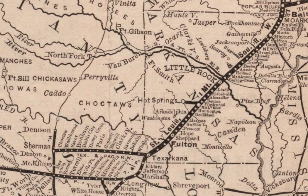
Left: The Cobb Digital
Map Collection at the Texas General Land Office contains an 1877 map of
the SLIM&S from which this excerpt is taken. The map was produced by the
railroad to show its routes and connections from St. Louis through
Poplar Bluff, continuing across Arkansas into Texas. The T&P had yet to
build west of Fort Worth, so the track in that direction is marked with
a different line style indicating future construction. Two International
& Great Northern lines are also in bold -- southwest from Longview (to
Palestine) and from Mineola to Troup. The north / south line through
Dallas and Sherman to Denison is the H&TC.
At Denison, the H&TC's connection to the Missouri, Kansas & Texas
("Katy") Railway provided routes through Indian Territory (Oklahoma) to Kansas City and
St. Louis, although the latter route was longer than the one through Texarkana. |
While the C&F was planning its path across
Arkansas, the International Railroad was chartered in Texas in August, 1870 by
investors involved with the C&F. The idea was for the International to become a Texas extension through
Austin and San Antonio
to the Rio Grande River. The goal was to create a major route for
international trade between St. Louis and Mexico via Texarkana. The
International's construction commenced at two locations, Hearne and Longview, in 1871.
Longview was chosen because it was already apparent that the newly chartered T&P
would soon have a line between Longview and Texarkana via Marshall. By February,
1873, the International had completed tracks from Longview through
Palestine to Hearne.
In this same timeframe, the
Houston & Great Northern was
building north from Houston to
Palestine. Anticipating the connection at Palestine, the International's
management saw value in a combined railroad that would eventually serve Houston,
Austin, San Antonio and Laredo. An agreement was reached in December,
1872, and the two railroads began operating under a combined management structure
based in Houston
while awaiting permission to merge. In March, 1875, the Legislature authorized the new
railroad, the International & Great Northern (I&GN). Soon it would be
Texas' largest.
By the 1870s, east coast rail
baron Jay Gould had begun to shift his attention to the west and southwest,
planning a major presence in Texas. It offered ports on the Gulf through
which commodities from Midwest and Plains states could be exported, plus the potential for
trade with Mexico. The I&GN became his target, already moving freight and
passengers between St. Louis and Houston via Texarkana. In 1879, Gould
acquired control of the Missouri Pacific (MP) Railroad based in St.
Louis. For his southwest expansion, railroads would be merged by lease
or acquisition into MP. In December, 1879, the selection of Gould as
President of the Katy was accomplished by his loyalists who had
infiltrated Katy management over several years at Gould's behest. The
plan had been hatched because the Katy's diluted stock
prevented Gould from acquiring controlling interest, the usual
path to a takeover. Gould soon leased
the Katy to MP.
To attack the I&GN, Gould also needed the
T&P. It offered the potential of a southern transcontinental route, but
more important to Gould, it provided a critical link for the I&GN's
access to St. Louis via Longview and Texarkana. The T&P had become
stalled at Fort Worth, unable to finance construction to El Paso.
Sensing opportunity, Gould offered to build the T&P west of Fort Worth in
exchange for $40,000 in T&P stocks and bonds for each mile
completed. A deal was struck and track-laying began in
April, 1880. Gould was effectively in command of the T&P, and by
April, 1881, he owned controlling interest. He proceeded to lease the
T&P to MP.
Gould also wanted the SLIM&S in his pocket before
attempting to take on the I&GN. His plan was simple -- route the T&P's
St. Louis traffic via Oklahoma on the Katy rather than the SLIM&S
through Texarkana. Gould also bought the terminal railroad
at St. Louis that facilitated the SLIM&S' path into the city.
Constrained at both ends with diminished traffic, SLIM&S ownership
capitulated in December, 1880 and sold a large block of stock to Gould,
giving him about 30% of the company. They did not further resist his
control and the SLIM&S was leased to MP. The I&GN realized its fate and sold out to Gould
in June, 1881 in an exchange for Katy stock. Gould finessed who or what actually owned the I&GN,
and he tried to cast doubt on that idea that it was the Katy by leasing
the I&GN to the Katy.
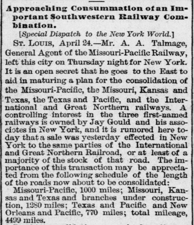
Right: A full month before
his acquisition of the I&GN, the
Galveston Daily News of April 30,
1881 reported speculation by New York papers that discussions were being
held to consolidate Gould's MP and Texas railroads, including the I&GN.
The article was incorrect regarding Gould's ownership of the Katy; he
was President, but he lacked financial control. |
 |
In the high stakes railroading of the Gould era, there
were always threats, and the biggest for Gould was the Texas & St. Louis (T&SL)
narrow gauge. It had originally been chartered as
the Tyler Tap Railroad in 1871 to bring rail service to
Tyler by "tapping" the
T&P at Big Sandy. This was finally accomplished in
1877. The name was changed to the T&SL in 1879 when a 107-mile segment was built
from Big Sandy to Texarkana. By 1884, construction had been completed across
Arkansas and Missouri to Bird's Point on
the Mississippi River. There, barges moved railcars across the river
to Cairo, Illinois. The expansion
overextended the T&SL's finances and it went into into receivership in
January, 1884.
As the corporate reorganization proceeded slowly, the
bankruptcy judge grew impatient, forcing the T&SL to be sold rather than
merely reorganized. Selling required dividing it into two properties,
the Texas lines and the Arkansas - Missouri lines, for compliance with
Texas' railroad ownership laws. The Receiver, Samuel Fordyce, cautioned
the judge that operational issues would risk profitability, but the
advice was ignored. The sale was executed to a bondholders' committee in early 1886. In
February, the committee deeded the Texas assets to the St.
Louis, Arkansas & Texas (SLA&T) Railway in Texas, a new company created for
the purpose of restarting the Texas portion of the railroad. In April, the
Arkansas and Missouri assets were similarly deeded to the St. Louis, Arkansas
& Texas Railway in Arkansas and Missouri with Sam Fordyce as President of both companies.
The combined SLA&T consisted of a single main line between Bird's Point and
Gatesville, southwest of Waco. By 1887, Fordyce had converted it to standard gauge
and was developing a plan to compete with Gould on Midwest
traffic through Fort Worth. To do so, Fordyce built a branch from
Mount Pleasant to Commerce, 57 miles west. There, the line split into two branches: one
to Sherman and one to Fort Worth, completed in
1888.
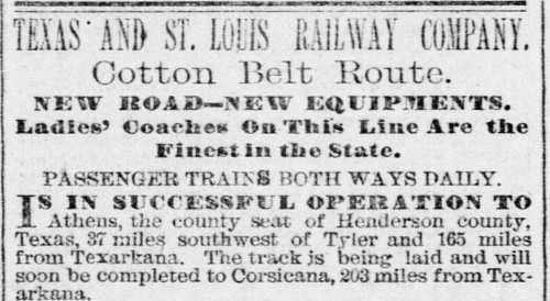 |
Left: This
January 21, 1881 T&SL advertisement in the
Galveston Daily News
introduced "Cotton Belt Route" as a marketing tag for the
T&SL. The nickname stuck for the next 110 years.
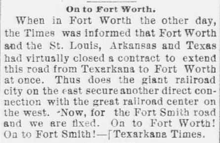
Right:
The Fort Worth Daily Gazette of June 4,
1887 quoted a recent news item from the
Texarkana Times announcing a contract to build an extension of
the SLA&T west to Fort Worth. The construction would be completed in
less than a year. |
 |
Increased competition from the Cotton Belt may not have
been Gould's
biggest problem; he had several others. James S. "Jim" Hogg was elected Texas
Attorney General in 1886 by campaigning on a promise to go after the railroads
for various infractions. Among others, both the Katy and I&GN became targets
of lawsuits alleging price-fixing, poor service
and poor infrastructure, each a violation of their state railroad charters. Hogg
also sued the Katy claiming that its 1881 purchase of the East Line & Red River (EL&RR)
Railroad (from Jefferson to
Greenville, extended to McKinney by Gould) was
unlawful because the Katy was an out-of-state railroad, headquartered in Kansas. Gould was
already on thin ice with Katy stockholders who had come to understand that the
lease to MP was siphoning Katy profits for Gould's benefit. Despite his best
efforts, the stockholders eventually succeeded in summoning a quorum in May, 1888
where they fired Gould for malfeasance due to the MP lease. New
Katy management promptly sought bankruptcy protection and asked the court to
dissolve the lease.
The Texas Supreme Court ruled that an 1870 Texas law
authorizing the Katy to connect with the H&TC in Texas over the (planned) Red River bridge
was not a Texas railroad charter, rendering
unlawful the Katy's ownership of the I&GN, the EL&RR, and all of its construction under
the MP lease. It was left to the Legislature to sort out the mess by issuing a new
charter to dictate which rail lines the Katy would be allowed to own. Hogg was
adamantly opposed to having Texas' largest railroad owned by an out-of-state
company, and he had significant influence in the matter because he had been
elected Governor in 1890 (on a platform advocating creation of a Railroad
Commission of Texas, "RCT", which was accomplished in 1891.) The law
Hogg signed in October, 1891 granted a Texas railroad charter to a new wholly-owned subsidiary
of the Katy to be
headquartered at Denison that would own virtually all of the lines the Katy had
built or acquired in Texas except the I&GN and the EL&RR.
The Katy had no choice but to sell the I&GN to Gould, who continued as President of both the
I&GN and the T&P. The EL&RR remained in bankruptcy pending
organization of a new ownership group.
As Gould
began navigating the legal and financial storm being stirred up by Hogg,
vigorous
competition by the Cotton Belt on its new branch lines to Fort Worth and Sherman had impacted revenue
to both parties. Gould had discerned that the Cotton
Belt was in a financial squeeze, so in 1888 he negotiated a secret
arrangement with Fordyce to cooperate on traffic through Texarkana.
Gould then began to accumulate financial leverage over the Cotton Belt through loans
and stock purchases, positioning him to guide its inevitable reorganization. As
Fordyce had predicted to the bankruptcy judge, the Cotton Belt was unable to
stay profitable, and both SLA&T companies went into receivership in May, 1889.
Fordyce was again named Receiver. After 18 months of reorganization, yet another
new company was chartered. Gould preferred to call it simply the Cotton Belt
Railroad, but St. Louis Southwestern (SSW) Railway was chosen
instead. It was incorporated as two legal entities -- one in Texas and
one in Missouri -- in January, 1891, with Fordyce again named President.
Jay Gould's son Edwin was named Vice President, an indication of the
sizable ownership position of the Gould family.
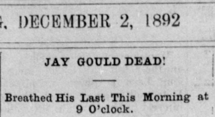 |
Jay Gould's death in New York City in
December, 1892 was big news all over the U.S. and certainly in
Texarkana. His elder son George took over the family business and
replaced Jay as Preisdent of the I&GN and the T&P. George's younger brother Edwin remained Vice President of the Cotton
Belt.
Texarkana Daily Democrat
December 2 (left) and
3 (right), 1892. |
 |
In 1885, the newly chartered Texarkana & Northern
Railroad built ten miles of track north from Texarkana to the Red River for
logging purposes. In 1889, the name was changed to the Texarkana & Fort Smith
(T&FS) Railway with plans to extend the line north to Fort Smith. With only limited
northward construction accomplished, the T&FS was acquired in 1892 by the Kansas
City, Pittsburg and Gulf (KCP&G) Railroad to become part of a main line between
Kansas City and the Gulf. The KCP&G was the brainchild of Arthur Stilwell, a New
Yorker who had settled in Kansas City in 1886. The KCP&G planned to build due south from Kansas City through Pittsburg (Kansas),
Fort Smith and
Texarkana to reach an unspecified deep water port on the Gulf (which became the eponymous town of
Port Arthur.) T&FS
construction south from Texarkana was initiated under an amended charter in
1893, and portions of it were built in Louisiana under a different charter. The main line from Kansas City through
Fort Smith, Texarkana, Shreveport, DeQuincy and Beaumont
was completed to Port Arthur in late 1897.
In 1899, Stilwell
lost financial control of the KCP&G; it went into receivership and he was booted
off the management team. The
court appointed Sam Fordyce to be Receiver for the KCP&G and he resigned as President
of the Cotton Belt (replaced by Edwin Gould.) When the receivership terminated,
the Kansas City Southern (KCS) Railway was chartered in Missouri in 1900 to
acquire KCP&G assets out of foreclosure. Fordyce was named KCS President and the
T&FS became KCS' Texas-based subsidiary that owned the tracks in Texas. In 1933,
KCS petitioned the Interstate Commerce Commission (ICC) for permission to
dissolve the T&FS and merge its assets directly into KCS. The State of Texas
opposed the petition because KCS was not headquartered in Texas as required by
state law. The case went to the U.S. Supreme Court in 1934 which
ruled that
the Transportation Act of 1920 gave the ICC authority to override protectionist
railroad laws and regulations enacted by states. KCS waited until 1943 to exercise its
newly-granted
prerogative of dissolving the T&FS.
The last railroad to build tracks in Texarkana was the Texarkana
and Shreveport Railroad. Its initial construction was southeast out of
Texarkana to a sawmill at Fouke, Arkansas c.1894, a distance of about fifteen
miles. It was acquired by the Texarkana, Shreveport & Natchez (TS&N) Railway
in 1899. The TS&N extended the tracks south, eventually passing
through the Louisiana towns of Ida, Hosston and Gilliam on its way into Shreveport. On February 9, 1901, the TS&N
was sold to the T&P. After decades of operation, the segment between
Texarkana and Hosston was abandoned c.1966. Hosston retained tracks because it
was the site of a refinery served by the T&P from Shreveport. The refinery
closed in 1981 and the tracks between Hosston and Shreveport were abandoned soon
thereafter.
 |
Left: The date
for this map was chosen so that KCS' acquisition of the former EL&RR
tracks from Jefferson through Pittsburg to
McKinney could be included. After the
EL&RR receivership was resolved in 1893, it went through a series of owners
and name changes. In 1900, the line was extended from Jefferson to
Waskom, connecting there with tracks to Shreveport. In 1899, the Legislature
made a deal with the Katy, allowing it to reacquire the tracks between
McKinney and Waskom in exchange for building tracks from San Marcos
to San Antonio. This was accomplished in 1901 and the line was part of
the Katy for the next two decades. When the Katy
emerged from receivership in 1923, the line was sold. It was owned by the Louisiana & Arkansas Railway before coming under KCS ownership in
1939. In 1956, KCS built a new main line to Shreveport from
Karnak and abandoned the tracks from Karnak to Waskom. KCS continues to
operate these tracks; in March, 2023, KCS merged with
Canadian Pacific, forming CPKC.
MP's former SLIM&S route
ran northeast out of Texarkana to Little Rock and St. Louis. The Cotton
Belt route to St. Louis went fifty miles east from Texarkana before
turning northeast. It passed through Pine Bluff, forty miles southeast of Little Rock, where a major yard and shops were built. Farther north, a
branch to Memphis became effectively a second main line.
Southwest of Big Sandy, the Cotton Belt
went to
Tyler where it crossed I&GN tracks that ran between Troup and Mineola.
Troup was on the I&GN main line southwest of Longview.
Beyond Tyler, the Cotton Belt continued to Waco and Gatesville with a
branch from Corsicana to Hillsboro. A major Cotton Belt branch
out of Mt.
Pleasant went 57 miles west to Commerce and split into separate branches
to Sherman and Fort Worth. The Fort Worth branch also had a lengthy spur
into downtown Dallas.
The T&P had three lines out
of Texarkana. The line to the west went to
Paris, Sherman and Whitesboro, where it
turned southwest to Fort Worth. The T&P's south line out of Texarkana
went to Marshall and turned west through Longview and east to
Shreveport. The former TS&N route went southeast out of Texarkana to
Fouke and turned south to Hosston and Shreveport. It was fully abandoned
by 1981. The T&P line west of New Boston has also been abandoned. Except
for the KCS tracks to Waskom noted above, all other lines on this map
remain active. |
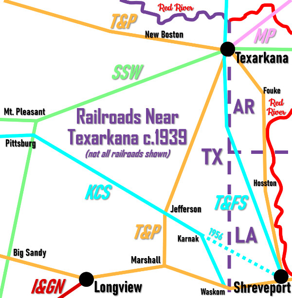
The railroads established two interlocking towers in
Texarkana. The first of these was Tower 28, commissioned by RCT on October 20,
1903 hosting a 20-function mechanical plant built by Union Switch & Signal Co.
Tower 28 controlled the crossing of the T&FS and the T&P about two and a half
miles south of downtown Texarkana on property of the International Creosoting &
Construction Co., a railroad tie manufacturing facility. At Tower 28, the T&FS
line from Texarkana to Shreveport crossed two parallel T&P tracks. One was
the primary yard track; the other was the main line between Texarkana and Marshall.

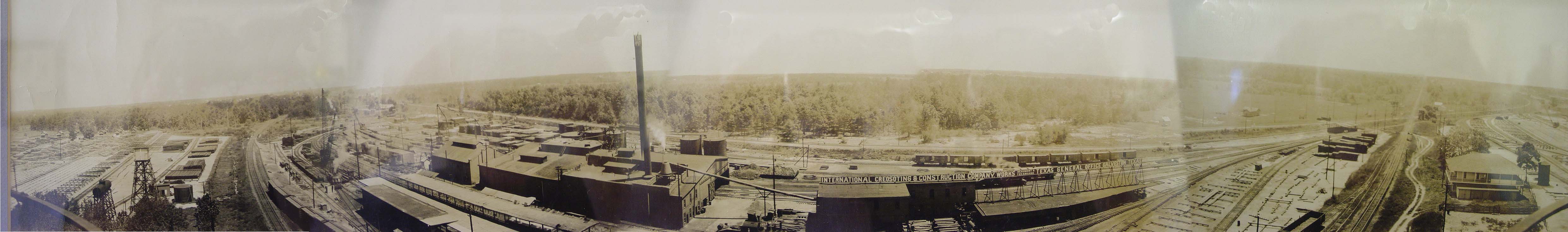
Above: Tower 28 is visible sitting beside the
intersection of rail lines on the right side of this undated photo. The
panorama was probably taken from the top of the water tower visible in
Barriger's photo at top of page. The creosoting facility eventually became owned by the Kerr-McGee
Corporation. It was at one time (and might
still be) listed as a Superfund cleanup
site due to decades of improper storage and disposal of creosoting chemicals.
Click the image twice for the fullly enlarged version of the photo.
(Kerr-McGee Co. photo, Myron Malone collection)
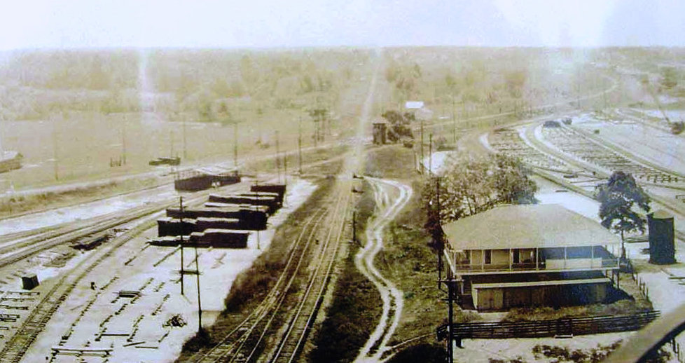 |
Left: The right side of the enlarged version of the
above photo looks south down the KCS tracks that ran along the east side
of Tower 28. The tower is visible between two T&P tracks --
the main line on the south (distant) side of the tower and a yard track along the
north side of the tower. North of the tower, the yard track branched
into multiple tracks serving different parts of the factory. South of
the tower, the yard track accessed multiple storage sidings.
The
two-story building in the foreground looks very much like a residence,
and there could also have been guest quaters and office space. Geneology
records list a young woman, Geneva Stuart, who is reported to have lived
on the grounds of the facility for three years beginning shortly after her
marriage in 1910. |
Left:
This simulated 3-D view produced by Google Maps from recent satellite imagery is
similar to the photo above. It shows the CPKC tracks going south across the former T&P
line, now owned by Union Pacific (UP). To the left of the crossing, the tan
cabin with the darker roof housed the original automatic interlocking, but it
has likely been replaced by the newer gray cabinet sitting
beside it.
The tie plant is now dismantled but it is unclear whether the
Superfund mitigation has been completed.
 |
Tower 28 is visible in 1935 historic aerial
imagery, but not in 1948 imagery. A March 26, 1944 T&P Employee
Timetable lists the crossing with an automatic interlocker. The
disposition and date of Tower 28's demise is undetermined. Myron Malone
took these photos of the crossing c.2005.
Left:
Looking south on the KCS main line, the concrete
bunker to the left is the automatic interlocker cabin that replaced
Tower 28's plant. The interlocker's override controls are mounted in the
smaller box near the tracks. The old lead into the tie plant is in the
foreground and the UP main line is behind the cabin. The Highway 151
overpass is barely visible in the distance.
Right: The site of
Tower 28 is where the short sections of rail lay next to the weeds, but
there is no evidence of its foundation. |
 |
A comprehensive table of active interlockers published
by RCT at the end of 1903 (and annually thereafter through the end of 1930)
listed Tower 28's location as Sulphur.
This was probably a reference to the community of Sulphur, a small station on
the T&P located approximately five miles south of Tower 28, but the reason for
this geographic misidentification is unknown. The location persisted as
Sulphur until the table dated October 31, 1906 changed the location to
South of Texarkana. This table included traffic information showing Tower
28 had experienced 27 average daily movements past the tower during the twelve
months ending June 30, 1906. The table published October 31, 1916 changed Tower
28's function count to 24. This table was also the first to identify the
railroad responsible for operating each tower; for Tower 28, it was the T&P. Ten
years later, the table dated December 31, 1926 revised the location to
Texarkana, 2 miles west. This was probably a reference to the T&P timetable
for which "west" on this line was geographically south to Marshall and then west
to El Paso. A year later, the table again changed the location, this time to
West of Texarkana. This location persisted through the final table
dated December 30, 1930, still showing a total of 24 functions and the T&P
with operational responsibility. For a building that never moved, Tower 28 had
a lot of locations!
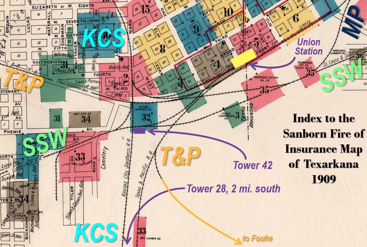
Above:
This index to the 1909 Sanborn Fire Insurance map set of Texarkana has been
annotated to show the location of the interlocking towers and to highlight the
complicated topology of the railroads through the city. Although the map
identifies KCS as the owner of the main north / south line, it technically
belonged to the T&FS in 1909. Texarkana Union Station (yellow
rectangle) was (and remains) located along Front St., straddling the state line.
Other than the T&P tracks to Fouke abandoned in the mid 1960s, all of these
tracks remain in service. The
T&P's northern line out of Texarkana is mostly abandoned, but the tracks are
still in use between Texarkana and New Boston to serve a nearby U.S. Army Depot
and a commercial lumber yard. The tracks west of New Boston were abandoned in
1996.
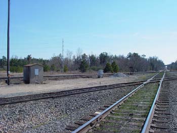
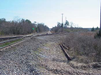
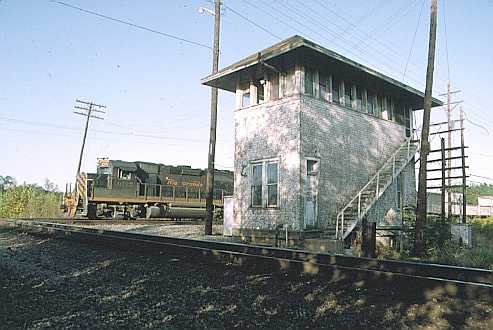
Tower 42 was located a little more than a half mile
southwest of Union Station. Though it sat adjacent to a crossing of the T&FS (KCS) and the Cotton Belt main lines,
it also handled the T&P's crossings with these railroads and was manned by
T&P personnel. RCT's
comprehensive interlocker table dated October 31, 1904 lists Tower 42 hosting an
electric interlocker built by Pneumatic Signal Co. (PSC) with 70 functions spread over
47 operational levers (among a total of 56 levers available.) The entry for
Tower 42 in RCT's table is different from all other entries because it has two asterisks, one
next to Texarkana in the "Location" column and one next to the date,
July 7, 1904, in the column titled "Operation authorized by
Commission". Though not specified directly in the table, these asterisks indicate
that RCT's authorization for Tower 42 to operate was only
temporary because the interlocking plant had failed inspection.
What
happened? It appears that PSC's design for the Tower 42 interlocking plant was
based on new technology that was still in development at the outset of the
project. The plant for Tower 42 may have been the first to employ this technology,
and the system encountered problems when
installed. Some of these problems were design mistakes in the interlocking plant and others were the result
of poor workmanship during installation. Wiring to signals and derails appears
to have become a critical
point of failure over relatively short periods of operation. T&P
had been given the
responsibility from RCT to erect the Tower 42 building and acquire the
interlocking plant, and it had contracted with PSC for a turnkey system,
including a requirement for PSC to operate the interlocker for the first sixty
days. After the failed inspection, RCT allowed work arounds and procedural
changes to be used so that the plant could operate to some extent until fixes
were made, but the results were mixed and the record-keeping was very poor.
Because the interlocking plant was operating on temporary authority from RCT and
eventually failed inspection twice, T&P refused to pay the $16,650 contracted
price to PSC.
PSC filed a lawsuit against T&P in a New York district
court in the summer of 1907 to collect the debt, claiming that T&P had
"accepted" the system because it was in use, albeit under temporary restricted
authority. Numerous fixes had failed to mitigate the problems, and worse, many
of them were improperly documented, or not documented at all. By the
summer of 1907, RCT had
ordered the interlocking plant condemned and replaced (going so far as to order
that not one piece of it could be salvaged; everything had to go.) There was
additional complexity to the litigation because in the middle of the Tower
42 project, PSC had merged with Taylor Signal Co. and Standard Railway Signal
Co. in 1904 to form General Railway Signal (GRS) Co.
A jury trial was held, and the jury
ruled for the Defendant, T&P. The verdict was appealed and there may
have been additional trials due to remands by appellate courts. It
appears that T&P ultimately won, although as late as January, 1911, the
case was still under appeal and had produced a
lengthy appellate transcript.
[Editor: If someone can wade through 616 pages of legal jargon,
please generate
a synopsis and I'll add it to this page!]
The transcript includes detailed testimony by RCT's engineer.
Right:
The December, 1908 issue of The Signal
Engineer reported that a new Union Switch & Signal Co. plant
for Tower 42 was to be installed by December 20. RCT's table dated
October 31, 1909 was the first to have no asterisks on Tower 42's entry. |
 |
After Jay Gould's death, the Gould family remained in
control of MP, I&GN and T&P. Jay's son George operated MP and the T&P
successfully for many years, but had less success running the I&GN. A reputation
for accidents, many of them attributed to poor track design on the new 1902 Houston
- Fort Worth line, caused the
I&GN to be under constant orders from RCT to correct problems and improve
service. It entered receivership in February, 1908, and in June, 1911, the Gould
family bought it out of bankruptcy and resumed control. The I&GN went back into
bankruptcy in 1914, and at that point, the Gould family connection to the I&GN
ended forever. It was not until July 28, 1922 that the I&GN emerged from
bankruptcy as a newly reorganized and independent company under the name
International - Great Northern Railroad (hence both I&GN and
I-GN are used as abbreviations.)
MP underwent a financial
reorganization in 1917 at which time the Gould era ended completely for both MP
and the T&P. The railroads had worked closely together since the early 1880s,
and in 1918, MP began to purchase T&P stock on the market with an eye toward
eventually acquiring a
controlling interest. In 1924, MP
tried to buy the newly independent I-GN as a means of reentering the Texas
market but the ICC refused to approve the sale. The purchase was restructured to
include additional railroads, and on January 1,
1925, MP was able to buy the I-GN and several others operating in Texas and
Louisiana. By 1930, MP owned
controlling interest in the T&P but it did not exercise executive control. In
1933, the Great Depression sent both MP and its I-GN subsidiary into
receivership. The receiverships ended in 1956, resulting in the
I-GN becoming fully integrated into the reorganized MP.
In 1976, MP
finally merged the T&P, having acquired most of T&P's stock by then. In 1982, MP was acquired by
UP but continued to operate as an independent subsidiary. In
1988, UP acquired the Katy and merged it into MP, recombining the railroads a
hundred years after MP's lease of the Katy had been broken by the Texas Supreme
Court. A few years later, UP acquired and merged Southern Pacific (SP), another
large western railroad that had operated the H&TC and many others in Texas. SP
had controlled the Cotton Belt since 1932, seven years after Edwin Gould had
retired as President. The Cotton Belt had continued as an independent
subsidiary until it was merged into SP in 1992. In the late 1990s, UP fully merged
SP and MP, and began operating solely under the UP name. Today, the routes
through Texarkana developed by MP, the T&P and the Cotton Belt are owned and
operated by UP.
 |
 |
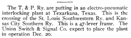
Far Left:
Sunshine illuminates the east
face of Tower 42.
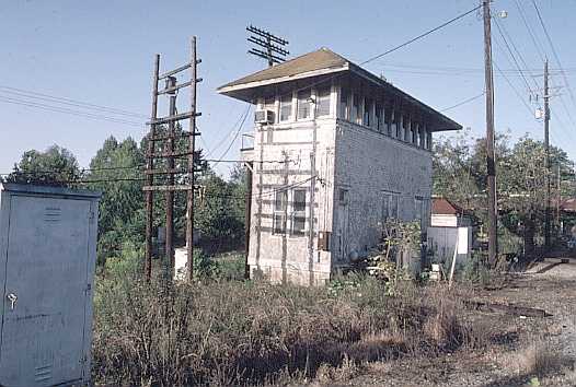
Left:
the south side of Tower 42, with KCS tracks to the left
both photos taken October 8, 1992
by Myron Malone. |
 |
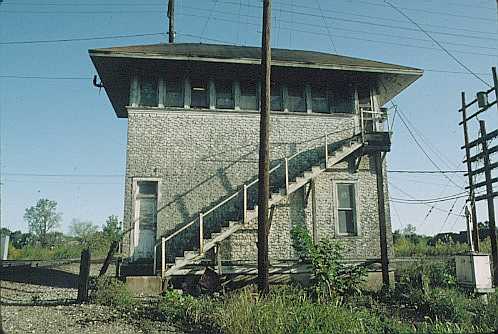
Left:
A Cotton
Belt intermodal train crosses the diamond and blocks the KCS main line adjacent to Tower 42. The train is
facing due west but by timetable, it is traveling south.
Right: A Denver and
Rio Grande Western Railroad locomotive unit leads a Tyler-bound
intermodal train past the tower on SP's former Cotton Belt tracks.
both photo taken by Myrone Malone on October 11, 1992 |
 |
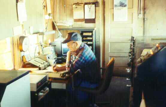
| Right:
This interior
photograph of Tower 42 was taken in 1988 by Paul Farfrak. Nothing much
would have changed by the time the tower was taken out of service in the
early 1990's. The levers and interlocking machine along the right edge
of the photo were removed from the tower by a local Texarkana historical
group just before the tower's demolition. |
 |
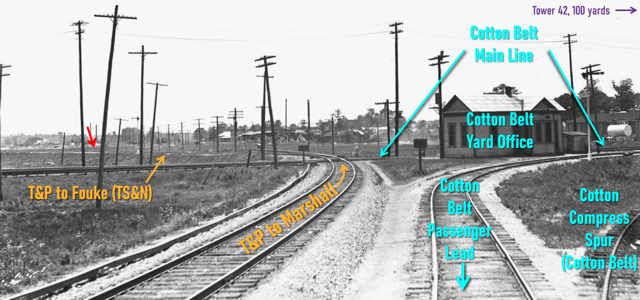
Above: This image taken by
John W. Barriger III has been annotated to mark the track topology.
Assuming it was taken several seconds after
Barriger's photo of Tower 42 at top of page (instead of perhaps a different trip)
Barriger's train has indeed taken the Cotton Belt passenger lead toward Union
Station as previously speculated. He is facing generally southwest from the rear
of his business car which moments before passed the north side of the Cotton
Belt Yard Office. The Cotton Belt main line is barely visible passing along the
far side of the office. To Barriger's left, the T&P main line curves to cross
the Cotton Belt and proceed south to Marshall, passing Tower 28 in about two
miles. Immediately beyond the diamond,
T&P's branch to Fouke departs the main track and proceeds southeast. This
track acted as the north lead of a wye track. The south lead (red arrow)
is barely visible having come off of the T&P main line about 500 yards farther
south. The two leads connect off the image to the left. (photo,
John W. Barriger III National Railroad Library, hat tip Tony Wilson)
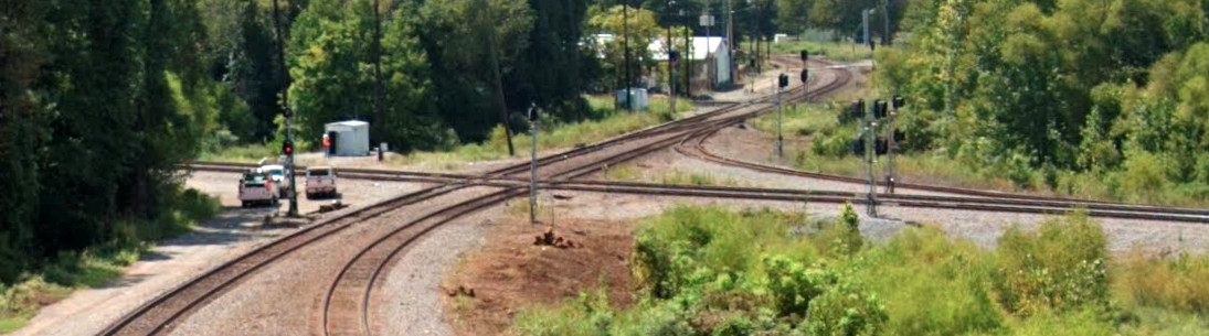
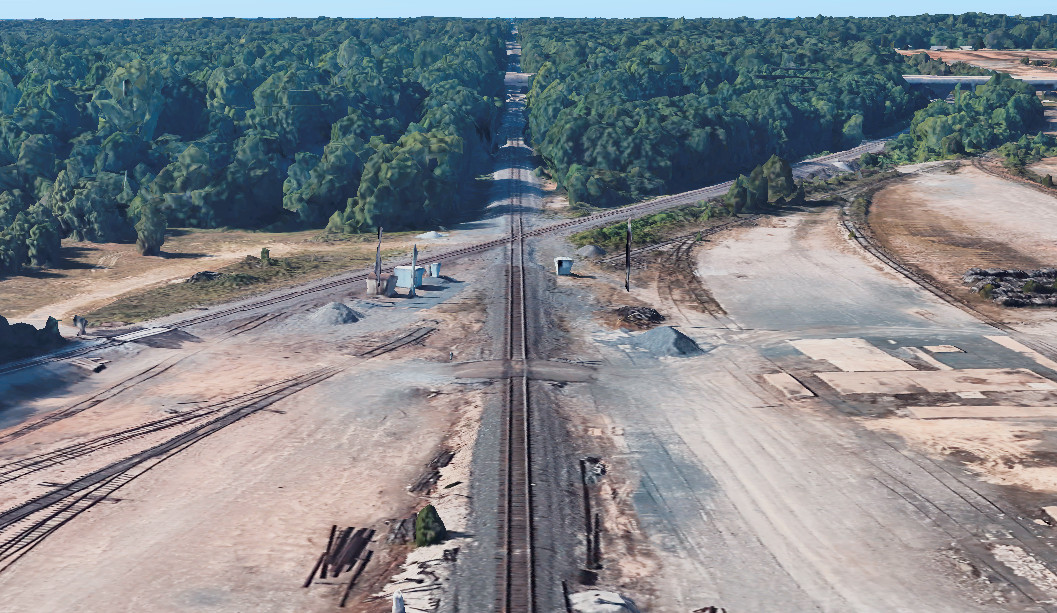
Above: This Google Street View
from August, 2022 was taken facing west toward Mt. Pleasant from the S. State
Line Ave. overpass above UP's former Cotton Belt route. At the quadruple diamond,
the two tracks cross UP's former T&P line to Marshall (left, south) and Union Station (right, north). The
ex-Cotton Belt lead to Union Station is visible as the northwest quadrant
connector. Beyond Union Station, UP's former MP yard is very active and the line
continues to Little Rock. Going east in the foreground, the tracks beneath the camera diverge because they form
the north (right) and south (left) track boundaries of UP's former Cotton Belt
yard, which has mostly been disassembled in favor of the ex-MP yard. Beyond the yard, the tracks
eventually merge into a single line on the east side of Texarkana and continue
to Pine Bluff on the Cotton Belt right-of-way. On the near side of
the white-roofed building, the KCS tracks run north / south, crossing the former
Cotton Belt tracks. The adjacent white cabin, partly shaded, sits where Tower 42
was located.
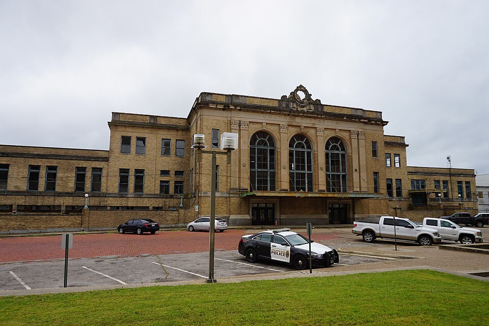
Below: Texarkana Union Station
remains standing but is in need of significant repair and restoration. (Michael
Barera photo, 2016)

Last Revised: 4/19/2025 JGK - Contact
the Texas Interlocking
Towers Page.