Texas Railroad History - Tower 145 and Tower 149 - Edinburg
Two Crossings of the San Antonio & Aransas Pass and
the St.
Louis, Brownsville & Mexico railroads in the Lower Rio Grande Valley
Above: Towers 145 and 149 were
cabin interlockers located at crossings of the Southern Pacific (SP) and
Missouri Pacific (MP) railroads near Edinburg. In the annual interlocker
reports published by the Railroad Commission of Texas, both towers made their
first appearance in the report published at the end of 1928. Tower 149 was
listed as having been commissioned on December 5, 1928 at a location identified
as "Edinburg (4 Mi. East)" while Tower 145 was listed as "Under Construction" at
Edinburg. A century later, the only rail line in the
Edinburg area that remains in service is a portion of the former SP main
line that runs north from McAllen to Edinburg, plus a short segment of
SP's former branch east from Edinburg. Both are now operated by Rio Valley
Switching Co.
In early 1903, the San Antonio & Aransas Pass
(SA&AP) Railway began to consider extending its rails south from the town of Alice toward the Rio Grande Valley of Texas,
about a hundred miles away. The Valley was not yet connected to the national
rail network, and its burgeoning agricultural production and growing population
made it ripe for rail service. The first railroad to reach it would reap the
bonanza. To finance building to the Valley, SA&AP
issued and sold construction bonds for which the bond interest was guaranteed by
Southern Pacific (SP) the major railroad system in the western U.S. SP
had maintained a close relationship from the time of SA&AP's emergence from
bankruptcy ten years earlier. SP had wanted to help SA&AP out of bankruptcy so
that a healthy SA&AP could exchange traffic with SP at several junctions:
San Antonio, Flatonia,
Eagle Lake
and Houston. SA&AP had a significant south Texas
rail network that was complementary to SP's operations. But because SP owned the
Galveston, Harrisburg & San Antonio (GH&SA) Railway, a direct
competitor to SA&AP in a few places, SP could not legally acquire SA&AP
under Texas law. The best
it could do was guarantee bond interest which made a critical difference in
establishing a market for SA&AP bonds. SP had begun pushing SA&AP to build to
the Valley before someone else did. That someone else was B. F. Yoakum.
Yoakum, a native Texan (and former SA&AP executive) had risen to become Chairman of the St. Louis & San Francisco
("Frisco") Railway and simultaneously the Chairman of the
Executive Committee of the Chicago, Rock Island & Pacific Railroad,
effectively its CEO. Both Frisco and Rock Island were major Midwest railroads
whose lines had already penetrated north Texas from Oklahoma. Yoakum's idea for
south Texas was to compete with SP along the Gulf Coast by assembling a collection of railroads that would link
Houston with New Orleans. Yoakum's marketing term for
this network was the Gulf Coast Lines (GCL.) Financially, GCL railroads
would be built or bought through a syndicate headed by the St. Louis Trust Co.
Operationally, they would be managed by Frisco executives reporting to Yoakum.
By early 1902, Yoakum's plans were clear; he intended to build a major north /
south route to link his north
Texas lines to the GCL at Houston and
Galveston. This was bad news for the several
railroads that had been carrying Yoakum's traffic between Houston and Dallas /
Fort Worth, so they began to seek ways to partner with him.
In the summer
of 1902, Yoakum's former boss, Uriah Lott, paid a visit to Frisco headquarters
in St. Louis. Lott was there to pitch Yoakum on the idea of building a coastal
line between Houston and Brownsville. Lott had been the founder and President of
the SA&AP in 1884, but left the railroad during its bankruptcy. Lott had been
pondering a Valley line for a long time, and he told Yoakum there was no
elevation gain and only a few rivers to cross; the construction expenses would
be low. Substantial bonuses and financing were available from the major cattle
growers in the area who needed better transportation options for their massive
ranches. Yoakum brought up the
fact that SP had long considered the Valley its exclusive territory to be
exploited at a future time of SP's choosing. SP would put up a strenuous fight; Yoakum was skeptical that he could beat SP to the Valley.
He
discussed the idea over lunch that day with Sam Fordyce, President of Kansas
City Southern Railway. In his biographical work
Uriah Lott (Naylor Publishing, 1949) author J.
L. Allhands describes what happened next:
"Yoakum headed Uriah back to south
Texas with instructions to run a survey from a point near Nuecestown on the
Nueces River south to the Valley. From that time forth, with one hand he held
the dreamy promoter Lott down, and with the other he loosened up bankers' and
investors' purses."
Railroad speculation was a favorite pastime of Texas
newspapers, and they occasionally reported on Lott's travels that summer and
fall. Lott was a railroad builder and a promoter, but it had been more than a
decade since his activities had amounted to anything. The story broke in the
Beeville Bee in early January, 1903...
"The meeting of B. F. Yoakum with Uriah Lott in San Antonio a few days ago,
after the former's visit to Brownsville, is the basis of gossip of a new railway
project for Brownsville, with the Frisco, of which Mr. Yoakum is president,
behind it." The plan became public when Yoakum formed a syndicate with his circle of investors
(including Fordyce) and they incorporated the St. Louis, Brownsville & Mexico
(SLB&M) Railway Company on January 12, 1903. They lacked a Texas
railroad charter, but they didn't need one at the time; they were only surveying
the route and discussing rights-of-way with major landowners. Yoakum had decided to accept the financial
risk and take on SP in a fight for the Valley. Did he have something up his
sleeve?
SP was alarmed at the news and
sought to counter Yoakum by being the
first to get rails into the Valley. Its SA&AP proxy had tracks at Alice a
hundred miles from Edinburg (Yoakum had no tracks at all in south Texas.) But just
as SA&AP began detailed planning for the construction to the Valley, the Railroad
Commission of Texas (RCT) began an investigation into SP's relationship with
SA&AP focusing on whether SP illegally possessed a controlling interest in SA&AP
stock. As part of SA&AP's emergence from bankruptcy in 1892, the Pacific Improvement
Company (PIC) had been allowed to acquire 80% of the stock in the newly
reorganized SA&AP. Mifflin Kenedy, a long time SA&AP investor, held the remaining 20%. PIC was a holding company
that owned SP along with various real estate assets; SP's chairman C. P.
Huntington owned 25% of PIC. Given that SP could not legally acquire SA&AP,
this was a suspicious arrangement indeed ... but it had been approved by the
bankruptcy judge, RCT and
SA&AP's Receiver -- its former General Manager B. F. Yoakum!
RCT held
a public hearing on April 27, 1903 and presented a report generated by SP for
the Kentucky Railroad Commission (KRC) in which SA&AP stock was listed among
SP's assets. SP and SA&AP attorneys had no choice but to admit that SP owned the
stock originally held by PIC. SP management assumed -- but could never prove --
that Yoakum had heard about the KRC report and had waited to tip off RCT until
it was to his advantage. SP came away from the hearing unsure what RCT would do,
but the hearing was public, so it was unlikely that SA&AP would have a market
for additional construction bonds until the matter was settled. There was
legitimate concern that SA&AP's
Texas railroad charter might be canceled. The timing for Yoakum couldn't have been better!
Even as the public hearing had been a disaster for SP and SA&AP, SP and other
Texas railroads were negotiating directly with Yoakum to persuade him not to extend his north Texas rails to Houston and Galveston.
Yoakum's overhead traffic was good business that they did not want to lose. In a
quandary over the RCT investigation, SP decided to capitulate to Yoakum by making him an offer he couldn't refuse.
Officially, it was a proposed
Rock Island / SP contract for sharing rail lines and traffic, a contract that would
profoundly affect the evolution of Texas railroading ... but only if RCT approved
it. Given RCT's current opinion of SP, the timing for Yoakum couldn't have
been worse!
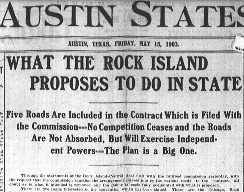 |
Left: Less
than three weeks after RCT's hearing on the illegal stock ownership
matter, the top-of-fold front page news in the
Austin Statesman of May 15, 1903
was the "Rock Island - Central deal" [Central was a nickname for SP due
to its ownership of the Houston & Texas Central (H&TC) Railroad.] The
article explained that Yoakum had agreed to buy a 48% stake in each of
four SP railroads and to route his north Texas traffic to and from the
Gulf coast exclusively on these lines in exchange for full operational
rights. The SP subsidiaries were the H&TC (Houston
to Denison), the Houston East & West Texas
(Houston to
Lufkin to
Shreveport), the Galveston, Houston & Northern (Houston
to Galveston) and the Texas & New Orleans (Dallas
to Beaumont,
Houston to
Orange.) SP was to retain 48% ownership,
and the other 4% would be held by a neutral party.
RCT interpreted the contract as ceding effective control of the four SP
subsidiaries to Yoakum, constituting in essence a partial merger or
joint venture between SP and Rock Island. RCT analyzed the contract by
looking at various laws passed by the Legislature granting railroad
mergers. It found there was little difference in the details of the
legislative enactments compared to the terms of the proposed contract.
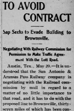
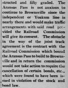
An Austin Statesman story
on May 21 explained that the contract did "...not require the Rock
Island to build one mile of track nor one house [depot] of any kind, and
still the company acquires all of the benefits and advantages as if the
matter had come before the Legislature without any disguise, as a
straight merger proposition." The story went on to predict that this
argument would "...form the several grounds upon which the commission
will refuse..." to approve the contract. Two days later -- only nine
days after receiving the proposed contract -- the Commissioners voted 2
- 1 to deny approval. As a result, Yoakum changed strategy, aggressively
moving to compete, rather than cooperate, with SP. |
Wasting no time, Yoakum proceeded to charter the St. Louis, Brownsville & Mexico (SLB&M) Railway
on June 6. It became the first of the GCL railroads, and he hired Lott to build it. In August, Lott
initiated construction south toward Brownsville starting at
Robstown to which materials could
be shipped from the Port of Corpus Christi on the Texas Mexican
(TM) Railway. [Lott had built the TM rail line between Corpus Christi and Laredo in the 1870s.] In July,
1903, RCT's final settlement with SP and
SA&AP was announced wherein SA&AP was allowed to retain its Texas railroad
charter, but was required to cancel all of the stock held by SP (reducing
SA&AP's authorized capitalization from $5 million to $1 million.) SP was
prohibited from guaranteeing interest on any new SA&AP bond issues, but it was
required to continue to back the bonds that had already been sold. SA&AP was
ordered to destroy any unsold bonds that carried SP's interest guarantee.
 |
 |
RCT's July order removed all traces
of SP ownership, leaving Mifflin Kenedy's heirs as the SA&AP's new
owners. RCT subsequently allowed SA&AP to retain and sell its remaining
SP-backed bonds in exchange for a commitment to build from Alice through Edinburg to Brownsville. Two months
after RCT's order -- and one month after Lott had begun SLB&M
construction toward Brownsville -- SA&AP construction began at Alice in
September, 1903. The race to the Valley was on!
The following
spring as SA&AP reached Falfurrias, 36 miles from Alice, the
construction stopped unexpectedly. In his reference tome,
A History of the Texas Railroads (St. Clair
Publishing, 1941), author S. G. Reed (who began
his railroad career as a traffic manager for SA&AP in
Victoria) explained the
prevailing theory of why SA&AP's extension to the Valley ended abruptly:
"The project was dropped, in June, 1904,
for lack of funds and also to quiet the Railroad Commission. The reason
officially assigned for discontinuing work was that there was not enough
traffic in the Valley to support two lines, but another reason was
surmised and may have been controlling, which was that [E. H.] Harriman,
who then controlled the S. P., and Yoakum had effected a mutually
satisfactory agreement for preferential routing of traffic between their
respective systems. It is known that some such agreement was effected
about that time and it continued for many years, but that it involved
the abandonment by the S. A. & A. P. of the Valley extension is only a
surmise."
Left: SA&AP's interest in building to
Brownsville waned with the "Yoakum line...nearly there." RCT relented,
allowing SA&AP to
stop at Falfurrias and defer
construction to Brownsville. (Brownsville Daily
Herald, May 24, 1904) |
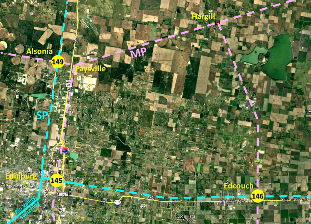
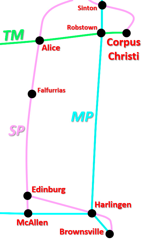
Right: overview map showing main lines and major
branches in the Lower Rio Grande Valley
With SA&AP stalled at Falfurrias, Lott completed
SLB&M construction to Brownsville in 1904 and then
built north to
Algoa. In the spring of 1908, Yoakum negotiated
trackage rights from Algoa into Houston
on the Gulf, Colorado & Santa Fe Railway. The resulting Houston -
Brownsville main line gave Yoakum exclusive control of Valley traffic for nearly
two decades during which additional branch lines were built. Frisco / GCL tracks
in the Valley eventually consisted of the north / south main line to Brownsville and
a lengthy branch line from Harlingen west to Rio Grande City. The
San Benito & Rio Grande Valley (SB&RGV) Railway, founded by
Frisco interests but not part of the GCL, built 65 miles of
tracks in the Valley that functioned as additional branch lines for SLB&M.
The Frisco acquired the GCL railroads from the St. Louis Trust Co.
in 1910, but this did not help the Frisco avoid receivership in 1913.
The bankruptcy judge separated the GCL railroads from the
Frisco, making them independent with a true corporate structure. A revised Louisiana
railroad charter was established for an existing GCL railroad, the New Orleans, Texas & Mexico (NOT&M) Railroad,
under which the NOT&M became the owner of all of the other GCL railroads. The
NOT&M also proceeded to acquire the SB&RGV in 1916 and the International & Great
Northern (one of the largest railroads in Texas) in 1924. On
January 1, 1925, Missouri Pacific (MP) acquired the NOT&M with
approval by the Interstate Commerce Commission (ICC.) MP was a major Midwest
railroad based in St. Louis, a direct competitor to both Frisco and Rock Island.
MP's previous venture into Texas railroading in the 1880s under rail magnate Jay
Gould had fallen apart through court rulings and bankruptcies, so MP no longer had a presence in Texas. With its NOT&M
acquisition, MP immediately became SP's major competitor in Texas.
In the
Transportation Act of 1920, Congress had directed the ICC to promote and plan the consolidation of U.S. railroads into a
limited number of "systems". The ICC responded by hiring economist William Z.
Ripley to develop a plan. The so-called Ripley Plan proposed that SP
head one of these systems and that SA&AP become part of it. Although the Ripley
Plan was never formally implemented, the authority of the ICC to regulate
interstate railroads granted by the Act overrode the power of state railroad
commissions. Knowing that MP's acquisition of NOT&M was imminent, SP applied to the ICC
on December 6, 1924 for permission to acquire SA&AP. The State of Texas opposed the move, but was overruled by the
ICC, which granted SP's application. In March, 1925, SA&AP was acquired
(legally!) by SP and then leased to GH&SA. In 1926, SP directed SA&AP to resume building to
the Valley, which by this time could easily support a second railroad. |
 |
SP's
planned construction toward the Valley
prompted MP to build branch lines into the
area north of Edinburg, hoping to capture customers before SP arrived. The primary branch departed west from
the SLB&M main line at Raymondville and went to Monte Christo via Lasara,
Hargill and Faysville. Secondary branches ran from Hargill south to
Edcouch and from Faysville
south to Edinburg. In Edinburg, the line from Faysville connected to an existing
10-mile branch that came north from San Juan, a community on SLB&M's east / west
line between Harlingen and McAllen. This effectively created a north / south line
from San Juan to Faysville that offered
an alternate route for SLB&M's McAllen traffic to access the main line through Raymondville
instead of Harlingen.
In January, 1927, SA&AP's tracks from Falfurrias
reached the
western Valley, crossing MP's new branch to Monte Christo about
eight miles north of
downtown Edinburg. A cabin interlocker, Tower 149, was installed at the crossing
and commissioned by RCT on December 5, 1928. Tower 149 was near the communities
of Alsonia and Faysville, and SP's internal documentation mentioned both. RCT
annual reports identified Tower 149's location as "Edinburg (4 Mi.
East)" because in SP's employee timetables, trains moving geographically north
in the Valley were traveling eastward. Tower 149 was four miles north of
a freight yard and wye SP built on the north side of Edinburg, and this
was apparently the base for RCT's identification of Tower 149 as "4 Mi.
East."
Right: An article in
the Brownsville Herald
of November 13, 1927 looked back at SP's arrival in the Valley earlier
that year. It noted that a SP executive had driven a golden spike at
Edinburg on January 11, 1927. |
 |
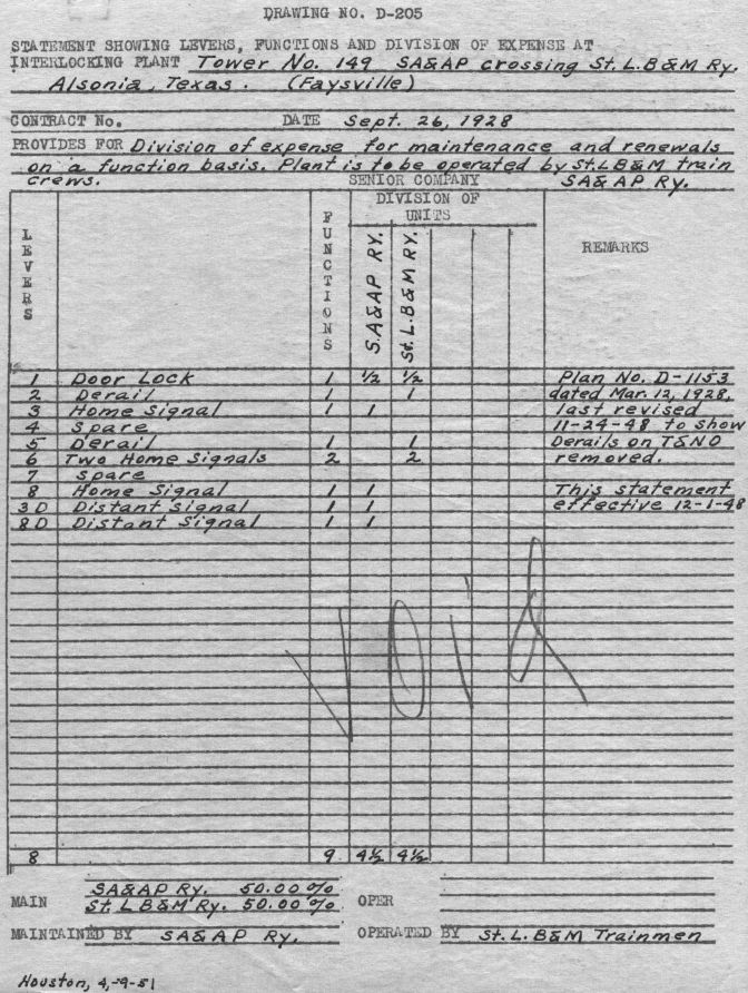 |
Left:
(Carl Codney collection) RCT listed Tower 149 as an 11-function
"M-Cabin" (mechanical cabin interlocker.) This is confirmed by
the "D-205" documents with which SP summarized the scope and
functionality of each of its interlocker agreements. This one -- a
revision to the original D-205 for Tower 149 -- shows the initial contract DATE of September 26, 1928
which was a couple of
months prior to when RCT commissioned it. Notes in the
REMARKS column indicate the
design was
dated March 12, 1928, about nine months before the interlocker was
commissioned but well after the crossing had opened (a period during
which all trains stopped at the crossing every time.)
Changes
were noted November 24, 1948 "...to show derails on T&NO removed"
effective December 1, 1948. This reduced the total function count from
11 to 9, resulting in a 50 / 50 split on maintenance expenses (4.5
functions for each railroad.) The prior allocation was 6.5 / 4.5
resulting in a 59 / 41 expense split with SA&AP paying the larger share.
Curiously, "SA&AP Ry." is listed
as the SENIOR COMPANY. This was incorrect; SLB&M's
tracks had reached the site before those of SA&AP.
Tower 149 was a cabin interlocker OPERATED BY "St.LB&M trainmen"
(reemphasized with "Plant is to be
operated by St.LB&M train crews.") indicating that the controls were
normally lined so that SP's main line had unrestricted movements. All SLB&M trains
would stop, a crew member would enter the cabin to set the signals for
his train
to cross, and then he would reset them when the train's passage was
complete. The
plant was MAINTAINED BY "SA&AP Ry."
Unlike MP
trains which always stopped, SP trains were usually moving across the diamond
at track speed, hence SP had the larger incentive to ensure that the plant,
the signals and the diamond were well-maintained.
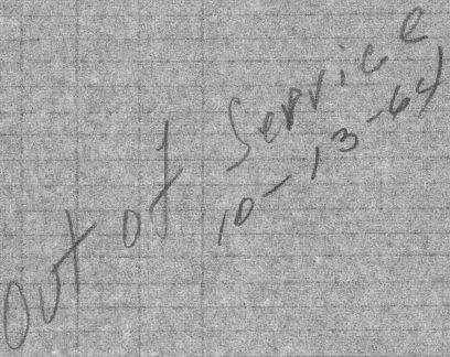
"Void"
was scrawled across
the document when a newer (typewritten) D-205 was issued in December, 1955
to add approach signals for the SLB&M. The new expense split was 55 / 45
with SLB&M paying the larger share. On that document,
a handwritten notation (below)
reports the plant "Out of Service" on October 13, 1964.
 |
Although SENIOR COMPANY was defined as the
railroad whose tracks reached the future crossing site first, RCT construction records
show that SA&AP was the second railroad at the Tower 149 crossing, not the
first. MP's branch to Monte
Christo was completed in 1926, hence SLB&M should have been the SENIOR COMPANY
at Tower 149.
This was important because RCT's rule for post-1901 crossings (such as this one) was that the SENIOR COMPANY
was exempt from the capital expense of building and installing the interlocking
system; all capital costs were borne
by the other railroad. [Once operational, both railroads shared
recurring expenses, e.g. utilities, operations staffing (at manned towers) and maintenance.]
Why was SA&AP listed as the SENIOR COMPANY?
One
speculative possibility is that SP and MP swapped interlocker construction
projects; the reverse situation occurred at
Tower 151. There, SP's branch to Brownsville was
completed in 1927 and in 1928, a branch from San
Benito to Abney was built by SB&RGV (MP) and extended to Port Isabel in 1941. MP's line crossed SP's tracks at the future
site of Tower 151, yet
SP's documentation lists the SB&RGV as the SENIOR COMPANY
at Tower 151. Whether these locations were paired for an apparent swap of construction responsibility
is unknown, but it might relate to Tower 147, less than ten miles from Tower 151.
At Tower 147, SP rightfully had the obligation to build the interlocking because it was
not the SENIOR COMPANY. SP may have preferred to design and
build Tower 151 at the same time it was designing and building Tower 147 since
they were only ten miles apart (and were commissioned by RCT a month apart in
the spring of 1929.) Significantly, both interlockers would be operated by MP
train crews with the signals normally lined for SP trains. Those crews were
likely to encounter both of the interlockers periodically as they worked out of
San Benito, so an argument could be made that familiar controls would enhance
safety and operations. For MP's part, there was no
obvious reason to prefer to build Tower 149 rather than Tower 151.
SP's main line continued geographically south from Tower 149 into downtown
Edinburg and then farther south to McAllen. About 6.7 miles from Tower 149, SP began a 63-mile branch line from
Edinburg to Brownsville as originally envisioned by SA&AP's 1903 deal with RCT. It departed the main line from what SP called
Edinburg Junction and
proceeded east, crossing SLB&M's San Juan - Faysville line within the first
mile. There, Tower 145, a cabin interlocker presumably built by SP was
commissioned by RCT on January 3, 1929. RCT
records identify the site as Edinburg Junction despite being a mile east of SP's Edinburg Junction.
RCT's documentation shows Tower 145 as an 11-function "M-Cabin", very
likely with
the same eleven functions as originally used at Tower 149. Twelve miles farther
east at Edcouch, SP had another crossing of the SLB&M; it was interlocked in
February, 1929 as Tower 146.
 |
Left: The
August, 1943 issue of Railway Signaling
carried this news item regarding changes to the Tower 145 interlocker. |
Valley competition between MP and SP continued essentially unchanged
into the 1960s. RCT documentation states that MP abandoned the nine miles from Faysville
west to Monte Christo in 1957. This should have eliminated the need for Tower
149, but as shown above, SP did not take the plant out of service
until 1964. MP still had tracks into Faysville until 1964, so it's likely MP
left the rails intact farther west past Tower 149 should the line need to be reactivated.
MP's tracks from Hargill to Faysville were abandoned in 1964
along with the eight miles from Faysville south to Edinburg. This undoubtedly
spurred the decision to
decommission Tower 149 as MP rails were no longer nearby.
MP's track abandonment
south of Faysville eliminated the need for Tower 145 and it was probably
decommissioned at that time. MP continued to serve Edinburg via the short
connection north from San Juan (abandoned in 1971.) In 1979, SP abandoned its
main line into the Valley from Falfurrias and began sharing MP's main line south
from Sinton, but SP retained its Valley branch lines. Many of these tracks were later abandoned, but
SP's 12-mile line from McAllen north to Edinburg remains in service by Rio
Valley Switching Company (RVSC) as does a short segment east from Edinburg Jct.
past the site of Tower 145.

Above: This
annotated Google Earth image of the Tower 145 crossing shows the historic location
of the main lines and nearby support tracks. All of these tracks have been
removed except a segment of the former SP branch line toward Harlingen which
remains in use by RVSC as a storage track ending a mile east of the Tower 145 crossing
(annotations by Noe Gutierrez.)

 |
Far Left: Noe Gutierrez took
this May, 2019 photo of a concrete pedestal with steel inserts at the site of
the former Tower 145 cabin, purpose undetermined.
Left:
the view north along the MP right-of-way from the Tower 145 crossing (Noe
Gutierrez photo) |

 |
Far Left:
This 1955 image shows the Tower 145 cabin sitting in the
northwest quadrant of the MP / SP crossing casting a visible shadow to the north.
((c)historicaerials.com)
Left: Google Earth
imagery from October, 2016 shows the tracks east of the former Tower 145
crossing being used for car storage. Imagery from May, 2025 continues to show
stored railcars. |
When Noe Gutierrez traveled to Edinburg in May 2019, he stopped
in the Faysville area to take a look at the site of Tower 149. Noe describes his
visit:
"The last place I intended to visit on the way in was the old Tower 149 site
west of Faysville. I couldn't - it turned out the road paralleling the old MP
line to Monte Christo (aka Monte Cristo) is the private main entrance to Lamar
Farms with very large 'No Trespassing' signs all around. I managed to talk to a
worker leaving the farm who directed me to drive on in and talk to the folks in
the office of a produce packing warehouse next to the old tower site. I was
given the name of the landowner, Chris Burns, whom I called and left a voice
mail telling him who I was and what I wanted to do there.
The next
morning, not having heard from him, I called again. I spoke with him and he
agreed to allow me to conduct my field checking in the area of the old tower but
requested I go no further west. I drove out there right afterward and began
taking pictures. Mr. Burns himself soon drove up and we had an interesting
conversation. ... He knew of the old rail lines that used to cross his property
and stated he'd found at least a hundred spikes over the years.
His
manager then drove up, a gentleman older than both of us, and he recounted the
time when the 'narrow gauge' line ran down where we were standing. He further
stated that the main road, unpaved many years ago, ran down the old MP roadbed.
I asked if I could possibly venture on down to where the road jogged to the
north slightly where parallel fence lines 40 feet apart were located. Mr. Burns
again said he'd rather I not go down there and that there was really nothing to
see there. His manager stated that the old MP line used to run down the middle
of those two fence lines. They then departed down that road to tend to farm
business and left me to finish my pictures. Very nice people them.
I
already knew the manager must be mistaken about the old MP line being narrow
gauge as the San Benito & Rio Grande Valley HAD to be standard gauge to
interchange with the St Louis, Brownsville, & Mexico. Further research using old
aerial photographs revealed the manager to be partly correct about the location
of the old MP line. The main drive was NOT located on top of the old roadbed, at
least not for the first 2.25 miles. After that the road continues on, either as
a paved road, dirt road, or field access road for another seven miles to where
the only evidence of the old line shows up, beyond the north end of Cantu Road,
presumably where the failed community of Monte Christo used to be. Here the line
turned to the south to head to Alton and Mission. While the rail line may have
remained fixed in place until it was abandoned, the road(s) along it did not.
They were moved over the years, sometimes parallel to the railroad, and
sometimes moved to the old roadbed. Those must have been the instances the
manager was recalling.
I found no evidence of old rail infrastructure at the site, and there was
construction traffic moving through there in connection with a pipeline being
built. Old aerials show the interlocking cabin was located in the NE quadrant of
the site, though. Mr. Burns had also stated that the tree line on the east side
of the old SP ROW was 'virgin' in that it had not been touched since the
abandonment."

Above: Tower 149 is depicted
in the northeast quadrant of the MP / SP crossing on this annotated Google Earth
image provided by Noe Gutierrez. All of the tracks in this area were abandoned
many decades ago, the most recent being the north / south SP main line in 1979.
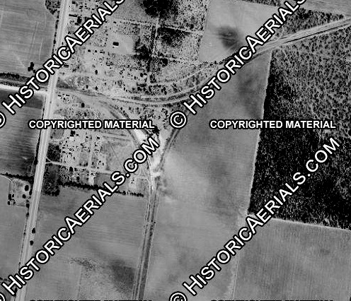
Below Left: Located in the
northeast quadrant of the diamond, the cabin that housed the Tower 149
interlocker casts a distinct shadow to the north in this 1955 aerial photo ((c) historicaerials.com.)
Below Right: SP documentation
described the Tower 149 cabin as located at "Alsonia, Texas (Faysville)."
Alsonia no longer appears on county maps, but it appeared on this US Army Corp
of Engineers map from 1930. Highlighted are Alsonia (green), the Tower 149
crossing (red) and Faysville (blue.) SP timetables from the 1930s list Alsonia
as 1.8 miles north of Tower 149 which matches its latitude / longitude assignment
in the US Geologic Survey Domestic Names database. Satellite imagery does not indicate there was ever a railroad stop or
any other activity besides agriculture at Alsonia. (map, University of Texas, Perry
Castaneda Library)


Above Left: This 1955 aerial
image of MP's junction at Faysville ((c) historicaerials.com) shows that it
formed a wye so that the branch south to Edinburg was accessible from either
direction on the Raymondville - Monte Christo tracks. Note that the tracks to
the west joined just east of the crossing of U.S. Highway 281.
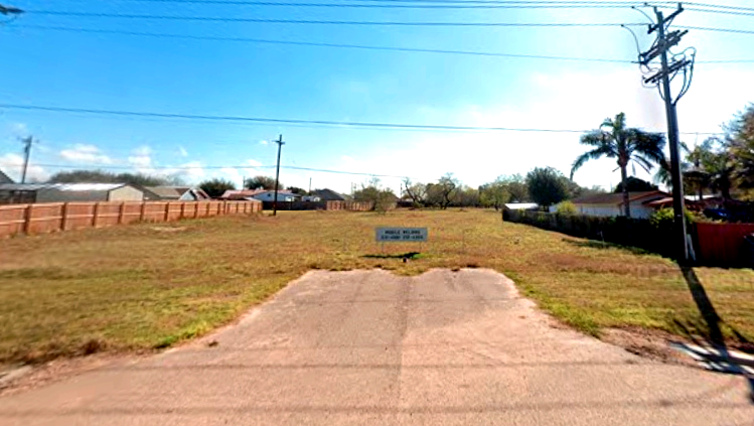
Above Right: ...which explains
this "no-man's land" between two housing subdivisions looking east from the
northbound frontage road of U.S. 281 (now I-69.) The sign is advertising mobile
welding services. (Google Street View, Feb. 2025)
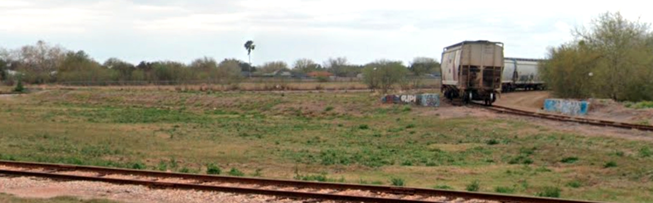
Below: SP's Edinburg Junction still has tracks where Rio
Valley Switching Co. accesses the stub of the former branch toward Harlingen and
Brownsville now used for railcar storage. This Feb. 2025 Google Street View
faces northwest with the former SP main line vaguely visible in the distance.
The railcars are on the northeast connector; the southeast connector is in the
foreground. Like the railcars, the concrete platforms (no doubt left behind by
SP) serve as palettes for the local graffiti artists.

Last Revised: 11/25/2025 JGK - Contact the Texas
Interlocking Towers Website