Texas Railroad History - Tower 64 - Greenville
A Crossing of the Missouri - Kansas - Texas Railroad and the St.
Louis Southwestern Railway
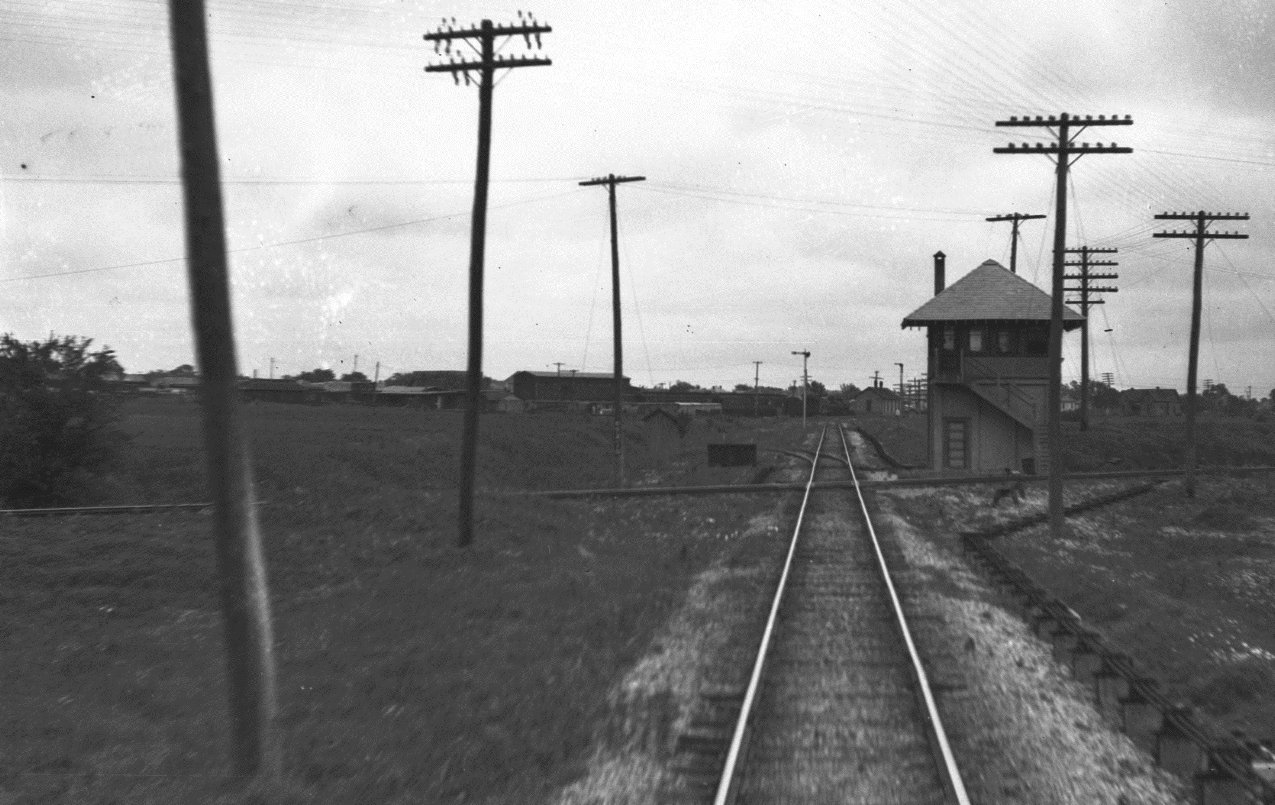
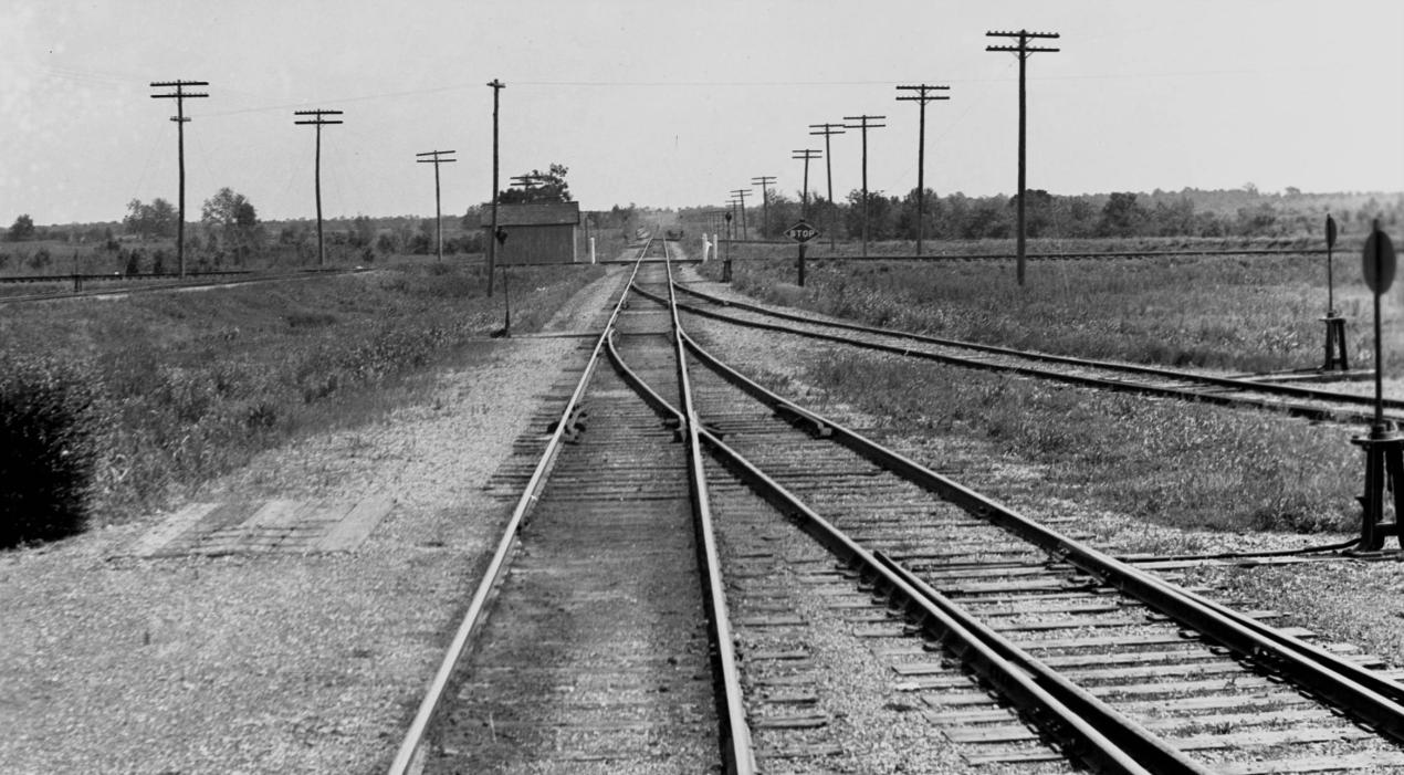
Above: John W Barriger III took this photo of Tower 64
from the rear platform of his private railcar in the 1930s or early 1940s as his
train left Greenville headed southwest toward Dallas on tracks of the Missouri-Kansas-Texas ("Katy")
Railroad. The Katy's Hunt Yard is visible in the distance.
Tower 64 was a Katy tower with a concrete, first floor base, similar in design to Tower 53 and
Tower 93. (John W
Barriger III National Railroad Library)
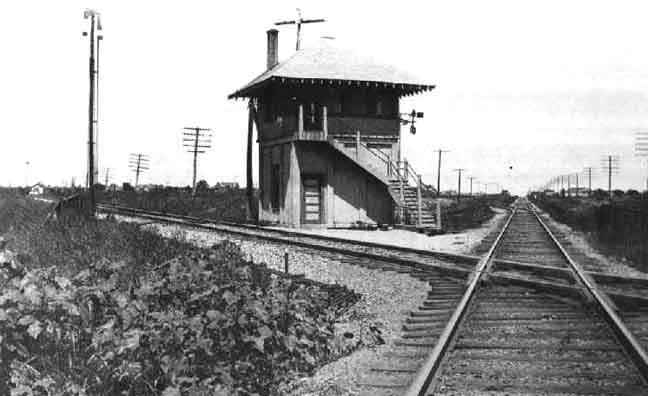
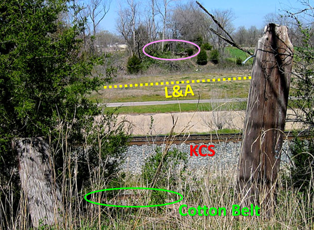
Below Left: This
photo from the 1930s appeared in the 2001 Katy Lines Calendar produced by the
Katy Railroad Historical Society. The track straight ahead is looking toward
Commerce on the St. Louis Southwestern (Cotton Belt). The track to the left is
the Katy line into Greenville from Dallas.
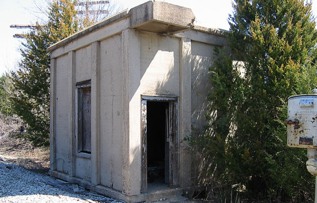
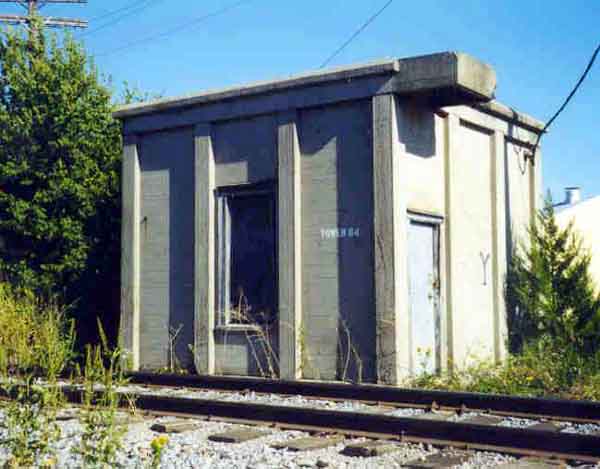
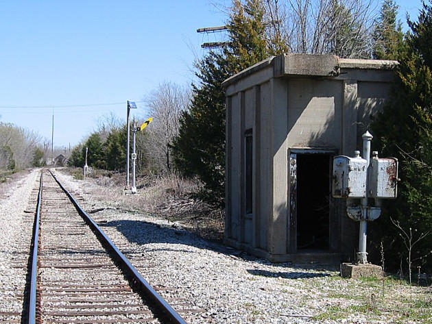
Below Right: When Tower 64 was decommissioned, the wooden upper
floor was removed but the concrete bottom floor was left intact, and remains so
today. The concrete square that sits above the door was the second floor landing
for the staircase. (Greg Harrison photo, 2008)
The town of Greenville was founded when Hunt County was
created by an act of the Texas Legislature in 1846. Some 30 years later, the
first railroad arrived when the East Line and Red River (EL&RR) Railroad reached Greenville
in 1876. The EL&RR was the brainchild of citizen-investors in the east Texas town of Jefferson,
the largest town in north Texas at the time and a major river port whose economy was threatened by the burgeoning railroad
construction in Texas. Hoping to avert a crisis, they funded a narrow gauge railroad
to build west from Jefferson to McKinney and east to Shreveport. Upon reaching Greenville
in 1876, the EL&RR paused construction, apparently due to lack of financial resources.
By the time the EL&RR reached Greenville, the Missouri-Kansas-Texas (MKT,
"Katy") Railroad had already built across the Red River and established a base
in Denison in 1872. While the Katy pondered its next move, the Missouri-Kansas-Texas Extension Railway
built from Denison to Greenville in 1880. The railroad had been chartered as
the Denison and Southeastern Railway, but during construction, the
"Extension" name was adopted to tempt the Katy into buying the line. The
temptation succeeded, and in 1881, the Katy continued this line beyond Greenville
to the southeast, building fifty additional miles to Mineola where a connection to
the Texas & Pacific (T&P) Railway was made.
In 1881, the Katy
bought the EL&RR and directed it to proceed with the 32-mile narrow gauge branch to McKinney
as originally planned. The Katy also sponsored the Dallas & Greenville Railway
to build a 52-mile track between the namesake cities. Construction was completed
in 1886 and the route was formally acquired by the Katy at that time. That same
year, a new Texas Attorney General was elected on a campaign to go after the
railroads for non-competitive activities. For purchasing the EL&RR, he proceeded
to sue the Katy in 1887 for non-compliance with Texas' railroad ownership laws.
In 1890, the Texas Supreme Court confirmed a lower court's order that the Katy
forfeit the EL&RR charter. Placed in receivership, the bankruptcy court directed
the EL&RR Receiver to issue receiver certificates to pay for converting the
Greenville - Jefferson segment to standard gauge (the Katy had converted the
McKinney segment in 1887.) The conversion was completed in 1892 and the entire
railroad was sold to the newly chartered
Sherman, Shreveport and Southern (SS&S) Railway in 1893.
A law passed
by the Legislature and signed by the Governor in 1899 allowed for a legal
reorganization of Katy rail lines in Texas; this put the Katy back in compliance with
Texas law. Motivated by the new law, the Katy acquired the SS&S in 1901
to regain possession of the original EL&RR route. This lasted until 1923
when the Katy's reorganization out of bankruptcy resulted in the entire route
from McKinney to Jefferson (and beyond, to Waskom) being sold to a newly
chartered, Texas-based subsidiary of the Louisiana Railway & Navigation Co.
(LR&N). The Louisiana & Arkansas (L&A) Railway then bought the LR&N in 1929, and
in turn, was bought by Kansas City Southern (KCS) Railway in 1939. The following
year, now operating as a KCS subsidiary, the L&A abandoned the tracks to
McKinney west of Farmersville, but the Greenville to Farmersville segment was
retained. At least by 1956 (and probably much earlier), the L&A had established
a connection at Farmersville with the Gulf, Colorado & Santa Fe Railway line
that went south to Dallas. At some point, KCS gained access to the Dallas/Ft. Worth
market via this connection. The L&A was fully merged into KCS in 1992, and the
following year, KCS purchased the Santa Fe tracks south from Farmersville giving
it access to Dallas on its own tracks.
The common heritage of KCS and the
Katy involving the EL&RR route resulted in KCS taking over Katy's Hunt Yard in
later years as the Katy lines through Greenville were deemphasized and
eventually sold. The Katy branches to Denison (which now goes to
Sherman instead) and Dallas are owned by Genesee &
Wyoming. Its subsidiary, the Dallas, Garland and Northeastern (DGNO) Railroad,
operates the lines and uses two switches and 500 ft. of KCS track to cross
between them. The former Santa Fe line north of Farmersville through Celeste and
Wolfe City to Paris was abandoned in 1995 and its
right-of-way (ROW) is
now part of the Northeast Texas Trail.
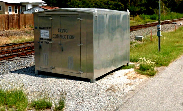
Above: About 500 ft. of the
KCS line through Greenville is now shared with DGNO so they can cross between
their line to Dallas and their line to Sherman. The switch for Dallas is east of
Wellington St. and for Sherman, the switch is west of Texas St.
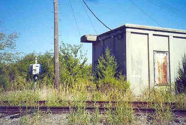
Below Left: The equipment cabinet for the
Dallas switch for DGNO off the KCS sits trackside slightly east of Wellington
St. (2013 Google Street View)
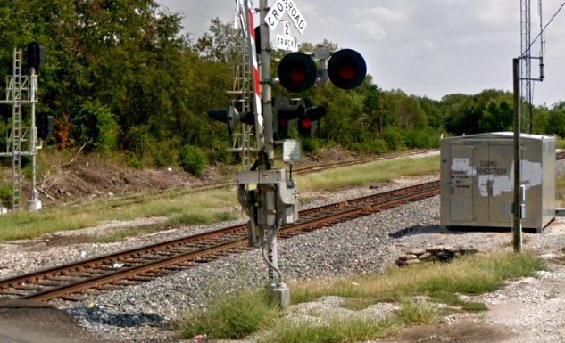
Below Right: Facing east,
the DGNO track to Sherman is visible having just branched off of the KCS main
line west of the Texas St. grade crossing. (2013 Google Street View)
In 1887, the St. Louis, Arkansas & Texas (SLA&T) Railway built a line
from Commerce to Renner (near Dallas) that passed through Greenville. The SLA&T went bankrupt
in 1891 and its assets were taken over by the St. Louis
Southwestern (SSW, "Cotton Belt")
Railroad. The Cotton Belt ultimately served both Dallas and Fort Worth, providing
service via Greenville back to Texarkana and points east. The Cotton Belt was
eventually consolidated into Southern Pacific (SP). When Union
Pacific (UP) merged with SP in 1995, the Cotton Belt line from Sulphur Springs to
Dallas via Greenville was no longer needed, so the Northeast Texas Rural Rail
Transportation District (NETEX) was created to acquire the property and operate
it.
In 1895, the Texas Midland (TM) Railroad built due north into
Greenville from Roberts, a distance of 19 miles. TM had acquired the Texas
Central Railroad's existing track from Ennis to Roberts, and the line into
Greenville was a northerly extension heading for a connection with the St. Louis San
Francisco Railway in Paris. Since the Cotton Belt already had a line from
Greenville to Commerce, TM arranged trackage rights to Commerce and continued
construction north from there. In 1923, TM built their own line between
Greenville and Commerce, paralleling the Cotton Belt. In the early 1930s, TM was
bought by SP. Since SP controlled the Cotton Belt, the TM's duplicate line to
Commerce was unnecessary; it was abandoned in 1933 with much of the ROW being used for a state highway.
By 1923, Greenville
had nine rail lines radiating out in all directions!
Yet, despite several grade crossings, only one interlocking tower was ever authorized
in Greenville by the Railroad Commission of Texas (RCT).
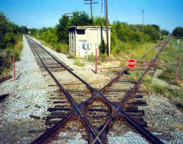
Tower 64 was established on September 24, 1906 at a crossing of the Cotton Belt
and Katy railroads on the west side of Greenville, a short distance southwest of
Katy's Hunt Yard. The 20-function mechanical interlocker protected the crossing for decades, but was
eventually decommissioned (precise date unknown.) The upper portion of the tower was
dismantled but the concrete base remains intact. After the interlocker was
removed, the crossing
was protected by a swing gate. The Tower 64 diamond still exists, but neither
track is operated by a major railroad and traffic is sporadic.
 |
Left:
This 1923 Sanborn Fire Insurance index map has been annotated to show the nine rail lines
radiating out of Greenville. Five had been Katy; three remained but the L&A
had taken over the
Katy's EL&RR route. It remains intact for KCS, east to Shreveport and west to Farmersville where it turns south to Dallas on
former Santa Fe tracks. L&A abandoned the tracks west of Farmersville in
1940. Katy's Hunt Yard was built at the junction of the Dallas line and
the EL&RR, and is now a KCS facility.
The Katy branch to Mineola was abandoned in 1956; parts
of the ROW succumbed to US
69's expansion. The Katy line to Dallas remains
intact, but the former Denison branch now merges at
Bells with former T&P tracks and goes to
Sherman instead. Through Greenville, these former Katy branches are now
operated by DGNO. A Katy maintenance
facility (M) was located near the junction of the Katy lines.
The Texas Midland
(TM) tracks to Commerce were abandoned in 1933, a mere 10 years after
construction. This was due to SP's acquisition of the TM. SP also
controlled the Cotton Belt so it didn't need parallel lines to Commerce.
Much of the TM right-of-way to Commerce was used for Texas
Highway 224. South of Greenville, the TM was abandoned to
Kaufman in
1958. Sixty-six miles of the Cotton Belt through Greenville and Commerce is now owned by
NETEX and operated by North East Texas Connector, LLC. The track begins
two miles west of the Tower 64 crossing to serve a chemical plant
(beyond this point, the ROW is abandoned to Wylie.) To the east, NETEX
ownership ends at the
west edge of Sulphur Springs. The TM crossed three railroads at grade in Greenville. |
Above
Left: A swing gate protects the
crossing, but weeds along the former Cotton Belt tracks to the east indicate sparse traffic.
Above Right: The concrete base of Tower 64 remains intact, with an abandoned interlocker
control stand nearby (c.2000, Myron Malone photos) Below Left: "Tower 64" is stenciled on the side
of the tower. (c.2000, Myron Malone photo) Below Right:
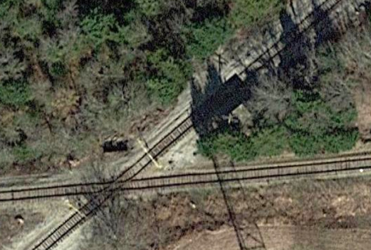
Tower 64 sits northeast of the diamond and casts a sharp-edged shadow across the
former Katy tracks. Both lines were headed to Dallas, hence the acute angle of
the crossing. (Google Earth, Nov. 2018)
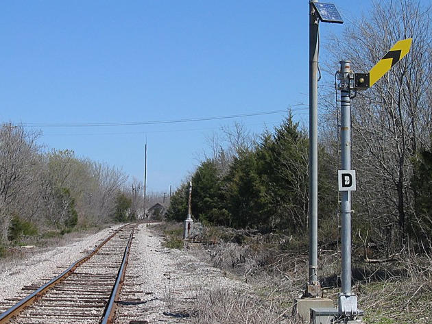
Above Left: What's left of Tower 64 sits abandoned with an "advance-approach"
semaphore in the background. Above Right:
This is the distant signal for DGNO trains approaching the KCS interchange. It's
rare to see a new semaphore signal. Note the solar power pole adjacent to it.
(Greg Harrison photos, c.2008)
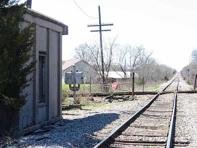
Above Left: The camera is looking southwest down the
former Katy tracks while the gate is swung across the former Cotton Belt line.
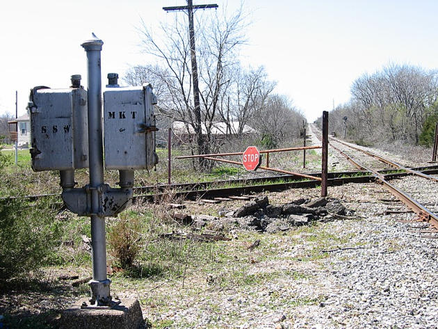
Above Right: This close-up of
the signal control box (manufactured by Union Switch & Signal Co.) shows that it
was stenciled for the two railroads. After the tower was no longer manned but
the interlocker was still in place, the controls allowed a train crewmember to
line the signals manually before crossing if a proceed indication was not
already displayed when approaching. (Greg Harrison photos, c.2008)
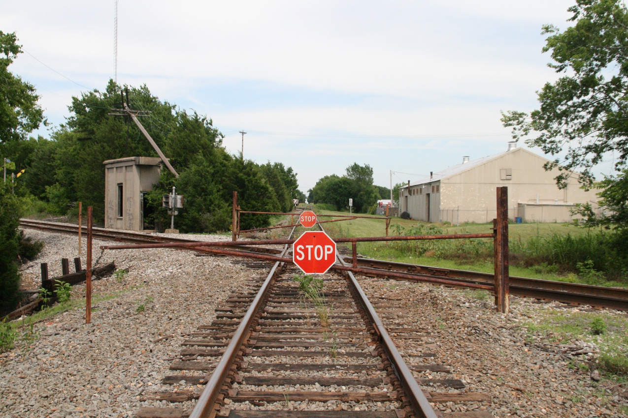
Below: Stop signs and gates
are across the Cotton Belt in this photo taken June 6, 2009. (Jason Lee Davis
photo)

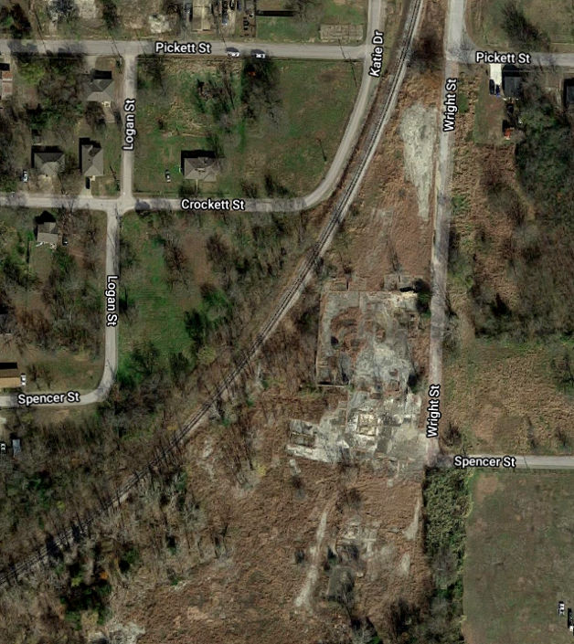
Above Left: The Katy maintenance facility in Greenville
mostly sat west of Wright St. and north of Spencer St. This image from the 1923
Sanborn Fire Insurance map of Greenville shows there was a turntable and other
structures. Unfortunately, the facility straddles a break in the map sheet so it
does not show the western edge, which was the Katy track that curved north to
reach the Denison branch. The "Main Track" label to the right and slightly below the turntable marks
the Katy branch to Mineola which was a southerly continuation of the line from
Denison. Above Right:
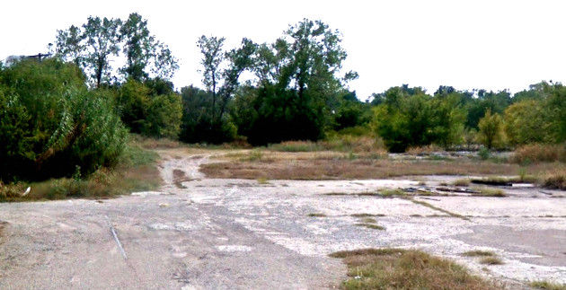
This 2018 view from Google Earth shows that although the maintenance facility
was removed, the land has not been repurposed.
Below: Two 2013 Google Street Views of the Katy's maintenance
area show industrial remnants but not much else. At left, the view is northwest
from the corner of Spencer and Wright. The rail embedded in Wright St. was part
of the main line to Mineola. At right, the view is south on Wright where it
dead-ends at Spencer. The branch to Mineola continued south into the brush,
crossing over the L&A and the Cotton Belt tracks on two bridges.

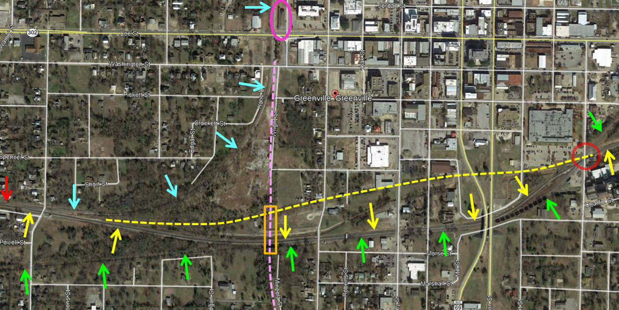
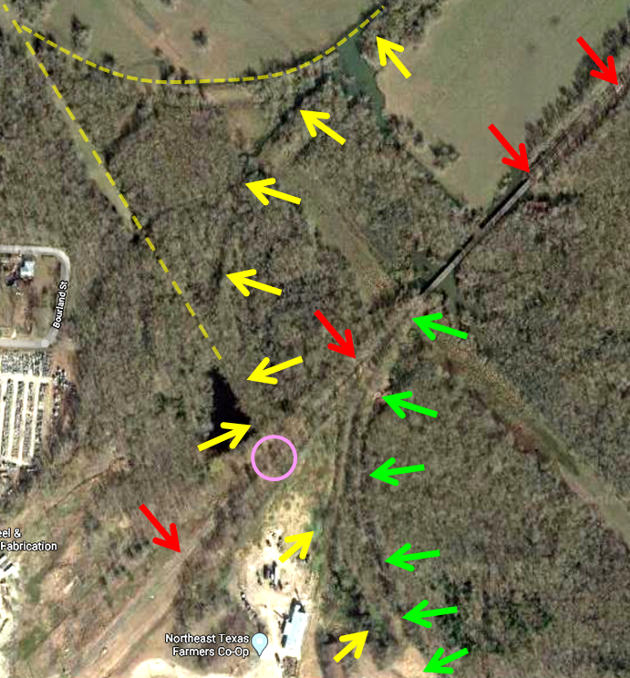
Above: This Google Earth
satellite image of the south side of downtown Greenville has been annotated to
show the current and abandoned rail lines in this area. The KCS main line
(yellow arrows) runs generally east/west through through town, with Hunt Yard
being off the map to the left. The L&A ROW originally (yellow dashed line) ran
farther north, but the track was rerouted to share a portion of the former Cotton Belt
(green arrows) ROW, eliminating several grade crossings.
The KCS and Cotton Belt tracks still cross at an acute angle (red circle) on the
east side of town. The Katy line to Denison (blue arrows), now a DGNO line to
Sherman, departs the KCS main at a switch (red arrow) at far left and curves
north to go past the former Katy depot (pink oval). Katy's
Dallas line was actually a branch off of the main line that came in from Denison
because the Denison line continued due south (pink dashes) to become the line to Mineola.
The Mineola track
crossed over the L&A and Cotton Belt tracks on two bridges and a fill (within
the orange rectangle.)
Below Left: This image
taken by Greg Harrison c.2008 faces north from the south side grade of the
former Katy branch to Mineola. The total
distance was approximately 350 ft. to cross
both the Cotton Belt on the south side and the L&A on the north side, but
historic aerial imagery shows that this was implemented as two short bridges
with a fill between them. Bridge remnants on the north side (pink oval) and
south side (wood in foreground) remain. In later years, KCS abandoned the L&A ROW in this area
and a new track segment was built closer to the Cotton Belt ROW. By then, the
bridges and the fill between them had long been removed.
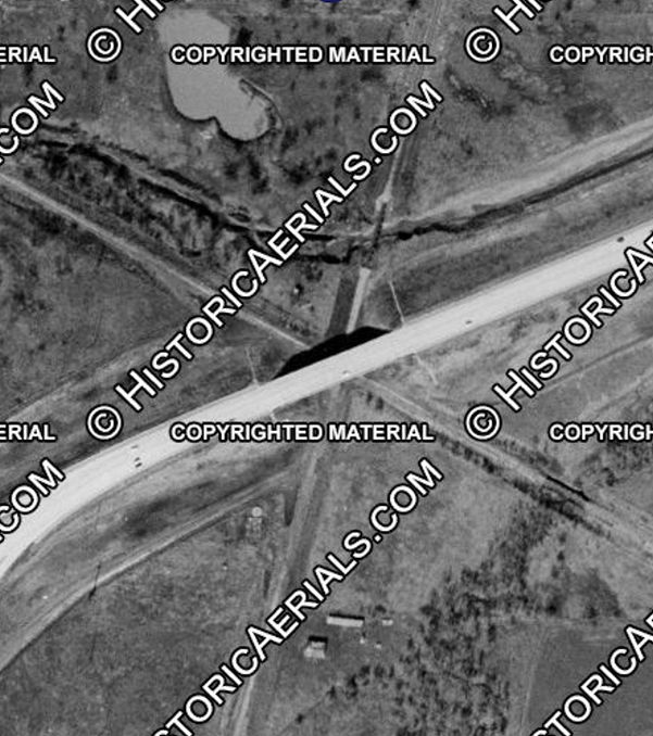
Below Right: This 1956 image
((c)historicaerials.com) shows that the Katy's Mineola branch used short bridges
over the L&A and Cotton Belt with a fill between them. The image also shows that
there was a connecting track that allowed movements between Mineola trains and
Hunt Yard. The short distance between the Hunt Yard lead and the main track to
Mineola, along with the relative angle of the two tracks, required the connector
to depart the Mineola branch from the fill south of the bridge over the L&A,
hence a second bridge over the L&A was required for the connecting track. The Mineola branch was abandoned
the same year this photo was taken.
The "Other" Crossings in Greenville
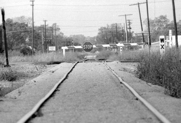
Above Left:
This photo was taken by Fred Frailey, Special Correspondent and Columnist for
Trains magazine, in 1978. It faces west at the
crossing of the KCS and Cotton Belt tracks and shows that the diamond was
protected by a swing gate. Whether unlatching the gate from its post triggered
any signals has not been determined. The dark, wooden post at far left is a side
view of a crossbuck; the diamond sat directly on Bois D'Arc Street, a
roadway that is not obvious in the photo. Note the WX posts commanding
whistles for upcoming grade
crossings. (photo courtesy Nathan Bailey)
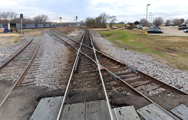
Above Right: This 2018 Google
Street View shows generally the same view of the KCS/Cotton Belt (NETEX)
crossing, now a substantially more acute angle due to a grade
relocation project. The entire area looks vastly different because the project included new bridges for Stonewall and Johnson Streets
which are visible in the distance. The large truck on the parking lot
in the background is approximately on the former KCS grade (note slight elevation in the grassy
area.) KCS rerouted the
track onto the Cotton Belt ROW to reduce grade crossings and to pass beneath the
new street bridges. Those bridges and the elimination of grade crossings at Mill
St. and Stuart St. resulted in retail business relocations (e.g. the Michelin tire store in the above left photo)
and other disruptions since there was no longer any traffic.
Ultimately, the abandoned area beneath and beside the bridges was reclaimed for
other uses. East of the bridges, part of the land was used for a new Hunt County Sheriffs Office
and Detention Facility (the parking lot with the truck.) On both sides of the bridges and
in between, a major landscape beautification project was undertaken. The
KCS/Cotton Belt diamond is now managed by an automatic interlocker.
Above: John W. Barriger III
took this photo, probably in the 1930s, from his business car as he faced
northeast along the Cotton Belt tracks in Greenville. Referencing the annotated
image below left, his business
car has just crossed the Texas Midland tracks (pink circle) where the white gate
is positioned against the TM. The crossing was not interlocked, but some kind of
building sits adjacent to the TM tracks. In the distance beyond the crossing, a
connecting track from the TM can be seen reaching the Cotton Belt tracks (at
uppermost green arrow) with an adjacent switch stand. This connection allowed
northbound TM trains to join the Cotton Belt heading northeast for the trip to
Commerce. The four switch stands on Barriger's side of the crossing indicate the
presence of Cotton Belt yard and/or spur tracks in this vicinity (i.e. near the
lowest red arrow.)
Above Left:
When the Texas Midland first built into Greenville, it continued northeast by
sharing the Cotton Belt (red arrows) track to Commerce (toward upper right direction,
track still intact) by curving onto it (green
arrows.) When TM built its own line to Commerce in 1923, it's main line (yellow
arrows) was extended across the Cotton Belt at an apparently uncontrolled
crossing (pink circle) and then curved toward Commerce to parallel the Cotton
Belt. Additional tracks
(yellow dashes) were built to provide a wye for the TM. When SP took over the TM
in 1933, the Cotton Belt connection was reinstituted and the TM
line to Commerce was abandoned. Despite the passage of 85 years, the path of the
TM main line curving toward Commerce remains discernable in this
2018 Google Earth image from east of downtown, north of Lee St. The TM was
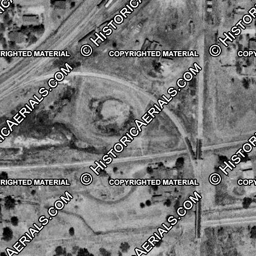
completely abandoned by 1958. Above Right:
This 1958 image shows the TM and Katy crossing
southeast of downtown Greenville. They formed an X-pattern that at least by 1958
had been covered by a US 67 highway bridge. Since the Mineola branch was
abandoned in 1956 and the TM in 1958, the subsequent reconstruction of US 67
into Interstate 30 eliminated the bridge. ((c)historicaerials.com)
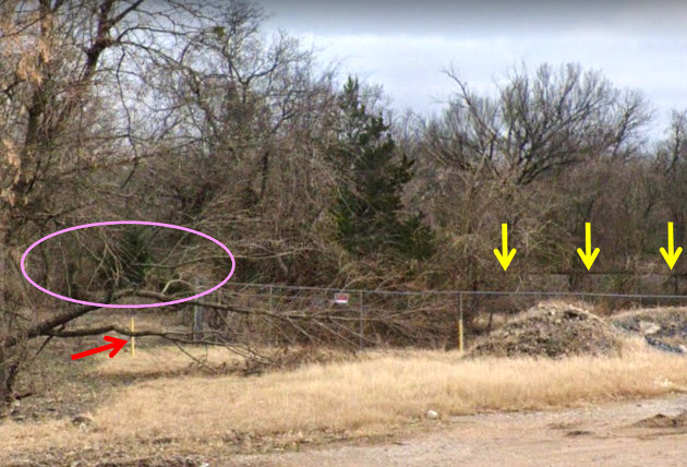
Below Left: This 2018 Google Street View is looking south from
Lee St. on the east side of Greenville. The red arrow points to a yellow stake
that (undoubtedly by accident) happens to sit in the middle of the Texas Midland
grade which runs north/south at this location. The yellow arrows point to the
visible KCS tracks at the back edge of the property. The pink oval shows that,
if not for the 60 years of elapsed time since the TM was abandoned, a crossing
diamond would likely be visible. This crossing was not part of RCT's numbered
interlocking system and was probably gated.
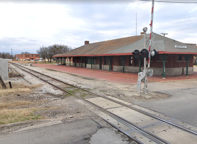
Below Right: The Katy depot still stands in Greenville. It was
added to the National Register of Historic Places in 1997.(Google Street View
2018)