Texas Railroad History - Tower 80 - Houston (Percival,
Belt Junction)
Crossing of the Houston Belt & Terminal
Railway and the
International & Great Northern Railroad
Photos from the John W Barriger III
National Railroad Library
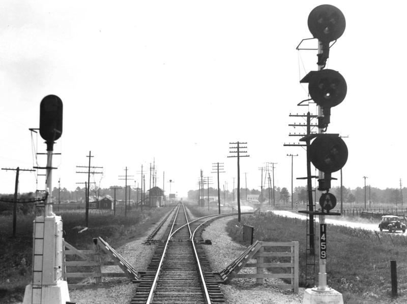
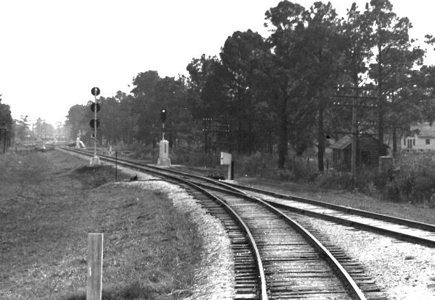
Above: John W. Barriger III
took this photo from the rear platform of his business car in the early 1940s,
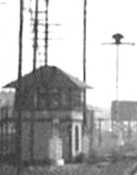
apparently having just spotted Tower 80 in the distance (magnified at
right.) His train had come
northbound onto the main line of the International & Great Northern (I-GN) Railroad
from the adjacent connecting track (note switch positioned
against the main track.) The signal post numerals show that Barriger was at
Milepost 145.9, one-tenth of a mile north of Tower 80's listed timetable location
of 146.0. (See purple arrow in the diagram below.)
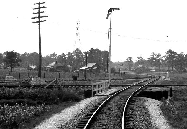
Below Left: Moments
earlier, Barriger's train had passed over the East Belt tracks of the Houston,
Belt & Terminal (HB&T) Railway. At that diamond (in the foreground), Barriger
had a closer view of Tower 80 a hundred yards to his left sitting in the
northeast quadrant of the East Belt's crossing of the I-GN. Visible in the far
distance is HB&T's North Belt which Barriger's train exited using Belt
Junction's east
connector. The switch visible beyond the diamond controlled whether northbound trains
merged eastbound onto the East Belt or continued north to cross the East Belt
and merge onto the I-GN, as Barriger's train was doing when he snapped this
photo. (See green arrow in the diagram below.)
Below Right: A few seconds beforehand, Barriger took
this photo just as his train cleared the switch off the North Belt onto the east connector.
The North Belt was the "Passenger Main", the primary route for I-GN and other
passenger trains departing Union Station to the north. The opposite route at the
switch was the west connector that curved westbound onto the
main line of the Burlington - Rock Island Railroad to Dallas. Barriger's
destination was Palestine, as evidenced by additional photos in this
sequence from the John W. Barriger III National Railroad Library. (See blue
arrow in the diagram below.)
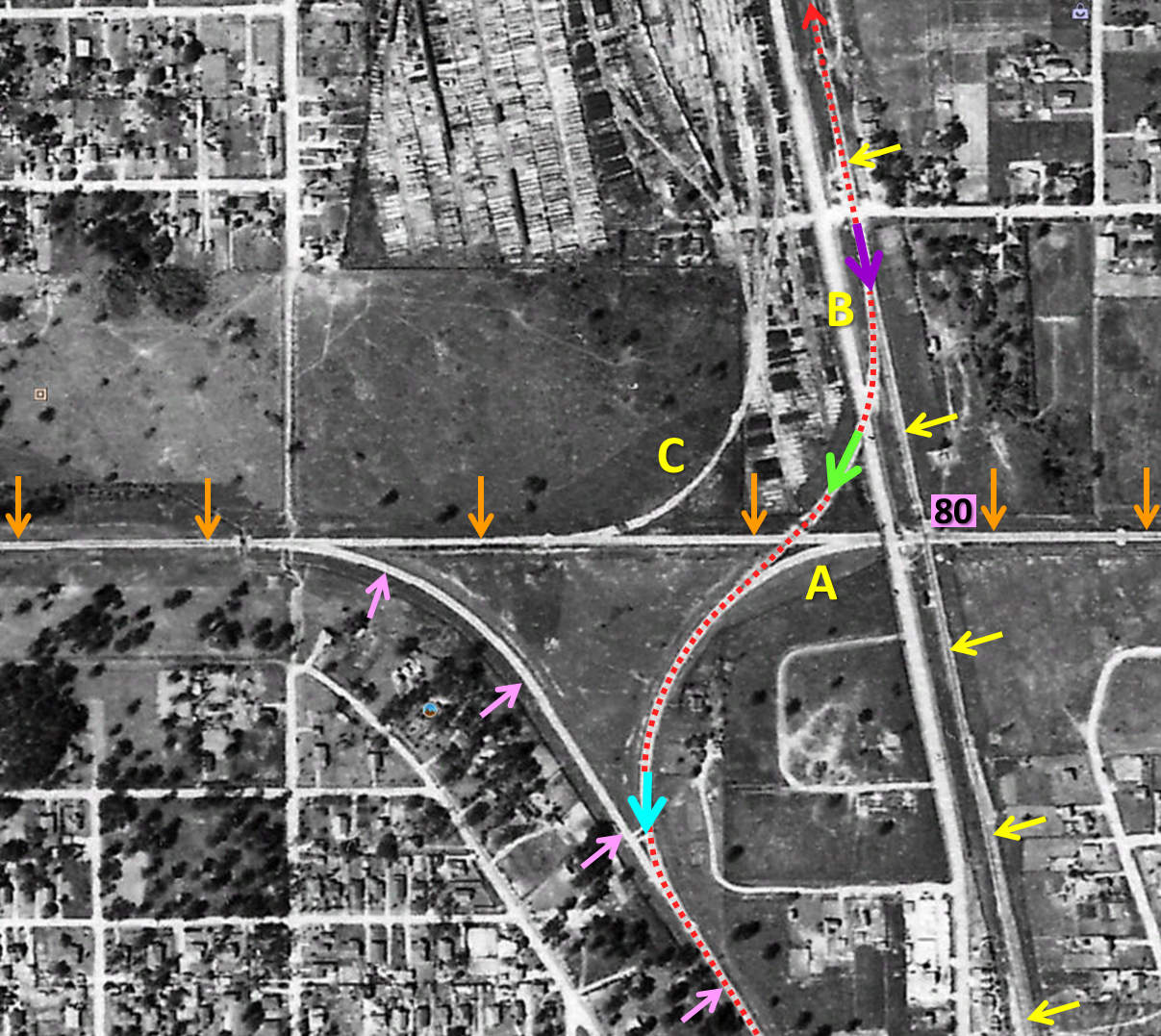
Above: Barriger was shooting south from the rear
platform as his train was moving north, from the bottom of the image to the top
along the dotted red line. His first photo (blue arrow) was taken where his
train left the North Belt (pink arrows) onto the east connector. He took the second photo (green arrow) shortly after his train
had taken the connecting track that crossed over the East Belt (orange arrows).
The switch visible in that photo is the continuation of the east connector ("A") that curved onto the East Belt near the tower. The last
photo (purple arrow) occurred immediately after coming onto the I-GN main line
(yellow arrows.) The car in that image ("B") is on Hardy Rd. immediately west of
the I-GN tracks. There was also a lead ("C") off the
East Belt into the Koppers creosote yard; the yard connected to the I-GN farther
north. This intersection of HB&T's East Belt and North Belt tracks was known as
Belt Junction. (1944 aerial image provided by the Texas General Land
Office and Google Earth)
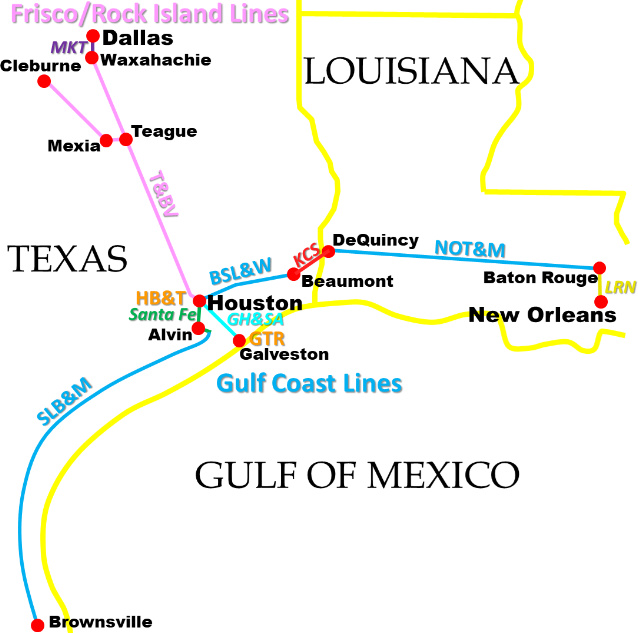
The Houston & Great Northern (H&GN) Railroad
commenced construction in 1871
with a plan to build from Houston to the Canadian border. By the end of
1873, the east
Texas town of Palestine was the northern extent of
the tracks, about 150 miles from Houston. The International Railroad also had
tracks in Palestine as part of its plan for a main line between Fulton, Arkansas and Mexico.
The International had begun construction at Hearne, roughly the mid-point of its
route, and by 1873 had built northeast to Longview via Palestine.
With their goals and their tracks connecting in Palestine, the H&GN and the International joined
forces to create the International & Great Northern (I-GN) Railroad. The I-GN expanded to become
one of the major railroads in Texas, but not without enduring several
bankruptcies.
Fifty years later, the I-GN was coming out of a lengthy receivership in excellent shape physically and financially.
By then (1922), it served numerous major Texas cities and towns, among them Houston,
Galveston,
Fort Worth, Longview, Waco,
Bryan/College Station, Austin,
San Antonio and Laredo, a vast swath of Texas
commerce. Its new owners tried to sell it to the St. Louis San Francisco
Railroad ("Frisco"), but the Interstate Commerce Commission (ICC) withheld
approval. This potential sale alarmed the Missouri Pacific (MP) Railroad; it
wanted the I-GN as its entry into the Texas market. To prevent the I-GN from
falling into unfriendly hands, MP orchestrated the I-GN's acquisition by
the New Orleans, Texas & Mexico (NOT&M) Railway. The NOT&M was a collection of
railroads known more commonly as the "Gulf Coast Lines" (GCL), originally part
of Frisco but independent after Frisco's receivership in 1913. With I-GN safely
added to the GCL portfolio, MP bought the GCL in 1925 with ICC's approval,
gaining the I-GN and the rest of the GCL railroads. Among these were two, the
Beaumont, Sour Lake & Western (BSL&W) and the St. Louis, Brownsville & Mexico
(SLB&M), that each owned 25% of the Houston Belt & Terminal (HB&T) Railway.
Thus, acquiring the GCL in 1925 instantly gave MP half ownership of the HB&T,
and full ownership of three railroads in Houston: I-GN, BSL&W and SLB&M.
The HB&T had been chartered by four railroads twenty years earlier, the other
two being the Gulf, Colorado & Santa Fe Railway ("Santa Fe") and the Trinity &
Brazos Valley (T&BV) Railway. HB&T's chartered purpose was to construct
a Union Station for passengers and build additional
tracks and yards to facilitate freight interchange around Houston. This was a
rather bold plan considering that, at this time (1905), three
of the four railroads did not have tracks in Houston! Those three were controlled by B. F.
Yoakum, a native Texan who was CEO of the Frisco, and earlier that year had become Chairman of the
Executive Committee of the Chicago, Rock Island and Pacific Railroad ("Rock
Island"). In those days, several years before its 1913 bankruptcy, Frisco owned the GCL.
The GCL had two railroads, the BSL&W
and the SLB&M, that were preparing to build into Houston. For logistical purposes (and
perhaps community credibility), HB&T needed an owner that was already
serving the city. Adding Santa Fe to the ownership group satisfied this need.
With Yoakum controlling a 75% stake, HB&T's real
purpose was to put track and facility infrastructure into Houston to become
the central hub of Yoakum's Texas railroad network.
What was in it for
Santa Fe? Yoakum had been an executive at Santa Fe a decade earlier, so he knew
them well. Santa Fe only had a branch line into Houston from Alvin, so it made
sense for them to join with Yoakum to compete in the Houston market against
Southern Pacific (SP), which already controlled four railroads in downtown
Houston. SP had a fifth railroad in downtown
Houston, but a lawsuit filed by the Railroad Commission of Texas (RCT)
successfully forced SP to divest the San Antonio & Aransas Pass (SA&AP) Railway
in 1904 (as explained for Tower 2.) SP Chairman E.
H. Harriman had
substantial enmity toward Yoakum, accusing him of using his personal
relationships with RCT commissioners to raise a legal issue more than a decade
after SP had acquired the SA&AP (and he was especially galled because Yoakum
had been the SA&AP's court-appointed Receiver at the time.) Yoakum's executive
career had started with SA&AP under the tutelage of its president Uriah Lott in
the mid 1880s. Lott regarded Yoakum so highly that he chose "Yoakum" as the name
of the south Texas town where SA&AP's shops were to be built. Yoakum returned
the favor in 1903 by naming Lott president of the SLB&M.
When the SLB&M's
northward construction from the Rio Grande Valley
finally reached the community of Algoa in 1906, it
connected with the Santa Fe. Yoakum was able to negotiate rights to use their
tracks to Virginia Point where he had arranged to
use the I-GN tracks into Galveston, which were actually
owned by the Galveston, Houston & Henderson (GH&H) Railroad and leased to I-GN. He tried to negotiate rights to reach Houston via
Santa Fe's branch line at Alvin which was less than five miles west of Algoa,
but Santa Fe did not agree initially. Yoakum wanted to avoid
the expense of building his own line into the city and he didn't
want to duplicate Santa Fe's route; he needed their help in other areas (e.g.
operating
the HB&T and access to Galveston from Houston.) Although the SLB&M rail line
was complete between Brownsville and
Algoa by March, 1906 (as evidenced by contemporary newspaper reports), there
were significant problems with the bridges and ballast across the Brazos River
drainage between Bay City and Algoa. The issues were so severe that it took more
than a year to make the grade worthy of regular service. Occasional special
trains made the trip between Bay City and Algoa, but regular service from
Brownsville all the way to Houston via Algoa and Alvin did not commence until December 31, 1907.
Yoakum's
final agreement with Santa Fe for use of the branch line at Alvin is dated April 1, 1908
and remains in place today for the successor railroads.
The fourth HB&T
owner, the T&BV, also did not serve Houston; it wasn't even
building in that direction! But it became Yoakum's solution to a basic problem
he faced -- he did not have a railroad that operated between north and south Texas. The Frisco and Rock Island both
served Dallas/Ft. Worth, but they had no connection to his GCL railroads in
south Texas. Instead, Yoakum's companies delivered freight to other railroads,
primarily SP, when transfers
between Dallas/Ft. Worth and Houston were required. Yoakum wanted to keep this lengthy freight haul (~ 250 miles) within his
empire, so his solution was to buy a small, central Texas railroad, the T&BV,
and revise its charter for construction of a Houston - Dallas main line. Yoakum arranged for the Colorado & Southern (C&S)
Railway (where he was on the Board of Directors) to buy the T&BV and then sell
half of it to Rock Island. When this occurred on August 1, 1905, the
T&BV had just 79 miles of track, from Cleburne to
Mexia (where it passed within a mile of Yoakum's
birthplace, the tiny settlement of Tehuacana.)
Planning far ahead in his
typical bold fashion, Yoakum negotiated trackage rights for the T&BV between
Houston and Galveston, but there are conflicting answers as to which railroad
provided the tracks. The dean of Texas rail historians, S. G. Reed, states that
it was the Galveston, Harrisburg & San Antonio (GH&SA) Railway that initially provided
rights. RCT's 1913 Annual Report states that T&BV had rights on 46 miles of
Santa Fe tracks between Houston and Galveston. The mostly likely answer is
"both", i.e. GH&SA provided the initial rights, and T&BV switched to Santa Fe
rights
later. Since the GH&SA was legally independent in 1905, but functionally
controlled by SP, it would not be a surprise to find that SP management leaned
on the GH&SA to dissolve the T&BV agreement at some later time, and thus,
T&BV struck a deal with Santa Fe. Whatever the case, Yoakum chartered the
Galveston Terminal Railway (GTR) on August 29, 1905
and assigned its ownership to the T&BV, positioning him to influence freight
hauls through the port of Galveston. Two days later, the HB&T was chartered in
Houston with T&BV as a 25% owner. He then negotiated rights for the T&BV to use
Santa Fe's line between Ft. Worth and Cleburne. Yoakum
finished his busy 1905 by signing a contract with the C&S wherein he agreed
to oversee
revisions to the T&BV's charter and manage construction of the new main line.
 |
Left: Houston was to be the "Grand Central
Station" of Yoakum's rail empire in Texas and Louisiana. After becoming
Chairman of the Frisco in 1897, Yoakum began planning a major expansion
using Frisco backing of a financial syndicate managed by the St. Louis
Trust Company. The syndicate would build or buy railroads collectively
into the Gulf Coast Lines (GCL). After the Rock Island came under Yoakum
control in 1905, it was used to support his acquisition of the T&BV to
serve as his connecting railroad between his Frisco and Rock Island
lines in north Texas and his GCL lines in south Texas.
The
syndicate chartered the SLB&M in 1903. Construction between Houston and
Brownsville commenced in 1904 starting at
Robstown. Service to Houston using Santa Fe rights from Algoa (near
Alvin) began in 1906. The BSL&W, owning only a 20-mile line from
Beaumont to
Grayburg, was acquired by the GCL in 1905. The GCL directed the
BSL&W to continue west from Grayburg to Houston, an extension
completed in 1908. Construction of the NOT&M commenced in 1905. Service
began in 1909 between DeQuincy and Anchorage (across the river from
Baton Rouge.) To avoid bridging the Mississippi River, Yoakum used a
ferry to reach Baton Rouge and trackage rights on the Louisiana Railway
& Navigation (LRN) Co. from there to New Orleans. Rights from
Beaumont to DeQuincy (via Mauriceville) on KCS
, and more critically, the use of KCS'
bridge over the Neches River in Beaumont,
gave the GCL a continuous line from Brownsville to New Orleans. Those
KCS rights remain in use today.
The T&BV was acquired in August,
1905. Construction to Teague was initiated in 1906, and from there, north
and south to Dallas and Houston, respectively. The main line was
completed in 1907. At Houston, HB&T construction began in 1906 or 1907,
with the North Belt finished in time for T&BV trains to use it. East
Belt construction met the BSL&W in 1908, and then continued around the
east side of Houston between 1910 and 1912. Besides the aforementioned
rights on other railroads, gaps were also filled by the Missouri-Kansas-Texas
[MKT] (Waxahachie to Dallas), the GH&SA (Houston to Galveston, where the Port of Galveston
was served by Yoakum's GTR), and the Santa Fe (Algoa to Alvin to
Houston, and, at least by 1913, Houston to Galveston). The T&BV also had Santa Fe trackage rights from Cleburne to
Ft. Worth (not depicted.)
Other Texas railroads in the GCL
portfolio prior to its acquisition by MP in 1925 included the
Orange & Northwestern, and the San Benito
and Rio Grande Valley. The Sugar Land Railway
near Houston was acquired by MP and assigned to the GCL in 1926. |
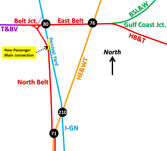
The newly chartered HB&T began planning to
build tracks in Houston. A line around the east side would serve the rapidly growing
industrial port along Buffalo Bayou east of downtown. This "East Belt", however,
was not nearly as important to Yoakum as construction of a line north from
downtown. The
T&BV and BSL&W would soon be arriving in Houston from the northwest (1907) and
northeast (1908), respectively, and Yoakum's priority was to build a
shared track, the "North Belt", so their trains could access the new
passenger station downtown and
continue farther south to HB&T's new yard. Santa Fe already had a spur (dating to 1896) that went north from
downtown to an interchange with the Houston East & West Texas (HE&WT) Railway
a mile north of Buffalo Bayou.
Starting there, HB&T built a half mile farther north and crossed the HE&WT, a
location that became interlocked as Tower 71. The North Belt
continued
two miles farther north where it ended, to await the arrival of the T&BV.
It is likely that HB&T curved the North Belt tracks to
the west and built an additional distance to meet the approaching T&BV.
Yoakum began T&BV construction in 1906, first
building 14 miles from Mexia east to the community of Brewer, which Yoakum
incorporated as Teague, his mother's maiden name. Teague
would become the T&BV's major yard between Dallas and Houston, and it
remains an important yard today. From
Teague, Yoakum built south, getting within 77 miles of Belt
Junction by the end of 1906. In 1907, Yoakum finished the main line
construction. He built north from Teague, stopping in Waxahachie
where
he was able to obtain rights to use the MKT tracks to cover the remaining distance
to Dallas. To the south, the T&BV entered Houston from the northwest and turned due east toward
Belt Junction where it met the HB&T to access the city. Service between
Dallas/Ft. Worth and Houston/Galveston began immediately over the new main line
which, due to its lower grades and fewer curves, was faster and less expensive
to operate than SP's competing route via Hearne. SP
retaliated by building a new line that literally paralleled T&BV's tracks for 42
miles (!), but that's another story...
The
BSL&W had also been bought by Yoakum in 1905 and had been assigned to the GCL. A year
earlier, the BSL&W had completed its only rail line, 20 miles from
Beaumont to
Grayburg, a settlement one mile south of the town of Sour Lake. The line's purpose
was to use Beaumont as the processing and shipping point for oil coming out of
the booming Sour Lake oil field, but Yoakum had other ideas for the BSL&W's
tracks; they already
covered a quarter of the distance from Beaumont to Houston, and he needed a
route east from Houston. At Beaumont, the
GCL negotiated trackage rights on the Kansas City Southern (KCS) to DeQuincy,
Louisiana, and from there, GCL was building its own NOT&M route to New
Orleans (which included a Mississippi River ferry at Baton Rouge and trackage
rights from there to New Orleans.) Completing the BSL&W's remaining
distance into Houston would eventually give Yoakum continuous service from
the Rio Grande Valley to Houston to New Orleans on the GCL, which was
accomplished by 1909.
To meet the BSL&W in
1908, a switch was added at the north end of the North Belt from which a track
curving to the east was built. This was essentially the northern terminus of what would
become the East Belt. Given HB&T's long range plans, it's likely that an
east/west "straight through" track was also built at this time. The resulting
triangle of tracks ultimately became known as Belt Junction. The track to the
east crossed both the I-GN, where Tower 80 would be installed, and the HE&WT, where
Tower 76 was commissioned in
late 1908. For the I-GN crossing, Tower 80 first appeared in RCT's tower list in
1910, but with no operational date. Tower 80 was finally approved on July 25,
1913 by RCT with a 14-function mechanical
interlocker. Since only 14 functions were required, it is likely that the Tower 80
interlocker controlled the HB&T/I-GN diamond and little else (the minimum
interlocker configuration for a simple crossing was generally twelve functions: four home signals,
four distant signals, and four derails.)
RCT's October 31, 1913 list of approved
interlockers identified Tower 80's location as "Houston", with no additional
detail. A 1915 report changed the location to "Percival". Later reports also
cite the location as "Houston, Percival" and "Percival (Houston)." This
reference is associated with I-GN's Percival Yard (originally "Percival Avenue
Yard", the street no longer exists) located immediately
south of Tower 80. Although Belt Junction and Tower 80 were synonymous in later
years, it did not begin that way; RCT's published lists never used Belt Junction as a reference
for Tower 80's location. The connotation of Belt Junction was the intersection
of the East Belt and North Belt which initially was very close to, but entirely west of,
Tower 80.
 |
Left:
At the north end of the North Belt, it's likely that the HB&T curved
west to connect with the approaching T&BV in late 1907. To meet the
arriving BSL&W in 1908, the north part of the East Belt was built across
both the I-GN (Tower 80) and the HE&WT (Tower 76). The Passenger Main
connecting track (pink) for I-GN trains that crossed at Belt Jct. (the
route Barriger took) was likely built when the US Railroad
Administration moved I-GN's passenger services to Union Station during
World War I. It was an expedient solution to get I-GN passenger trains
to/from Union Station, but had the negative impact of a second diamond a
hundred yards west of Tower 80. It wasn't used for freight; HB&T had a
better I-GN freight connection south of downtown which included a
connection with the GH&H.
In 1926, RCT's published list shows that Tower 80's functions suddenly
increased to 23. In 1925, MP had taken ownership of I-GN and become
half-owner of HB&T, so this likely reflected expanded interlocker
controls desired by MP. By 1951, I-GN's Passenger Main connection (pink)
was gone, replaced by a new connection (yellow) at Percival Yard. It is likely that
new connectors were added in the northeast and southeast quadrants at
Tower 80 at the same time. This would allow HB&T switchers and intercity
I-GN freight trains to reach MP's new Settegast
Yard which had opened by the end of 1951. The North Belt then became
exclusively the Passenger Main to Union Station (industries would still
be served by HB&T switchers.) Aerial imagery from
1944 shows very little activity at Percival Yard despite a large number
of tracks. It was likely abandoned soon thereafter in favor
of Settegast Yard, ensuring that the new Passenger Main connection would not
have interference from freight yard operations.
When East Belt construction
resumed southeast from the BSL&W connection c.1910, the result was Gulf Coast Jct.,
named for the GCL trains that used the BSL&W tracks.
The East Belt curved south and ultimately southwest forming a
semi-circular route around the eastern part of the city.
Towers 86 and
87 along this path were commissioned in April, 1911, followed by
Tower
85 in May, 1911. The south end of the East Belt terminated at HB&T's New
South Yard (Tower 117) south of downtown.
At MP's request, Tower
80 took over remote control of Tower 76's
interlocker in 1930. |
 |
 |
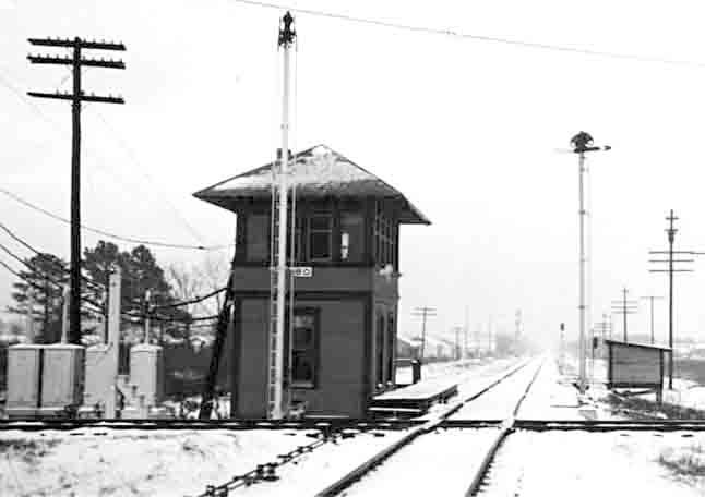
| Above:
Looking east at Tower 80 from Hardy Rd. in January, 1949 (courtesy, Greg Johnson) |
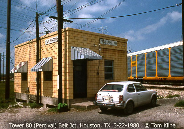
Above:
the newer Tower 80 building, March 1980 (courtesy, Tom Kline) |
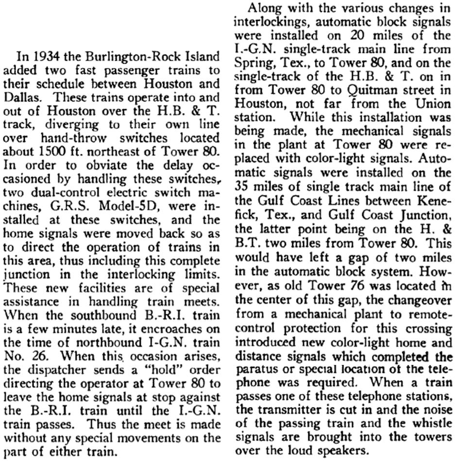 |
Left and Below: These excerpts are from an article in the
1935 edition of Railway Signaling and
Communications that was written by an MP signals engineer. The
article described the consolidation of interlockers that occurred in
north Houston beginning in 1928, and it explains why the controls for
Tower 76 were incorporated into Tower 80 rather than making Tower 76 an
automatic interlocker.
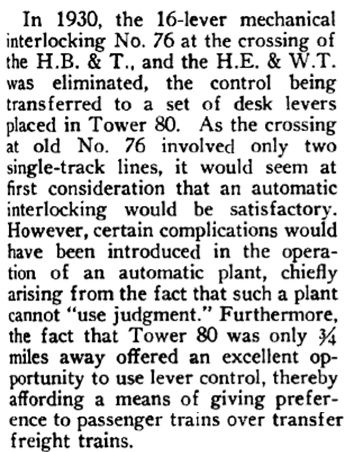 |
By 1914, Yoakum's takeover of the T&BV had proven to be
financially improvident. Outside of Houston and Dallas, neither the main line
nor the branch from Teague to Cleburne had much population, so there was little
local demand for freight or passenger service. And the few towns of even modest
size all had better rail alternatives: Mexia (SP), Hillsboro (MKT), Cleburne (Santa Fe), and
Corsicana (SP). This left the
T&BV almost entirely dependent on Houston - Dallas/Ft. Worth traffic which was insufficient since
SP, MP and Santa Fe also served the market. The T&BV went into bankruptcy, finally emerging in 1930 as a newly organized company, the Burlington - Rock Island
(B-RI) Railroad. The B-RI's ownership was split equally between Burlington,
which had bought the C&S in 1908, and Rock Island. Various shared operations and
management arrangements for the B-RI were used over the decades to the benefit of
both owners. Ultimately, the main line became part of Burlington Northern Santa
Fe (BNSF), which continues to operate it today (the Teague - Cleburne branch was
abandoned in stages between 1932 and 1976.)
Did the T&BV build
all the way to Belt Junction in 1907, or did it meet HB&T somewhere west of Belt Junction?
If it was west of Belt Jct., there might have been historical
switching rights resulting from the actual meeting point of the T&BV and the
HB&T. Tom Kline reports that a 1973
Rock Island track chart in his collection shows the B-RI ending 3.4 miles west
of Tower 80 at B-RI milepost 60.65, with the remaining distance to Tower 80
marked as "HB&T". Tom explains:
"Operationally
speaking, the tower was where the terminal began and ended for the B-RI. ... As
to a distinct line of demarcation to where the T&BV stopped, it was always
referred to generally as North Shepherd Drive by the B-RI guys. On the days I
did work on the North Houston Switcher out of the North Houston Yard at West
Little York Road, they [B-RI] never worked any customer farther south than Oak
Forrest Drive. There were several spurs between Shepherd and Yale Streets
feeding local shippers and HB&T served them so I guess those were historical
switching rights."
At least in recent times, there do not appear to have
been any spurs between Oak Forrest Dr. and North Shepherd Dr., a distance of ~
1.5 miles. So, if the switching rights related to the original construction, the
T&BV and the HB&T would have met somewhere in this vicinity, with North Shepherd
Dr. being about 3.5 miles west of Belt Junction, consistent with the 3.4 mile
distance on Tom's Rock Island track chart.
 |
Left: This
aerial image from 1953 ((c) historicaerials.com) shows two new
tracks added to the junction after 1944: a double track in the NE
quadrant and a single track in the SE quadrant. The original tower is not apparent and
was probably gone. Belt Jct. operations had been moved to a new Tower 80
(red circle) located north of the East Belt tracks, about 125 yards east
of the I-GN/HB&T diamond (green circle). This new building is shown in
Tom Kline's photo above. Personnel reached it on a dirt road (light
blue arrow) that came from a residential street to the south. Tom discusses the new tower building...
"...the location was referred to as 'Tower NX' at one time...a holdover from the telegraph days. NX was the call sign of
the
interlocker. We never called it that but some of the old heads did. The
tower was razed in 1985, and video cameras were put in at
the east switch of the
plant to OS and record car numbers of passing trains."
The
lead into the Koppers creosote yard remained intact in 1953, as it did until the
site was abandoned in the 1980s. Across from it, coming off the east
connector to the East Belt, a remnant of the grade of the original
Passenger Main connector for I-GN (that Barriger used) is visible (yellow). That
connector (and its diamond with the East Belt) had been removed when the
new Passenger Main connector at Percival Yard was installed, at least by
1951 and probably earlier. The Belt Jct. east connector was still intact
even though it had been rendered obsolete by the new SE connector. The
Belt Jct. west connector was still needed for B-RI passenger trains.
In the late 50s or early 60s, a new SW connector was installed
closer to the diamond, and the east and west Belt Jct. connectors were
removed, the last of the original Belt Jct. connecting tracks. This
freed up most of the original Belt Jct. real estate as the junction was
effectively merged into Tower 80. The new SW connector preserved B-RI
access to the Passenger Main and was substantially closer to the new
tower.
|
MP had opened Settegast Yard at least by the end of
1951 to be its primary Houston freight yard. It was located four miles east of
Tower 80, sitting between MP's ex-BSL&W tracks and the East Belt. Intercity MP
trains using the I-GN tracks would take the northeast connector behind the new
Tower 80 building when accessing Settegast Yard. The southeast connector would
facilitate access by HB&T switchers serving industries along the I-GN line. An
HB&T map from 1974 labels the former I-GN line south of Belt Junction through
Tower 210, Tower 26
and the I-GN bridge over Buffalo Bayou as the "Freight Subdivision", distinguished
from the North Belt Subdivision via Towers 71, 26
and 139.
In the late 50s or early 60s, the
original east and west connectors at Belt Jct. were removed. The east connector
had been obsoleted several years earlier by the southeast connector, but the
west connector was still in use for B-RI passenger trains. It was replaced by a
new southwest quadrant connector so B-RI passenger trains could retain Passenger
Main access. The abandonment freed up significant real estate and allowed removal of the
west connector switch from
the Passenger Main near the former Percival Yard. The new southwest connector was also much closer to the
new Tower 80. The Hardy Toll Rd. was built in the mid 1980s along the former
I-GN right-of-way (ROW) south of Spring. Part of the former west connector ROW
was used to allow the road to swing west to avoid passing directly over Belt
Jct./Tower 80.
Tom Kline recalls Tower 80 operations from the early
1980s:
The southeast connector was used by trains off the I-GN Freight Main, usually
stuff coming out of downtown (Congress Yard, off the GH&H from Galveston,
transfers, etc.) or traffic going into downtown, but it never saw the frequency
of movements that the dual connectors did on the northeast quadrant. A few
trains would roll straight north or south on the old I-GN Palestine Sub, but not
many as I remember. The MP’s main artery was the east-west line to Settegast,
then diverting onto the Palestine Sub which seemed to get all the traffic.
Tom reports that Tower 80 records show 18 passenger
trains per day in 1952; some undetermined number of these were B-RI trains using
the southwest connector. With the demise of passenger trains when Amtrak was
created in 1971, the southwest connector became virtually abandoned. It now
appears to have been rejuvenated somewhat, most likely as a result of a
restructuring of HB&T's north/south traffic flow. In the early 1990s, HB&T's
former North Belt (Passenger Main) between Tower 71 and Belt Jct. was abandoned,
replaced by a double track routed from Tower 71 to Tower 210 and then back onto
the original I-GN ROW to Tower 80.
The southwest connector off the HB&T‘s B-RI connecting western line was for
passenger trains to get to Union Station. I remember it being in place but
darned near abandoned and never used. There was another leg [the east
connector at Belt Jct.] off this connector going back to the HB&T to form a
wye (which was pulled up after passenger service) and I recall one of the old
B-RI guys telling me they wyed passenger trains there at Tower 80 and backed
into Union Station. Not sure if that was Std. Operating Procedure or occasional.
I’m not sure what the last train was to use the Passenger Main to
Union Station since, just before Amtrak, the only passenger trains running were
the ATSF and SP on (mostly) their own tracks. ... Currently for Amtrak’s
operation of the Sunset Ltd., all trains use the Sunset Route to the west of
Houston and depending on traffic levels use either the BSL&W route east or the
old SP Sunset Route to Beaumont. Right now it seems the BSL&W sees the most
trains in both directions but it varies. The BNSF and KCS use the ex-SP line to
Beaumont the most in both directions while UP favors the BSL&W for through
movements, but it all depends on congestion in and between the two terminals.
I-GN continued to operate under its own name and it
subsequently incurred yet another lengthy receivership (as did other components
of MP's system.) When the bankruptcy finally settled, MP was reorganized and the
I-GN was merged into it in 1956. From the early 1980s through the 1990s, there
were substantial ownership, track and roadway changes that affected Belt Jct.
Union Pacific (UP) took over MP, becoming a half-owner of HB&T. The other half
owner is Burlington Northern Santa Fe (BNSF), successor to Santa Fe and
Burlington Northern, each of which owned 25%.
Additional Photos by Tom Kline
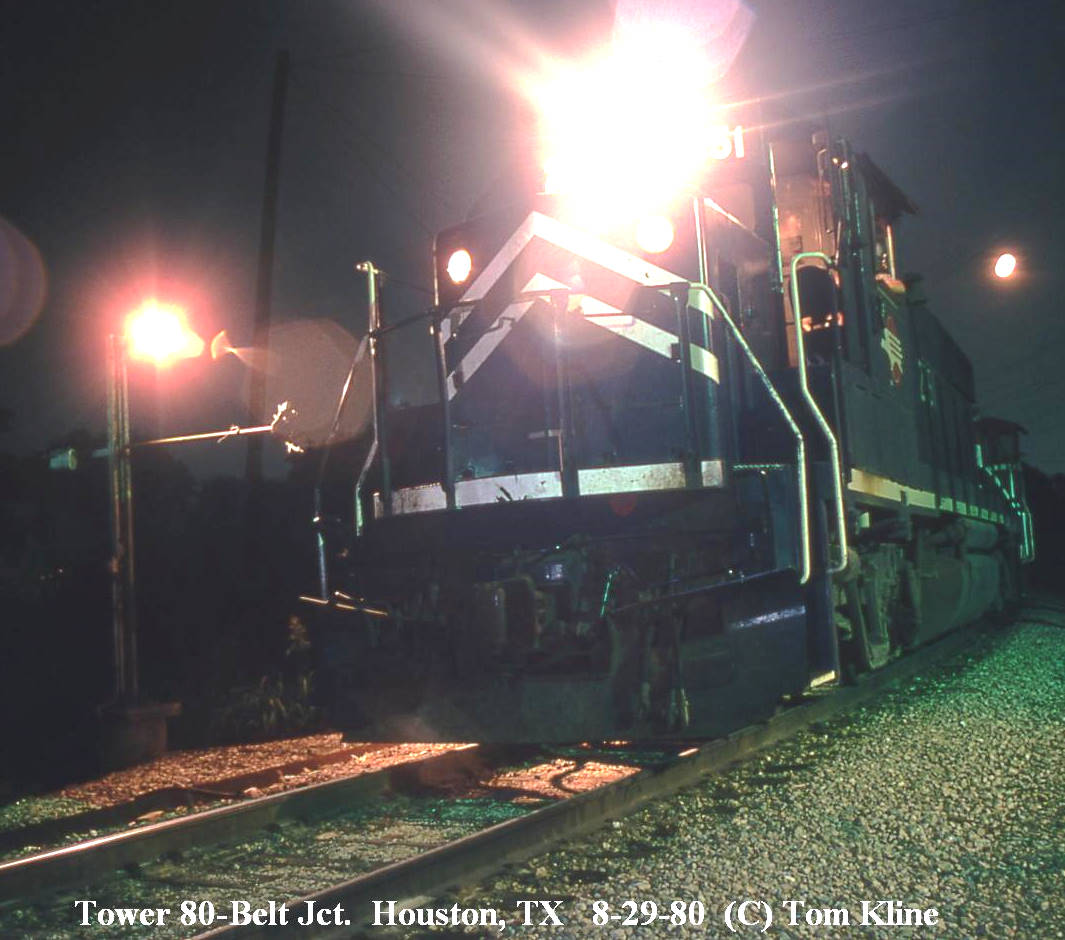 |
Tom writes: "A northbound MP freight waits for
a clearance card to be written up at the TO office on one of the
connector tracks in the northeast quadrant of the junction leading to
the Palestine Sub. Notice this connector is double track.
Also notice the homemade order stand under the floodlight on the
engineer's side of the loco. There were three of these in this
area next to the office. They could hold a total of four train
order forks each." |
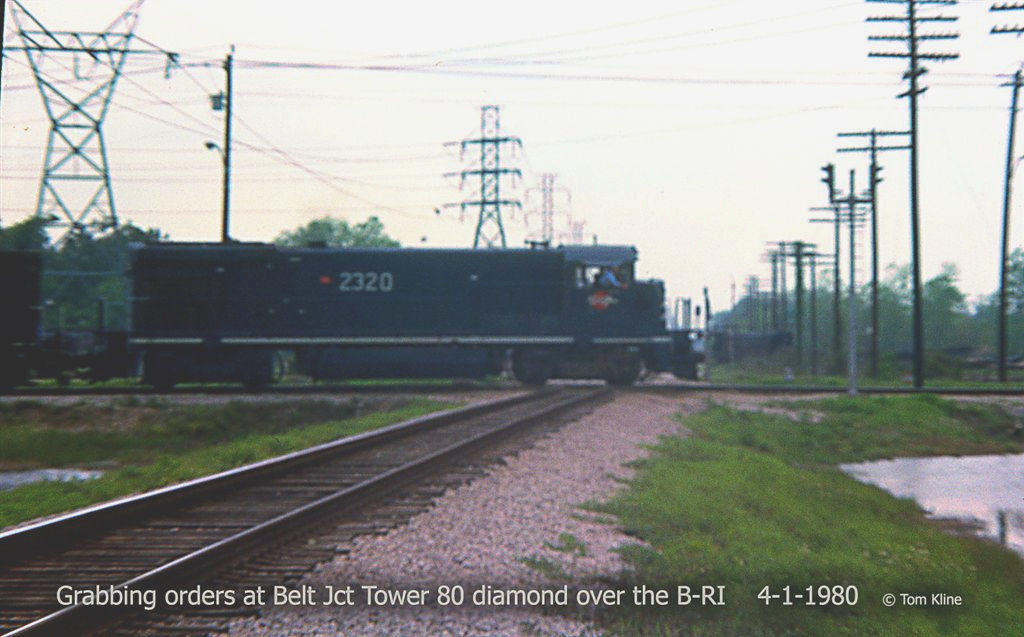 |
Tom writes: "A horribly blurry shot looking west from the train order office
down the HB&T/B-RI main of a MP freight grabbing orders while headed north off
the "Passenger Main" - now the West Belt - and onto the Palestine Sub. This is
a short telephoto shot and as you can see, the office was a good ways away from
the diamond. I ran down to hang these orders and shot this view out the
west window of the office. Notice the train order signal by the diamond for the
north-south main. In the distance is a bulkhead flat car sitting on the
lead into the Koppers creosote plant which occupied the northwest corner of the
crossing."
|
 |
Tom writes: "That's me handing up wheel reports
to the conductor of a Teague-bound train on the B-RI passing the Tower
80 office. Notice the connector track in the background, occupying the
southeast quadrant of the plant." |
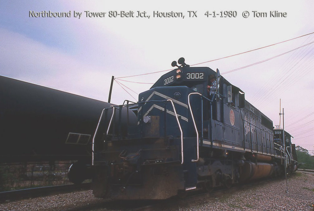 |
Tom writes: "On the inside of the two connector
tracks to the Palestine Sub a northbound eases past after grabbing
orders. Notice the High-Speeder order post to the right which replaced
the home made stand seen in the night photo above." |
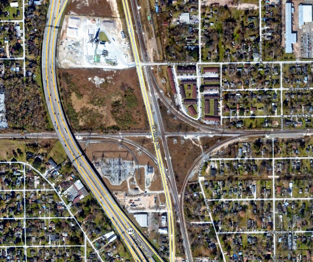
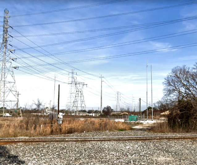
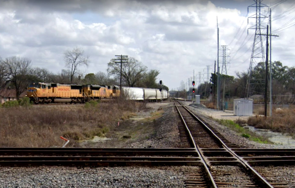
Above Left: 2018 satellite
image of Belt Jct. Above
Right: This 2019 Google Street View looks up the dirt road that
led to the brick building at Belt Jct. The building was across the tracks from
the green cabinet. Below: 2019
elevated Google Street View east toward Belt Jct. from the Hardy Toll Rd.

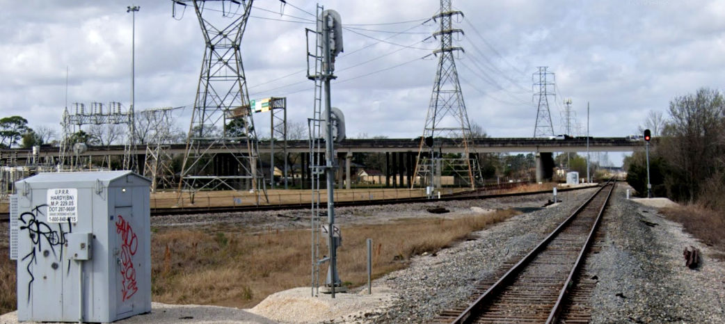
Two 2019 views from the Hardy Rd. grade crossing at Belt Jct.: west (above)
and east (below) (Google
Street View)