Texas Railroad History - Tower 89 and Tower 139
- Houston
Crossings of the Galveston,
Harrisburg & San Antonio Railway with the International & Great Northern and the Gulf, Colorado & Santa Fe railroads
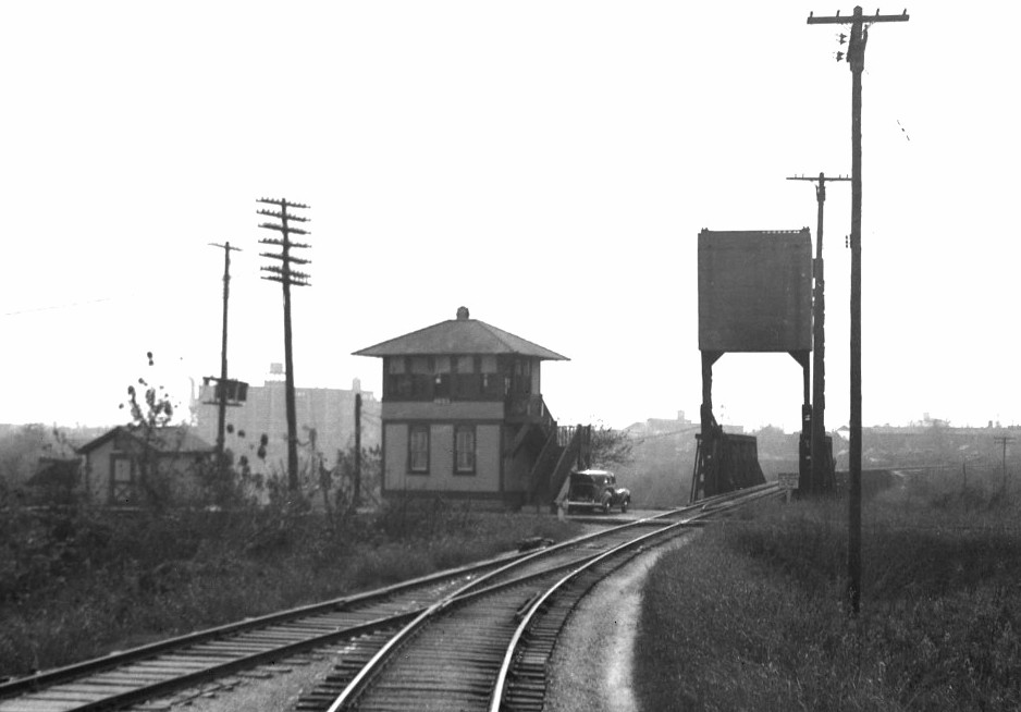 |
Left: John W.
Barriger III took this photo of the north face of Tower 139 from the
rear platform of his business car as he was leaving Houston, probably in
the late 1930s or early 1940s. His International - Great Northern (I-GN) train is
northbound on the Houston, Belt & Terminal (HB&T) North Belt, having
just departed Union Station. The
counterweight of HB&T's draw bridge over Buffalo Bayou is raised indicating that the bridge is down
and the track is in place, which Barriger's train has just passed over.
From this view, former tracks of the Galveston, Harrisburg & San
Antonio Railway inherited by
the Texas & New Orleans Railroad pass in front of Tower 139, crossing the HB&T
at a right angle near the bridge.
Although the
track to Barriger's immediate left merges onto the I-GN main line about 100
yards to the east, that route was used primarily for freight.
Barriger's train is remaining on the North Belt curving slightly to resume a due
north heading.
Barriger will soon pass Tower 26
and Tower 71 as he proceeds
to Tower 80. There, his train will transition to
the I-GN main line for his trip to Palestine
(as evidenced by
subsequent photos in this sequence from the John W. Barriger III National Railroad Library.)
A document in the
archives of the Railroad Commission of Texas at DeGolyer Library, Southern Methodist
University explains that Tower 139 was built as a replacement for the mysterious Tower 89. |
Tower 139 in Houston is the conclusion of a mystery
story that begins in 1912 when Tower 89 first appeared in the list of
authorized interlockers published by the Railroad Commission of Texas (RCT.) In
a table dated October 31, 1912, Tower 89 is identified as a 12-function
mechanical interlocker serving a junction of the Gulf, Colorado & Santa Fe
(GC&SF, "Santa Fe") Railway and the Galveston, Harrisburg & San Antonio (GH&SA) Railway in
Houston. Although no operational date was listed, this was not uncommon.
Sometimes a tower was scheduled for a final RCT inspection, but was not yet
commissioned at the time the report was printed (for example, Tower 90
in the same report.) In the next two annual reports, tables dated October 31 for
the years 1913 and 1914 continued to list Tower 89 with no operational date.
Beginning with a table dated October 31, 1915, Tower 89 was completely omitted
from the list. It reappears in a list dated
December 31, 1919, but only in a footnote identifying interlockers that have been "Abandoned on account of
removal of crossing". Tower 89's commissioning date is reported
vaguely as "1912" whereas the other abandoned towers have
precise commissioning dates. Tower 89 continued to be described this way through RCT's final
tower list published at the end of 1930.
So...where was Tower 89 and what happened to it? There
were only two Santa Fe / GH&SA crossings in Houston. One was at Tower 81
on the south side of Houston. The other was immediately north of Santa Fe's bridge over Buffalo Bayou near
downtown. In 1912, the GH&SA was a major
component of Southern Pacific (SP) and it had not yet been
merged into the Texas & New Orleans (T&NO) Railroad (which
would become SP's primary operating
company for Texas and Louisiana lines in the late 1920s.) One of the GH&SA tracks was
an east / west line built in 1876 along the north bank of Buffalo Bayou that ran
westward from Clinton to downtown Houston, a
distance of eight miles. Nearing downtown, this track crossed an original main
line of the
International & Great Northern (I&GN) Railroad (after 1922, known
as the International - Great Northern Railroad, "I-GN".)
A hundred yards farther, the GH&SA crossed the Santa Fe at the future site of
Tower 139 and then continued west, merging into other SP rail lines to reach
Grand Central Station, SP's passenger depot.
The Santa
Fe track crossed by the GH&SA was a spur
built sometime prior to 1890 to provide a connection from Santa Fe's
South Yard to an SP yard north of
Buffalo Bayou. Around 1907, Santa Fe transferred
operation of this spur to the Houston, Belt & Terminal (HB&T) Railway. HB&T
had been created in 1905 by four railroads, one of them Santa Fe, to provide
switching services around Houston. Apparently, the operating agreement included
HB&T funding a replacement for Santa Fe's bridge over Buffalo Bayou. This was accomplished
in 1912 with
construction of a new single-leaf steel bascule draw bridge (a design chosen
because Buffalo Bayou was navigable for another mile upstream to Allen's Landing
near Tower 108.) The spur remained under Santa Fe
ownership, and accordingly, Santa Fe was listed as one of the railroads that
crossed at Tower 89. While it certainly appears that the GH&SA / HB&T crossing at the north end of the bridge was Tower 89's
location, the letter below dated July 29, 1929,
seventeen years later, shows that neither RCT nor SP knew
for sure where Tower 89 was located nor what happened to it!
 |
Left:
This letter from T&NO's Signal Engineer, R. W. Meek, to RCT's Chief
Engineer, L. A. Gueringer, is the only item in the Tower 89 file at DeGolyer Library.
Meek asserts that Tower 89 was supposed to be "at
Maury Street", a north / south street on the north side of Buffalo
Bayou, but the "Plant was never constructed." Does this mean a
tower or other structure was erected but its interlocking plant was
never ordered from the manufacturer? Or does "Plant" refer to
the whole project, i.e. neither the interlocking plant nor the building
to house it was ever built?
There was a Maury Street location that
became interlocked as
Tower 207 in 1956, but it was at least a half mile from where Tower 139 was built. This was
not the Maury Street location Meek was referencing.
Meek asserts that "Buffalo Bayou, Tower
139 was placed in service at this location." This is confusing because
"...this location..." refers back to "...at Maury Street...",
but Tower 139 was a thousand feet east of Maury Street (and closer to at least
three other streets.) It is possible that "...this
location..." meant the functional location, i.e. the place
controlling the same set of switches and signals that Tower 89 would
have managed. Under this interpretation, Tower 139 was doing essentially
the same job for which Tower 89 was planned, but it was built at
a slightly different location. The ability for interlocking plants to control
signals and switches remotely over significant distances, even using 1912
technology, factored into tower location decisions.
Meek was based in
Houston and was responsible for
sending interlocking reports to RCT, hence he was
surely
familiar with the design and operation of
Tower 139, which opened seven months before he wrote his letter. Thus,
Meek's reference to "Buffalo Bayou, Tower 139" tends
to confirm the identity of the tower in Barriger's photo which obviously
sat on the north bank of the bayou (the tower number
placard in the photo is three digits, but they are illegible.) The style
of the tower indicates it was an SP design used by numerous other SP towers in Texas (e.g.
Tower 21, Tower 95,
Tower 100.)
Meek's reference to
Tower 89's location "...this plant was at Maury Street, crossing of T&NO, I-GN and
GC&SF" could imply that something actually was built at a
Maury St. site. If so, it was not near the eventual site chosen for Tower 139. |
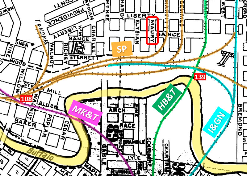
Right:
This image from the 1907 Sanborn Fire Insurance index map of Houston has been
annotated to show the rail lines on the north bank of Buffalo Bayou and
the site that eventually hosted Tower 139. Orange lines are various SP
railroads, blue lines are the I&GN, the purple line is the Missouri,
Kansas & Texas (MK&T, "Katy") and the green line is the H&BT operating
the original Santa Fe spur to the north. Maury St. is highlighted in the
red rectangle. Tower 108 controlled a Katy
/ SP crossing west of Tower 139.
Surely Meek's reference to the Tower 89 site as "Maury Street" and his assertion that
"...Tower
139 was placed in service at this location." (three
streets and a thousand feet away) cannot both be correct? But... notice that if Meek had
penned "Mary Street" instead of "Maury Street", only one letter different, his description would be correct. Mary Street was the right-of-way Santa Fe used north of Buffalo
Bayou and it was the street closest to where Tower 139 was ultimately built. Perhaps
Meek's typist, being familiar with "Maury Street" (which ran beside a
major SP yard farther north) but unfamiliar with "Mary Street",
misread Meek's handwriting? |
 |
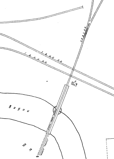 |
Left and Right:
1924 Sanborn Fire Insurance Map of Houston
Notwithstanding
Meek's identification of the location as Maury Street, might there have been a structure to house the Tower 89 interlocking plant
that was, in fact, built at the future Tower 139 site? Indeed, four years before
Tower 139 opened, the 1924 Sanborn Fire Insurance Map of Houston shows a structure
there. Under magnification, the structure
is revealed as a two-story "OFF." (office) with a door on the
east end and an 'A' indicating "Auto House", i.e.
a garage. The proximity to rails and the bridge indicates a
railroad purpose, perhaps a temporary residence for bridge tenders while
they raise and lower the bridge on a 24 / 7 basis. This could explain an upstairs
break area and a
garage. Or maybe the downstairs was the garage
and all operations were conducted from the second floor, as would be the
case if the railroads planned to install an interlocker. If this
building was for a tower, something derailed the plan; there's no garage
apparent in Barriger's photo nor have any been found incorporated into
interlocking towers.
Sheer speculation: If the facility was
used by bridge tenders, SP would not want the
incremental cost of managing HB&T's bridge incorporated into the tower's shared
expenses; SP had its own bridges over Buffalo Bayou. Operational costs for the
bridge would be borne
entirely by HB&T if no interlocker was present. Furthermore, HB&T needed the
interlocker much more than SP. HB&T's North Belt had become a busy main track
whereas the GH&SA line was a secondary route, with trains unlikely to be moving at speed.
The delay of stopping at a non-interlocked crossing was
insignificant. SP might simply have backed out of the deal. Apparently, there
was no pending RCT order mandating an interlocker. |
 |
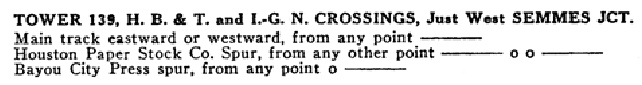
Tower 139 first appears in RCT annual reports in 1929 as a 36-function
electric interlocker that opened on December 20, 1928
involving HB&T, T&NO and I-GN.
By the time of Barriger's photo, it appears
that only a single track was crossing the HB&T at this junction. RCT files state that
in 1940, Tower 139 took over
the controls for Tower 5 which was about a mile to
the east. Whistle codes for Tower 139 are listed in a 1942 T&NO timetable, but
its continuation as a manned tower beyond the date is undetermined.
|
Right: These whistle
codes for Tower 139 appear in a 1942 T&NO Employee Timetable. Its
proximity to the HB&T bridge may suggest an elevated importance for
Tower 139, but it had relatively few spurs and side tracks to control,
and it does not appear to have survived into the 1950s. Unlike nearby
towers 26, 108 and 86, it is not listed in a table of whistle codes in a
1951 T&NO Special Instruction issued for Houston. |
 |
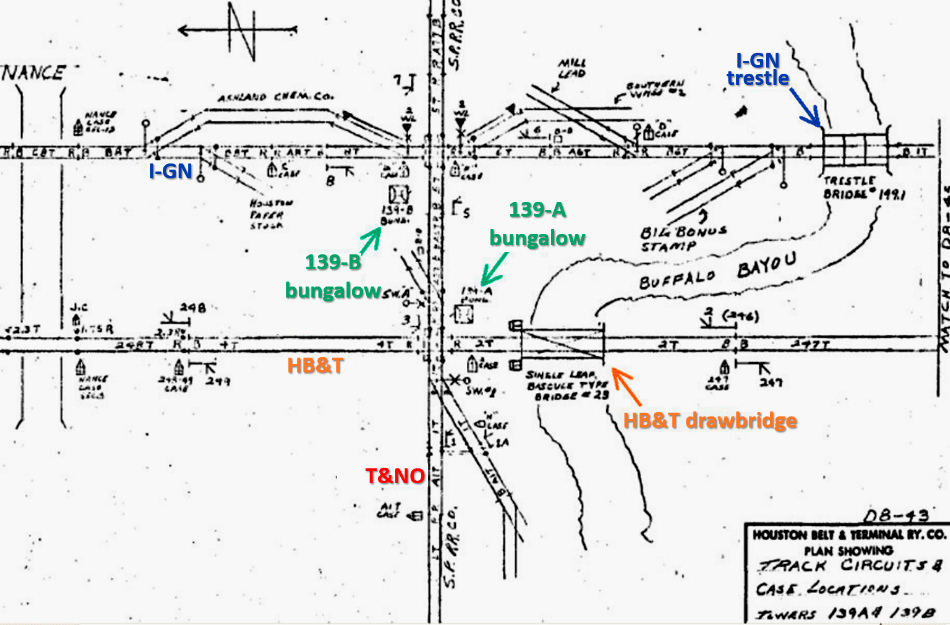 |
Left: With north to the
left, HB&T's 1974 track chart for Tower 139 (interlockers 139-A and 139-B)
shows the location of the equipment bungalows that replaced the original tower.
(track chart courtesy Neil Mackay) |


Above Left: This image is an excerpt from an undated photo in the Texas Dept. of
Transportation
archives. The photo is probably from late 1960 or early 1961 based on the
freeway construction
in progress. The Tower 139 "bungalow" (as referenced on HB&T track charts)
appears to be
visible near the crossing. Above Right: A similar photo taken at the same time but facing northeast
shows the Tower
139 "bungalow" structure more
clearly. Below Left: From the
same TxDOT photo archive, this image shows the 139-B bungalow as a traditional
cabin interlocker near the utility pole to the left of the diamond. This was a
crossing of the T&NO and the former I-GN, which had been dissolved into its
parent company Missouri Pacific (MP) in 1956; MP had acquired the I-GN as a
subsidiary in 1925. This crossing was
on the north bank of Buffalo Bayou immediately east of the bridge.
Below Right:
The nearly 100 year old HB&T steel bascule bridge remains intact across Buffalo
Bayou, hidden from the public by the maze of freeways crossing overhead, but
available for pedestrian use. The
original Tower 139 was probably located in the foreground of this photo. There
was no evidence of a foundation or structure apparent at the site. Note the
minimal clearance between the top of the rotation arm for the bridge and the
freeway overhead. Clearance issues required the massive counterweight structure
to be dismantled. (Jim King photo, 2006)


 |
Left: Rather
than discard the counterweight, it was preserved in the early 1990s on a new concrete
foundation surrounded by a barbed-wire fence near the bridge. Thanks to John Davis (pictured) for providing transportation to
this
and other tower sites in the Houston area! (Jim King photo, 2006)
Below: defaced historical plaque for HB&T's bridge
 |
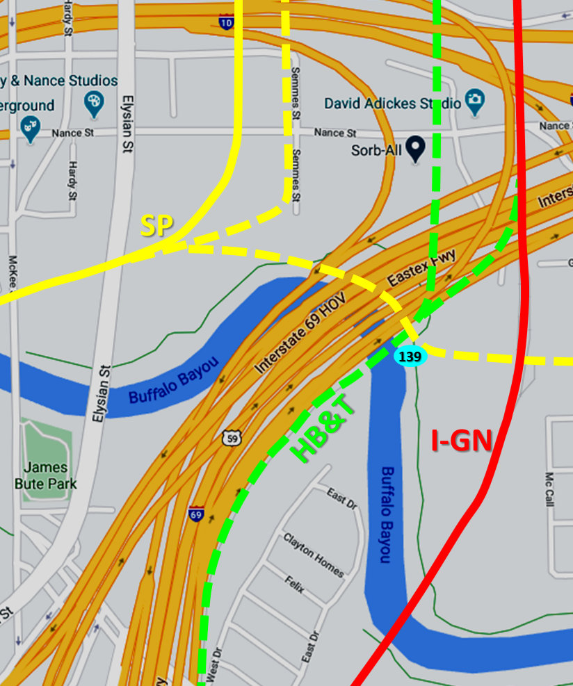
Right: The historical rail routes near downtown
Houston are mapped onto a current freeway map (Google Maps.) By 1968, HB&T had taken over
MP's former I-GN tracks and named it the Freight Subdivision (later, "East Main".) The former Santa Fe
tracks past the Tower 139 site remained HB&T's North Belt Subdivision (later, "West Main".)
In 1988, a major track relocation project
abandoned HB&T's West Main track on Mary St. to be replaced by a combined
double-track on the East Main and a new double-track bridge over Buffalo Bayou.
Farther north at Tower 26, the new double track curved back to the west
to rejoin the West Main continuing north. In essence, the new
double-track bridge over Buffalo Bayou replaced both the old I-GN
single-track bridge and the HB&T bascule bridge.
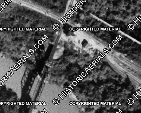
Below: Casting a large
shadow that almost reached the diamond, Tower 139 was still intact when
this aerial image ((c) historicaerials.com) was captured in 1947. The
date of the tower's final demise is undetermined.
 |
 |