Texas Railroad History - Tower
68 and Tower 87 - Houston (Englewood Yard)
Two Towers at Southern Pacific's Englewood Yard
 |
Left:
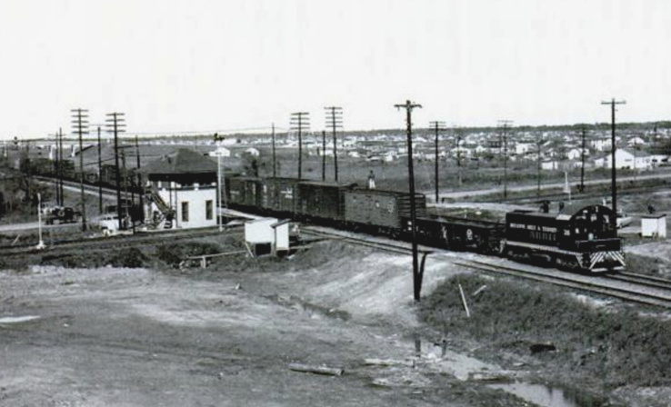
It was probably in the late 1930s or early 1940s when railroad executive John W. Barriger III took this photo of Tower 87 from
the rear platform of his business car. His train was going east out of
Englewood Yard, a major switching facility owned by Southern Pacific
(SP) northeast of downtown Houston. Barriger was facing west into the
yard; note the strings of railcars visible in the distance to the left
of the tracks. The tower sat northwest
of SP's diamond with the Houston, Belt & Terminal Railway.
Barriger's train
had originated
at SP's Grand Central Station and passed Tower 108
to join the main line at
Tower 26. From there, his car has traveled
~ 4 miles east, passing Tower 68 en route. Tower 68 was an important control
center for Englewood operations. |
 |
Left: This view of Tower 68 (Daniel Walford
photo, undated) shows a Union Pacific (UP) herald at the top. That dates
the photo to sometime after UP acquired SP in a 1996 merger.
Right: This photo of
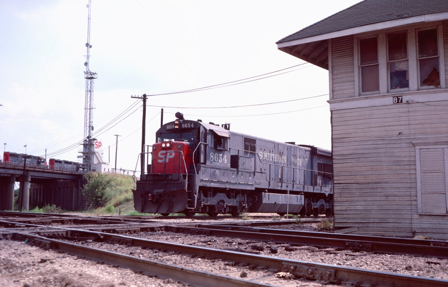
Tower 87 was taken by Gary Morris in 1977. It looks east, opposite from
Barriger's view, with the Interstate 610 overpass visible in the
distance. The Houston, Belt & Terminal (HB&T) tracks are behind the
tower from this angle. When the HB&T tracks were laid c.1907, the
crossing was at the east edge of Englewood Yard. But as the photo shows,
by 1977, additional sidings and yard tracks had been built east of the
tower, south of the main track beneath the freeway. |
 |
By the mid 1880s, Southern Pacific (SP) had
established a major presence in Texas as part of its efforts to complete a
southern transcontinental line from Los Angeles to New Orleans. To cross Texas
from El Paso, SP had proposed to Thomas Peirce that
he extend his Galveston,
Harrisburg & San Antonio (GH&SA) Railway from
San Antonio west to El Paso, with SP providing all
construction financing. Peirce agreed, and around the time construction was beginning in 1881,
SP acquired the Texas & New Orleans (T&NO) Railroad which was already
operating scheduled service between Houston and New Orleans. SP wanted to
control its route through Houston to reach the
T&NO, but the GH&SA did not serve the city on its own tracks. Its main line to
San Antonio began at the Buffalo Bayou riverport of Harrisburg
and passed well south of downtown Houston. SP funded the
GH&SA to build a branch line through town to the north side of Buffalo
Bayou where the T&NO's tracks were located. When the El Paso - San Antonio
construction was finished in early 1883, SP leased and then acquired the GH&SA,
thereby completing its southern transcontinental line via the GH&SA connection
to the T&NO and the T&NO's existing service to New Orleans.
In the early
1880s, SP acquired another major Texas railroad, the Houston & Texas
Central (H&TC) Railway. It had built a main line
from
Houston north to Denison
near the Red River. The river had been bridged by the Missouri, Kansas &
Texas ("Katy") Railway, and the Katy provided a route across Oklahoma and Missouri to Kansas
City and St. Louis. At Houston, the H&TC's tracks were also north of Buffalo
Bayou, and it had built a passenger depot there. Soon, all three SP railroads
were operating out of the H&TC station which was eventually rebuilt as SP's
Grand Central Station. SP's first major yard in the Houston area was at Hardy
Street, north of the bayou near downtown. Early on, Hardy Street Yard was the
effective terminus for freight operations for the H&TC (from the west) and the
T&NO (from the east.) In 1888, SP moved the GH&SA maintenance operations to
Hardy Street from Harrisburg, retaining the facilities at Harrisburg for
industry operations at the rapidly developing riverport along Buffalo Bayou.
The T&NO main line to New Orleans via
Beaumont and Orange passed through open land
northeast of downtown Houston. In 1895, SP built a new yard there, Englewood
Yard, approximately three miles east of Hardy Street Yard. Over time, operations
were sorted out between the yards; Englewood took on greater switching duties
while Hardy Street took on more maintenance work. South of Englewood, SP owned tracks along the north bank of Buffalo Bayou that had been built in 1876
by the Texas Transportation Co. (TTC.) SP laid tracks between
the west end of Englewood Yard and the TTC line, establishing a
connection that became known as Baer Junction.
Baer Jct. gave SP quick access
between Englewood Yard and industries on the north bank of Buffalo
Bayou. It was also near a bridge the Galveston, La Porte and
Houston (GL&H) Railway was building over the bayou leading
south to its new bridge under construction onto Galveston Island.
Seeking SP investment, the GL&H's two new bridges offered an Englewood -
Galveston route much faster than SP's
current route to Galveston over tracks and bridges SP did not control.
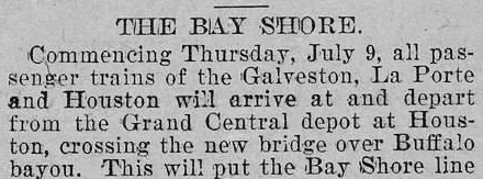
Right: With its
new bridge over Buffalo Bayou completed in late June, 1896, the GL&H
began using SP's passenger station. The GL&H "Bay Shore Line"
was named for its proximity to the shores of Galveston Bay. (Galveston Tribune,
July 7, 1896) |
 |
Before it could attract investment from SP, the GL&H went into
receivership in early 1896. The bankruptcy judge authorized the sale of Receiver
Certificates to finance the remaining work on the GL&H's two new bridges. SP
offered to buy the GL&H in 1897, but the Receiver rejected the $1,000,000 offer.
This was a big mistake given that the GL&H was ultimately sold
at auction in 1898 to its primary construction contractor, L. J. Smith, for
$425,000. In early 1899, Smith sold the GL&H to the newly chartered Galveston, Houston & Northern (GH&N) Railway
of which he was a Director. In January, 1900, SP bought the GH&N, finally
acquiring its own bridge onto Galveston Island (but only for eight
months; the bridge was wiped out by the massive hurricane of September 8, 1900.)
SP planned to merge the GH&N into the GH&SA, but the merger was delayed until 1905 because it required a
charter modification bill to be passed by the Texas Legislature. In the interim,
SP assigned GH&SA managers to the GH&N to oversee operations.
On
March 3, 1907, an interlocking plant nomenclatured Tower 68 was
authorized for operation where the line from Baer
Junction reached the T&NO main line on the west side of Englewood Yard.
There was no main line crossing per se, but the tower undoubtedly had
traditional interlocking responsibilities. There would have been crossing
diamonds for yard tracks and / or parallel main tracks at the junction, plus
main track and siding switches, and numerous signals and derails. It was enough
for the mechanical plant to have 27 functions, more than double the size of a
simple interlocking. Although it supervised a junction, this
was arguably the first "yard tower" in Texas to be commissioned by the Railroad Commission of Texas (RCT.)
RCT's table of active interlockings issued at the end of 1907 identified the
railroads responsible for Tower 68 as "GH&SA Yards". Englewood was shared among multiple SP railroads, but it was built
along the T&NO main line and should presumably have been recorded by RCT as a T&NO tower.
In later reports, RCT listed the railroads at Tower 68 as "GH&SA
Yards, T&NO".
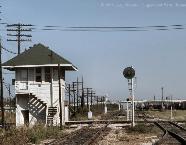
At the east end of Englewood Yard, Tower 87
opened on April 19, 1911. It controlled a crossing that had existed since 1907 when the
Houston,
Belt & Terminal (HB&T) Railway completed eight miles of new track between
Tower 86 and Tower 80,
part of a new line around northeast Houston. HB&T had been founded in 1905 as a
switching and terminal railroad by four companies: the Gulf, Colorado &
Santa Fe (GC&SF) Railway and three railroads controlled by native Texan B.
F. Yoakum, specifically the St. Louis, Brownsville & Mexico (SLB&M), the
Beaumont, Sour Lake & Western (BSL&W), and the Trinity & Brazos Valley
(T&BV.) In 1903, Yoakum had become the Chairman of the Board of the St.
Louis & San Francisco Railway, a major Midwest railroad, and he founded the
HB&T as part of his plan to compete with SP along the Gulf Coast.
In
addition to building Union Station to support passenger services for
several
railroads, HB&T's charter included establishing a belt line around the city to
facilitate freight interchange. Track-laying reports submitted
annually to RCT by HB&T indicate 1907 and 1912 were the primary years of belt
line construction, and there was undoubtedly track work performed during other
calendar years. The end result was a semi-circular belt line around the east
side of Houston along with new tracks north and south out of downtown. The track
segments in east Houston became known as the East Belt. The southern
endpoint of the East Belt was on Santa Fe's branch line into Houston,
just north of a new freight yard, New South Yard,
built by HB&T. Santa Fe's branch line was also used by the SLB&M to reach
Houston from Algoa via
Tower 81 at the south end of New South Yard. It appears that construction of
Tower 87 was part of a major effort by HB&T to interlock multiple crossings it
had created when it built the East Belt. Towers 85, 86 and 87 were all
commissioned in the spring of 1911. HB&T continues to exist, albeit as a paper
railroad owned jointly by UP and
Burlington Northern Santa Fe (BNSF.)
 |
 |
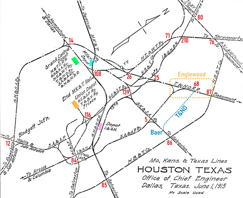
Above Left: This 1915
track chart from the Katy Railroad's Office of Chief Engineer
conveys the complexity of the Houston rail network in the early 20th century.
The map has
been annotated with numbered interlocking towers that controlled various
junctions. [Not all towers are shown, and some that are did not exist when the
map was drawn; the position of the numerals relative to nearby tracks is not
indicative of precise tower locations.] The map is rotated 45 degrees so that
Northwest is "up". It has colored rectangles for the four major passenger
stations that were in use at the time: orange, Union Station; green, SP's Grand
Central Station; purple, International & Great Northern (I&GN) depot; and blue,
the Katy's passenger station. Hardy Street Yard was located where the turntable
("T.T.") is depicted west of Tower 26. Englewood Yard is the orange
dashed rectangle, and the T&NO track (blue dashed line) from the
yard to Baer Junction has been added. It was omitted by mistake, probably due to confusion with the
San Antonio & Aransas Pass (SA&AP) line that paralleled it a mile to the west.
Both lines went north to the T&NO main line; the line from Baer Junction
connected at the west end of Englewood Yard. The tracks south and west of
Tower 5 no longer exist, but the track north of Tower 5 still exists as does the
line from Baer to Englewood.
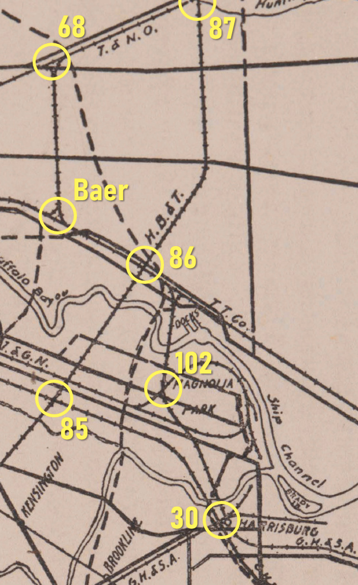
Above
Right: This snippet from a larger 1913 map of Houston includes
the detailed path of Buffalo Bayou and shows the area southeast of
Tower 86 (Magers.)
The aforementioned GL&H bridge over Buffalo Bayou
is just north of Tower 102. By 1913, it belonged to SP, assigned to the GH&SA.
South of the bridge, the GH&SA route to Galveston inherited from the GH&N passed
through Tower 102 and Tower 30 (Harrisburg) before curving east to a routing near the shore
of Galveston Bay all the way to Virginia Point.
There, it accessed the Galveston Island Causeway
built in the aftermath of the Great Hurricane of 1900.
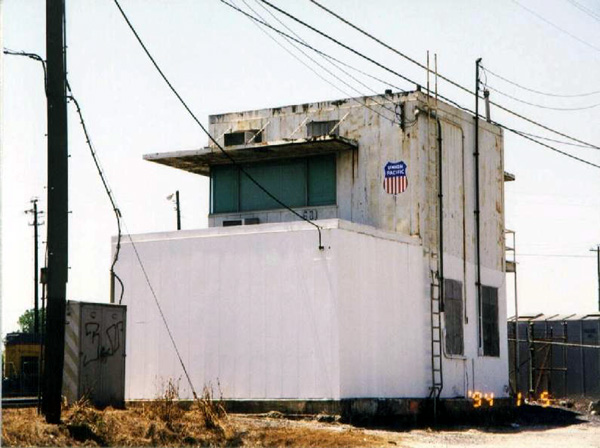 |
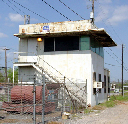
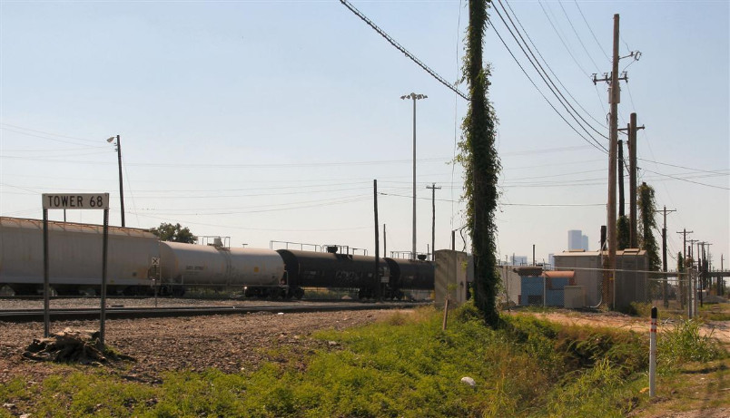
Left: Tower 68,
sometime after the UP / SP merger
(photo by Bill Hale, courtesy of Art Fisher)
Tower 68 was undoubtedly a wooden building when
it opened in 1907. It very likely resembled many other SP towers
in the Houston area
that came before it (Tower 17,
Tower 26, Tower 30)
and after it (Tower 81,
Tower 139.) At some point in the 1948 -
1955 timeframe, Tower 68 was relocated about 800 ft. to the northeast
and rebuilt as the concrete
structure (left) that survived into the summer of 2010. Tom Kline
provided this communication on August 10, 2010:
"Just a short
note to let you know the former SP Tower 68 at
Englewood was removed sometime in the last few weeks.
The relay bungalows are still there but the tower itself is gone. I�ve talked
with a few UP folks to find out what date it was removed and they didn�t even
know about it. I�m still searching for clues. I�m surprised it�s gone with all
the relay and electronic equipment that it housed (so were the UP guys), that
was the reason for its longevity. All reduced to a printed circuit board�." |
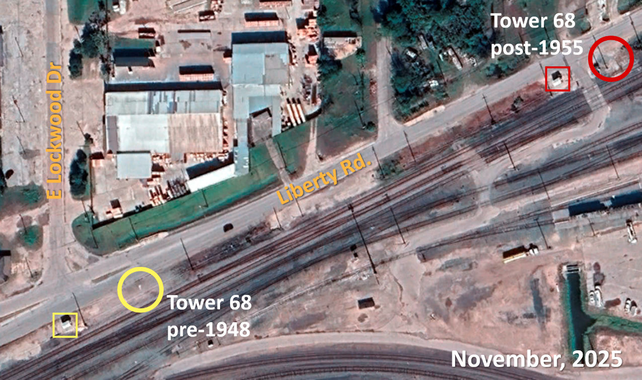
Above: The two known
locations of Tower 68 are plotted on this November, 2025 Google Maps satellite
imagery with yellow and red circles. The yellow circle location is provable on
1930 imagery and remains visible on 1947 imagery. This is presumably Tower 68's original
location; no evidence has been found for a 1907 tower located elsewhere. After 1955, the
red circle location is provable with imagery and first-hand knowledge as the location of the concrete Tower 68. The
only historic aerial imagery between 1948 and 1955 found so far is 1953 imagery
which lacks sufficient clarity to establish indisputably where the tower was
located. The yellow and red rectangles are two nearly identical equipment
cabins installed in 2022, both of which are labeled "CP LF359 Tower 68". It seems odd that they
would have identical labeling 800 ft. apart, but they do.
 |
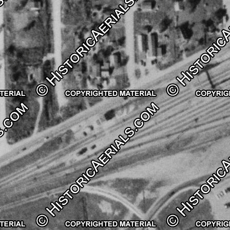
 |
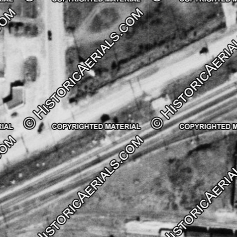
Far Left: The
black spot near the center of this 1947 image is the shadow of Tower 68,
which is
sitting between the main track and Liberty Rd. There appears to be a
white equipment cabin to the right of the tower.
Near Left: The shadow
is gone in this 1956 image, and there's no obvious indication of cabins
or other large structures nearby. It appears that Liberty Rd. has been
paved with asphalt as it is no longer bright white.
both images (c)
historicaerials.com |
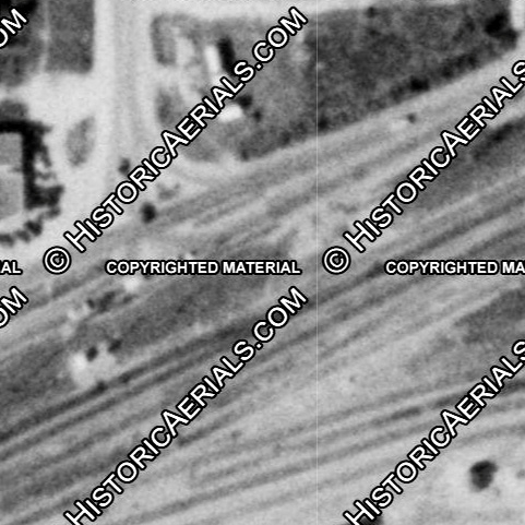
Near
Right: The situation is reversed for the eventual (final) location of Tower 68 eight hundred feet east of the prior
location. This 1947 image does not show any structures between Liberty
Rd. and the main track at what became the site of the concrete Tower 68.
It does show a water tank and its shadow to the right of center, south
of the main tracks. Far Right:
This 1956 image shows the new tower (with visible shadow); the water tank has been
removed. The
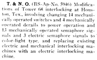
relocation might have been associated with this item (below)
from Railway Signaling in
April, 1944 which described major changes for Tower 68 that might have
taken a few years to execute. (both images (c) historicaerials.com)
 |
  |
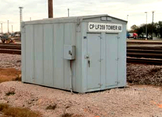
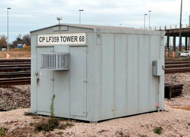
Above Left: Google Street View
shows that this
cabin was being installed in September, 2022 adjacent to the site where the concrete Tower 68 stood,
replacing other equipment cabins that had augmented the electronics for Tower
68. (Google Street View, January, 2026) Above Right:
Also in 2022, a virtually identical cabin was installed at the site where the tower had stood
prior to its relocation c.1948-55. (Google Street View, January, 2026)
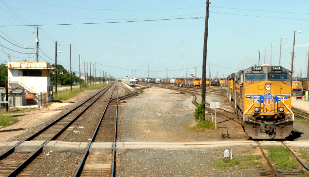
Below Left: Bruce Blalock took
this photo of Tower 68 on May 18, 2008 as he guided his UP locomotive through
Englewood Yard. Bruce comments..."The Englewood Mudge is on the right, where
locomotives go to get their oil and filters changed and the toilet cleaned. I
worked as a hostler / herder there and it was interesting to weave through the
yard to take power to trains and take power off trains."
Below Right: The Tower 68 sign
is still standing, but the building is gone in this photo taken by
Mark St. Aubin in the summer of 2010. The sandy dirt at lower right marks the
site where the tower stood, and beyond that are the equipment cabins that were
replaced by the new cabin in 2022.
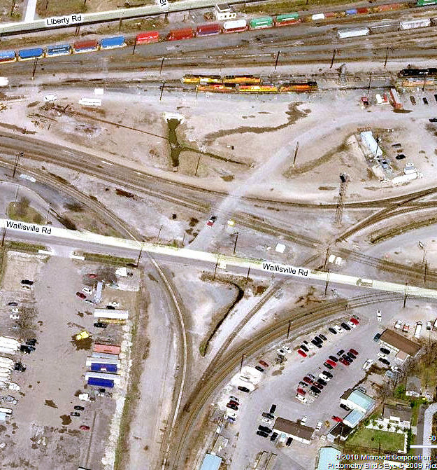
Above: This 2008
Bird's Eye View ((c) Microsoft Corp.) of the west end of Englewood Yard
shows Tower 68 in the center of the top edge of the image, between the
main tracks and Liberty Rd. The line from Baer Junction enters the yard
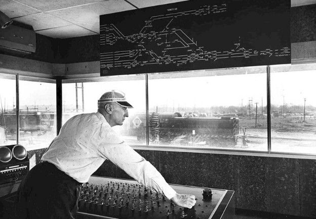
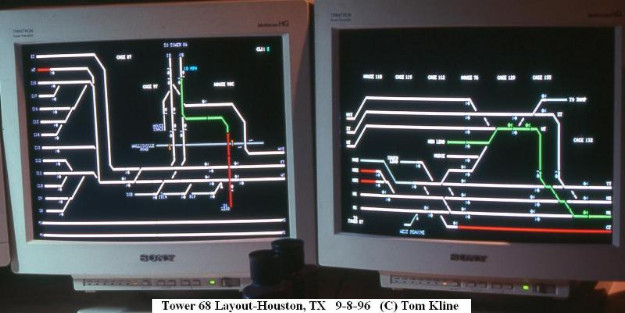
at the bottom of the image. Right:
On this 1996 photo taken inside Tower 68 by Tom Kline, computer screens
display the Englewood track network as part of the operations control system. |
Above: interior of
Tower 68, undated photo courtesy Greg Johnson
 |
Above Left: A southbound HB&T train passes Tower 87 in 1955. (Dean Hale photo,
courtesy Temple Railroad & Heritage Museum)
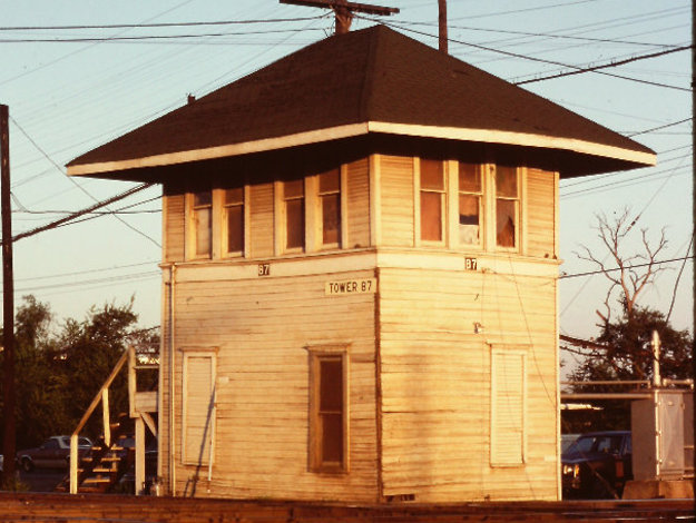
Above Right: Badly in need of a paint job, this photo of Tower 87 (Greg Johnson collection)
shows the staircase on the west face of the tower. Although Tower 87 was operated by SP personnel
-- unsurprising given its location at the east end of Englewood yard -- the
tower was probably designed and built by HB&T. It does
not resemble other SP towers in the Houston area (e.g.
Tower 13, Tower 26) nor elsewhere in Texas
(e.g. Tower 36, Tower 95)
because it lacks the distinctive "fish scale" decoration between the floors that
was common to SP towers in Texas. Good photos of other HB&T towers are
lacking, but to the extent they exist, Tower 87's architecture is not dissimilar
to Tower 84 and Tower 116.
RCT's rule for towers at crossings created after 1901 required the second railroad to
fund the entire capital expense. Here, that would be the HB&T, so it would be typical
practice for the HB&T to have taken the design and construction lead.
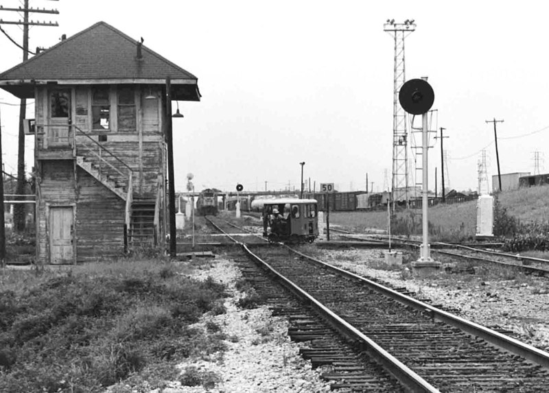
Below Left: Stuart Schroeder supplies this photo and adds..."I
worked at Tower 87 at Englewood late 1981 and early 1982 until the tower was
demolished when the second main track was constructed between Englewood and
Dawes on the Lafayette Sub. My photo is from early 1982 just prior to the
demolition of the tower. As best I recall Tower 87 was razed by mid-82. We moved
into a nearby GELCO trailer with the temporary controls in early 1982 and then
the control center was transferred to HB&T Union Station to be with the HB&T RTC
operator. This was the very first attempt at a joint rail traffic control center
for the Houston area. The second main track was laid where the tower once stood.
... The second main track was already in service by April / May, 1982 when I was
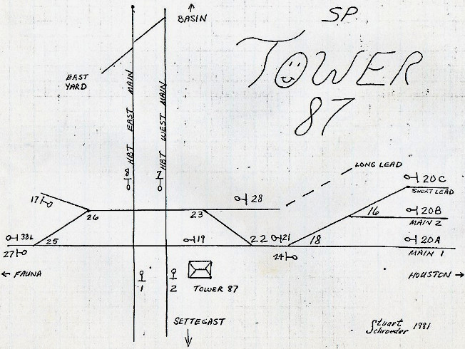
working the SP RTC job at Union Station." Below Right:
This is Stuart's track chart from his notebook in mid-1981 when he was training
at Tower 87; south is "up".
 |
Left and Above: Gary
Perazzo comments on his Tower 87 photos from August, 1980. "I was
working evening shifts on a TOPS project at the Englewood Yard Office
just on the other side of the hump tower. I'd spend my day off time in
and around the tower. Trains on the Sunset Route picked up eastward
orders here..." |
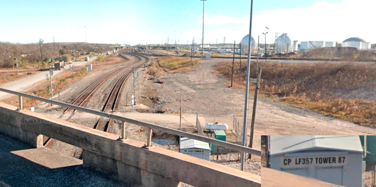
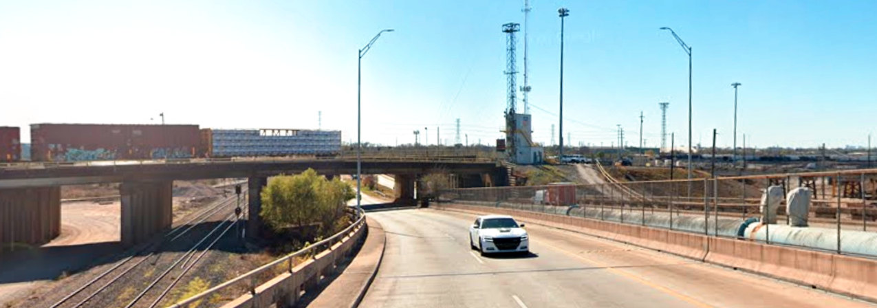
Above: Tower 87 officially
resides in this equipment cabin in the southeast quadrant of the UP / HB&T
crossing, diagonally opposite from the tower's original site. The view is from
the Wayside Drive overpass looking east down UP's former SP main line to
Beaumont. The track at far right crosses over Wayside Drive as it elevates to
reach the top of the hump in Englewood Yard. (Google Street View, January, 2020)
Below: Railcars
are being pushed to the top of the Englewood hump where they will roll past the
yard tower and descend into the yard with switches aligned to send them to the
correct track. This January, 2026 Google Street View looks due south from near
the Wayside Drive overpass of the Tower 87 crossing.