Texas Railroad History - Tower 44 and Tower 167 - Hillsboro
Two Crossings of the Katy Railway
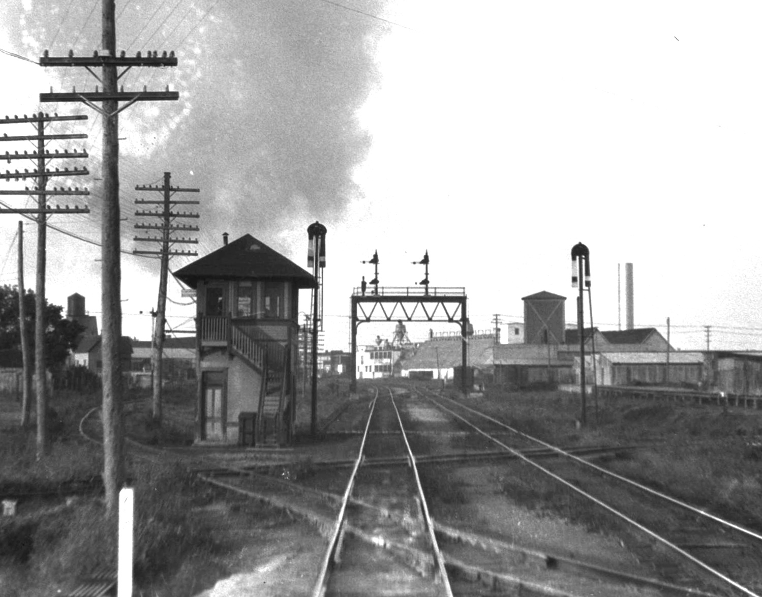 |
Left: Railroad
executive John W
Barriger III took this photo facing south from the rear platform of his
business car as his train passed northbound through Hillsboro on tracks
of the Missouri - Kansas - Texas ("Katy") Railway. Barriger often photographed railroad
structures during his trips, and
here, his shutter finger was triggered by the sight of Tower 44 which hosted an
interlocking plant on the north side of Hillsboro.
Barriger was close enough to the tower that his photo clearly shows the
crossing tracks at this complex junction.
The track passing to the left
of the tower is the Trinity & Brazos Valley (T&BV) line coming from
Mexia
north through Hillsboro continuing to Cleburne. It
crosses the Katy's north / south double track at an acute angle in the
foreground. The other track crossing horizontally is the St. Louis
Southwestern (SSW) from Corsicana entering from the east (left) and
crossing to the west side of the Katy tracks where it turned south and
terminated in Hillsboro. This photo was probably taken in the early
1930s. The T&BV tracks past Tower 44 between Hillsboro and Cleburne were
abandoned in 1932. Salvage operations might not have commenced
immediately, so the tracks could have remained in place for a few years. (photo courtesy John W.
Barriger III National Railroad Library)
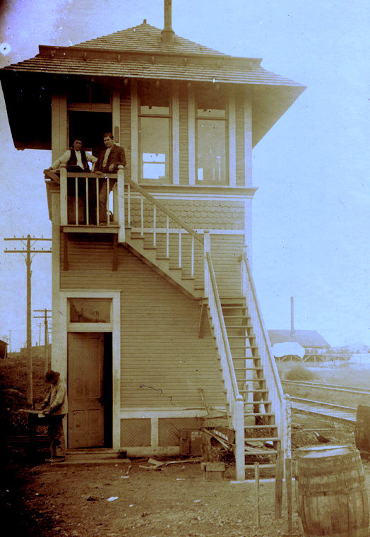
Below Left: Ken Stavinoha provides this image of
Tower 44. Neither the original source of the photo nor its timeframe is known. The reverse side of the photo
has
"Hillsboro" written in pencil.
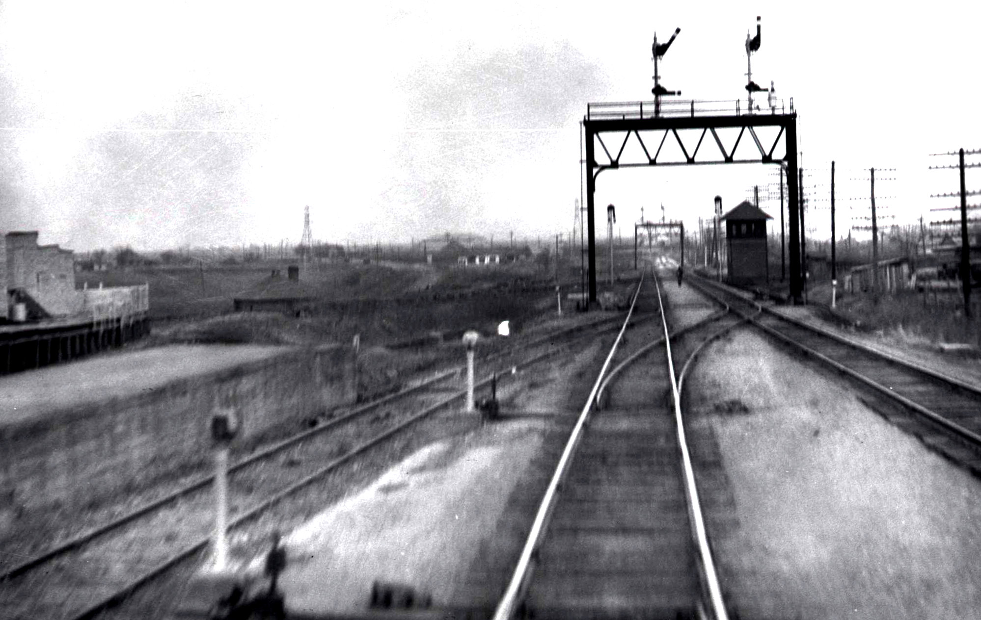
Below Right: This view
of Tower 44 looks north, taken by Barriger some years after the photo at left. A small
hut (purpose unknown) is barely visible in the shadows beside the tower
where the T&BV tracks had been located. The SSW tracks cross the Katy at an angle and pass behind the house and the light colored
building on the left side of the image. (photo courtesy John W.
Barriger III National Railroad Library) |
Hillsboro (spelled Hillsborough until it was changed by
the Post Office) was established as the county seat of Hill County in 1853. The
first railroad into Hillsboro arrived nearly thirty years later in
1881 with tracks of the Missouri, Kansas & Texas (MK&T, "Katy") Railway.
[The corporate name changed to Missouri - Kansas - Texas Railway, MKT, in 1923;
it was still the Katy.] Although the Katy owned the tracks
through Hillsboro, it was arguably the Missouri Pacific (MP) Railroad
that built them, an arrangement attributable to railroad magnate Jay Gould. Gould needed an outlet to Mexico and
ports on the Gulf to maximize profitability of his Midwest railroads, so he decided to
focus on Texas,
eyeing the Katy as a potential component of his long term plan. The Katy had bridged the Red River
into Denison in 1872, exchanging freight
and passengers with the Houston & Texas Central (H&TC) Railway which had
a route between Denison and Houston.
Normally, Gould would simply buy controlling interest in a railroad and name himself
President, but the dilution of Katy stock and the lack of large private blocks
for sale prevented this approach. Instead, over several years he was able to infiltrate Katy
management with his loyalists who paved the way for him
to be named President in December, 1879.
With little personal ownership
of Katy stock, Gould could best reap the benefits of its profitability by
leasing the Katy (in December, 1880) to MP which he
controlled through a
large ownership position acquired in 1879. MP was based in St. Louis and did not have a presence
in Texas. With accounting and operating policies tilted heavily
toward MP, its stockholders would enjoy the profits of the
combined enterprise while Katy stockholders... would not.
Gould directed MP to build from Denison
to Fort Worth, continuing
south to Hillsboro and Waco, eventually to turn
east toward Houston. Except for a large portion of the
Denison - Fort Worth line that was owned by the Texas & Pacific (T&P)
Railway (for which Gould was the effective CEO by the fall of 1880 - he
would become its President in April, 1881),
title to all of the new construction was assigned to the Katy for compliance with Texas railroad ownership laws.
Publicly, particularly in the newspapers, all of the work was presented as an MP operation.
To expedite construction, Gould had MP (Katy) deploy construction forces to Waco
to establish rights-of-way through town and begin building a Brazos River
bridge. There may also have been limited grading north toward Fort Worth to meet the
track gangs building south. Tracks from Fort Worth were a mile south of
Alvarado, 27 miles
north of Hillsboro, by early August. Although a shortage of rails delayed the final push by a few weeks, MP's tracks, owned by the Katy, entered Hillsboro in October, 1881 from the north.
Tracks were complete between Fort Worth and East Waco by mid December, and the
first construction train crossed MP's new Brazos River bridge into downtown
Waco on December 22, 1881.
Above: With
no mention of the Katy, newspapers followed
the progress of MP's construction from Fort Worth to Hillsboro. The Post Office formally dropped the "Hillsborough" spelling in 1888, but as
these items demonstrate, "Hillsboro" had become the preferred spelling years
earlier.
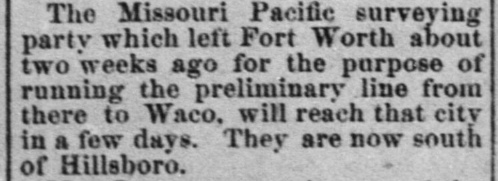
Left: The
Austin Weekly Democratic Statesman of January
13, 1881 discussed the progress of MP's survey party proceeding south from Fort
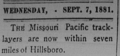
Worth. Center: The
Brenham Daily Banner of September 7, 1881
noted that the tracks were nearing Hillsboro.
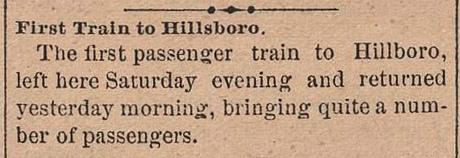
Right: The
Fort Worth Daily Democrat of October 11,
1881 reported on the first passenger train between Fort Worth and Hillsboro.
By the spring of 1881, Gould had begun negotiations to
buy the International & Great
Northern (I&GN) Railroad, Texas' largest at the time. I&GN
profitability was largely dependent on Midwest traffic through St. Louis, but
Gould had gained the potential to interfere with the service by acquiring control of the two railroads that provided the
I&GN's connection to St. Louis. In particular, the I&GN was dependent on the T&P
for service between Longview and Texarkana, and
Gould became T&P President in April, 1881. On June 1,
1881, it was announced that Gould had acquired all of the I&GN common stock in a
two-for-one swap for Katy stock. Gould became President of the I&GN and leased
it to the Katy for 99 years.
Why would Gould lease the I&GN to the Katy? Didn't the Katy own
the I&GN? Although Gould had used Katy stock to acquire the I&GN, he had
obscured the actual ownership by secretly placing the I&GN stock certificates
for safekeeping with his friend in Fort Worth, General Grenville M. Dodge (Chief
Engineer of the T&P, known
most famously as the Chief Engineer for the eastern part of the Transcontinental
Railroad.) Gould was concerned that because the parent Katy corporation was
based in Kansas, its direct ownership of the I&GN might violate Texas law.
If challenged, Gould could claim the I&GN was based in Fort Worth, owned by Gen.
Dodge! The
I&GN continued operating under its own name -- it was well known by the
public but this also helped to present the facade that the I&GN
was not owned by another railroad. For Gould, the less said about this topic, the
better.
MP's problem in Texas was that it could not comply with two elements of state law: it did not have
its
headquarters in Texas and it did not have a Texas railroad charter from the
Legislature. Ironically, the Katy also lacked
both of those requirements!
An 1870 Texas law had authorized the Katy to rely on its Kansas charter for
permission to build into Texas over its planned Red River bridge for the purpose
of connecting to the H&TC. The law also allowed the Katy to build "...in the
general direction of Waco and Austin, to the Rio Grande...". As
indicated by his I&GN stock finesse, Gould was aware of a key legal shortcoming
for the Katy, specifically that it lacked a Texas headquarters, a requirement
added to the Texas Constitution in 1876. Gould's argument for building south from Denison (not that he needed one) would be that he was merely following the
Kansas charter as interpreted by the 1870 Texas law. Gould could have had the
Katy establish a Texas subsidiary corporation and a local headquarters, but that
would take time and might require stockholder approval. Gould wasn't fazed; he knew that politicians always wanted more railroads. It was
hard for legislators to question the legality of MP's southward march with the
Katy while also
making speeches to their constituents at each town's celebration of new MP
service.
MP continued building south from Hillsboro to Waco,
Temple and Taylor,
where construction paused in 1882. Taylor was also served by the I&GN, and
Gould built a Division Headquarters facility there serving both railroads. In
1886, Gould resumed MP's construction toward Houston.
 |
In late 1886, Gould directed MP to build branch lines between
Greenville and Dallas,
and between Dallas and Hillsboro. Gould already had a Katy line from Denison
through Greenville to Mineola that connected there
with the T&P and the I&GN. The new
branches
provided a connection between Denison and Dallas via Greenville, continuing to
the MP main line at Hillsboro. [MP also had a (Katy) Denison - Dallas route via
Denton on the Joint Track.] Typical for new
branch lines, MP chartered new railroads (as subsidiaries of the Katy) to accomplish the
work. For the Dallas - Hillsboro branch, the Dallas & Waco Railroad was
established in late 1886. Financial and legal issues
delayed construction but the line was finally
completed in 1890.
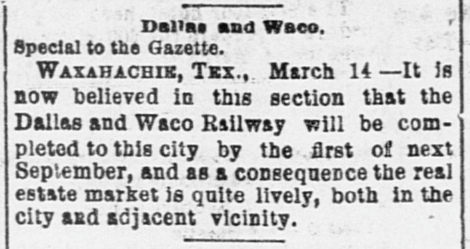
Left:
The Fort Worth Daily Gazette of March 15, 1888 carried this story from
Waxahachie discussing the local real estate
market being stimulated by the approaching rails of the Dallas & Waco.
It would be the town's second railroad in two years, the other being the
H&TC's Ft. Worth & New Orleans Railroad between Ft. Worth and the H&TC main line
at Garrett. By this time, the H&TC was owned by the vast Southern
Pacific (SP) system. |
At the end of 1887,
construction stopped as Gould's rail empire entered a period of financial
turmoil. The issues were mostly with Gould railroads located elsewhere, but in Texas, Gould's problem was the election of James S. "Jim" Hogg as
Texas Attorney General in November, 1886. The focus of Hogg's campaign had been his claim that
Texas railroads were guilty of poor service, poor facilities, price-fixing and
other violations of their charters and other state laws. Hogg
began filing lawsuits against various railroads including the I&GN and the Katy.
Deferred maintenance had caused the I&GN infrastructure to deteriorate leading to poor service and routine
accidents. Gould was unconcerned; travelers were thankful for any
railroad service, particularly in rural towns.
But Texas railroad charters required companies to maintain good facilities and good
service, so Hogg wasted no time going after Gould.
Katy stockholders were
also going after Gould. They had long recognized that he was draining Katy profits into
MP under the lease, but they had also discovered that it was very difficult to summon a quorum for a
special stockholders meeting due in part to the stock dilution. As they began to
get closer to holding such a meeting, Gould undertook diligent efforts to prevent
it and he ultimately resorted to judicial intervention. The stockholders eventually
prevailed in court and were allowed to hold a meeting in May, 1888. They fired Gould for
malfeasance associated with the terms of MP's lease and then promptly sought
bankruptcy protection, asking the court to declare that MP's lease
was unlawful because it resulted in violations of Texas law, an argument that
Gen. Hogg had made in his lawsuit against the Katy. In 1890, the Texas Supreme Court confirmed the termination of MP's
lease while also confirmig that the Katy was a "foreign" railroad
because it lacked both a Texas charter and a Texas headquarters. While this
ejected MP from any presence in Texas, it also created an
enormous mess pertaining to Katy assets and its operations in Texas. The
bankruptcy court
retained supervision of the Katy while the
Legislature sorted it all out.
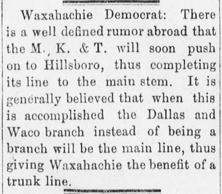
Above: With Gould dismissed
and the MP lease voided, the Katy was under the protection of a Kansas bankruptcy
court which had permitted it to continue its operations and branch line
construction while waiting for the Texas Legislature to act. The Dallas & Waco
had stopped at Waxahachie in early
1888, but it had built as far as Milford by the end of 1889. This prompted the Waxahachie Democrat
(quoted left by the
Hillsboro Mirror of January 29, 1890) to
speculate on the branch line from Dallas becoming the main line to Denison via
Denton or Greenville (i.e. instead of
the Katy's Hillsboro - Denison route via Fort Worth.)
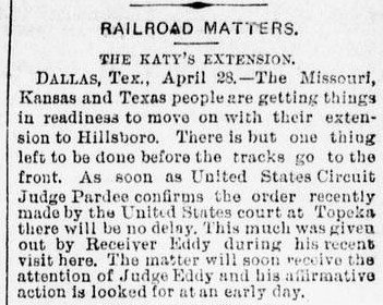
By April (center,
Galveston Daily News, April 29, 1890) it
was becoming clear that the Federal courts would not present any impediments to finishing the Dallas & Waco
branch to Hillsboro.
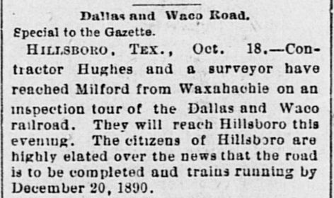
Right: The Fort Worth Daily
Gazette of October 19, 1890 predicted two additional months to
complete the track-laying into Hillsboro. Later newspaper reports indicate that
delays pushed the commencement of Dallas - Hillsboro service into
February, 1891.
The Katy would continue
to operate in Texas under its Receiver, Kansas businessman George A. "Judge" Eddy, until it could be
reorganized pursuant to a new Texas charter to be enacted by the Legislature.
The Katy asserted its rightful ownership of the I&GN, intending to fire Gould from his
position as I&GN President. Exceedingly clever legal shenanigans by Gould
prevented that from happening. First, Gould made a very short term personl loan
to the I&GN and then, as IG&N President, refused to pay it back. With the debt
unpaid, Gould
then forced the I&GN into bankruptcy for failure to repay. This gave
the I&GN (and thus, himself) the protection of the bankruptcy court, preventing
the Katy from removing him as I&GN President. As the Katy sought to intervene in
the I&GN bankruptcy litigation (so it could repay the debt and fire Gould), Gould approached
Gen. Hogg privately to admit that the I&GN
really was owned by the Katy
(which Hogg had speculated but couldn't prove.) Gould reminded Hogg that the
Katy was a "foreign" railroad that might soon own the I&GN. Hogg was vigorously opposed to the idea of a "foreign"
company owning Texas' largest railroad, so he filed an injunction to
prevent the Katy from taking any action to oust Gould. Keeping the I&GN out of
the Katy's hands long term would ultimately deliver it to Gould.
The Legislature finally passed a
Katy charter law on October 28, 1891 granting rights to a newly created
Texas subsidiary of the parent Katy corporation. The Texas-based Katy subsidiary
would be headquartered at
Denison and it would own most of the Katy's current Texas rail lines, but
not the I&GN. Gould's delaying tactics had
provided time for Hogg to lobby the
Legislature into souring on the idea of allowing the Katy to own the I&GN, leaving the
Katy with little choice but to sell it back to Gould for the paltry sum of
$350,000. Why so little? Gould still controlled the T&P and MP, the two
railroads that comprised the I&GN's best route between Longview and St. Louis
via Texarkana. No railroad was willing to risk the wrath
of Gould to outbid him.
The new Katy charter bill
was signed into law by Texas Governor ... Jim Hogg! His lawsuits against the railroads had boosted his political standing, enabling him
to win the Governor's race of 1890. During the campaign, Hogg proposed the
creation of the Railroad Commission of Texas (RCT), and a law was promptly enacted in 1891
creating the agency. Ten years later, a new state law would grant RCT the power
to manage rail junction safety for both at-grade and grade-separated crossings,
leading to the
introduction of interlocking plant technology in Texas.
After being freed from the MP lease by the Texas
Supreme Court, the Katy remained an independent railroad for nearly a hundred
years. It was acquired by Union Pacific (UP) in 1988 and merged back into MP which UP had acquired in 1982.
MP continued operating under its own name until 1997 when UP consolidated all of
its railroads under the UP name (by this time, including SP.) Thus, the tracks through Hillsboro originally
built by MP but owned by the Katy now serve as a major north
/ south line for UP.
 |
The next railroad into Hillsboro was the Cotton
Belt in February, 1888. It had originally been chartered as the Tyler Tap Railroad in 1871 to bring rail service to
Tyler by "tapping" the T&P at
Big Sandy, which
occurred in 1877. Two
years later, the name was changed to the Texas & St. Louis (T&SL) Railway when a 107-mile segment was built from
Big Sandy to Texarkana extending into Arkansas.
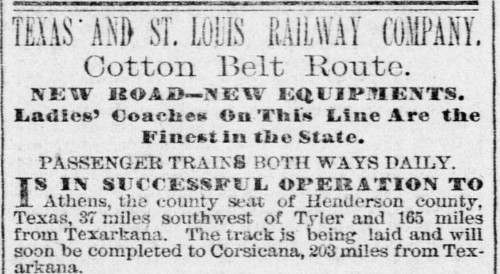
Right: The T&SL's
first ad in the Galveston Daily News
ran in the issue of January 21, 1881. It is historically significant
because it shows the T&SL claiming the moniker "Cotton Belt Route".
While "cotton belt" was a common geographic and geopolitical term for
various cotton-producing areas in the South, this is the first known
instance of the T&SL using "Cotton Belt Route" as a marketing
nickname for
the railroad. The public embraced it; the nickname would reference an operational
Texas railroad for the next 110 years.
Gould viewed the T&SL as
a genuine threat to his business, leading to a significant right-of-way
skirmish in Waco. By 1883, the T&SL was operating from Bird's Point, Missouri on
the Mississippi River to Waco and beyond. Overextended, the
T&SL entered receivership in 1884
(which probably kept it from falling into Gould's hands.)
In February, 1886, the
St. Louis, Arkansas & Texas (SLA&T) Railway was created
by the bankruptcy judge to become the new Cotton Belt, going against
the advice of T&SL President Sam Fordyce who believed unsolved
operational issues would doom the enterprise. Despite Fordyce's
concerns, he became President of the SLA&T. Within a year, Fordyce
had decided
to compete with Gould by building new branch lines in north Texas, one
of which would be from Corsicana to
Hillsboro.
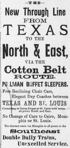
Left: The
Cotton Belt -- identified only by its nickname -- aggressively promoted
its faster route to Memphis and St. Louis with "No Change of Cars..." This ad
appeared in the Hillsboro Mirror
of January 15, 1890, but it was generic; it did not mention any Texas
towns. |
 |
The MP (Katy) line
from Fort Worth had stimulated commerce and population in Hillsboro, but the town
lacked a direct route to the northeast toward St. Louis, Memphis and the
east coast. Fordyce's Corsicana - Hillsboro branch line would create
such a route via Texarkana
that was significantly faster for Hillsboro residents than what Gould could offer. Railroad committees in
both Hillsboro and Corsicana backed Fordyce's plan, and they
agreed that the branch should take a
southern route through the community of Dresden.
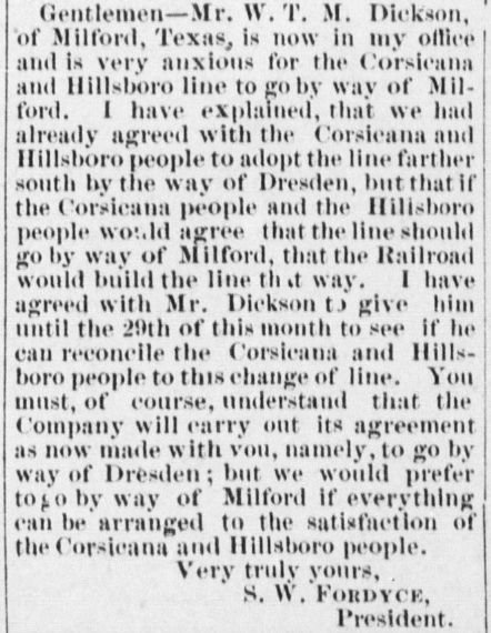
Left, Top: The
Hillsboro Reflector of May 26, 1887
printed this letter sent by Fordyce to the railroad committees to make them aware of strong interest on the
part of the citizens of Milford to be on the proposed SLA&T branch line.
Milford was thirteen miles northeast of Hillsboro, somewhat out of the
way for an optimum route from Corsicana. Yet, Milford's representative had
been able to convince Fordyce of the value of routing through there. When construction actually occurred in 1887-1888, neither Milford
nor Dresden was on the branch line. Instead, the route was a more direct path through Blooming Grove and
Mertens. Milford would gain rail service in
1889 when the Dallas & Waco built through the community. Dresden, thirteen miles southwest of Corsicana, never obtained rail service.
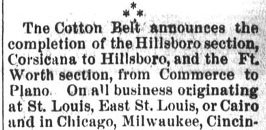
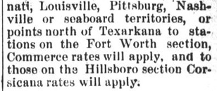
Left, Bottom: The
Temple Daily Times of February
9, 1888 announced inauguration of Cotton Belt service to Hillsboro from
Corsicana.
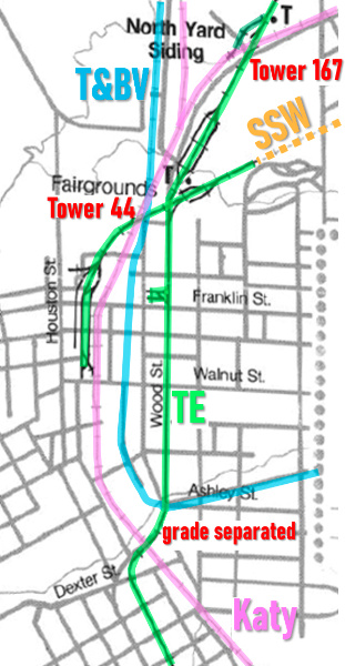
Right:
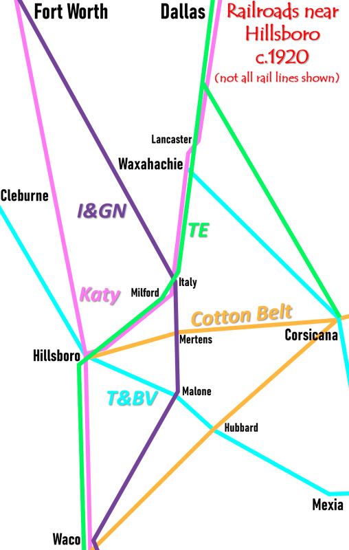
This map highlights railroads through Hillsboro c.1920. In 1913, an
electric interurban subsequently known as the Texas Electric (TE) built
into Hillsboro, crossing the Katy at grade on the north side of town.
That crossing became the location of Tower 167 in 1931. The TE also had
grade-separated crossings of the Katy and the T&BV on the south side of
town. |
 |
Knowing the Cotton Belt was on thin ice financially,
Gould made a secret agreement with Fordyce in 1888 for MP and the Cotton Belt to cooperate on
traffic through Texarkana. This gave Gould the opportunity to assist
Fordyce with loans and by making private SLA&T stock purchases, gaining valuable financial
leverage. Gould was thus positioned to influence the reorganization when the
Cotton Belt became insolvent in 1889 (as Fordyce had
predicted.) The next bankruptcy plan created a new railroad dominated by
Gould known as the St. Louis Southwestern Railway (SLSW or SSW, but
more commonly just Cotton Belt.) Gould installed his younger son
Edwin as President of the Cotton Belt, and Edwin ran a profitable railroad for
more than three decades, retiring in 1925.
Jay Gould died in December,
1892 and was succeeded by his son George as President of MP, the T&P and the
I&GN. By 1917, the Gould family was no longer involved with any of those
railroads.
 |
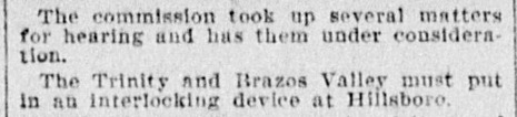
The next railroad into Hillsboro was the
Trinity & Brazos Valley (T&BV) Railway chartered
there in 1902 to build southeast to
Mexia, ostensibly heading for
Beaumont. The Mexia line was completed in 1904
along with a northwest extension from Hillsboro to
Cleburne. The T&BV was acquired
on August 1, 1905 by the Colorado & Southern (C&S) Railway as part of a grand plan by
C&S Board member Benjamin Franklin Yoakum to build a major north / south line
between Fort Worth and
Houston. Yoakum, a
native Texan born near Mexia,
had advanced from a track gang on the I&GN to become
simultaneously the CEO of both the Chicago, Rock Island & Pacific
(CRI&P) Railroad and the St. Louis & San Francisco ("Frisco")
Railway, two major Midwest railroads that were attempting to merge.
Both railroads had built tracks from Missouri and Kansas through
Oklahoma into north Texas. Yoakum had begun assembling a
Houston-based collection of small railroads that would span from New
Orleans to Brownsville and compete with SP along the coast. Known by the marketing name the Gulf Coast
Lines (GCL), Yoakum's lack of a connecting route between Houston and
Dallas / Fort Worth made it particularly galling to be handing freight
over to SP to be carried between the
GCL and his north Texas railroads. Yoakum began his project for a north
/ south line by building Rock Island tracks from
Fort Worth to Dallas in 1903.
To build to Houston, Yoakum needed the T&BV's charter which could be
modified easily. Getting a new charter from the Legislature
would encounter stiff opposition from other railroads. Yoakum had
befriended Edwin Hawley, a well known railroad investor and the
principal owner / financier of the C&S. Teaming with Hawley added
financial heft to Yoakum's railroad play in Texas. Hawley was willing to
buy the T&BV because Yoakum's plan would eventually yield a C&S route
from Denver to Houston
and Galveston. The C&S already had Denver - Fort Worth service
operated in Texas by its Fort Worth-based subsidiary, the Fort Worth &
Denver City (FW&DC) Railway. [The 'C' was dropped in 1951, becoming
simply the FW&D.] After Hawley acquired the T&BV, he sold a
half-interest to Rock Island.
To extend the T&BV toward Houston
and Dallas, Yoakum first built across the H&TC tracks at Mexia toward the community of Brewer, eleven miles
distant. Brewer (which Yoakum renamed Teague, his mother's maiden name)
was at the midpoint of a Houston - Dallas route that Rock
Island surveyors had mapped in 1903. It would host a major yard and maintenance shops for
the T&BV. Yoakum's northward construction from Teague stopped at Waxahachie
where he obtained trackage rights on the Katy into Dallas. Southward
into Houston, the T&BV connected with the Houston Belt & Terminal
(HB&T) Railway, a property
Yoakum had founded to build a union depot and to function as a switching railroad
around Houston. The HB&T connected to the two GCL railroads that served
Houston - the St. Louis, Brownsville & Mexico (south) and the
Beaumont, Sour Lake and Western (east.)
 Right:
The Houston Daily Post of
February 21, 1903 reported that RCT had ordered the T&BV to build an
interlocking tower at Hillsboro. By RCT rules, the T&BV had to pay the entire capital
expense because its tracks arrived at the crossing after 1901. Prior to
the T&BV, RCT had not required an interlocker for the Cotton Belt (SSW) / Katy
crossing at Hillsboro. Right:
The Houston Daily Post of
February 21, 1903 reported that RCT had ordered the T&BV to build an
interlocking tower at Hillsboro. By RCT rules, the T&BV had to pay the entire capital
expense because its tracks arrived at the crossing after 1901. Prior to
the T&BV, RCT had not required an interlocker for the Cotton Belt (SSW) / Katy
crossing at Hillsboro.
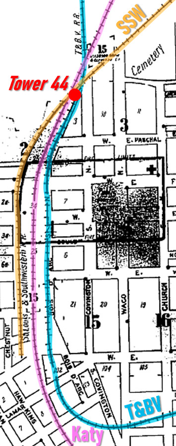
Left:
This index for the 1911 Sanborn Fire Insurance map set of Hillsboro has
been annotated to show the parallel paths of the steam railroads through
Hillsboro and the location of Tower 44 where they crossed on the north
side of town. RCT commissioned Tower 44 on July 7, 1904 as a mechanical
interlocker with 24 functions. All three railroads, the Katy, Cotton
Belt and T&BV, shared the tower's
recurring operations and maintenance (O&M) expenses, but the
specific apportionments are undetermined.
That same day, July 7, 1904, RCT
also commissioned towers at Cleburne, Malone and
Hubbard. Like Hillsboro, all were on the T&BV's Cleburne - Mexia
line. The T&BV likely ran a special passenger train to carry the
inspector and supporting railroad personnel along the route to optimize
the time that would otherwise be required to inspect all four towers.
Their construction had begun more or less simultaneously, and RCT had
numbered them consecutively west to east along the T&BV line -- Towers
43 through 46. All four were erected
and commissioned prior to the C&S acquisition. At Tower 44, the Katy had
the O&M responsibility (per 1916 RCT report) but it seems unlikely
that the Katy had led the design and construction of Tower 44. Other
Katy towers in Texas (e.g. Tower 53,
Tower 64, Tower 93,
Tower 109) were concrete but Tower 44 was
built with wood, most likely by the T&BV which had the capital
expense obligation. The Katy
might have taken over the O&M responsibility when the T&BV entered a
lengthy receivership in 1914. |
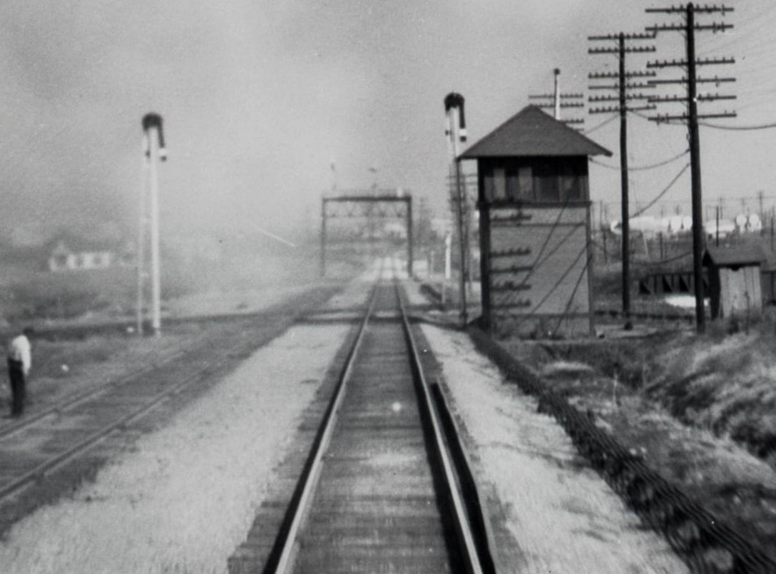
Above: Barriger took
this photo of Tower 44 sometime in the latter 1930s after the T&BV had
been abandoned. The hut at far right sits atop the T&BV right-of-way
beside the tower. Barriger's view is to the north from the rear platform
of his business car on a southbound Katy train. (photo courtesy John W.
Barriger III National Railroad Library)
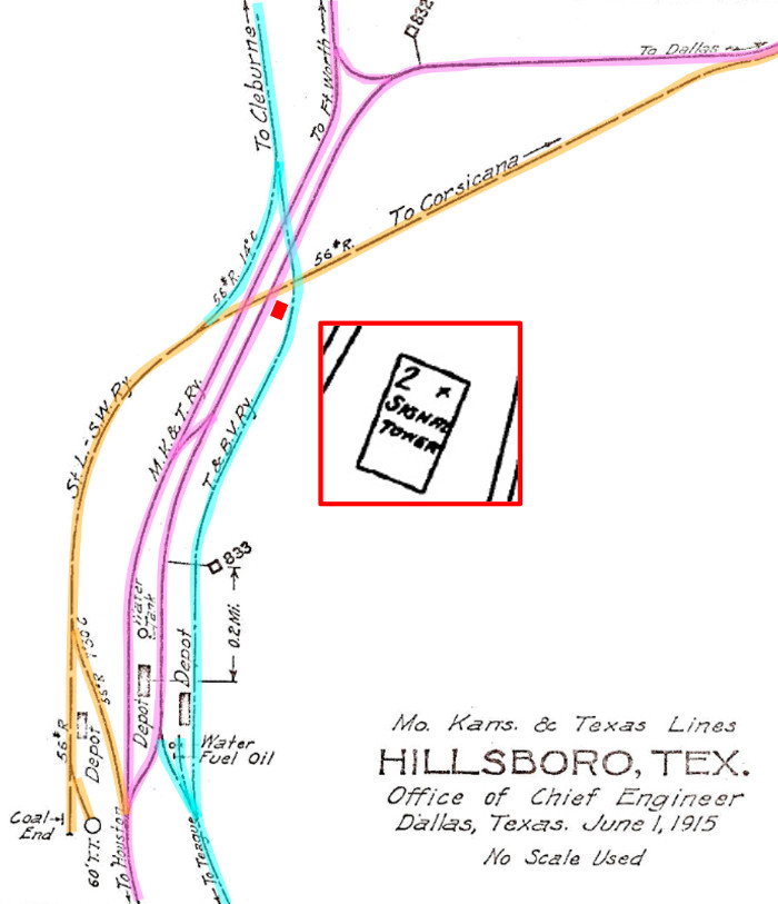
Right: This track chart of Hillsboro (Ed
Chambers collection) was produced in 1915 by the Katy's Office of
Chief Engineer. It shows several connecting tracks among the railroads, and indicates that the two parallel Katy
tracks through town combined to a single track south of the Katy
depot. Although the electric interurban was in operation through
Hillsboro in 1915, its tracks do not appear on this chart. The red
rectangle shows the location of
Tower 44 which is depicted on the 1924 Sanborn Fire Insurance map of
Hillsboro as a 2-story Signal Tower with a door on the north side.
Although external staircases on towers were sometimes illustrated on
Sanborn maps (e.g. Towers 9 and 41 in
Navasota), Sanborn's cartographer did not do so here for the staircase
on the north side of Tower 44 (see photos at top of page.) |
 |
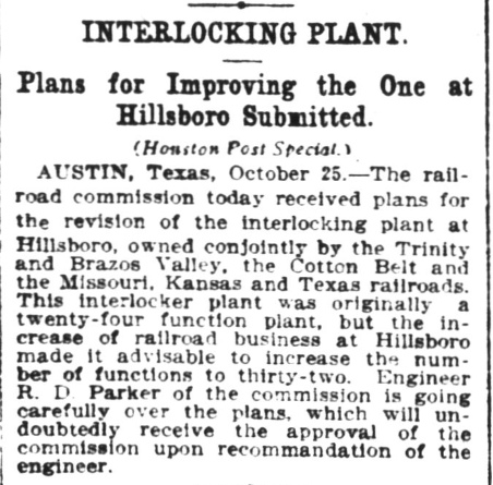 |
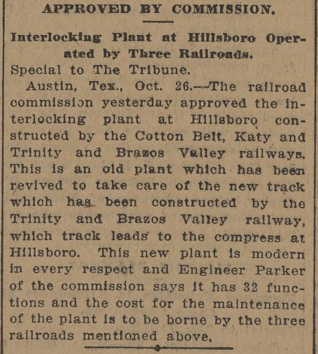
Left: A news report in
the Houston Post of October
26, 1910 discussed plans submitted to RCT a day earlier for expansion of Tower 44's
interlocking plant. The plant's function count would increase from 24 to
32 to account for signals, switches and derails necessitated by a new
T&BV track across the existing rail lines to serve a cotton
compress.
Right: Although the
Post story described the plans
as being "received" on the 25th, the
Galveston Tribune of October
26 reported
that RCT had "approved" the new plans on the 25th. |
 |
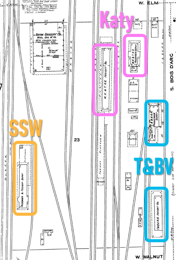 |
Left: This
snippet from the 1911 Sanborn Fire Insurance map of Hillsboro has been
annotated to show that each railroad built its own freight and passenger
depots, except the Cotton Belt, which built a combination depot.
Hillsboro did not have a Union Depot. Since the railroads had
parallel main tracks and sidings through town, walking between passenger
depots was a safety issue. In 1906, RCT reported an average of 53 trains per day past
Tower 44, but the frequency of operations was probably higher during daylight hours near
the depots due to switching movements that did not need to go as far
north as Tower 44. Overall, it was a dangerous place for passengers to
change railroads.
The Texas Legislature
gave RCT the authority to order railroads to collaborate on building
union passenger depots wherever RCT deemed it to be a worthwhile expense
in the interest of the traveling public. Hillsboro was Exhibit A for a
town where construction of a union depot would improve safety and
convenience for a significant number of daily travelers. RCT ordered the
three railroads to build a union depot at Hillsboro, but the order was
met with resistance by the railroads.
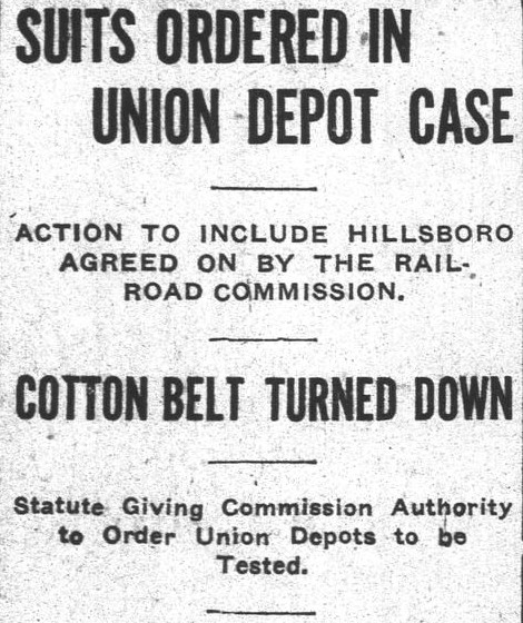
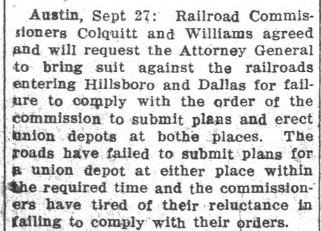
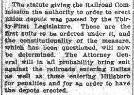
Above: The
Lancaster Herald of September 30,
1910 reported on RCT's decision to file suit against the railroads for
failure to execute orders to build union depots at Hillsboro and Dallas.
The railroads at Dallas soon complied with RCT's order. |
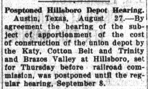
Above Left: Four years later,
the
Brenham Daily Banner of August 27, 1914
reported postponement of a hearing planned by RCT to discuss the apportionment
of costs to the railroads for a union depot at Hillsboro. By this time, the
railroads had generally agreed to build a union depot but were vigorously opposed
to RCT's cost
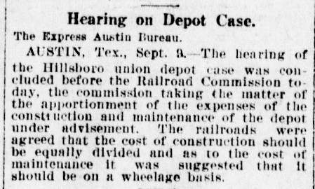
sharing plan. Above Center: The postponed hearing took place on September 9
as reported by the San Antonio Express
of September 10, 1914. While the railroads had agreed to share the capital cost
of the depot, no agreement had been reached for the cost of staffing and
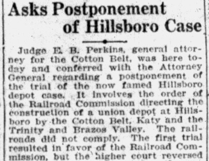
maintaining it. Above Right:
Eighteen months later, the Austin Statesman and
Tribune of April 12, 1916 reported that the Cotton Belt was
conferring with the Attorney General regarding postponement of the upcoming
district court trial in the "famed Hillsboro depot case." The story goes on to
explain that RCT had won the original trial ruling but an appellate court had
reversed the lower court because it deemed the cost sharing formula to
be unfair. A postponement of the trial was inevitable because both the Katy and
the T&BV were now
under the protection of Federal bankruptcy courts and thus could not be forced
to answer a state court summons. The Katy chose (and was eventually allowed) to
participate in the trial.
Below Left:
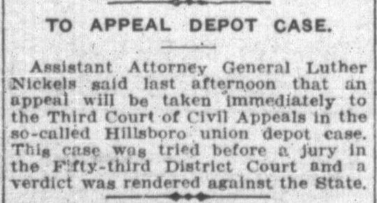
The Austin Statesman of November 24,
1916 reported that the State of Texas would appeal the ruling of the trial court
in the "so-called Hillsboro union depot case." The case had been tried before a jury
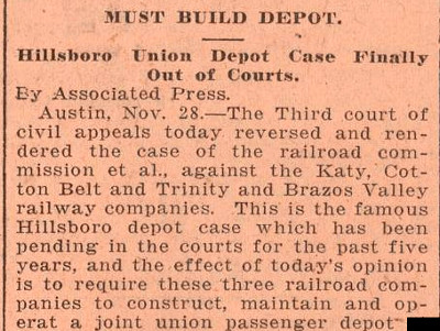
in Austin. Below Center: Proclaiming
a year later that "Hillsboro Union Depot Case Finally Out of Courts"
(a subhead no one believed),
the Galveston Tribune of November 28,
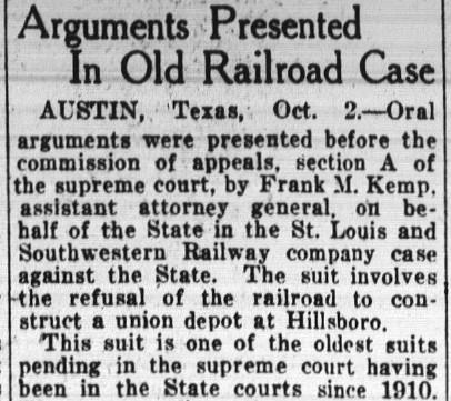
1917 reported the State had won its appeal. Below
Right: The Houston Post
of October 3, 1923 reported on oral arguments presented to an appellate
commission assigned by the Texas Supreme Court to hear the "Old Railroad Case."
Significant delay was attributable to the
nationalization of the railroads during World War I under the U. S. Railroad
Administration (USRA) which had commenced one month after the November, 1917
appellate ruling. The USRA had the power to force railroads to share
depots. Whether this occurred in Hillsboro is undetermined, but it seems likely. The USRA was decommissioned
by the Transportation Act of 1920 which also granted the Interstate Commerce
Commission significant powers over the railroads. The Katy (1915 - 1923) and the
T&BV (1914 - 1930) were both in Federal receivership which could also have
inhibited any attempt by state courts to resolve the case. The Katy emerged from
bankruptcy on April 1, 1923.
So how did it all end?
Under the headline "Hillsboro Depot Case To Be Tried Here; Set For December
8", the Austin Statesman of November 19, 1924 explained that yet another
trial was to be held regarding the apportionment of expenses for building and
maintaining a union depot at Hillsboro. The last line of the story was "Any
way that the case is decided by the trial court, it will again be appealed to
the higher courts." That was undoubtedly true, but no subsequent newspaper
stories about the potential Hillsboro union depot have been found. The case seems to have simply
disappeared. The operations of the T&BV during its lengthy receivership were
probably cut back, so its connecting passenger count at Hillsboro was probably
very small. Cotton Belt service to Hillsboro was on a lightly used branch line that
terminated there, so the number
of inconvenienced passengers might also have been tiny. In the end, only the Katy had significant passenger traffic
through Hillsboro, and its depot was adequate for that purpose. Passengers that
previously had depended on the Katy for travel to Fort Worth and Waco now had an
electric interurban line serving Hillsboro, and its depot was not near the steam railroad tracks. No evidence has been found to indicate that a union depot was
ever built at Hillsboro.
 |
 The
T&BV was in receivership from 1914 until 1930 when the Burlington - Rock
Island (B-RI) Railroad was created as a paper entity to take ownership of the
T&BV's assets. The B-RI was owned in equal shares by the Burlington
system (successor to the C&S) and Rock Island. Burlington assigned its
B-RI ownership to the FW&DC. Rock Island's half interest
was assigned to its Texas subsidiary, the
Chicago, Rock Island &
Gulf. B-RI quickly abandoned unprofitable tracks from Hillsboro to
both
Cleburne (1932) and Hubbard (1935.) The tracks from Hubbard to Mexia
were
abandoned in 1942. The
T&BV was in receivership from 1914 until 1930 when the Burlington - Rock
Island (B-RI) Railroad was created as a paper entity to take ownership of the
T&BV's assets. The B-RI was owned in equal shares by the Burlington
system (successor to the C&S) and Rock Island. Burlington assigned its
B-RI ownership to the FW&DC. Rock Island's half interest
was assigned to its Texas subsidiary, the
Chicago, Rock Island &
Gulf. B-RI quickly abandoned unprofitable tracks from Hillsboro to
both
Cleburne (1932) and Hubbard (1935.) The tracks from Hubbard to Mexia
were
abandoned in 1942.
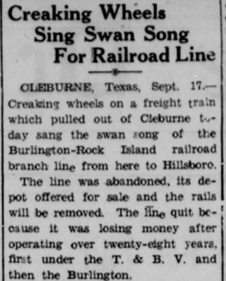
Left: On September 20, 1932, the
Delta Courier of Cooper, Texas
carried this story on B-RI abandoning its Cleburne line.
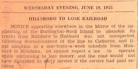
Right: The Ennis Daily News of June
19, 1935 opined on the demise of the B-RI line from Hillsboro to
Hubbard which resulted in Hillsboro no longer having any B-RI service.
Several
sections of Hwy. 171 between Mexia and Cleburne are built on the former
T&BV right-of-way. State Highway 22 occupies the T&BV right-of-way
between Interstate 35 and downtown Hillsboro. The T&BV branch between
Mexia and Teague was abandoned in 1976, but its main line from Teague north to Waxahachie and south to Houston
is now a major line owned by
Burlington Northern Santa Fe (BNSF.) |
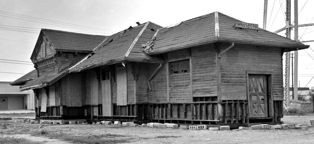 |
Left: In this undated photo,
the Katy depot in Hillsboro had seen its better days and may have been headed
for demolition. (Texas Historical Commission image) |
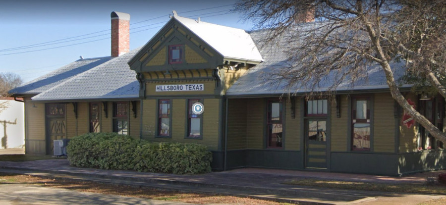 |
Left: Instead, the depot was restored to host the local
Chamber of Commerce and it also serves as the town's Visitor's Center. (Google
Street View, 2019) |
 |
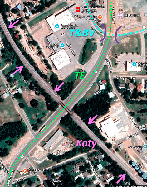
In 1913, the Southern Traction Co. completed an electric
interurban rail line from Dallas to Waco that passed through Hillsboro.
In addition to moving passengers, the interurban also hauled box cars
and package freight. At the north edge of Hillsboro, the interurban
crossed the Katy line to Dallas at grade. A connecting track was added
at the crossing to facilitate freight car exchanges between the Katy and the interurban. In 1917, the Southern Traction Co.
merged with the Texas Traction Co. to form the Texas Electric (TE)
Railway, the largest interurban system in Texas. On February
10, 1931, Tower 167 was commissioned by RCT as a 4-function mechanical
interlocking plant to control the TE / Katy grade crossing.
TE employees were responsible for operating the interlocker, most likely
a member of the TE train crew disembarking from his stopped train to
operate controls mounted trackside near the crossing. The Hillsboro installation appears to have
been part of a larger effort to add interlocking plants to TE crossings of steam railroads, the others being
Tower 165 (Corsicana),
Tower 166 (Plano) and
Tower 174 (Italy.)
Left: This annotated
snippet of a larger map ((c) Johnnie Myers, 1953) shows the TE / Katy
crossing at Tower 167 on the north side of Hillsboro. After the SSW was
abandoned between Hillsboro and Corsicana in 1940, the TE began using
the SSW tracks to reach warehouses and businesses that still wanted
service. The TE also repurposed the abandoned SSW depot. The TE crossed the SSW at
grade near Tower 44 but the crossing was not part of Tower 44's controls
and there's no evidence it was ever interlocked. The short east / west green lines on the
map near Franklin St. mark the location of the TE station at the corner
of Waco St. and Fancher St. (now the home of
R&K Cafe II.) At the south end of Hillsboro, the TE had
grade-separated crossings of both the T&BV and the Katy, passing beneath
both lines. Although the
map shows Wood St. hosting the TE rails, the 1925 Sanborn Fire Insurance
map of Hillsboro identifies it as Waco St., a name still in use today.
The TE ceased operations at the end of 1948.
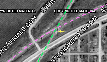 
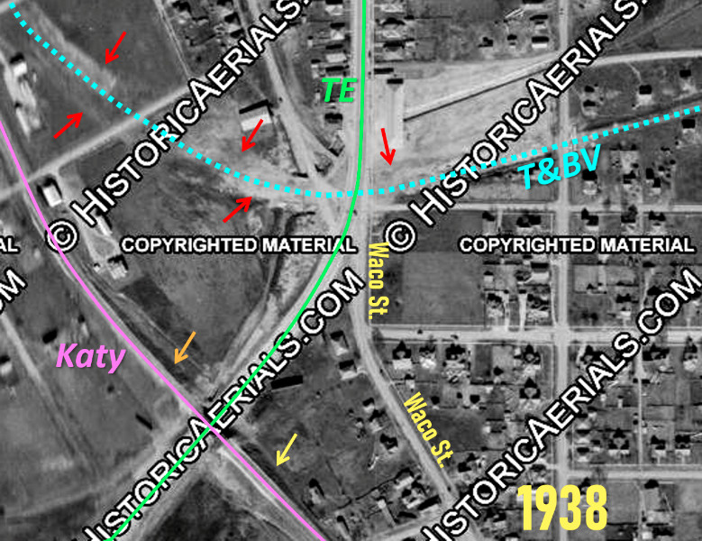
Left:
The TE (green) / Katy (pink) grade crossing is shown in this 1938 aerial
image ((c)historicaerials.com.) The yellow arrow points to the Tower 167
control cabin south of the diamond. Under magnification, the cabin and
its short shadow to the north are more apparent.
|
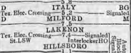
Right:
A Katy Employee Timetable (ETT) dated August 24, 1933 identified the
location of the TE crossing at Hillsboro as "Lakenon" and noted
that it was "Signaled" instead of "Interlocked." True interlocking machines incorporated time
delays to deconflict signal changes in the presence
of approaching trains. The TE interlockers did not. Their operation depended on TE train crew to observe
the track before operating the controls to signal a STOP indication on
the Katy. Below:
The same ETT listed specific freight and passenger train speed limits
when approaching the TE crossing signals at Italy and Hillsboro. This
might have pertained to the fact that the Katy's signals were not truly
interlocked at these crossings.
 |
 |
Above: These two photos (from
the Johnnie Myers Collection) are each described as views of the TE passing
beneath the T&BV at the south end of Hillsboro, but only the one at
left is correct. This is true
particularly because its caption in the book in which it appears was written by
Johnnie Myers, an expert on the TE and the author of the book,
Texas Electric Railway by Johnnie Myers (1982,
Bulletin 121, Central Electric Railfans' Association.) Myers' caption reads
"At the south end of Hillsboro, on the Waco line, Texas Electric
turned right after passing under the Trinity and Brazos Valley Railway bridge."
This description aligns with the fact that the T&BV is known to have crossed
over Waco St. (which hosted the TE rails) at the south end of Hillsboro. The
unidentified photographer was facing south and the photo shows the location
where the TE departed the roadway to curve to the southwest toward its next
underpass at the Katy tracks about an eighth of a mile distant.
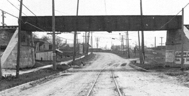
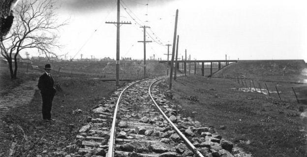
The
undated photo above right
showing the TE passing
beneath the Katy railroad on the south side of Hillsboro was taken by William "Frank" Rogers.
The
photo was published electronically on July 8, 2020 in an article from the official blog of the Plano Conservancy for Historic
Preservation. The
article discusses Rogers' photography of the TE, but its commentary about
this photo concludes with "In the distance, the tracks pass underneath a
Texas and Brazos Valley Railroad trestle."
(emphasis added, the 'T' was for Trinity, not Texas!)
Perhaps the author did not realize that the TE passed under both the
T&BV and the Katy on the south side of
Hillsboro. The photo shows the Katy bridge with Rogers' camera facing
north from a location southwest of the bridge. Note rooftops, utility poles and
towers beyond the left fill toward downtown Hillsboro, details that would not
appear if this photo faced south into the rural landscape outside of Hillsboro.
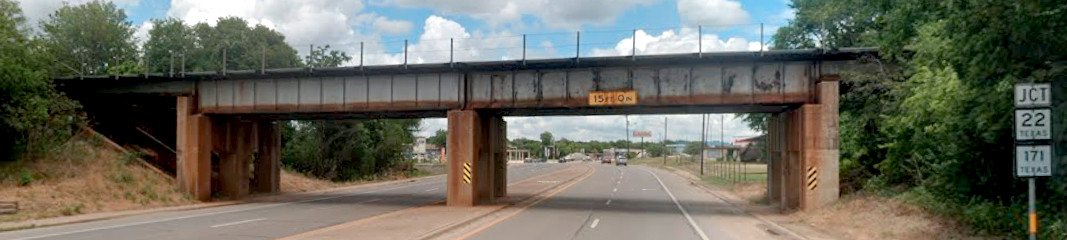
The Katy bridge has been replaced by a newer one (below,
Google Street View, June, 2026, looking northeast) and the right-of-way beneath
it is now a highway, not the TE.
Above Left: This 2023
Google Earth image has been annotated to show the paths of the TE, Katy and T&BV
(B-RI) on the south side of Hillsboro. South of the TE / T&BV crossing (note
purple bridge abutments added to depict the bridge that no longer
exists) the former TE right-of-way curves southwest to become Abbott Ave. which
passes beneath UP's former Katy tracks. This is the same curve visible beyond the bridge in the photo
further above showing the TE making a southwest turn from the roadway
while S. Waco St. continues ahead and curves to the left
(southeast.) The satellite image reveals that south of the curve into Abbott
Ave., the remnant of S. Waco St. has been relegated to
secondary status. Frank Rogers' camera would have been located at the bottom left corner of this
image looking generally north.
Above Right:
This annotated 1938 aerial image ((c) historicaerials.com) shows a similar view
on the south side of Hillsboro. The last segment of the B-RI (T&BV) through
Hillsboro was abandoned (to Hubbard) in 1935, and this image suggests that the
right-of-way had been cleared (or such operations were underway) by 1938. The
red arrows show significant disturbed earth along the right-of-way consistent
with removal of the earthen approaches and the T&BV bridge over S. Waco St. If the approaches were intact, shadows cast to the north
should be apparent, but none are present. This contrasts with the obvious
shadows produced by the Katy's earthen fills (yellow and orange arrows) leading
to its bridge over the TE. Comparing the Katy fills, the westerly fill (orange arrow) has
a shadow that tapers off over a longer distance than the easterly fill (yellow
arrow) which appears shorter and more pronounced. This is consistent with Frank
Rogers' photo
showing the larger east (right) and smaller west (left) fills.
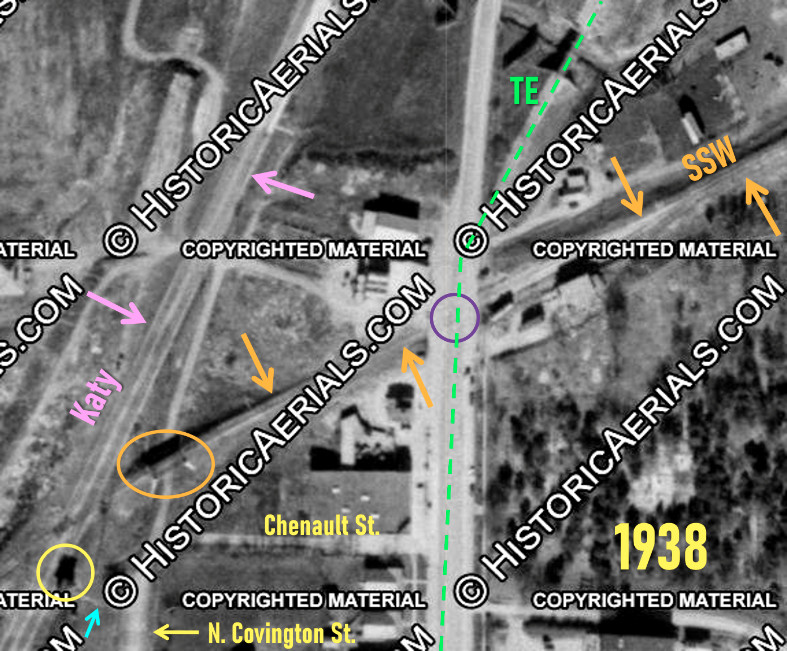
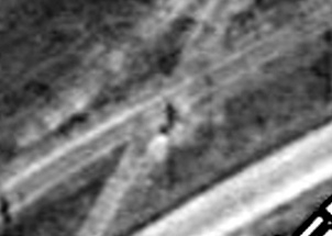
Above Left: This annotated
1938 aerial image ((c)historicaerials.com) shows the tracks near Tower 44
(yellow circle.) Note the footpath (blue arrow) used by operators to access the
tower from N. Covington St. The Cotton Belt (orange arrows) entered Hillsboro on
a southwest heading, crossing the TE at grade on Waco St. (purple circle), a
location that was not interlocked because the TE tracks were on a vehicular
roadway. Automated grade crossing signals with lights and bells had been
developed (and used in Texas by 1933) to warn vehicles of approaching trains,
and this was deemed an acceptable safety system for the TE where its tracks were
on a roadway. Whether grade crossing signals were implemented here is
undetermined. TE trains were always moving slowly here anyway since the interurban
station was only a quarter mile south, hence the TE may simply have stopped
before crossing the Cotton Belt tracks. Near the Katy
tracks, the Cotton Belt had a bridge (orange oval) above a roadway that
appears to be an extension of N. Covington St. north of its intersection with Chenault St. (an extension that no longer exists.) This aerial image was captured
after the T&BV (B-RI) was abandoned through Hillsboro in 1935, hence its
former right-of-way beside the tower is difficult to discern.
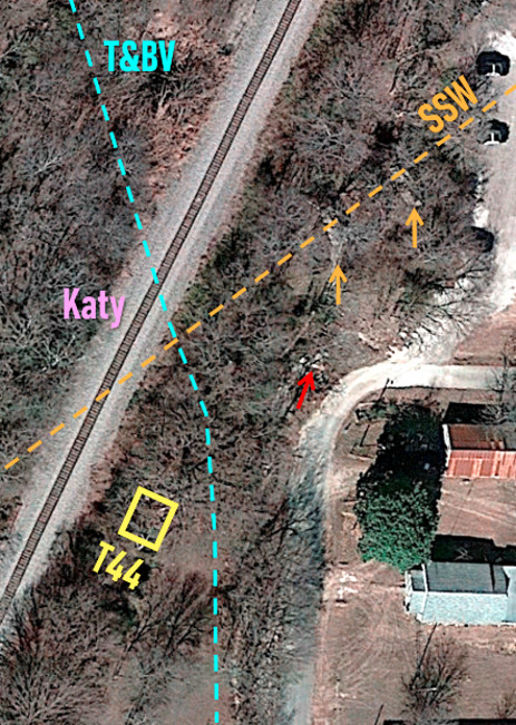
Above
Right: This 2022 Google Earth satellite view of the immediate
vicinity of the site of Tower 44 shows there is now only a single track rail
line. This is in stark contrast to the Katy double tracks visible in Barriger's
photos. It appears that the abutments for the SSW bridge (orange arrows,
corresponding to the orange oval at left) may have survived, buried in the dense
foliage that now occupies this area. Another bridge abutment (red arrow) was
captured amidst the foliage by
Google Street View near
where N. Covington now makes a right-hand turn into Chenault St. The
purpose of this abutment and whether it was railroad-related is undetermined;
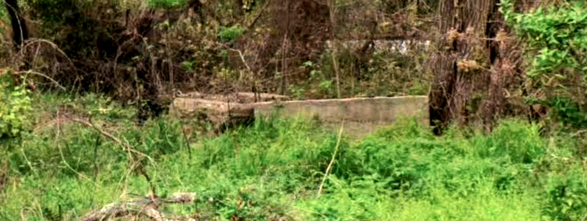
field investigation would be valuable. Below:
Did Google Street View (March, 2023) capture the foundation of Tower 44?