Texas Railroad History - Tower 31 and KCS Tower - Beaumont
Tower 31 - A Crossing of Texas & New Orleans Railway and the Kansas
City Southern Railway
KCS Tower - A Control Tower at the Neches River Bridge

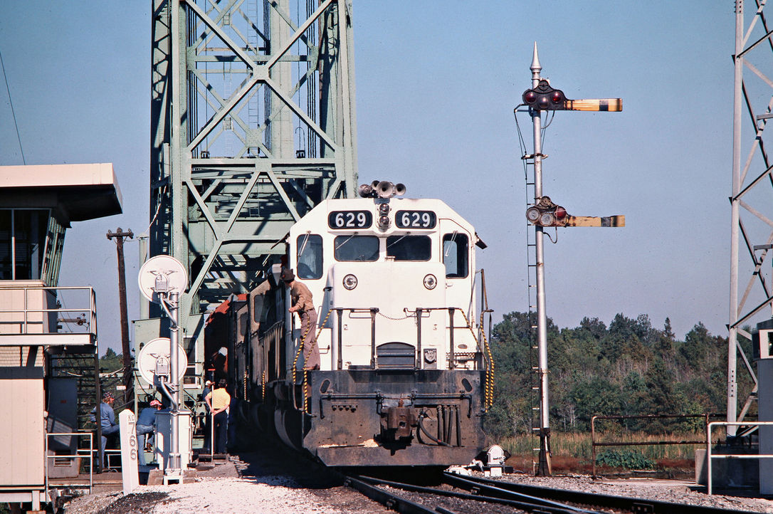
Above: Absolute proof that
this is Tower 31 is lacking, but the circumstantial evidence is overwhelming.
The photo was taken in the late 30s or early 40s by John W. Barriger III from
the rear platform of his business car on a Kansas City Southern (KCS) train.
This much is known because the photo is identified as "KCS 23" in the collection
of the John W. Barriger III National Railroad Library. Positively identifying
this tower would be easy if the white placards visible on two sides of the tower
were readable, but unfortunately, they're not. Yet, they still reveal a valuable
clue: this tower is definitely in Texas because Texas numbered its interlocking towers.
Rectangular white signs with black numbering posted on the rail-facing sides
were universally used as tower number identifiers
(and might have been a specific regulatory requirement.) More
significantly, this tower is clearly a Southern Pacific
(SP) tower because its design is common to many other SP towers in Texas (e.g.
Tower 81, Tower 139,
Tower 21, Tower 30,
Tower 73, etc.)
So...was there a location in Texas with an SP tower at an acute angle crossing
of KCS and SP tracks? Yes. Tower 31 was located at such a crossing immediately
east of the railroads' Neches River bridges at Beaumont. But since we don't
know for certain where the tower sat in relation to the diamond, which direction
is Barriger headed? If he were headed out of Beaumont, we might expect a
substantially different view in the distance since he would be looking back at
the river bridge about a mile away. There were no crossings between the tower
and the bridge, yet there appears to be something
man-made on both sides of the tracks in Barriger's view. This and other evidence compels the conclusion that his train is headed
into Beaumont on a southwest heading, hence the photo looks northeast and the
tower is located on the north side of the diamond. Barriger took the photo that
precedes this one at Tower 28 on a southbound train
at dusk. The implication is that Barriger left
Texarkana headed south on
the KCS main line, passing Tower 28 almost immediately. After traveling through Shreveport and DeQuincy, Louisiana
on the KCS overnight, the
train passed Tower 31 as it neared Beaumont the next morning. The photo appears
to show a well-worn path to reach the tower from the south side of
the diamond, opposite the tower. Access to this site historically has been from
the south (to avoid the swamp north of the crossing). The highway back to Beaumont was to the
north, hence the need for the road crossing visible 0.3 miles in the distance. There is no evidence from satellite or historic aerial imagery
to indicate that there was ever any access to the tower from the north. Barriger is nearing KCS' Neches River bridge where he will cross into Beaumont. The track to the lower left corner leads to SP's Neches River
bridge a quarter mile further upstream. Note that some of the windows appear to be open, implying the
tower was occupied. Why wouldn't it be? The answer is...Tower 31 was converted to an automatic
interlocker on August 20, 1937 and the tower was presumably unmanned most of
the time after that date (hopefully with the windows closed!) Open windows would tend to
suggest that this photo was taken prior to that conversion. Neither the fate of the tower building nor
the date it was removed are known. Below: Next
after the above photo in Barriger's sequence is this shot taken as his train
passed a KCS passenger train, the Flying Crow, which operated between Kansas
City and Port Arthur, with a stop in Beaumont.

"Texas & New Orleans Railroad" was the new name adopted on Christmas Eve, 1859
by the Sabine & Galveston Bay Railroad and Lumber Co., a railroad chartered in
1856 to serve southeast Texas lumber interests. By May, 1861, the "T&NO" had
connected Houston with the town of Orange using wide (5' 6") gauge construction.
After the Civil War, the complete line between Houston and Beaumont was
rebuilt to standard gauge and later extended to Orange in 1876. Numerous disruptions caused by
flooding, washouts, bankruptcies and corporate restructurings delayed the
completion to New Orleans; a train finally made the trip all the way from Houston in 1880.
In the course of financial reorganization, the T&NO was sold to Southern Pacific
(SP) and became SP's primary operating company in Texas and
Louisiana. SP's southern
transcontinental "Sunset Route" passed through Beaumont on T&NO's tracks.
In the mid 1880s, Kansas City railroad developer Arthur Stilwell had an idea to
construct a route between Kansas City and a new port he would develop due south on the
Gulf of Mexico. To implement his plan, Stilwell chartered the Kansas City,
Pittsburg and Gulf (KCP&G) Railway, and in 1892, acquired the Texarkana &
Fort Smith (T&FS) Railway.
The T&FS would build and operate the Texas parts of the route south from Texarkana to Stilwell's new
port on the Gulf. In 1896, the T&FS
constructed 24 miles
of track south from Texarkana to the Louisiana state line, and 19 miles north from
Stilwell's eponymous new port, Port Arthur, into Beaumont. In between, the line
went south to Shreveport and DeQuincy, Louisiana, and then turned southwest to
cross back
into Texas at the Sabine River. In 1897, T&FS completed the remaining Texas
construction between the Sabine River and downtown Beaumont, bridging the Neches
River and connecting with the tracks from Port Arthur.
Full service between Kansas City and Port Arthur commenced on November 1, 1897. In
1899, Stilwell lost financial control of the KCP&G and it was acquired in
1900 by the newly chartered Kansas City Southern (KCS) Railway. Because KCS was
a Missouri-chartered railroad not headquartered in Texas, the State of Texas appealed a
1933 Interstate Commerce Commission ruling that
granted KCS permission to merge the T&FS into the parent corporation, notwithstanding Texas law to the contrary. The
Supreme Court
upheld the ruling in 1934. The formal merger occurred in 1943.
In 1905, railroad magnate B. F. Yoakum negotiated trackage rights on KCS from
Beaumont to DeQuincy. Yoakum's Gulf Coast Lines (GCL) owned a railroad that
connected Houston and Beaumont, and another that connected DeQuincy and New Orleans.
The KCS agreement
completed the GCL route between Houston and New Orleans. In Beaumont, the GCL
connected with KCS less than a mile west of the Neches River bridge, a location
that became known as "GCL Junction", a name that persists today. When the GCL
railroads were
acquired by Missouri Pacific (MP) in 1925, MP inherited GCL's trackage rights on
KCS.
SP had its own bridge over the Neches about a quarter mile upstream
from the KCS bridge. Roughly a mile east of their respective bridges, the two
railroads crossed at an acute angle as they were on similar northeast
headings out of Beaumont. Tower 31 was authorized for operation at this crossing by the Railroad
Commission of Texas (RCT) on October 1, 1903 with a 12-lever/12-function
mechanical interlocking plant built by United Switch & Signal Co. RCT officially
listed the tower as a crossing of the T&NO and T&FS railroads "East of
Beaumont". Despite some historical references to Tower 31 as being at "Connell",
the "East of Beaumont" designation never changed through RCT's final published
tower list in 1930. Connell was a community five miles further east, named
for the president of the
Reese-Corriher Lumber Co., G. H. Connell.
RCT documents archived at
DeGolyer Library show that
Tower 31 was converted to an automatic interlocking on August 20, 1937. This was
about seven years after RCT first authorized the use of automatic interlockers
in Texas,
at Plainview and Lubbock.
The specific reasons for Tower 31's conversion are unknown, but it was certainly
a good candidate. Despite being only
a mile and a half from downtown Beaumont, the tower was in a low lying,
undeveloped area where swampy terrain and dirt
roads made access to the tower difficult even in good weather. With heavy rains
that occur frequently in southeast Texas, access to the tower could be almost impossible at times
(except, of course, by rail.) Automating this crossing eliminated the need to
send
operators to the tower. Since there were no interchange tracks between the
railroads, the automatic interlocker would need minimum functionality. The proximity to the bridges and downtown Beaumont meant that
trains passing Tower 31 would be operating at relatively low speeds, mitigating
risk.
In the early 1960s, MP, SP and KCS collaborated on a decade-long plan to
restructure and share their routes through Beaumont, including the use of KCS'
bridge over the Neches River. This plan meant that east of the river, SP trains
would get on (eastbound) or off (westbound) home rails at Tower 31. West of the
river, SP trains would get on (westbound) or off (eastbound) home rails at Tower
74. KCS and MP rails connected at GCL Junction, and MP rails were used between
GCL Jct. and Tower 74. According to RCT documents, revisions to the Tower 31 junction began in July, 1966 when the
automatic interlocker electronics were relocated to KCS Tower at the west end of
the Neches River bridge. This was followed by removing the diamond, adding a
switch and remote control electronics,
and revising the track to connect the KCS switch to the SP main line. Having relocated its downtown
yard to a site west of Tower 74, SP abandoned its
tracks between Tower 32 and Tower 31 in 1967.
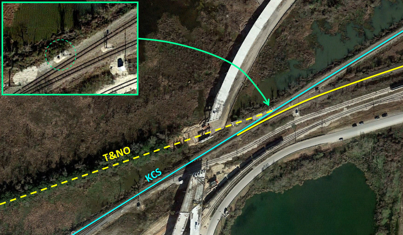
Above: Much has changed at the
site of Tower 31 since Barriger snapped his photo. The green circle shows the best guess as to the
precise location of the Tower 31 structure. As of the Google Earth satellite imagery date, January 5,
2018, a new bridge was
being built over this area to improve truck access to the Jefferson Energy
Terminal located south of the tracks. Below:
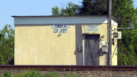
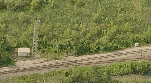
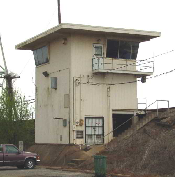
These images c.2004 show a walk-in hut, still named "Tower 31", that housed the
remote-controlled switch
electronics. Jefferson Energy had not yet built
its terminal; the site was a salvage yard accessible to the public. (Jim King
photo, Microsoft Virtual Earth image)
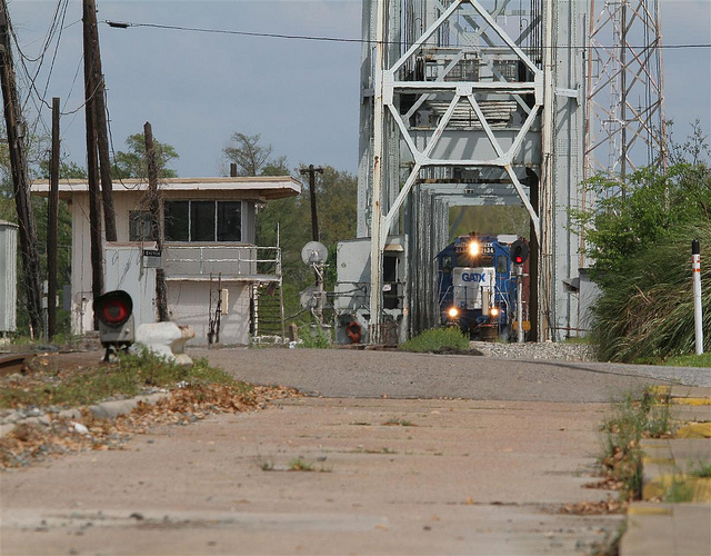
Below: This view of the
Jefferson Energy terminal conveys a
perspective of the tower site in relation to KCS' Neches River bridge. As in
the satellite image above, the road bridge over the tracks near the tower site
(upper left part of the image) remains incomplete. The train is entering the
KCS lift bridge. (Jefferson
Energy image)

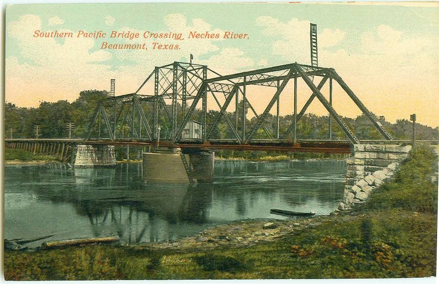
SP
replaced its bridge over the Neches River at least twice: in 1924
and again in 1940. Once SP began sharing the KCS bridge, the 1940 bridge was dismantled. Frank Fertita explains...
|
"The
swing bridge was installed in 1924 to allow taller-masted vessels to pass
up and down the river. As river commerce and traffic increased, the need for a
wider (than 100') span (on either side of the pivot point) necessitated the
replacement with a different type of bridge, and pressure was put on the railroad
to do so. The
Southern Pacific engineering department decided on a
bascule type lift
bridge and contracted with
American Bridge Company to build the structure at a cost of $450,000. The
bridge was installed in June 1940 and at the time was the longest bascule span
(230') in the United States. It was in service until November 1967 and then it
was removed in December 1968 in conjunction with the the major realignment of
the Southern Pacific's trackage through the city." |

Above: This image is extracted from a postcard showing
downtown Beaumont, with both bridges over the Neches River visible. Note the
massive counterweight for SP's bascule bridge on the far side of the river. The
Tower 31 crossing is in the distance at upper left. The date of the photograph
is unknown, likely mid 1960s. (McFaddin-Ward House Museum collection)
Below: SP's 1924 pivot bridge
over the Neches River (Mark St. Aubin collection)

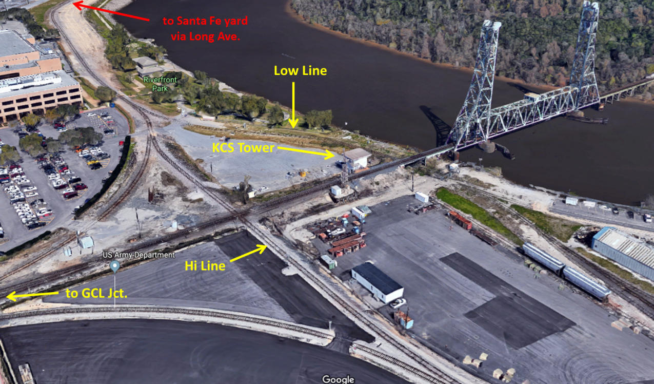
Above: Annotated map
of Beaumont showing numbered towers and other locations (G = GCL Junction, M =
Mariposa Tower, K = KCS Tower.) See the
Tower 32 page for more information about
Beaumont area towers.
KCS Tower
The 1960s project that resulted in the demise of
SP's Neches River bridge caused a substantial increase in traffic over the KCS
lift bridge. As part of this project, KCS constructed a control tower at the west end of
the bridge. Polen Guillot, a retired KCS employee, explains the purpose of the
tower...
| |
It was built in the mid 1960’s as part
of the grade separation project causing SP-MP-KCS to begin operating on
a Joint Track agreement from Langham Road in west Beaumont eastward to the
Neches River Bridge. Prior to the beginning of this system, the Neches River
Bridge was manually operated with Bridge Tender personnel on duty 24/7. The
basement of the tower is for storage. The ground floor is for CTC and
communication operating equipment. The top floor was the Control Tower
office housing the original WWII era CTC board controlling traffic from
South Mauriceville to DeQuincy, La.(CS JCT) A new control board was installed
controlling traffic from Wall St. up to North Vidor. This equipment was our
first venture into microwave telemetry. It took us several years to get the
bugs out of it. The new control board was also hard wired to control raising and
lowering the bridge leaving no need for the Bridge Tenders except one 5-day
maintenance man who kept the many moving parts lubricated and the auxiliary
engine in running condition in case of an emergency. That control was
turned over to other dispatchers’ offices after I retired. The Signal
Maintainers office is still there. The large glass panes were installed at
an angle which, after dark made it impossible to inspect trains because of the
glare from the inside lights. I found a desk top 12” fluorescent lamp and used
it, keeping the office dark. Was able to spot many stuck brakes of eastbound
trains and run down the stairs and bleed them down. Thankfully I never caused a
train to go “in big-hole”. |
KCS Tower

Below Left:
view of the back side of KCS Tower (credit unknown)
Below Right: KCS Tower and bridge. (Mark St. Aubin photo)
Santa Fe also had rail service into Beaumont (which
continues today as Burlington Northern Santa Fe), but they did not cross the Neches River
there. They did, however, serve the port, which meant they had frequent operations near KCS
Tower. Polen adds...
| |
ATSF
(Santa Fe) was “allowed” to keep the Long Ave. connection to the Port of
Beaumont holding yard which, I think was part of this [grade separation]
project. This is also the time a crossing from the holding yard was
installed crossing the KCS main track just east of Main St. where the
double track transitioned into single track. This connection was called
“The High Line” as opposed to the “Low Line” which crossed the KCS under
the Neches River Bridge connecting the dock and warehouses. Previously
port deliveries were made via trackage in South Beaumont. A much older
“head” than I will need to explain those operations. This new operation gave the
KCS, MP and SP access to the new Port Holding yard via the north or west main
with a power switch turnout at Main St. On rare occasions ATSF would derail and
be blocked from the Long Ave. connection. We would run them back to the
ATSF connection via our trackage. We had tacit permission to do this
immediately without calling a pilot engineer or conductor. |
Above: Simulated 3D view of
tracks near KCS Tower (Google Maps)

Last Revised: 2/22/2019 JGK - Contact the Texas
Interlocking Towers Page.