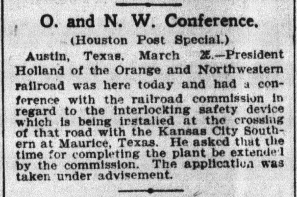
Texas Railroad History - Tower 11 (West Orange) and
Tower 125 (Mauriceville)
The Story of the Orange &
Northwestern Railroad
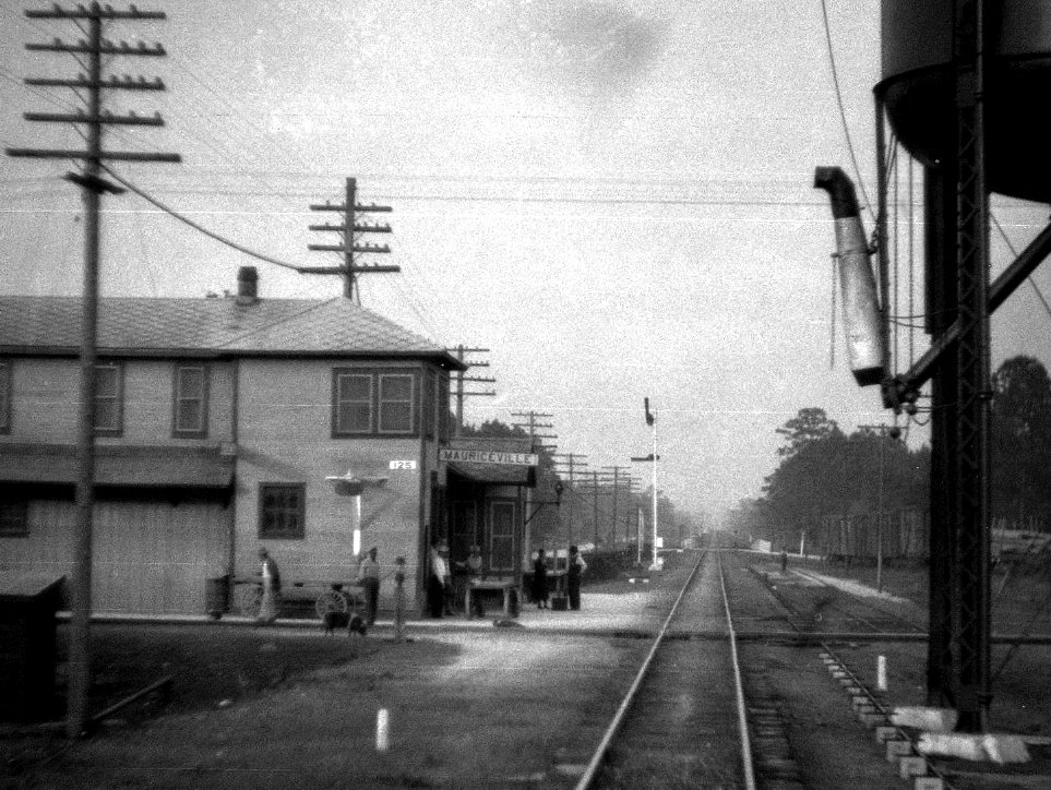 |
Left: This photo was taken by
John W Barriger III from the rear platform of his business car as his
train passed through Mauriceville heading southwest toward Beaumont,
probably in the 1930's. Barriger's camera was facing northeast along the
perfectly straight Kansas City Southern (KCS) tracks toward DeQuincy,
Louisiana. The photo is provided by the John W Barriger III
National Railroad Library, and its administrative identification in the
library indicates that Barriger's car was at the rear of a
Missouri Pacific (MP) train traveling the main line of MP's Gulf Coast
Lines (GCL) subsidiary which it had acquired in 1925. Barriger's train
is exercising MP trackage rights inherited from the GCL to use the KCS
tracks between
DeQuincy and Beaumont. The rights dated back to 1905 and provided a key segment of the GCL route between Houston and New Orleans that
competed with Southern Pacific's Sunset Route.
In the photo, Barriger has
just passed over the Orange & Northwestern (O&NW) Railroad. The O&NW and
KCS tracks crossed at a right angle in an X-pattern, with the depot
located in the quadrant north of the diamond. The O&NW had become a GCL
railroad in 1905, hence it was an MP railroad at the time of Barriger's
trip. The "125" placard on the side of the building announces that the
Tower 125 interlocking plant is located and operated inside, managing
what had become a KCS / MP crossing where MP also had rights on the KCS tracks. |
 |
 |
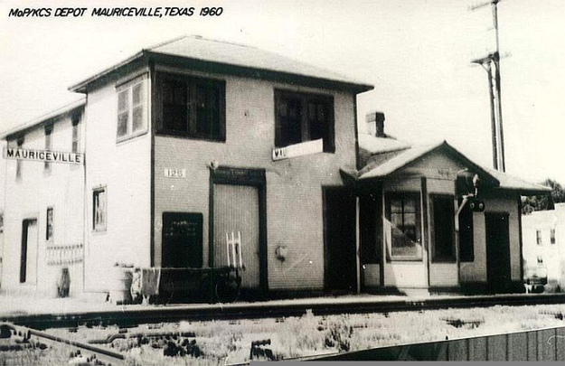
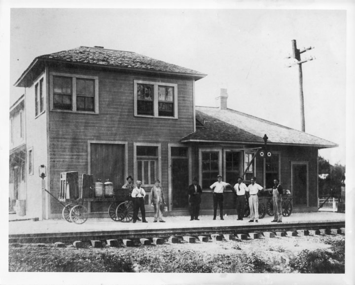
Above Left: 1960 image of
the depot at Mauriceville (H D Connor collection)
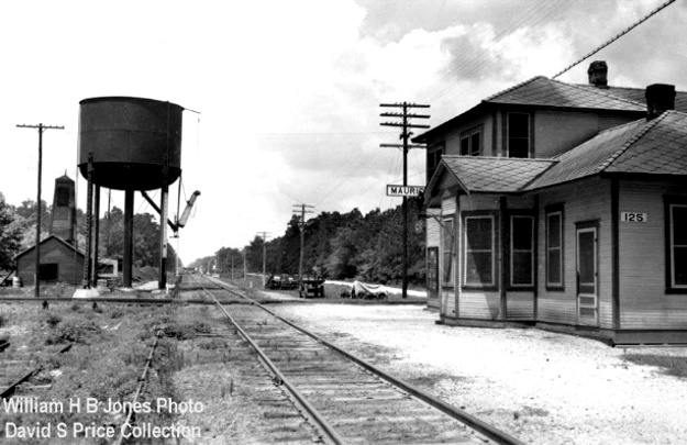
Above Right: Mark St. Aubin supplies
this undated photo of the Mauriceville depot viewed along the KCS tracks toward Beaumont.
Note that the road in the distance behind the depot is now FM 1130. None of
these photos show Tower 11 at West Orange because no photos of Tower 11 have been
found.
The story of the Orange & Northwestern (O&NW) Railroad
begins in 1877 when two
Pennsylvania men, Henry Lutcher and Bedell Moore, toured the massive yellow
pine forests of Louisiana and east Texas. They decided to build a sawmill at
Orange, a town so named because it was in Orange County. The town's original
name, Madison, was dropped due to confusion with another Texas town,
Madisonville. Orange was chosen to be the site of the sawmill because
it was centrally located among the areas to be logged, and only a short, navigable distance from the Gulf of Mexico on the Sabine River, Texas' border with Louisiana. The Sabine offered a means of getting logs to the mill by
floating them downriver from the forests north of Orange. When the mill opened in 1877, Lutcher and Moore named it
the
Star & Crescent Mill; it was the largest sawmill in Texas at the time. The
Texas & New Orleans
(T&NO) Railroad passed near the mill and may have been used during the
mill's construction to bring materials from the port of
Galveston. Proximity to mills in both Texas and
Louisiana combined with T&NO rail service and the Sabine River's outlet to the
Gulf of Mexico enabled Orange to become the
primary shipping gateway for lumber and other wood products along the Gulf Coast.
Prior to the Civil War, the T&NO railroad had been chartered by a lumber company
- a recurring theme in this story - for the purpose of connecting southeast
Texas with the port of Galveston. Three years later, in 1859, the T&NO name was
adopted when the vision for the railroad shifted to establishing a rail line between Houston and New
Orleans. By 1860, tracks had been laid between Houston and
Orange, and as the Civil War commenced, the T&NO briefly became a military supply line.
The condition of the
tracks deteriorated quickly, and in the
post-war years, there was only intermittent service on short track segments for
brief periods. Eventually, the line was rehabilitated and reconstituted into
a new company under the T&NO name. The first post-war train between
Houston and Orange operated in November, 1876. In 1880, the T&NO commenced
scheduled service between Houston and New Orleans through Orange, providing a
critical outbound transportation service for the wood products produced by the
Star & Crescent Mill. By 1881, the T&NO had become attractive to Southern
Pacific (SP) which acquired it to be part of the Sunset Route, a southern transcontinental
line
SP was implementing between California and New Orleans. The T&NO grew to
become a major component of SP's operations in Texas, so much so that in 1920,
SP chose it to become the primary operating company into which other SP railroads in Texas and
Louisiana would be merged.
In 1890, the Lutcher & Moore Lumber Co. was
incorporated to own the Star & Crescent Mill and better organize the expanding
enterprise of the two owners. One component of the mill's operation was a logging tram running
north-northwest from the mill into the nearby forest. The distance and precise
route are unknown, but the main tram line was probably no more than ten miles
long. The tram's path north from the mill required a crossing of the T&NO's
tracks west of Orange, an area later platted as West Orange. The crossing was
uncontrolled; this was a decade before Texas law began mandating safety controls
at grade crossings of railroads. Trams and railroads had coexisted in
east Texas since the 1870s, and many more grade crossings would follow as trams and
railroads continued to penetrate the forests. The crossing at West Orange may
not have been the first such crossing of a lumber tram and a trunk line railroad
in Texas, but it was certainly one of the earliest.
By 1901, Lutcher and Moore had become unhappy with
the T&NO's service. Their mill was generating a substantial quantity of wood
products, but the T&NO was failing to supply enough railcars to satisfy demand
for outbound shipments. Lutcher and Moore believed the solution was to build a rail line thirty miles northwest from
Orange to Buna for a connection with the Gulf, Beaumont & Kansas City (GB&KC)
Railway. This was attractive because the GB&KC had recently been acquired by the
Atchison, Topeka & Santa Fe Railway. Access to Santa Fe's route
network would facilitate competition with the T&NO
for outbound shipments. A secondary objective was to access raw logs from forests farther north. With this strategy, the
Orange & Northwestern (O&NW) Railroad was chartered on January
14, 1901 to build from Orange to Buna. Lutcher & Moore's existing tram road to
the northwest out of Orange was upgraded to become the first several miles of
O&NW tracks. The thirty miles to Buna was completed in 1902. Several mills in
the Orange area and along the route to Buna were served by the O&NW.
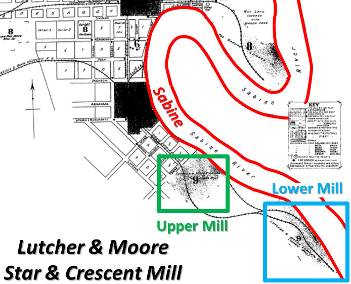 |
Left:
This annotated image from the index of the 1909 Sanborn Fire Insurance
Co. map set of Orange highlights Lutcher & Moore's Star and Crescent Mill
located along a horseshoe bend in the Sabine River on the south side of
Orange. The original mill became known as the "Upper Mill" in December, 1901 when
Lutcher & Moore acquired a competitor, the L. Miller Lumber & Shingle
Co., which they called the Lower Mill.
The Lower Mill had been
owned by Leopold Miller, a prominent local businessman who had moved to
Orange from Germany in 1881. Miller had opened a successful mercantile
business and had become involved in local banking, giving him the
resources to invest in a lumber mill. Soon after selling his mill to
Lutcher & Moore, Miller became the first President of the O&NW, and
both mills were served by its tracks. The Upper Mill was also served by the T&NO.
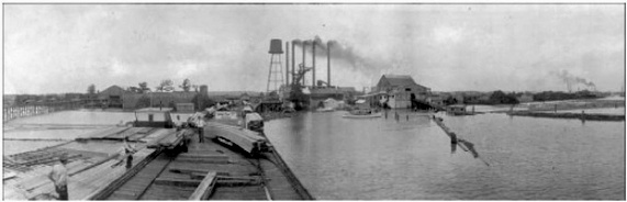
Below: This 1890 view of the Star and Crescent
Mill shows a pier with railcars adjacent to the Sabine River. Logs
floated down the river were
branded upstream so they could be identified to specific mills when
they reached Orange. (credit: Texas
Transportation Archive)
 |
 |
The construction to Buna
required crossing the Texarkana & Fort Smith (T&FS) Railway which had completed
its main line to Beaumont and
Port Arthur from
Texarkana in late 1897. About twenty miles south of
Texarkana, the T&FS tracks entered Louisiana and remained in state south to
DeQuincy, reentering Texas on an almost perfectly straight 47-mile track
running southwest to Beaumont. In 1900, the
Kansas City Southern (KCS) Railway was chartered in Missouri to
acquire various railroad assets out of foreclosure including the T&FS.
Since Texas law required railroads owning tracks in Texas to be headquartered in state, the T&FS
became the Texas-based subsidiary that owned KCS' tracks in Texas.
Where
the O&NW crossed the T&FS ten miles northwest of Orange, the new town of
Mauriceville was founded, named by O&NW President Leopold Miller for his
son, Maurice. Although KCS was a potential carrier for Lutcher and
Moore's mill products, a connection at Mauriceville could not supply
legitimate competition with SP for shipments out of Orange. From
Mauriceville, KCS went southwest to Beaumont and Port Arthur but no
farther whereas Beaumont was only a short distance west of Orange along
T&NO's tracks. Those tracks continued farther west to Houston, and its
parent railroad SP had tracks that continued west from Houston to San Antonio,
El Paso and California. To the north, SP and KCS both served
Shreveport. Although KCS did continue north to Kansas City, it was simply insufficient as a competitor to motivate changes to
SP's railcar allocations or pricing at Orange. Hence, the GB&KC
(Santa Fe)
connection at Buna remained the target.
Left: Since the "125" placard
is not present on the side of the building, this photo at Mauriceville was probably taken before
the Tower 125 interlocking was commissioned in May,
1929. (Mark St. Aubin collection) |
The founding of the O&NW as a means to facilitate trunk
line competition for SP was of significant interest to Benjamin Franklin Yoakum, a
pioneering Texas railroader who wanted to compete with SP across Texas and
Louisiana. Eighteen years after he started his railroading career at age twenty on an
International & Great Northern Railroad survey gang,
Yoakum became the General Manager of the St. Louis & San Francisco ("Frisco")
Railway in 1897. The Frisco was a major carrier in the Midwest and Plains
States, headquartered in St. Louis. By 1905, Yoakum was Chairman of the Executive Committee of the
Chicago, Rock Island & Pacific Railroad, a major Midwest railroad
based in Chicago. Yoakum was effectively Rock Island's Chief
Executive, and he was simultaneously the Chairman of the Board of the Frisco as he attempted to merge the two railroads.
Focusing on the Gulf Coast, Yoakum began to execute a plan to
accumulate and build out a set of railroads collectively known by the marketing
term Gulf Coast Lines (GCL) that would form a continuous route from
Brownsville to New Orleans via Houston.
The GCL was managed by Frisco executives but was owned by a financial syndicate
formed through the St. Louis Trust Co. For a portion of the GCL route from New
Orleans to Houston, Yoakum negotiated rights to use KCS' tracks between DeQuincy
and Beaumont. Since this segment included Mauriceville, Yoakum viewed the O&NW
as a potential source of feeder traffic to the GCL. He bought the O&NW in 1905,
adding it to the GCL and building connecting tracks at Mauriceville.
| The Tap Line Cases |
The founding of the O&NW was a classic example of a
tap line. A tap line was simply a chartered
and incorporated common carrier railroad owned by a
lumber company (or its closely related interests, e.g. management
investors) that moved logs inbound to the mill and wood products
outbound to interchanges with trunk line railroads, while also
serving the population along the route. Tap lines evolved west of the
Mississippi River. The West was larger and less populated, hence it had
longer, but fewer, roads for wagon transportation. With increased distances to move logs to
mills, timber companies found it more efficient to establish
remote camps for logging teams rather than move personnel to and from
the forest each day. This necessitated moving people and supplies by
tram to isolated outposts that might otherwise be inaccessible due to
the lack of roads. As
communities of laborers, their families and enterprising merchants
sprang up around the larger outposts, the tram lines serving these
outposts became essential for basic
transportation.
The western timber companies discovered a major benefit to
chartering and incorporating their private logging trams to become tap lines.
When common carrier railroads exchanged traffic, the revenue
for the entire shipment was split using a negotiated division
rate. As outbound wood products moved over a tap line to reach
connections with trunk line railroads, the tap line received a share of
the total revenue for the shipment, even if the movement was only a
short distance from the mill. This
produced additional income - allowances - to the tap
line's owners. Tap lines with
access to more than one trunk line had leverage to negotiate
higher divisions and allowances by favoring the higher-paying connection.
An allowance paid to a tap line from the shipping revenue on
the output of their owner's mills was, in essence, a "kickback" from the
trunk line, but it was legal. However, by
accepting the benefits of common carrier status, the tap lines
also accepted two significant legal obligations. They had to
offer transportation services to the public without
discrimination, and they had to set public tariffs
and charge fees for their services.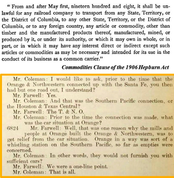
It seems obvious that a railroad would charge a fee for its service,
but logging trams owned by lumber companies had always hauled logs for
free; a tram was just
another component of the mill's operations. Private trams
were not common carriers, but tap lines were. If a tap line was undercharging (or not charging) their
mill to move inbound logs, then other nearby mills wanted the same rail
service at the same price, and therein lay the origin of a major dispute
heard by the Interstate Commerce Commission (ICC). The ICC investigation
began in 1909 covering more than one hundred tap line railroads in
Texas, Arkansas, Louisiana and Mississippi. The ICC ruling, issued in
April and May, 1912, analyzed the details of each of the tap
lines and found that thirty of them did not qualify as common
carriers. In the ICC's view, the service each of these tap lines
was providing was a plant
service, an inherent part of processing raw timber into products, rather than a true transportation service.
Hence, they were not common carriers and therefore ineligible for
allowances. The ICC ruling forbid trunk
lines from making such payments to these tap lines.
The
ICC ruling was appealed
to the U. S. Commerce Court, a Federal Court created
for the purpose of hearing appeals of opinions and orders issued by the ICC.
[The Commerce Court was short-lived, created by the
Mann-Elkins Act of June, 1910 and abolished by public law
in December, 1913.] The Commerce Court determined that the
ICC's
ruling against the thirty tap lines needed to be remanded to be
reevaluated under a proper reading of the law. The
ICC's legal analysis had concluded that tap lines converted from private logging trams
and still owned by their lumber companies failed to meet the
criteria for common carriers, regardless of any evidence
to the contrary. The Court ruled this to be legal error, pointing out that the
Commodities Clause of the Hepburn Act of 1906 (above
right) had specifically exempted "...timber and the
manufactured products thereof..." from the law's general
prohibition on railroads transporting products in which they had
any direct or indirect financial interest (items needed
by the railroad to function,
e.g. fuel, water, supplies, employees, etc. were also exempted.) The ruling of the
Commerce Court was appealed to the U. S. Supreme Court. The case
was heard in April, 1914 and the Supreme Court affirmed the Commerce
Court ruling in its entirety in an opinion issued the following month.
Below Right: The ICC ruling did not affect
the O&NW; it was an undisputed common carrier trunk line, part of the GCL since 1905.
But O&NW management did appear as
witnesses, called to testify before the ICC at various hearings. In this example,
ICC Examiner Coleman questioned Mr. Farwell, an O&NW executive. |
By early 1906,
Yoakum had extended the O&NW 28 miles north from Buna to Newton, a small community deep in the forest
near the Louisiana border. The extension appears to have served two purposes.
The forests between Orange and Buna were beginning to thin out, hence
the extension reached additional timber needed by the mills at Orange. And
since Santa Fe's tracks at Buna continued north to Kirbyville, Jasper and
beyond, there were few remaining towns of any size within a reasonable distance
of the GCL at Mauriceville that did not already have rail service. Newton was
the exception, having had a Post Office since 1853 and a private college since
1889. It was the county seat at the geographic center of Newton
County which had over 7,000 residents in the Census of 1900. Presumably, Yoakum saw Newton and the surrounding county as ripe for population
growth and increased commerce that the O&NW would stimulate.
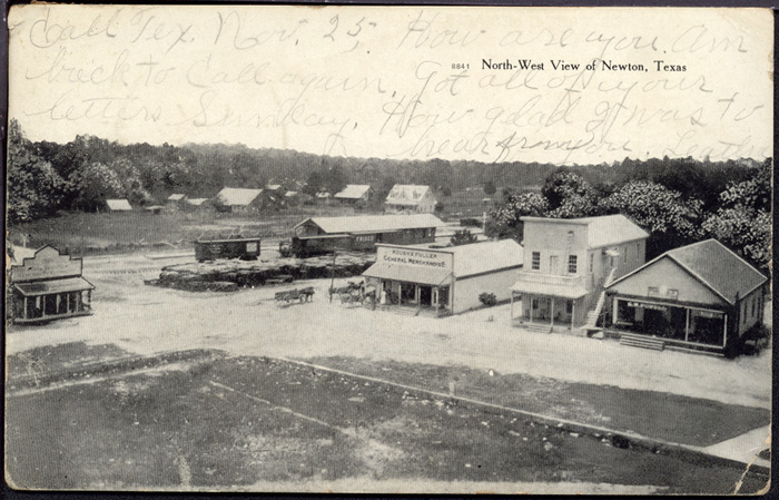 |

Left:
This 1907 view of Newton is a post card (Curt Teich & Co., Chicago) from the Murry
Hammond collection, courtesy of the Texas Transportation Archives.
Consistent with Yoakum's acquisition of the O&NW, a Frisco boxcar can be
seen directly adjacent to the O&NW depot in the background.
Right: This 1913 map from the Louisiana Railroad
Commission (with green and red ink lines hand-marked for an unknown purpose)
shows the O&NW route between Orange and Buna with various locations
identified. Near the Sabine River, the southern part of the Orange, Call
& Pine Belt (OC&PB) private tram is also shown. Despite its appearance
on a 1913 map, this narrow gauge tram operated in 1898-99 and not much
beyond that, so far as is known. |
The tram database of the
Texas Forestry Museum includes this
personal recollection of the O&NW:
W. E. Merrem, a Houston Oil
Company executive, remembered that the road �was in bad shape. I rode it a
number of times before we had automobiles and decent roads. It was really
something to ride. They had no ballast on the roadbed, and it was so dusty you
couldn't see from one end of the car to the other. It mostly handled sawmill
products, which they picked up at Newton.�
 |
Left:
Historic rail lines in the vicinity of Orange are shown on this
map, but for no particular date.
Only three track segments on the map are currently abandoned: the
T&NO northwest of Beaumont, the entire Sabine and Neches
Valley (S&NV), and the O&NW north of Buna (to Newton.) The Santa
Fe line southwest from Beaumont becomes abandoned about ten miles out of town.
Although 49 miles
of former O&NW tracks north from Mauriceville to Newton was
abandoned in 1963 by Missouri Pacific (MP), successor to the GCL, the
right-of-way (ROW) between Mauriceville and Buna was acquired shortly
thereafter by the Sabine River & Northern (SR&N) Railroad. The
SR&N had begun a construction project to serve paper mills at Mulford and Mauriceville. The track to Mulford was
built by SR&N in 1966, five miles north from the T&NO at
Echo.
In 1967, track-laying continued north and west from Mulford to
Mauriceville, along with new tracks laid to Buna
on the purchased ROW. In 1990, the SR&N opened an 8-mile line
west to Evadale from a new junction on its existing track eleven
miles north of Mauriceville.
The SR&N is owned by
Temple-Inland, a packaging and building products company traditionally
based in Diboll, Texas that became a
wholly-owned subsidiary of International Paper in 2012. The SR&N functions like the
classic "tap line" railroads of the early 1900s, i.e. a common
carrier railroad founded by a wood products company used for moving raw
materials to mills and finished products to trunk line interchanges. For the SR&N, these interchanges are at
Evadale, Mauriceville and Echo.
The S&NV was
chartered in 1921 as a tap line for the Peavy-Moore Lumber Co. which had
a sawmill at Deweyville. The S&NV had connections to the KCS south of
Deweyville and a connection to the O&NW at Gist. The sawmill burned in
1944 and the S&NV was abandoned the following year.
Only KCS and the
SR&N still operate under the names shown on the map. The T&NO and the GCL lines,
including the O&NW line south of Mauriceville,
are now part of Union Pacific (UP). The Santa Fe lines are now
part of Burlington Northern Santa Fe (BNSF) except the line
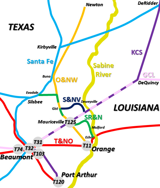
between Kirbyville and DeRidder operated by the Timber Rock Railroad.
The interlockers in this area identified by tower number were at
Beaumont (Towers
31, 32,
74 and 103),
Port Arthur (Tower 120),
Mauriceville (Tower 125) and West Orange (Tower 11.) |
Texas law requiring interlockers or gates for safety
purposes at grade crossings of different railroads took effect in 1901. Soon,
the Railroad Commission of Texas (RCT) began issuing orders prioritizing the
crossings to be interlocked and the procedures for obtaining final approval for
each interlocking plant installation. Low on the priority list (or more
precisely, "not even on the list") was the issue of how to handle the many
crossings throughout east Texas where a lumber tram crossed a trunk line railroad. Such crossings had existed for
years and the railroads had accommodated them without issue since they were a
necessary part of east Texas lumbering, an industry that provided profitable
business to the railroads. Some lumber trams brought logs to a siding for a railroad to haul
to the sawmill, but the larger lumber companies had vast networks of tram lines
and they sometimes needed to cross a railroad for no other purpose than to
simply get to the other side.
Were these crossings somehow exempt from the
interlocker law since they involved a tram instead of two common carrier
railroads? It would take many years for RCT to sort out the
answer, yet the safety issue was no different. To the extent there was any
attempt by RCT to begin enforcing interlocker requirements for tram crossings,
it appears to have begun with Tower 110 at Dayton
in 1917 and Tower 111 at Trinity in 1919. In the
1920s, a few additional east Texas locations were interlocked:
Hyatt, Devers,
Cruse,
Fullerton, along with two trunk line crossings by the Grogan-Cochran Lumber Co. near
Magnolia in the 1930s. Like other such crossings, the tram that ran
northwest from the Star & Crescent Mill was not interlocked where it crossed the
T&NO in West Orange. Yet, when the tram morphed into the O&NW in 1901, it became
one of the first crossings to be interlocked as a result of the new law that
took effect that same year.
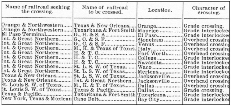 |
Left: RCT's 1903 Annual Report (covering the 1902
calendar year) included a table of priority crossings to be addressed.
It did not list the five interlockers approved in 1902; all subsequent
reports listed all active interlockers by tower number plus those "Under
construction." The first two entries in this table were for the O&NW
crossings at Orange and "Maurice".
The first
column identifies the railroad seeking
the crossing, a detail omitted from all subsequent reports. It appears
that the "seeking" railroad was not simply the second railroad at a
crossing because the entry for Texarkana conflicts with that rule. The
difference in the Character of crossing
between "Grade crossing" and "Grade interlocked" is undetermined; none
of these crossings were interlocked at the time. It is also unknown
whether the "seeking" railroads had actually made a request to RCT for
interlockers at the reported locations; it seems doubtful so soon after
the 1901 law took effect. Note that the law also required RCT
approval for grade-separated "Overhead crossings". The
composition of this table is also confusing because some
interlockers were approved quickly in 1903, e.g.
Waco, "College",
Navasota
and Orange, while others were delayed for many years, e.g.
Mertens (c.1935) and "Maurice" (1929). |
RCT commissioned Tower 11 for operation at the T&NO / O&NW
crossing at West Orange on June 27, 1903. It housed a 12-function mechanical
interlocker,
the minimum for a basic crossing consisting of a distant signal, a home signal
and a derail in each of the four directions. RCT documentation states that the
Tower 11 interlocker was installed by the T&NO but does not identify which
manufacturer built the plant. A table published by RCT in 1907 lists an average
of 21 movements per day past Tower 11 for the twelve months ending June 30,
1906. Although no photos of Tower 11 have surfaced, it is known to have been a
manned tower (as opposed to a cabin interlocker) because "Train Order Office Hours" of 7:00 AM to 11:00 PM were
published for Tower 11 in a 1920 SP timetable. Tower 11 was almost certainly a 2-story
tower similar to other SP towers in Texas, e.g. Tower
31 located twenty miles west near Beaumont.
Through the end of 1929, Tower 11 continued to be listed
in RCT documentation as a 12-function mechanical interlocker, but RCT's final
published comprehensive interlocker list dated December 31, 1930 reported Tower 11 as an
8-function automatic interlocker. A letter in the RCT archives at
DeGolyer Library, Southern Methodist University, issued by SP on June 29, 1931
notified RCT that the conversion of Tower 11 to an automatic interlocker had finally been
completed. That this fact somehow was reported in a table dated December 31,
1930 is a bit problematic. There are two additional 1931 dates in this table
(for Lubbock and Plainview)
which may indicate that the table was published later in the year, or perhaps
the table was complied to anticipate the completion of authorized work.
The conversion of Tower 11 to an automatic plant coincided with the end of operations at the
Star & Crescent Mill, which closed in 1930. O&NW
movements pasts the tower would be reduced since it was no longer carrying
inbound logs nor outbound wood products for the Star & Crescent Mill, but the line remained operational by MP
and continued to serve other mills. The reduction to eight functions undoubtedly reflects elimination of the derails.
In an order issued May 1, 1930 for Tower 142 in
Plainview, RCT stated that "...derails have caused as many or more
accidents as they have prevented and the elimination of same from interlocking
plants of all kinds has been recommended for the past several years by the
American Railway Association...". Interlockers installed
after May, 1930 were not likely to have had derails.
Right: The
Houston Post of March 26, 1904 reported on a meeting the
President of the O&NW attended at RCT headquarters in Austin. As noted
above, RCT's Annual Report published at the end of 1902 included a table
of priority locations for interlocker installations which included the
two O&NW crossings, at Orange and "Maurice." The details of the meeting
are unreported, but the O&NW apparently
obtained permission for additional time to install an interlocker at
Maurice.
It does not seem unusual that the O&NW was
successful in obtaining permission from RCT to delay the installation of
the Mauriceville interlocker. That the delay lasted twenty-five years
does seem odd! To add to the mystery, the fact that the Mauriceville
interlocker was number 125 suggests that the proposal to initiate
engineering design and installation of the interlocker was not submitted
to RCT until the latter months of 1925. This is deduced from the fact
that a tower number was assigned by RCT when the initial interlocker
application was made. Towers 124 and 126, both in
south Fort Worth, were installed in the
latter half of 1926, and a typical implementation schedule was eight to
twelve months. Stranger still, Tower 125 was commissioned on May 2, 1929,
nearly three years after Tower 126 became operational in June, 1926.
Based on the March, 1904 meeting in Austin and allowing a year of delay
and another year to propose, build and install a Mauriceville
interlocker, it should have been commissioned around April, 1906, not May, 1929. The reason for this enormous cumulative delay
is undetermined. It should be noted, however, that the 1929 date can be
traced to MP's efforts. MP and its subsidiaries had fifteen interlockers
commissioned by RCT in 1929 at rural locations, undoubtedly the result
of a corporate directive. |
 |
Tower 125 was listed by RCT as a 10-function mechanical
cabin interlocker. In general, cabin interlockers were so named because the
plant and its controls were housed in a small, trackside hut ("cabin") with a
locked door. The controls were operated by crewmembers from trains on the less
busy line, with the signals otherwise set for unrestricted movements on the
busier track at all times. Photographic evidence (see top of page) indicates
that the Tower 125 interlocker and its controls were installed inside the
Mauriceville depot rather than in a trackside cabin. Rather than the
traditional twelve functions of a minimum standard interlocker, cabin
interlockers typically had fewer functions because the two distant signals on the less busy line, in this case
the O&NW, were omitted. There was no need
for a distant signal to
warn O&NW trains to stop at the crossing because all
O&NW trains were required to stop at the crossing. A fixed sign at the appropriate distance in
each direction provided sufficient notice to
O&NW locomotive crews that they were approaching the crossing and needed to stop so that the signals could be set
by hand to allow them to cross the KCS tracks. [At Mauriceville, a depot employee
most likely lined the signals for O&NW trains
rather than a crewmember.] After a suitable safety delay enforced by the
interlocker, lining the O&NW home signal to grant a PROCEED condition would automatically issue a
STOP indication on the home and distant signals on the KCS
tracks and set the derails. The signals and derails would be reversed manually once the O&NW train had completely crossed
the diamond. Derails were still required because Tower 125's commissioning was a
year prior to RCT's Plainview order.
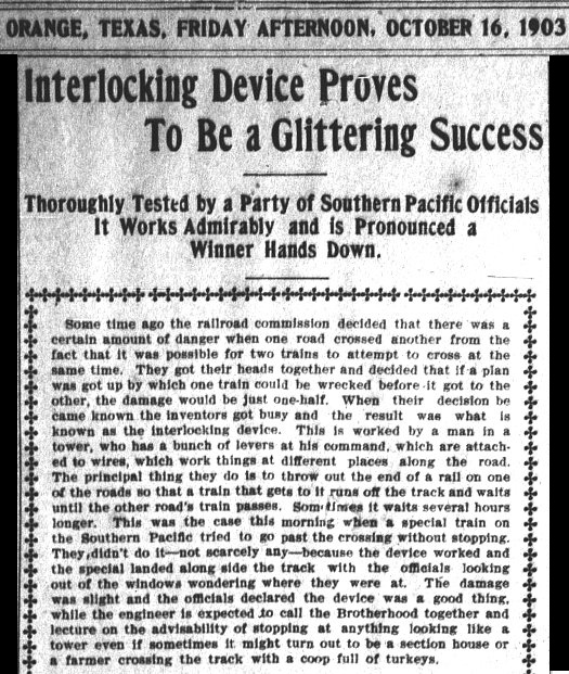 |
Left: The
Tower 11 interlocker made front page news in the
Orange Daily Tribune of
Friday afternoon, October 16, 1903 by derailing a locomotive, thereby
fulfilling its safety mission. The mention of a "special train"
along with a
headline indicating the interlocker was being "Tested by a Party of
Southern Pacific Officials" suggests that the train was
intentionally testing the derail. It is unsurprising that such
tests might have occurred in the early days of Texas interlockers and
they were apparently worthy of Page One news, at least in a town the
size of Orange.
Below:
A Google Earth view from 2019 shows the O&NW ROW still in use
north of the Tower 11 crossing. To the south, 0.75 miles of track
was abandoned in 2000 eliminating the diamond. Historic aerial imagery
and topographic maps indicate that the apparent ROW southwest of the crossing
was originally a levee but later (post-1959) had rails that remained
visible as late as 1983. The ownership and purpose of those rails is undetermined.
 |
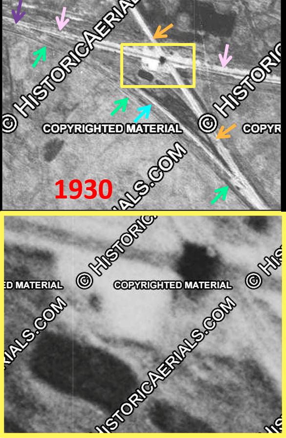 |
Left: This
1930 aerial image ((c) historicaerials.com) of the Tower 11 crossing is
difficult to interpret due to the lack of resolution. The O&NW (orange
arrows) [by this time, owned by MP] and the T&NO (pink arrows) cross within
the yellow rectangle, but what to make of the magnified scene of the
crossing (lower image)? Telltale shadows combine to produce a vague
outline of what appears to be a structure with a white roof possibly
having an angled wall on the southwest side, or more likely an overall L-shaped
structure. What appears to be a small dark shadow covers the crossing
diamond, but the shadow does not have a clean, rectangular shape.
Instead, it looks as if it might be cast by some sort of uneven
structure atop the northeast corner of the building -- if it is a
building.
Was this some kind of tower facility that had been
integrated into a building? The outline of the building -- if it is one
-- could resemble an L-shaped depot or railroad office. There could have been a West Orange
depot at the crossing, but there is no mention of one in T&NO
timetables. A 1918 T&NO Employee Timetable (ETT) has a milepost entry
for the O&NW crossing, but the nearest depot is more than two miles
distant in either direction. And what to make of the dark rectangle
beside the building. It doesn't look like a shadow, perhaps a pit or a
stack of dark material, but it has a similarly "shaded but less dark"
path leading back to the O&NW right-of-way. Perhaps this was a roadway
for workers to reach the facilities?
Elsewhere, a curved linear
area (blue arrow) appears to connect back to the O&NW tracks and
possibly has a connection to the T&NO at the other end (purple arrow.)
The lack of image detail makes this speculation at best. A second curved linear area (green arrows) looks
more like a levee. Although it appears track-like in places, it does not
seem to have a clear connection to the known main line tracks at either
end. The next available aerial imagery is from the 1950s, by which time
all of this detail has disappeared and nothing obvious is visible except
the levee -- if it is one. |
 |
Left: This recent annotated Google Earth image shows the location of the
Tower 11 crossing in West Orange where the former O&NW line continued
northwest toward Mauriceville. The former T&NO line runs mostly horizontal
across the image from west (toward Beaumont) to east (toward New Orleans). The
Lutcher & Moore mill site was farther east at the bend in the Sabine. RCT
drawings on file at DeGolyer Library at SMU indicate that Tower 11 was located
on the southwest side of the crossing. As the 1930 imagery shows, there was
definitely something in that quadrant. |
 |
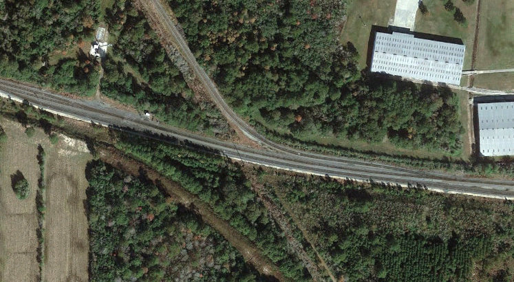
Left: This Google
Earth image shows the Tower 125 crossing at Mauriceville. North of
there, MP abandoned the tracks to Buna and beyond in 1963. The
SR&N bought the abandoned ROW and laid new tracks to Buna in 1967, the
year after construction of its line from Echo had begun. The Tower 125
interlocker was located in the depot on the north side of the crossing.
A 1956 KCS employee timetable listed the Mauriceville crossing as
"Interlocked" but did not include "(Automatic)" as it did for some of
the other crossings listed. It's likely that the crossing was converted to an automatic interlocker by the mid-1960s. A connecting
track in the
southern quadrant probably existed in the Yoakum era, and it appears on imagery
from 1930 until it was removed between 1996 and 2004. Similarly, a
connecting track in the eastern quadrant that probably dated to the
Yoakum era is visible on imagery from 1930 to 2018, but is not present
on 2020 imagery. |
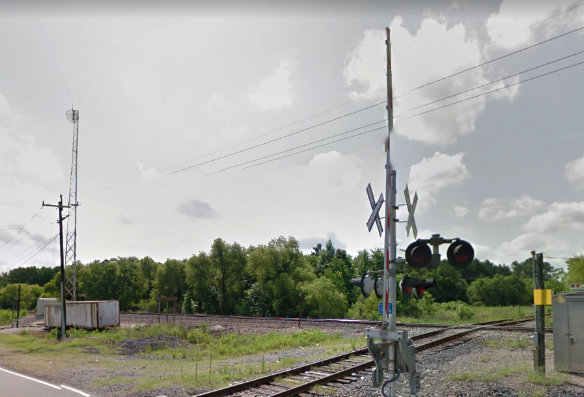
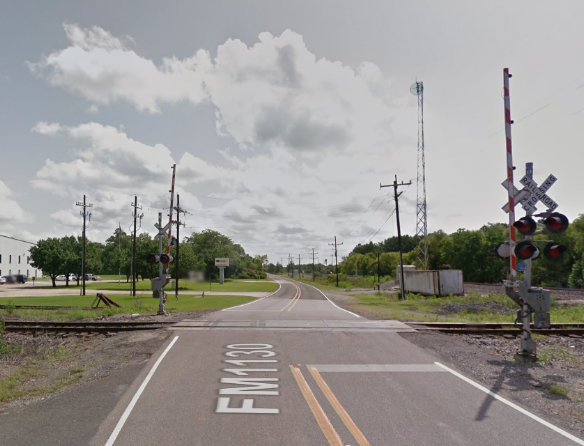
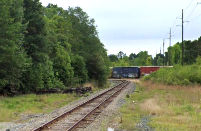
Above: Looking
south-southeast, the Mauriceville depot fronted the north side of the
KCS tracks, between the diamond and the trailer.
Above: FM 1130 crosses
the SR&N and runs behind the former depot site. (Google Street View images, June
2015)
|
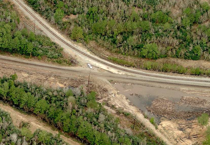
Right: This bird's eye view of the Tower 11 crossing
from c.2005 shows substantially disturbed earth, perhaps in preparation for the
additional track that UP added through this junction. Compare this view with the
satellite view from 2019 farther above. The tower was located approximately
where the utility pole sits southwest of the crossing. The location remains to
be field-checked for evidence of the tower's foundation, but the chances are
slim since it was removed nearly a century ago. |
 |
|
Right: Looking southeast from Tulane Rd. along the former
O&NW ROW, UP's tracks now curve to the east instead of crossing over at Tower 11
as they reach the main track, which is occupied by a UP train. |
 |