Texas Railroad History - Tower 85 - Houston (Baker Street) and
Tower 189 - Houston (Magnolia Jct.)
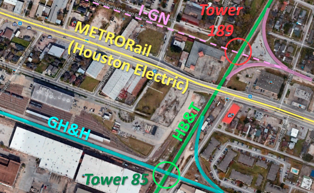
Two Crossings of the Houston Belt &
Terminal Railway South of Downtown Houston

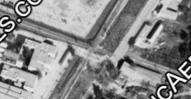
Above Left: Kenneth Anthony
took this photo of the Tower 85 crossing in 1986. The view is south along the
East Belt portion of the Houston Belt & Terminal (HB&T) Railway. Long before
the East Belt materialized, the crossing track was built by one of the early railroads in Texas,
the Galveston, Houston & Henderson
(GH&H) Railway. Above Right: The
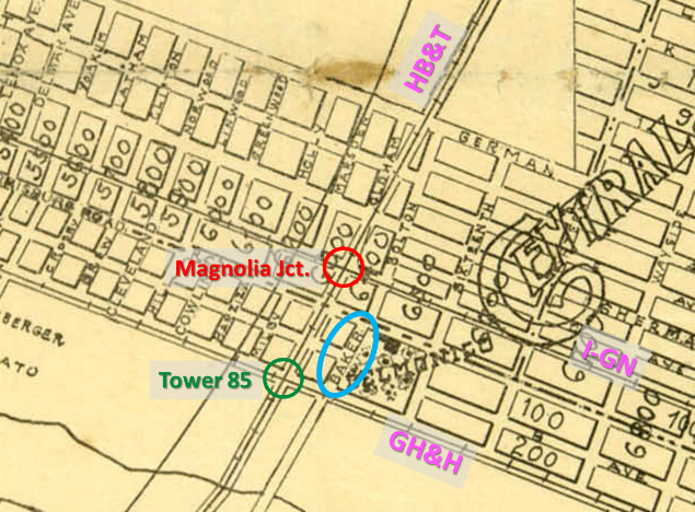
reason the Railroad Commission of Texas began to list the location of Tower 85
(green circle) as "Houston (Baker St.)" in 1927 was to distinguish it
among all of the
towers generically assigned as "Houston". Tower 85 got the Baker Street
postscript because that was the closest street (blue oval) to the tower, as
illustrated by this annotated image from a 1913 Houston street map (courtesy,
Texas State Library & Archives.) Later, Baker St. was renamed 65th St.
and it no longer crosses the tracks (if it ever did - maps of this nature were
often prospective based on a town's plat.) Nearby Magnolia Junction (red circle)
was another crossing of the East Belt, where it intersected a branch line of the
International & Great Northern (I&GN) Railroad.
Tower 85 has controlled a major rail junction in
Houston for more than a century, a crossing of the
Houston Belt & Terminal (HB&T) Railway and the Galveston, Houston & Henderson
(GH&H) Railroad southeast of downtown. The GH&H was one
of the first railroads in Texas, chartered in 1853 to build between Houston and
Galveston, with plans to build north to Henderson in deep east Texas.
Construction was delayed but eventually began at
Virginia Point on the mainland; rails reached
Houston in 1859 (and never went further.) The two-mile long trestle from
Virginia Point onto Galveston Island was completed the following year, just in
time to be used by both sides during the Civil War. For a variety of reasons --
most especially yellow fever quarantines against Galveston Island -- freight
into Houston bound for
Galveston on the GH&H did not always reach the
Island. Sometimes it was off-loaded at Houston
and shipped by barge down Buffalo Bayou to Galveston Bay to be loaded directly
onto ships, bypassing the Galveston wharves. To be fair, Houston shippers were
trying to overcome restrictive policies practiced by the Galveston Wharf Company
that favored Galveston's shippers over Houston's.
As S. G. Reed explained
in his reference tome A History of the Texas Railroads
(St. Clair Publishing, 1941) Galveston's citizens were certain that Houston
was...
...inspired less by fear of the
plague than by a desire to hamper Galveston trade, as the quarantines were
established with regularity every fall when cotton was moving and trade was
best.
After a post-war foreclosure and restructuring, the GH&H
was acquired by rail baron Jay Gould in 1882 who quickly sold it to the
Missouri, Kansas & Texas (MK&T, "Katy") Railway of which he
was President. Since the Katy had no tracks near
Houston or Galveston at the time, Gould directed the Katy to lease the GH&H to the International & Great Northern (I&GN) Railroad, another company
he controlled. In 1888, Gould was fired by Katy stockholders, and five years
later, tracks of the newly independent Katy railroad reached
Houston. The Katy filed a lawsuit to revoke the lease
of the GH&H to
the I&GN. In a final settlement reached in 1895, the Katy sold a half interest
in the GH&H to the I&GN, with each having permanent, unlimited rights to use the GH&H
tracks.
When the I&GN came out of bankruptcy in 1922 free and clear of the Gould
family (and with a new name, the International - Great Northern,
"I-GN") it was soon acquired by Missouri Pacific (MP) and
became fully
merged into MP in 1956. In 1982, MP was acquired by Union Pacific
(UP) but continued to operate under the MP name. Six years later, UP
acquired the Katy and merged it into MP the following year. The GH&H was merged
at the same time because MP now owned all of it: the 50% share inherited from
the Katy and the 50% share it had acquired from the I-GN acquisition in 1925.
The other railroad at Tower 85 was the HB&T, formed in
1905 by four railroads to provide switching services around Houston, including
building tracks to facilitate interchange and erecting a union passenger station downtown. The
four railroads -- the Gulf, Colorado & Santa Fe
(GC&SF) Railway, the Trinity & Brazos Valley (T&BV) Railway,
the Beaumont, Sour Lake & Western Railway, and the St. Louis,
Brownsville & Mexico Railway -- each had a
quarter interest in the HB&T, and each contributed other assets, mostly trackage.
Although Santa Fe's main line
out of
Galveston (to Temple) had avoided a route through Houston
due to the aforementioned service disruptions, by
1883, the Houston economy had become so important that Santa Fe could no longer ignore
it. They built a 26-mile branch that year from their main line at Alvin into downtown
Houston. They also built a yard (eventually known as South Yard) along
this branch approximately two miles south of downtown. About 25 years later,
access to
HB&T's East Belt began near the south end of this yard. HB&T took over
yard operations from Santa Fe and then built New South Yard (Tower
117) directly south of the East Belt connection.
Railroad
Commission of Texas (RCT) records attribute two construction activities to
the HB&T: 8.13 miles in 1907 and 9.74 miles in 1912. This construction produced a
semi-circular belt line around the east side of Houston along with new tracks
north and south out of downtown. While RCT construction records do not provide
dates for specific track segments, RCT's interlocker records show that
Tower 76 was commissioned in 1908. This was a
crossing of the Houston East & West Texas (HE&WT) Railway and the
HB&T on the north side of Houston, implying that HB&T's 1907 construction
included the northern part of the belt line. The HB&T made
a direct connection into the T&BV which was building into Houston on the
northwest side of town in 1907. Nearing
Houston, the T&BV tracks curved due east, becoming HB&T tracks at some point
near (and west of) Tower 80. This completed the T&BV's
Dallas - Houston main line; it became an important link for overhead traffic but
it lacked the local
traffic necessary to become profitable. The T&BV commenced a long
receivership in 1914 that ended in 1930 when its assets were transferred to the newly organized
Burlington-Rock Island (B-RI) Railroad, a joint venture of the
Chicago, Burlington & Quincy (through its Ft. Worth & Denver
City subsidiary) and the Chicago, Rock Island & Pacific railroads.
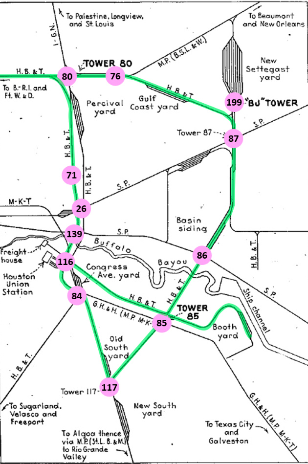 |
Left:
This map appeared in the March, 1952 edition of
Railway Signaling and Communications
in an article discussing recent interlocking changes in Houston. It has
been annotated to illustrate the belt line constructed by
the HB&T around the east side of Houston. Note that the published map
omitted some rail lines, e.g. the tracks of the HE&WT,
which crossed the HB&T at Towers 71 and 76.
Several towers
have been annotated that were omitted on the original map.
The following railroad abbreviations are used on the map:
B. - R. I. (Burlington - Rock Island)
B. S. L. &
W. (Beaumont, Sour Lake & Western)
Ft. W. &
D. (Fort Worth & Denver)
G. H. & H.
(Galveston, Houston & Henderson)
H. B. & T.
(Houston Belt & Terminal)
I - G. N.
(International - Great Northern)
M - K - T
(Missouri - Kansas - Texas)
M. P. (Missouri
Pacific)
S. P. (Southern Pacific)
St. L. B. & M. (St. Louis, Brownsville &
Mexico)
Below:
Tower 189 (Magnolia Jct.) isn't marked on the map at left; it is
located
at the top of the Tower 85 circle, a crossing of two HB&T lines. This
was originally the I-GN Magnolia
Branch, the rails being fully intact in 1952 but since abandoned from
Magnolia Jct. to downtown. As for the
Houston Electric streetcar line that formerly occupied Harrisburg Blvd., Houston's light rail METRORail Green Line now uses the right-of-way. The final step in opening
the Green Line was completion of a bridge over HB&T's East Belt. In the image
below, METRORail's shops and storage tracks can be seen above the light blue "GH&H" label.
(Google Earth image)
 |
Documents in the RCT archives at DeGolyer
Library, Southern Methodist University, include a December 8, 1910
letter from HB&T to RCT submitting the Tower 85 proposal to protect "...the East Belt Line tracks of this company and the tracks of the
GH&H railroad at Baker Street, Houston." RCT engineer R. D. Parker had
serious concerns. He penned a memo four days later questioning whether the plan should be approved. His main issue was that the design
didn't account for the proximity of two additional HB&T crossings -- an
electric interurban and the I&GN's Magnolia Branch -- that were near the
GH&H crossing (see satellite image above.) Parker wrote ... "There is another steam
line that should be taken into the plant I think and an interurban line as
well."
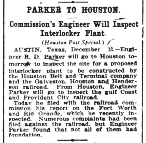
Right:
In response to Parker's concerns, RCT dispatched him to visit the site, as reported in the
Houston Post of December 14, 1910.
[As a side note, Parker was then scheduled to inspect the Gulf Coast and
Provident City Railroad, a line planned for a town being built 26 miles southeast of Hallettsville in
southern Colorado County. Rail historian S. G. Reed reports the railroad's charter was granted on January 11, 1910.
Eleven months later, there would not be much
for Parker to inspect. The railroad never proceeded beyond some grading efforts, and Provident
City peaked at 500 people and then dissolved into ghost town status.]
Parker eventually signed off on the proposal. Notes
suggest that
the inclusion of spare levers for future
use in the interlocking plant was sufficient to overcome his objections.
Tower 85 was commissioned by RCT on May 3, 1911 with a 12-function
mechanical plant. RCT's list of interlockers dated December 31, 1923
reduced the number of functions to 11, and, suspiciously, changed the
commissioning date to May 3, 1919. This error was corrected three years
later; the number of interlocker functions increased to 19 and the date
reverted to 1911. This was merely a swap of the 2-digit year and the
number of interlocker functions, i.e. the original error was just a
typesetting mistake. RCT's list dated December 31, 1927 inexplicably
changed the commissioning date to February 10, 1911. A year later, the
number of functions increased to 21 and the commissioning date reverted
to May 3, 1911. |
 |
An expert on Houston's electric lines, Steve Baron, explains that Parker was
slightly mistaken...
"The electric line on Harrisburg Road was a
streetcar line, not an interurban. The steam road people may have referred to it
as an interurban but it was just a long suburban streetcar line, built and
operated by the Houston Electric Co. which was the local streetcar
operator. This track was used by two routes, the Harrisburg line and the Central
Park (later called Port Houston) line. Service on the Harrisburg line ended in
1928 and on the Port Houston line in 1936, at which point the crossing was most
likely removed. As was the case with virtually all crossings between city
streetcars and steam roads, the crossing was uncontrolled and the railroad
trains had priority."
As the annotated satellite image above shows, Parker's concerns were well-founded. The
diamond at Tower 85 was only about 700 ft. from the streetcar crossing at
Harrisburg Blvd, and the I&GN's Magnolia Branch was approximately 300 ft. beyond. All trains stopped at
the uncontrolled Magnolia Branch diamond; this was the law for uncontrolled
crossings of two railroads at grade and it was also explicitly stated on a 1934
drawing of the Tower 85 interlocking plant. Although Tower 85 benefitted GH&H
trains by allowing them to maintain track speed if the diamond was unoccupied, HB&T trains passing through
Tower 85 were either slowing down (northbound) for the stop at Magnolia
Jct., or attempting to gain speed (southbound) from having stopped there already.
Tower 85 would never maximize operational benefits for HB&T until the Magnolia
Jct. diamond was interlocked. RCT held a hearing on October 30, 1942 to approve
an automatic interlocker for the Magnolia Jct. crossing and the plant was commissioned as Tower 189 shortly thereafter.
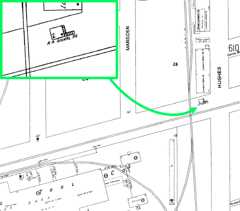 |
Left: The 1925 Sanborn Fire Insurance map of
Houston shows the precise location of Tower 85 in the northeast quadrant
of the diamond west of Hughes St. Magnification (inset at upper left)
identifies it as a two-story "R R Signal Ho" (railroad signal house) with an external staircase on the
east side that incorporated a right angle turn. The landing at the top
level was at the opposite end from the door (black dot.)
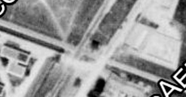
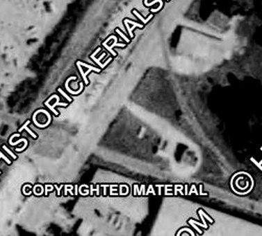
Above: ((c) historicaerials.com)
The dark black square in the middle of this 1930 image is the roof and
shadow of Tower 85. The tower is in the northeast quadrant of the
diamond, roughly equidistant between the HB&T tracks (to the west) and
the Hughes St. roadway (to the east.)
Below: ((c) historicaerials.com) The tower is
not present in this 1947 image, replaced by what appears to be a
trackside equipment cabinet.
 |
RCT initially listed Tower 85's location simply as "Houston", but beginning
with the 1928 RCT Annual Report issued in January of that year, the site was
renamed Houston (Baker St.) Files at DeGolyer Library contain RCT correspondence
dated March 16, 1934 authorizing the Tower 85 interlocker to be remotely
controlled from Tower 86. This presumably led to the demise of the Tower 85
structure and likely explains why no photos of it have been located. However, there is documented evidence (below) that some sort of Tower 85 structure was reestablished
in later years.
 |
Left and Above:
A case published in 1953 from the National Railroad Adjustment Board
involved a union complaint about loss of telegraph operator jobs due to
a terminal consolidation agreement between the I-GN and HB&T. The
agreement specified that "telegraphing that was being performed at Congress
Avenue would be moved to Tower 85." Clearly,
some kind of manned Tower 85 structure
existed when the agreement was made in 1949. The passage states that
Tower 85 was "three miles from Congress Ave. yard office" which is
reasonably close to the actual distance, i.e. presumably this new Tower 85
was at the traditional Tower 85 junction. Was there a reason that
operations personnel needed to be at this specific location? Or...was it merely convenient real estate
owned by HB&T, i.e. a place to put a building (or use an existing
one) that could just as easily have been
located somewhere else? The answer has not been determined.
The
passage above also has a mysterious reference to "Tower
1", apparently some sort of Houston-area control point, not the
Tower 1 located in Bowie, Texas. |
 |
 |
 |
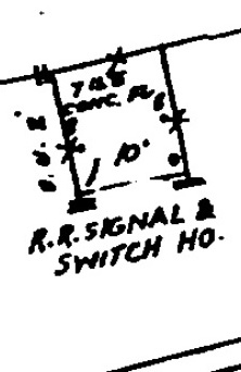
Far Left: The March, 1950 update to the Sanborn Fire Insurance
maps of Houston shows a one-story "Railroad Signal & Switch House"
located in the northeast quadrant of the Tower 85 crossing. This
concrete ("Conc.") structure was east of Hughes St. whereas the original
tower was west of Hughes St.
Middle: ((c) historicaerials.com)
This 1966 aerial photo of the Tower 85 crossing shows a building in the
northeast quadrant consistent with the structure shown on the Sanborn
map. A light gravel parking area surrounds the building and connects to
Hughes St.
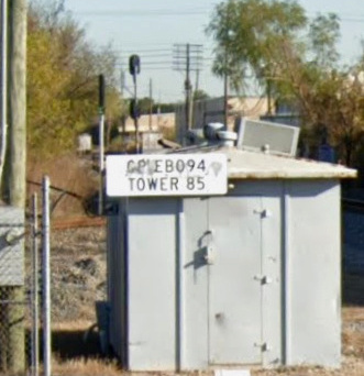
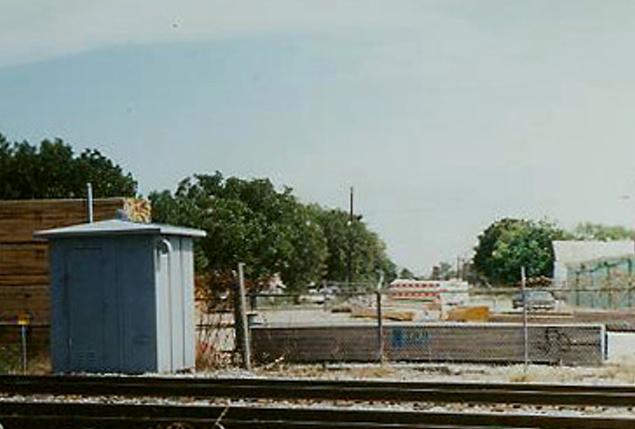
Near Left: A Tower 85 equipment cabinet remains intact
east of Hughes St.
as of December, 2019. (Google Street View.) |
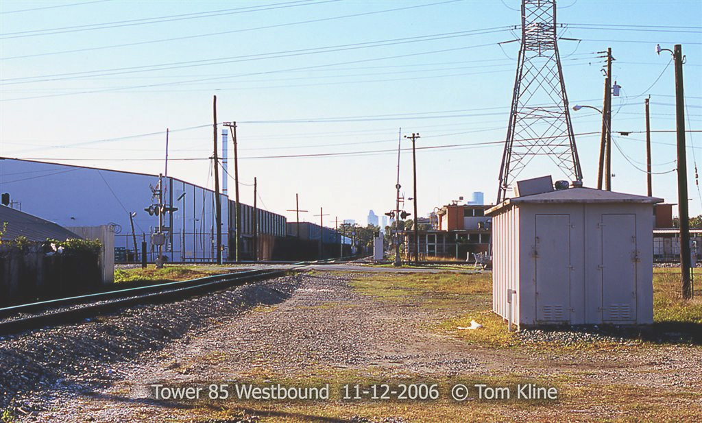
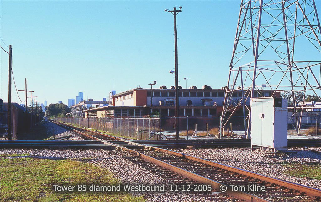
Tower 85 Site Photos by Tom Kline (click to enlarge)


Magnolia Junction
(Tower 189)
In 1890, John T. Brady established the
Magnolia Park community on 1,374 acres he owned
east of Houston along the south bank of Buffalo Bayou. He promptly built a large amusement area
on the waterfront, and to ferry passengers there from downtown Houston, Brady chartered the Houston Belt & Magnolia Park (HB&MP) Railway.
He also planned to develop industries along his waterfront, to be served by his
railroad. The HB&MP lasted only a year before
entering receivership, but it managed to stay afloat during the 1890s by leasing
some of its tracks to other railroads. The HB&MP was sold to Herbert F. Fuller
in November, 1898, and six months later, Fuller transferred the property to the
newly chartered Houston, Oak Lawn & Magnolia Park (HOL&MP) Railway. Shortly
thereafter, the HOL&MP was sold to the I&GN. Plans for the Houston Ship Channel
were in work and the I&GN had the same vision that motivated Brady to charter the
HB∓ ocean-going ships would soon traverse Buffalo Bayou and industries would
populate the waterfront. The City of Houston owned some of this land and
established the Port of Houston, served by the I&GN. When HB&T's East Belt was
constructed, it crossed the I&GN Magnolia Branch a thousand feet north of the
Tower 85 crossing. Aerial imagery from 1930 shows a connecting track had been
added in the northwest quadrant, and the crossing was interlocked in 1942 as Tower
189. At some point after 1950, ownership of the branch was
conveyed to the HB&T.
 |
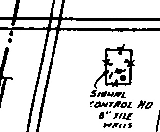
Left:
The 1950 update to the 1925 Sanborn map shows an equipment cabinet
located at Magnolia Junction.
Below: Magnification
reveals a one-story "Signal Control House" with 8-inch tile walls,
presumably an equipment cabin that housed the automatic interlocker. A
door on the south side provided access for maintenance personnel.
 |

Above Left: This view is to the west-northwest
toward Magnolia Junction from 65th St. Whereas the tracks originally continued
straight ahead into downtown, sometime prior to 1984, the Magnolia
Branch
tracks west of the East Belt were abandoned. (Google Street View, 2017)
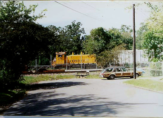
Above Right: Kenneth Anthony
explains this 1991 photo he took looking west on Avenue C, the street where he
lived as a kid:
"In the 1950s into the 1990s, SW diesel switchers were seen on
nearly all HB&T jobs. All were black when I was kid, then black with yellow
tiger safety stripes on the corners, and finally yellow. This HBT switcher is
going south on the East Belt line, with the Magnolia Junction northeast quadrant
curve in the foreground." The northeast quadrant curve
that Kenneth references is the right-hand track in the image above left.
Kenneth Anthony grew up in a house located on the
southwest corner of Avenue C and 65th St., literally a stone's throw from Magnolia
Junction. Below are some of Kenneth's recollections of Magnolia Junction and the
trains that passed through it:
A little about Magnolia Junction in
Houston, where I grew up. In the baby book my mom kept for me, she recorded that
the 9th word I spoke was "choo choo." My childhood bedroom had a window about
100 feet from the former Houston Belt & Magnolia Park Railway, a branch line of
the Houston Belt & Terminal, and 500 feet from the East Belt of the Houston Belt
& Terminal. ... I didn't know it as an infant, but there was a connection on the
northwest quadrant of the crossing of the East Belt and the Magnolia Branch. No
connections existed then on the other quadrants. There were major railroad
changes “in my backyard” when I was three years old, about 1947. The railroad
bought and tore down two houses at the west end of Avenue C, to clear
right-of-way to build a curve to connect the East Belt and the Magnolia line on
the north-EAST quadrant of the crossing. This formed a wye which allowed turning
locomotives or short cuts of cars. It also allowed continuous running between
the north end of East Belt with either west or east on the Magnolia Branch.
Whenever a train went around curve nearest my house, the wheels went
SKREEEEEEEE! ...
An incident
from before I started taking pictures of railroads. It was between 1953
and 1956 because those were the years I walked home afternoons from Burnet
Elementary School on Canal Street. A train derailed at Sherman Street,
right at the turnout where the northeast interchange curve from Magnolia Branch
connects to HB&T East Belt. A boxcar overturned and went through the side
of a house. I saw the aftermath. The house, south side of Sherman
and just east of HB&T East Belt was torn down and the property remains vacant
to this day.
I never saw any passenger trains as such on
the Magnolia Branch or the East Belt of the HB&T, but I
clearly remember one unusual sighting from my back driveway when I was three
years old, just after the new curve was laid on the back side of the block where
I lived. The squeal of a train around the curve got my attention in time to see
a flat car with seats mounted on it for people to ride. There weren’t any
riders, but it was so unusual I remembered it clearly. Never saw it again until
FIFTY YEARS LATER when I found archived copies of a Port of Houston promotional
magazine, and there was a photo of that car. The issue was dated May 1948, the
year I was 3 years old. An article said there had been an inspection train for
officials to view new railroad facilities at the port. The observation flatcar
may have been on a “shakedown cruise” or “dry run” before the bigwigs took their
tour when I saw it crossing 65th Street. The new curve built at Magnolia
Junction may have been one of the new railroad facilities to serve the port. It
was some two miles from the port, but it certainly made the south side of the
port more accessible to traffic on the HB&T.
As for everyday trains: I regularly
saw 2 or 3 short trains a day on the Magnolia Branch. Just about the time of the
curve construction, the locomotives changed from steam (“choo choo”) to diesel.
My dad described the diesels as going “boogedy boogedy boogedy” instead of “choo
choo.” Black switchers with white lettering, what I now know as Roman font,
pulling five or ten cars. And never a caboose on the Belt. As I grew a little
older and began looking farther, I saw quite a bit more traffic going up and
down the East Belt. Usually Belt switchers with a few cars. But sometimes
Missouri Pacific trains with blue F-units and blue GEEPs.
I was not sure
from childhood memory when the southeast curve was laid at Magnolia Junction,
but I found a photo and document which showed it had been done by 1953. The new curve
connected with the east track of the East Belt just short of Harrisburg
Boulevard and allowed direct runs of trains from the south on the East Belt
(such as from New South Yard) to the south side of the Port of Houston. Because
the crossing is not at right angles but at 72 degrees, the northeast curves and
southeast curves are not the same length, though apparently both are of about
the same radius (sharp!) The southeast curve only has to turn 72 degrees and can
do it in less distance from the crossing, than the northeast curve which has to
navigate 108 degrees of curvature, which puts its east end switch frog right in
the east edge of 65th Street. Laying the southeast curve required taking land
from the Contractor’s Supply lumberyard. The older lumber sheds at the west end
of the site, open to a central courtyard, were torn down and replaced with
fully-enclosed cabinetwork and millwork buildings, their walls truncated to fit
within the new railroad curve. The west end of the lumberyard’s industrial spur
was also re-laid to fit on the inside of the junction connection curve. The lumberyard needed more room for outside lumber storage. But
where? The southeast curve left only a sliver of room in a triangle between the
curve, the Magnolia Branch and the East Belt. The geometry of the 72 degree
diamond crossing of the two rail lines created a somewhat larger triangle of
land inside the northeast quadrant, one made unsuitable for residential use by
the heavier rail traffic, and cut off from the adjacent neighborhood by the
raised grade of the track. Some kind of arrangement was made for the lumberyard
to use the area. Fill dirt was trucked in to bring the area up to rail top level
to allow an easy private crossing from the lumberyard across the southeast curve
and the Magnolia line. It would be used by forklifts carrying long loads of 2x4
studs, some 16 and 18 feet long, so a fairly smooth crossing was needed. During
the time before the fill dirt was graded and asphalted over, neighborhood kids
played in this area when no construction workers were present. Explored, built
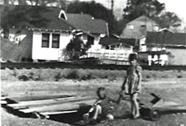
forts, etc. That was the occasion in March
1955 for my shooting a picture of my little brother Shelley, neighbor girl
Beverly and a “fort” built of scrap lumber. (This photo,
below left, was on
the first roll of film I ever photographed, at age 10.) In the background beyond
the track, the 3 houses on the south side of Avenue C were left after the
railroad condemned and demolished two houses for the curve. The nearest house
has a horse stable and chicken coops, laid out to fit in the irregular back of
the property left after a portion was cut off by the railroad. Farther back, the
barn-shaped building is my father’s sheet metal fabrication shop on the ground
floor, with a Lionel train layout on the upper floor.
In this photo from 1991 (below right),
the “Brady” sign referred to the crossover, located in the
block south of Brady Street. Before 1970 or so, the East Belt was mostly single
track, but a siding went off to the east of the single main track between
Sherman and Brady, and the north-east quadrant of the Magnolia connection was
accessed through that siding. The siding rejoined the main track just north of
Tower 85, and the siding also accessed the curve from the East Belt to GH&H.
Another siding diverged from the HB&T East Belt main track on the west side
between Sherman and Brady, paralleling the East Belt northward to provide access
to Esperson industrial district between Canal and Navigation. An HB&T
system map from a 1974 Zone Track Spot book seems to label that siding as
“Burris.” The Burris siding and the siding to Magnolia Branch overlapped each
other. Then when the East Belt was doubled tracked, with a second track
continuing the alignment of the Magnolia access siding, it created a crossover,
to which the Brady name apparently refers.

Eventually, the crossing of the East Belt and Magnolia Branch was completely eliminated.
Crossing pulled up and Magnolia Branch west to downtown abandoned and
pulled up. Now a hike and bike
trail. The photo (above left)
is taken standing right in the middle of where the Magnolia Branch tracks USED
to be, and looking straight west down the alignment of the former track.
This photo (above
right) was taken in August 1990
from just south of the dead-end of Avenue C. looking west and it shows what
the northeast quadrant connecting curve looked like for most of the period from
1955 to 2005. Contractor's Supply and Lumber Co. had outside lumber storage in the
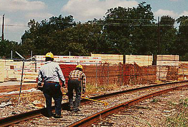
open area inside the wye. In the photo, some kind of track alignment check
is being made.
I do not
remember ever seeing any traditional manned 2-story tower at Tower 85, but it
would have been on the east side of Hughes Street. I almost always walked right
along the railroad and saw the tracks and the crossing, and a guardhouse for
entering Hughes Tool. It could have been there and I just missed it. I also
missed ever seeing the MoPac Galveston section of the Texas Eagle passenger
train, even though it was running barely 4 blocks from my home. One thing I DID
see, late 1950s or early 60s… crashed diesel locomotives
from what looked like two trains that got to the crossing at the same time, one
eastbound on GH&H and one southbound on HB&T East Belt. One diesel turned
over on its side, and one standing ON END. At least, that’s my memory as
an early teen...
Thanks for the memories, Kenneth!