Texas Railroad History - Towers 86
and 214 - Houston (Magers and Galena Junction)
Crossings of the Southern Pacific Railroad with
the Houston Belt & Terminal Railway and the Port Terminal Railroad Association in East Houston

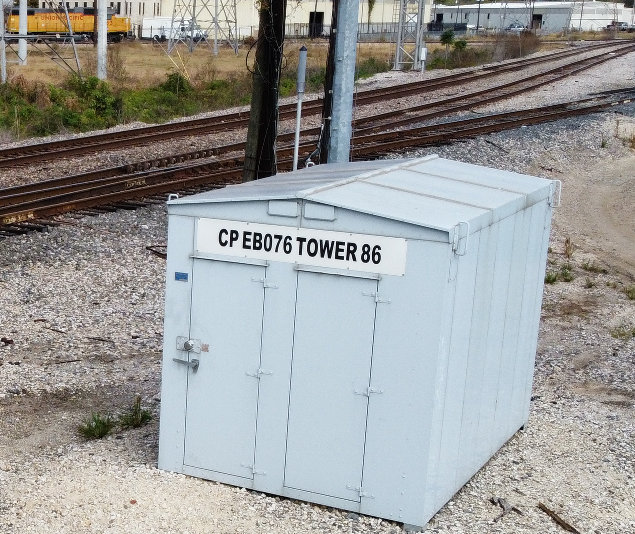
Above Left: Until a
photo of the original Tower 86 manned structure can be located, photos of the
Tower 86 equipment cabinets will have to suffice. Just like manned towers,
equipment cabinets changed designs over time. (Jim King, December 2006)
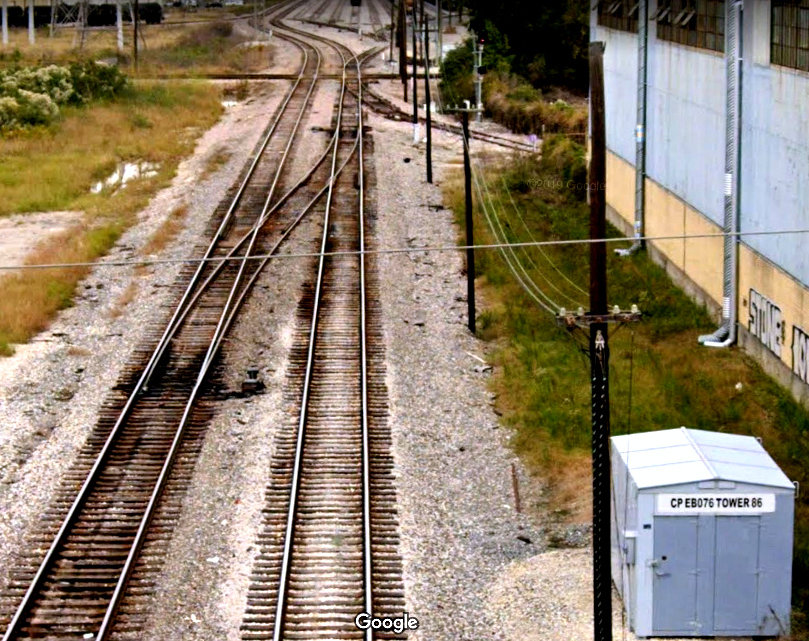
Above Right: This cabinet sits
in the northeast corner of the Tower 86 diamond (off the image to
the far left.) The UP locomotive in the distance is on a spur track out of Basin
Yard. (Abel Garcia, November, 2020)
Tower 86 is located in east Houston at a crossing of the Houston Belt &
Terminal (HB&T) Railway and the Union Pacific (UP) Railroad, a line UP
inherited during its merger with Southern Pacific (SP) in 1996. The SP tracks
were originally built by the Texas
Transportation Co. (TTC) in 1876. The TTC had been founded ten years earlier by
John T. Brady as part of a plan to develop
his property along the south bank of Buffalo Bayou. Slow economic recovery
after the Civil War resulted in the TTC accomplishing very little. By 1876,
controlling interest in the TTC had been obtained by Charles Morgan, the owner
of a large steamship business that dominated shipping in the Gulf of Mexico.
Morgan wanted the TTC for its state charter because it could be modified easily
and he was in a hurry. Instead of the south bank, the TTC line would run along
the north bank of Buffalo Bayou from near downtown Houston to Morgan's newly
established port of Clinton, a distance of eight miles. Morgan needed rail
service as quickly as possible so that shippers would be enticed to use the port
he was establishing at Clinton,
from which he had already dredged a channel to the Gulf deep enough for his
ocean-going steamships. (The first use of the Clinton port was to bring in
materials for the rail line's construction.) Shortly after the TTC line was
completed, Morgan established a holding company for his various steamship and
railroad properties including the TTC. Morgan died in 1878 and his holding
company was subsequently acquired by SP, which later assigned the TTC rail
line to one of its Houston-area subsidiaries, the Galveston, Harrisburg & San
Antonio (GH&SA) Railway.
The other tracks at Tower 86 belonged
to the Houston Belt & Terminal (HB&T) Railway. The HB&T had been founded in 1905 as
a switching and terminal railroad by four companies: the Gulf, Colorado & Santa
Fe (GC&SF) Railway and three railroads controlled by native Texan B. F. Yoakum: the St. Louis, Brownsville & Mexico
(SLB&M), the Beaumont, Sour Lake & Western (BSL&W), and the
Trinity & Brazos Valley (T&BV). In addition to constructing a Union
Station to support passenger service, HB&T's charter included building a belt line around the city to facilitate freight exchange among
multiple yards. Records of the Railroad Commission of Texas (RCT)
attribute construction activities to the HB&T in 1907 and 1912, but it is
likely that there was additional construction in the intervening years. The
result was a semi-circular belt line around the
east side of Houston along with new tracks north and south out of downtown. The
track segments in east Houston became known as the East Belt.
The southern endpoint of the East Belt
was on Santa Fe's branch line into Houston, just north of a new freight yard,
New South Yard, built by HB&T. Santa Fe's branch
line was also used by the SLB&M to reach Houston from Algoa
via Tower 81 at the south end of New South Yard.
More than a century after its founding, HB&T continues to operate, now owned
jointly by UP and Burlington Northern Santa Fe (BNSF).
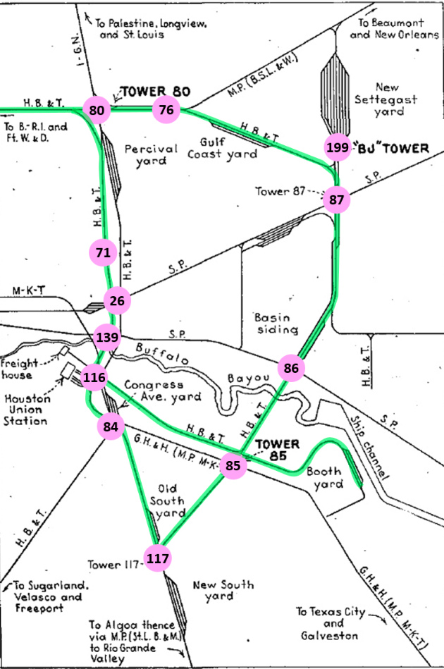 |
Left:
This map appeared in a Railway Signaling and Communications
(March, 1952) article about recent interlocking changes in Houston. It's
been annotated to illustrate HB&T's semi-circular belt line around the east side of Houston.
The published map
omitted many rail lines and towers that would otherwise be
visible, e.g. the tracks of the Houston East & West Texas Railroad,
which crossed the HB&T at Tower 76, were not shown. Towers 76 and 86
have been annotated but were not marked on the original map; several other lines and towers that were active in 1952 were also omitted.
Note the track location immediately north
of Tower 86 was known as "Basin Siding", but it has since been expanded
significantly to become Basin Yard.
The following railroad abbreviations are used on the map:
B. - R. I. (Burlington - Rock Island)
B. S. L. &
W. (Beaumont, Sour Lake & Western)
Ft. W. &
D. (Fort Worth & Denver)
G. H. & H.
(Galveston, Houston & Henderson)
H. B. & T.
(Houston Belt & Terminal)
I - G. N.
(International - Great Northern)
M - K - T
(Missouri - Kansas - Texas)
M. P. (Missouri
Pacific)
S. P. (Southern Pacific)
St. L. B. & M. (St. Louis, Brownsville
& Mexico)
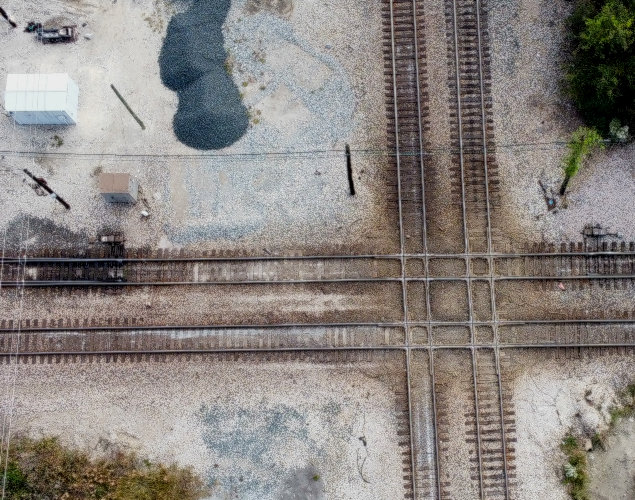
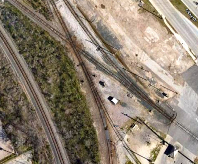
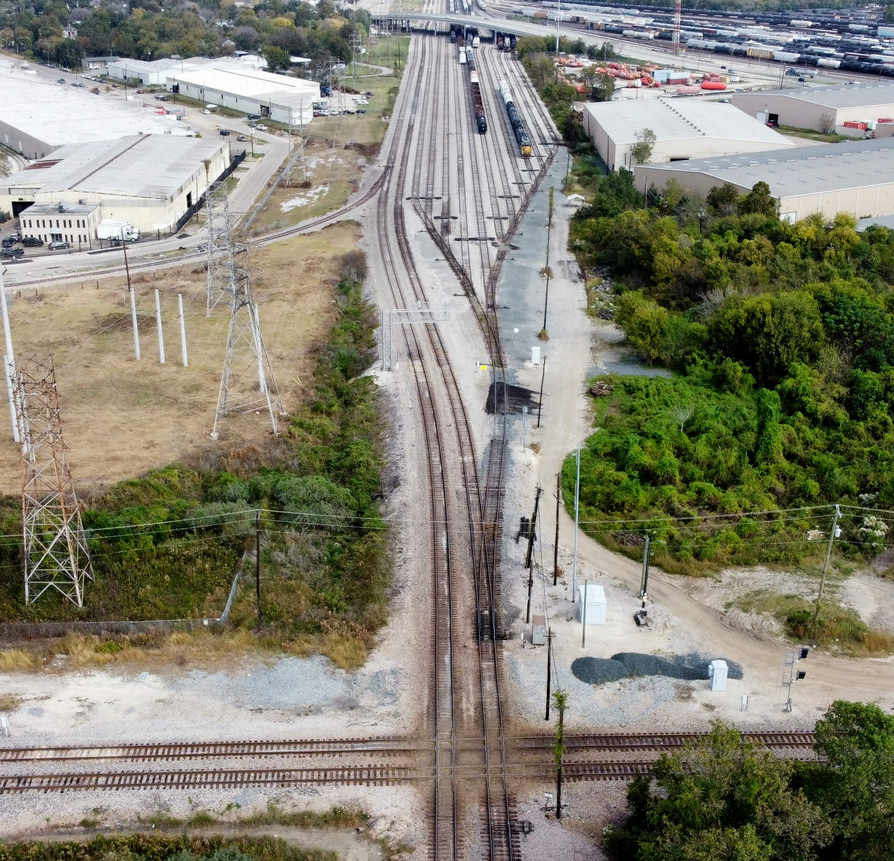
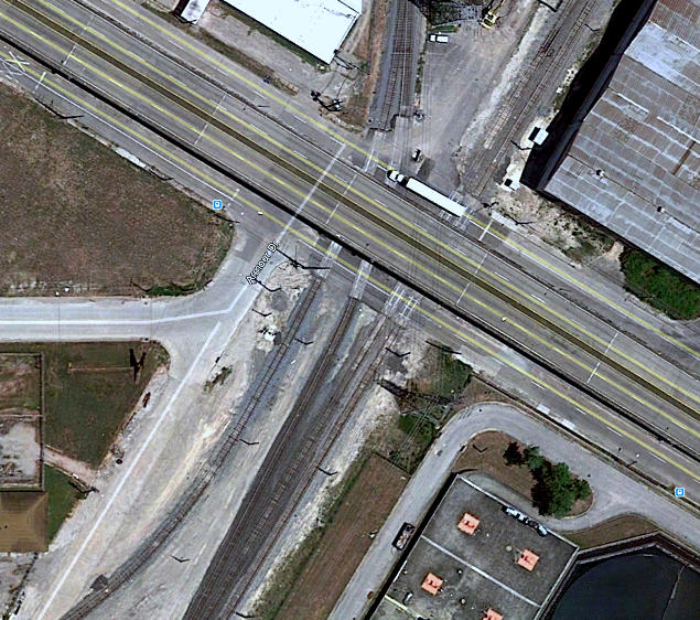
Below:
drone view of the quad-diamond at Tower 86; east is up and the white
cabinet at upper left is the same one as in the photo at the top right
of this page (Abel Garcia, Nov. 2020)
 |
Tower 86 first appeared in RCT's annual published list of active
interlockers dated October 31, 1911, reported
to be a 12-function mechanical plant. It was commissioned on April 19, 1911, the same day
as
Tower 87 (at the east end of Englewood Yard), the next tower north of Tower
86. The Tower 86 entry in RCT's list
remained static over the years until December 31, 1927 when the GH&SA was no longer mentioned as one of the railroads at Tower 86,
having been replaced by the Texas & New Orleans (T&NO) which had officially leased the GH&SA (and would fully
merge it in 1934.) The T&NO was to become SP's primary operating subsidiary in
Texas and Louisiana. The December 31, 1927 list was also the first occasion that RCT identified Tower 86
as being located at "Houston (Magers)"; all previous lists just said "Houston".
The term "Magers" is presumably a community or landowner reference. The Handbook
of Texas does not have an entry for "Magers" and no other independent references
(i.e., outside of the railroad context of Tower 86) have been found thus far.
Magers is referenced in two entries in RCT's database of railroad construction
and abandonment. In 1900, the Galveston, Houston & Northern built 1.21 miles
with endpoints identified as "Between Brady" and "Magers". While Magers was presumably at or near the Tower
86 crossing, Brady was an imprecisely defined location south of Buffalo Bayou,
as explained for Tower 102. The other RCT
construction entry for Magers is
a 1901 abandonment by the same railroad with the same endpoints, but with 2.06
miles of track removed. The origin of the term "Magers" remains a mystery.
A photo of the original Tower 86 has
not been located. With HB&T constructing several towers in the 1910-1912
timeframe, it's reasonable to assume that it shared much commonality with the
original versions of HB&T's Towers 80,
84, 87 and
116, for which photos
have been identified. Tower 86 was approximately two miles north of Tower 85
which took over remote control of the Tower 86 interlocker in
1960. Control of the interlockers for both of these towers was later consolidated
into Tower 199 at Settegast Yard.
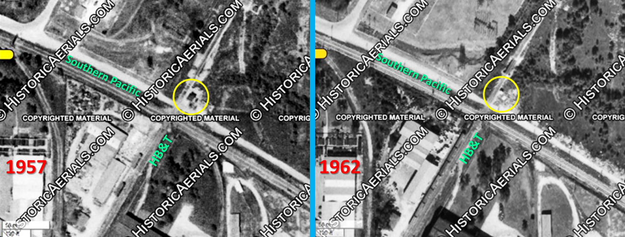
Above: It is apparent from
these annotated side-by-side aerials ((c)historicaerials.com) that the manned
tower structure (yellow circle) that sat in the northeast quadrant of the
"X-pattern" diamond at Tower 86 was removed between 1957(left) and 1962 (right),
replaced by a white or silver equipment cabinet. In the 1957 aerial, it is
apparent that the tower sat immediately north of Old Clinton Road, whereas SP's tracks were "across the
street" south of Old Clinton Road.
Below
Left: Looking northeast from the Clinton Drive overpass, the
tracks of Basin Yard are visible in the distance. The horizontal tracks ahead are at the
Tower 86 crossing where the original line to Clinton (now UP's Strang
Subdivision) crosses the HB&T East Belt. The Tower
86 cabin visible trackside along the HB&T is labeled the same
as the one in the photo at top right of this page, but it's not the same cabin
(or at least, not in the same location.) This one is well south of the diamond;
the other, a more recent photo, is in the northeast quadrant of the diamond. (Google Street View, 2019)
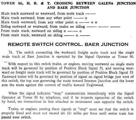
Below Right: The T&NO Time
Table for the Beaumont and Terminals Divisions dated September 7, 1930 includes
whistle codes for signaling the Tower 86 operator along with remote switch information
for traversing Baer Junction, which the Tower 86 operator also controlled. Baer
Junction, about 0.9 miles west of the Tower 86 diamond, was where SP built a
short branch off the Clinton line that ran north to Englewood Yard. This branch
was built in 1896, about a year after SP had built Englewood Yard, to provide SP
with a way to move trains between the industries along Buffalo Bayou and
Englewood Yard without having to transit via downtown Houston.
The Tower 86 crossing is within a half mile of Buffalo
Bayou, which has been an important transportation artery for commerce since 1836
(particularly in the early days for shipping cotton.) On November 10, 1914 the
eastern part of Buffalo Bayou officially opened as the Houston Ship Channel, and
by 1919, it had been dredged sufficiently to support ocean-going ships directly
from the Gulf of Mexico.
Initially, SP, HB&T and the International & Great Northern (I&GN) were the only
railroads with direct access to businesses along the Ship Channel, but many of
its industrial sites had yet to see development. In 1924, the Port Terminal
Railroad Association (PTRA) was formed to provide switching and port access
services for all of the railroads serving Houston. Although PTRA's official
history claims eighteen railroads were involved in its founding, in reality,
many of these were (or soon would be) subsidiaries of common parent railroads,
e.g. six of the eighteen were owned by SP, and a seventh, the San Antonio &
Aransas Pass, would be acquired by SP in 1925. As another example, on January 1, 1925,
the I&GN, along with four other PTRA railroads plus half-ownership shares in two
additional PTRA railroads (the HB&T and the Galveston, Houston & Henderson) came
under the ownership of Missouri Pacific. Today, UP, BNSF and Kansas City
Southern are the railroads that participate in the PTRA.
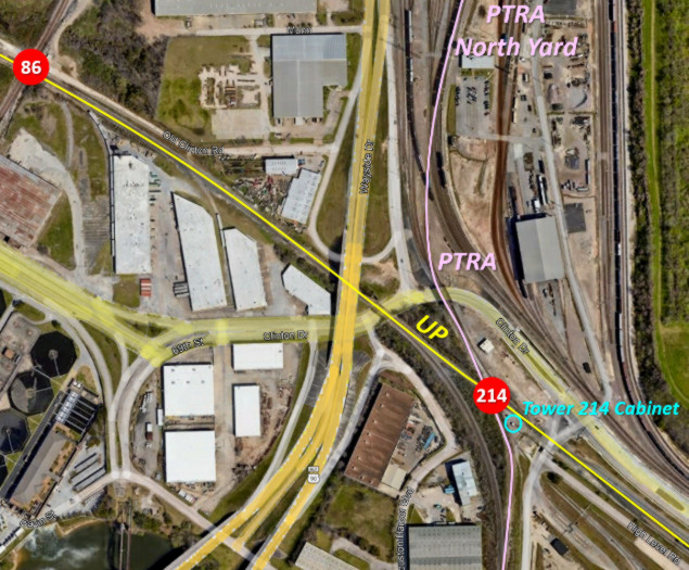
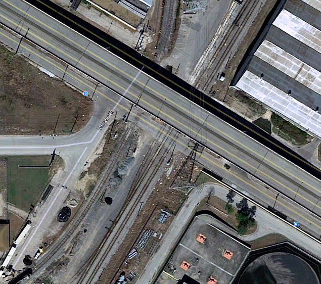
Above Left: Tower 214 is an automatic interlocker that
was installed in 1966, the second to last
interlocker ever numbered by RCT. It is located at Galena Junction, where the former TTC
(GH&SA) line
to Clinton crosses PTRA tracks less than a half mile
southeast of Tower 86. North of Tower 214, the PTRA tracks lead to PTRA's North
Yard. To the south, the tracks proceed across Buffalo Bayou adjacent to the
Turning Basin of the Houston Ship Channel and continue to
Tower 208 and beyond. (Google Earth, January 2022) Above Right: This
closer view of Galena Junction shows the white interlocker
cabinet in the acute-angled southeast quadrant of the crossing. Galena Junction
is near the street intersection of Clinton Drive and Port of Houston Gate 8. Access to
the Port facility is restricted; the guard gate for Gate 8 is the small building in
the lower right corner of the image. (Google Earth, January 2022)
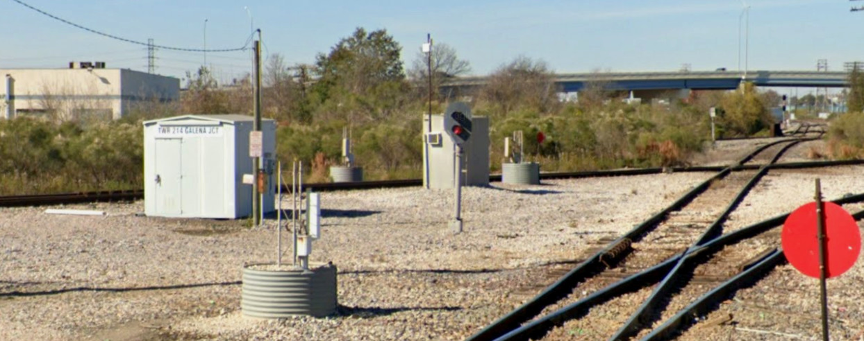
Below: In this Google Street View from December, 2019, the
interlocker cabinet is still labeled "TWR 214 GALENA JCT". The view is northwest
along UP's tracks toward Tower 86.
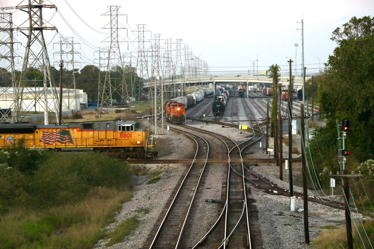
Above: Eastbound UP #8801
waits to cross the East Belt at Tower 86 on November 7, 2020. (Christof Spieler
photo) Below: Abel Garcia took
this drone image of Basin Yard and the Tower 86 crossing (at bottom of image) in
November, 2020. The view is north along the East Belt. The PTRA North Yard is
visible to the right.
Despite a century of rail operations at the Tower
86 crossing, there was never a connection between the two lines. There has been
an industry spur in the southwest quadrant for decades, but it did not provide a
connection for the main lines. The need for a connection in this quadrant was
identified as a potential improvement to traffic flow in a Houston Region
Freight Study conducted in 2007. The study described the issue succinctly:
Strang
Subdivision - East Belt Subdivision connection at the SW Quadrant (Tower 86)
Currently, the industrial lead track on the Strang
Subdivision near Tower 86 does not permit northbound trains on the East Belt
Subdivision to connect to the Strang Subdivision. Traffic destined for Englewood
Yard must operate to Tower 87, which is currently constrained during peak
periods of train traffic. Adding the connecting track in the SW Quadrant at
Tower 86 will provide an alternative route to Englewood Yard via the Strang
Subdivision, allowing flexibility in the routing of train traffic which may
potentially alleviate congestion not only at Tower 87, but perhaps Tower 26 as
well.
The "alternative route to Englewood Yard" would involve
northbound East Belt trains transitioning to westbound on the Strang Subdivision
and then immediately taking the Baer Junction track north to Englewood Yard.
Below:
In response to the 2007 freight study, a connecting track was added on the west
side of the Tower 86 diamond as a modification to an existing industry spur. The
connection is not visible in this Google Earth image from February 2014 (left),
but is clearly in place by July 2015 (right).

Above: annotated Google Map of the historic interlockers
in northeast Houston

Last Revised: 12/25/2022 JGK - Contact the Texas
Interlocking Towers Page.