A Crossing of the Galveston, Harrisburg & San Antonio Railway and the Galveston Terminal Railway
|
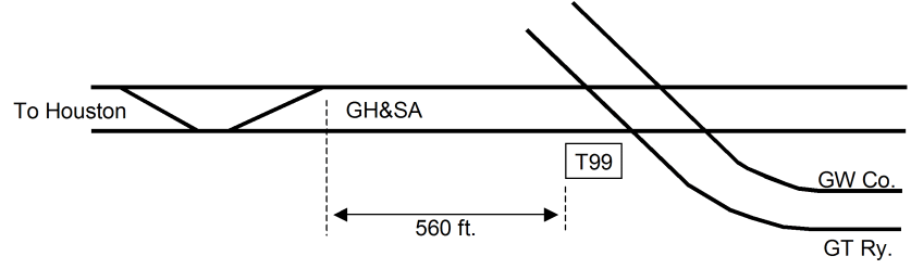
Left: This sketch shows the track arrangement near Tower 99 as depicted by a drawing found in the interlocker archives of the Railroad Commission of Texas (RCT) maintained at DeGolyer Library, Southern Methodist University. The tower was located where parallel tracks of the Galveston Terminal (GT) Railway and Galveston Wharf (GW) Co. crossed a Galveston, Harrisburg & San Antonio (GH&SA) Railway double-track approximately 560 feet east of a GH&SA crossover. There were no other clues on the drawing to indicate a precise location on Galveston Island, but "57th Street" is included in the drawing's title. There is external evidence suggesting that the tower was manned. (sketch by Jim King) |
The precise function and location of Tower 99 on Galveston Island has been difficult to determine, mostly due to its brief existence. It is documented in Railroad Commission of Texas (RCT) annual reports where it initially appears in a List of Interlocking Devices dated October 31, 1914. The List records it as a 40-function electrical interlocker in Galveston located at a crossing of the Galveston, Harrisburg & San Antonio (GH&SA) Railway and the Galveston Terminal (GT) Railway. The tower was commissioned for operation on April 29, 1914, but according to documents at DeGolyer Library, it was "approved for operations in advance of inspection" on April 22, 1914. In 1915, the Tower 99 listing changes only slightly, showing 27 functions instead of 40. In the 1916 report, Tower 99 is removed from the active list and included in a separate list of interlockers "abandoned on account of removal of crossing".
 |
What could account for such a brief existence? The most plausible
explanation is that it was caused by the receivership of the Trinity & Brazos Valley (T&BV) Railway,
the GT's parent company. The T&BV had been founded in 1902 to build
from Hillsboro to Beaumont,
but
it was acquired in 1905 by the Colorado & Southern (C&S) to be a
component of a grand plan formulated by a C&S Board member, Benjamin
Franklin Yoakum. Yoakum was a native Texan, the Chairman of the St.
Louis & San Francisco ("Frisco") Railway but also the CEO of the
Chicago, Rock Island & Pacific Railway. His plan was to compete aggressively
along the Gulf Coast with Southern Pacific
(SP), the parent company of the GH&SA. Yoakum expanded the
T&BV to connect his north Texas Frisco and Rock Island tracks
with a network of Gulf Coast lines he was assembling between New Orleans
and Brownsville. For the C&S, the T&BV would
extend their existing Denver - Fort
Worth route to Galveston. Yoakum took over
the T&BV and negotiated trackage
rights on the Gulf, Colorado & Santa Fe (GC&SF) Railway between Fort Worth and
Cleburne, and between
Houston and
Galveston. Tracks between Cleburne and Houston
and between Teague and Waxahachie
were mostly new construction, adding to existing T&BV tracks between Hillsboro and
Mexia. Trackage rights at Waxahachie on the
Missouri, Kansas & Texas Railway gave Yoakum a complete route between
Houston and Dallas. In August, 1905, Yoakum
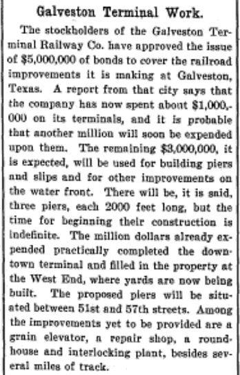
chartered the GT to be his terminal facilities for the Port of Galveston. Left: The April 2, 1908 edition of Manufacturer's Record provided this news item regarding the development of Galveston Terminal Railway facilities that included "...a repair shop, a roundhouse and interlocking plant..." This plan likely produced the interlocking that became Tower 99 six years later. However, the article references "piers and slips...on the water front" and states that the "...proposed piers will be situated between 51st and 57th streets." Early maps of Galveston do not show waterfront property in use for terminal facilities between 51st and 57th streets, and it is apparent from later maps that the GT's waterfront piers and slips were much farther east, closer to downtown. Railroad historian S. G. Reed describes the GT property in his book A History of the Texas Railroads (1941, St. Clair Publishing)... The property consisted of fourteen blocks of water front property. A depot was built and about fifteen miles of tracks. ... [A]n arrangement was made to use the G. H. & S. A. from Houston to Galveston and the terminals were used by the T. & B. V. until 1914, when the road went into receivership and the trackage contract was canceled by a Federal Judge. The property was not used again until 1931 ... [by] the Burlington - Rock Island..." The Burlington - Rock Island (B-RI) was the railroad created by the termination of the T&BV receivership, jointly owned and operated by two railroads that had inherited partial ownership of the T&BV: the Chicago, Burlington & Quincy and the Chicago, Rock Island & Pacific. |
So...why would the bankruptcy of the T&BV cause Tower 99 to be closed? In its article about the Galveston Terminal Railway, the Handbook of Texas provides a clue...
The Galveston Terminal was initially owned by the Trinity and Brazos Valley Railway Company, which supplied the equipment required. However, as a result of its 1914 receivership the Trinity and Brazos Valley discontinued use of the terminal on July 31, 1914. Between August 1, 1914, and January 31, 1919, the Galveston Terminal was leased by the Galveston, Harrisburg and San Antonio Railway Company to supplement its own terminal facilities. The Galveston Terminal then remained idle until June 1, 1931, when the Burlington-Rock Island Railroad Company, successor to the Trinity and Brazos Valley, resumed service to Galveston.
Significantly, the presumed location of the GT's waterfront facilities (much closer to downtown than 51st - 57th streets) happened to be directly adjacent to the GH&SA's waterfront property incorporating numerous tracks serving docks and piers. Thus, it made sense that the GH&SA might wish to lease the GT's facilities since their location could be seamlessly incorporated into the GH&SA's operations.
|
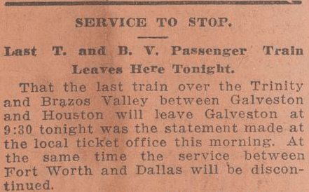
Right: (Galveston
Tribune, July 25, 1914) The GH&SA's lease of the GT
commenced August 1, 1914, only a week after the last T&BV passenger
train departed Galveston. The GT's lease to the GH&SA explains the decision to close Tower 99. At the time, the belief among Texas railroads was that RCT's jurisdiction was limited by state law to crossings of two different railroads. Specifically, the law gave RCT authority "...to define the mode of crossing to be made when one railroad seeks to cross the tracks of another railroad company" (emphasis added.) While the sketch (top of page) shows nearby GW tracks that presumably were owned by another railroad company, those tracks are not referenced by RCT's documentation for the Tower 99 interlocker and there is no explanation of their omission. Tower 99 was listed by RCT solely as a GT / GH&SA crossing, and thus, the lease of the GT to the GH&SA effectively created a crossing of tracks belonging to the same railroad. If RCT lacked jurisdiction to require a railroad to install an interlocker at a crossing of its own tracks, then RCT presumably lacked the authority to force a railroad to continue operating an interlocker at a crossing where both tracks had come under common ownership or control. |
 |
RCT rejected the idea that its authority was limited to
crossings involving two or more railroads. In 1914, it
was in the midst of a long-term dispute with the Houston Belt & Terminal (HB&T)
Railway regarding a similar issue at Houston Union Station pertaining to the interlocker
that ultimately became identified as Tower 116.
HB&T's position was that since it owned all of the tracks at Houston Union
Station, there was no need for RCT to approve the interlocking system it had
developed to control access to the station. None of the crossings
involved tracks owned by another railroad company. RCT disagreed but the
dispute was not resolved until the 1920s (after which,
all interlockings needed RCT approval -- see
Tower 121 and Tower 135.) But certainly at the time of
Tower 99's demise, the idea that the GH&SA could decommission an interlocker for
which it was the only railroad company was not viewed as controversial by the
railroads.
Where exactly was Tower 99? The Tower 99 file at
DeGolyer Library is sparse, but it does include a track chart drawing with the title Galveston Terminal Railway,
Galveston Wharf Co. Crossing with the Galveston, Harrisburg & San Antonio
Railway, 57th Street, Galveston. A letter dated April
12, 1912 from the GH&SA to RCT requesting inspection of the interlocker
refers to Tower 99 being
near 57th St. in Galveston, matching the title block on the drawing.
The drawing shows limited track information (reproduced by the sketch above) and
it does not depict any streets or other geolocation marks that would help to
identify the site. Limited only by the description
near 57th Street remaining applicable, the tower could have been anywhere.
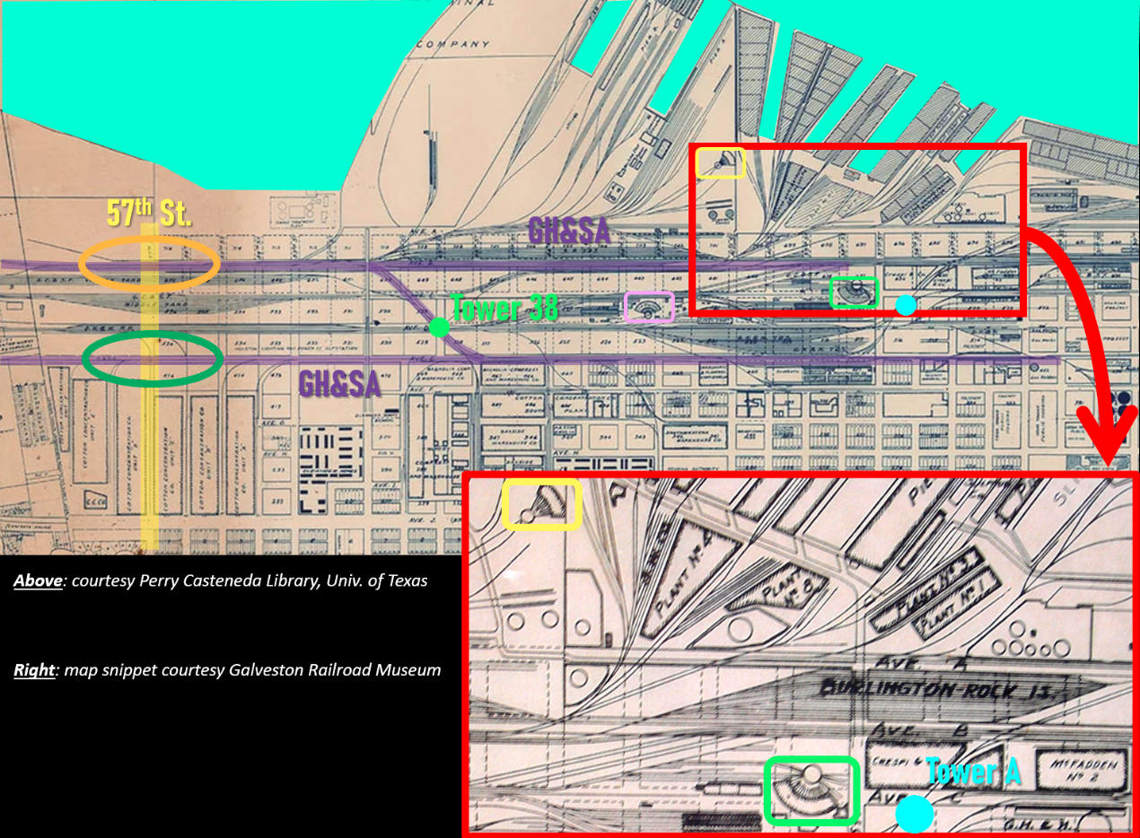
Above: This graphic of annotated maps of Galveston is
oriented with north-northwest "up". Tower 96,
the Island Tower for the Galveston Island Causeway to the mainland, is off the
map to the
left (west.) Downtown Galveston is to the right (east). The GH&SA crossed
57th St. in two places (orange and green ovals.) The map shows Tower 38 at the
GH&SA "Z-Track"
crossing of the Galveston, Houston & Henderson (GH&H), and also shows Tower A
near the Santa Fe roundhouse (green rectangle.) The GH&SA roundhouse (yellow
rectangle) and the GH&H roundhouse (pink rectangle) are also highlighted. Of
significance, the inset map shows the Burlington - Rock Island (B-RI) yards
north of Tower A. This is the former GT yard that was restarted by the B-RI when
it was created to facilitate the emergence of the T&BV from bankruptcy. The
yard is more than a mile and a half from 57th Street, but is directly adjacent
to yards of the GH&SA to which it was leased for several years.
In the above graphic, 57th Street (yellow highlight) was platted on Galveston's master plan, but much of it did not exist as an actual roadway except farther south off the map. There were two GH&SA lines (purple highlight) coming from the causeway toward downtown. The northern line was the former Galveston, Houston & Northern (GH&N) which had originally crossed from the mainland on its own bridge. That bridge was destroyed by the Great Hurricane of 1900. In 1905, the GH&N was acquired and merged into the GH&SA. The south GH&SA line departs from the junction at Tower 96 where all of the steam railroad tracks merged onto the double-track causeway. If the Tower 99 crossing was near 57th Street, it is not apparent on this map, perhaps because the tracks had been reconfigured to eliminate the crossing before the map was drawn.
![]()
Above: Both of these items are
taken from a GH&SA Employee Timetable (ETT) dated May 31, 1914, approximately one
month after Tower 99 was commissioned by RCT. Based on the references to 57th
Street in the Tower 99 file at DeGolyer Library, it is reasonable to assume that
"57th Street Tower" and "Tower 99" refer to the same
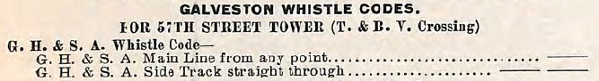
interlocking. The provision (above left) of
GH&SA whistle
codes "For 57th Street Tower (T. & B. V. Crossing)" implies two
important facts: 1) the tower was manned -- someone had to hear the whistles to
take action; and 2) the tower was located at a GH&SA / T&BV crossing near
57th Street that included at least one GH&SA side track. The ETT also notes (above right) that signals
for the T&BV crossing were located 0.47 miles "East of the 'Z'
Yard Office". The "East" reference appears to be an editing mistake. 57th St.
crosses the GH&SA tracks about a half-mile west
of the Z Yard Office and the text is describing "signals
at T. & B. V. Ry. Co. Crossing", i.e. a home
signal, for which a location precisely 0.47 miles west of the Z Yard Office
would fit perfectly. Having a Tower 99 signal a half-mile
east of the yard
office would make little sense because that would place it nearly a mile from a
57th Street crossing, with Tower 38 located trackside in between.
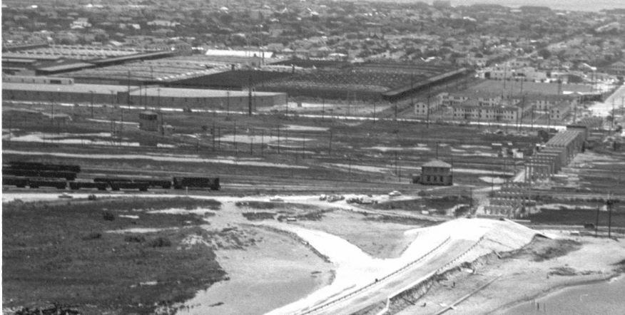 |
Left: This
snippet from a 1956 aerial photo faces southeast showing the 51st St.
overpass under construction on a south-southeast heading. The main lines
horizontally across the image are generally west-southwest
(right, toward the island landing of the causeway) and east-northeast
(left, toward downtown.) Tower 38 is in the left center of the image with the GH&SA Z track crossing in front of it parallel to the long side of the tower. The Z track continues across tracks of the GH&H toward the Z Yard Office (two-story office building near the overpass) where it connects with the SP main line. The GH&SA's 57th Street crossing is about a half-mile west of the office, off the map to the right. (image courtesy Don Harper and the Galveston Railroad Museum) |
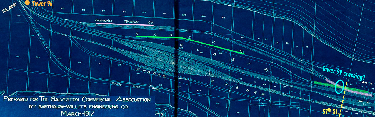
Above: This 1917 map
(courtesy Rosenberg Library) shows Galveston Island between the Causeway and
57th Street. Significantly, it shows an apparent junction (light blue oval)
where the GT (pink lines) and the GH&SA (green lines) crossed near 57th St.
Except for the GW track which is unidentified, this
matches the sketch of the track arrangement at Tower 99 derived from the track
chart drawing at
DeGolyer Library.
Above: This image is taken
from an inset map of Galveston that appears on a larger GHE route map. The map
is undated but at far left, it references both the GT and the T&BV, suggesting
that it dates from the 1912 - 1914 timeframe when the GHE and T&BV were both
operational on Galveston Island.
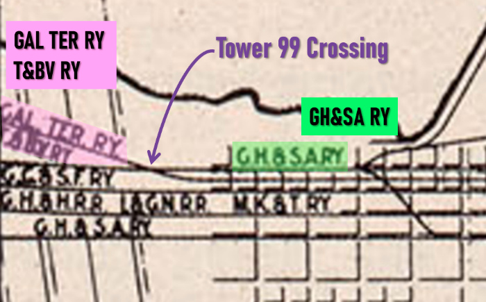
Left: This
magnification of the lower left corner of the above map has been
annotated to provide clarity to the railroad labels. It clearly shows a
crossing of the GH&SA and rails belonging to the GT / T&BV. This
is very likely the location of the Tower 99 crossing.
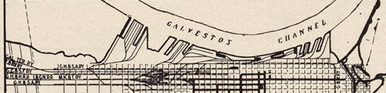
Sanborn Fire Insurance maps of Galveston show tracks in the vicinity of 57th Street, but they lack detail and show nothing that matches the interlocker track chart at DeGolyer Library. It is also possible that soon after the GH&SA lease took effect, the crossing was eliminated and the GT tracks were routed directly onto GH&SA's eastbound tracks. This could account for RCT's description that Tower 99 was "abandoned on account of removal of crossing". This does not account for the possible continued operation of GW tracks at the crossing, but for unknown reasons, the GW was never included as a participating railroad at Tower 99 in RCT's List of Interlocking Devices. To date, no other maps -- neither historic USGS topographic maps nor historic aerial images -- have been found that shed further light on the precise location of Tower 99.