Texas Railroad History - Towers 71, 76 and 210 - Houston
Three Interlockers on the Houston East
& West Texas Railway
in North Houston

Above: By the time John W.
Barriger III snapped this photo of the Tower 71 crossing as he looked south from
his business car in the early to mid 1940s, the single-story building that
served as the tower was long gone. The interlocker remained in place, however,
operated remotely from Tower 26 which Barriger's train had just passed a couple
of minutes before. Years earlier, Tower 71 would have been directly in the forefront of Barriger's
view, on the west (right) side of the tracks near the crossing amidst numerous utility poles in this industrial area of north Houston. Barriger's
International & Great Northern train,
northbound on the HB&T toward Tower 80, has
just crossed T&NO's former HE&WT tracks that ran north out of downtown.
In a few moments, Barriger will see the T&NO tracks swing away from him to the left on a northeast heading toward Tower 76 and east Texas
beyond. The cars visible in the image are on Quitman Street which crossed both rail lines at
grade. (John W Barriger III National Railroad Library)
Below Left: The 1924 Sanborn Fire Insurance map of
Houston depicts Tower 71 as a small rectangle near the HB&T/HE&WT crossing north
of Quitman Street (adjacent to "47" near the center of the image.) Magnification
reveals "Signal Tower" written next to the rectangle.
Markings inside the rectangle indicate a single story building with
a south side door facing the diamond.
Below Right: Long ago, Tower
71 became merely an equipment cabinet; a photo of the
original manned tower has not been found. The interlocker was controlled
remotely starting in 1930,
hence the building was
in use for less than 25 years. By the time this photo was taken in 2006, the
Tower 71 crossing diamond had been retired for ten years, but the "71" equipment
cabinet survived. (Jim King
photo)


The Houston East & West Texas (HE&WT) Railway was
called "the Rabbit", but the origin of this nickname is in dispute. One source
claims it derived from passengers shooting rabbits from the train during stops
en route between Houston and Shreveport. A more
plausible explanation can be found in Robert S. Maxwell's book Whistle in the
Piney Woods [East Texas Historical Association and University of North Texas
Press, 1998] where he writes... Because of its short, bobbing,
narrow-gauge cars, its up and down hill roadbed, its tendency to jump the track,
and, above all, its proclivity for "stopping behind every stump", the road was
promptly labeled "The Rabbit". Whatever the case, "the Rabbit" was a narrow gauge track from Houston to
Shreveport, although technically, HE&WT's ownership interest ended at the
Louisiana border. Construction commenced in Houston in 1877 and proceeded slowly
northeast. It took nearly a decade to reach the Sabine River boundary between the two
states, 40 miles southwest of Shreveport. The bridge over the Sabine into
the town of Logansport, Louisiana opened on January 26, 1886.
Hard
economic times led to bankruptcy for the HE&WT, a common occurrence for
railroads of this era. After receivership and reorganization, the newly
reconstituted HE&WT converted all of its tracks to standard gauge on July 29, 1894,
a massive one-day project that somehow succeeded without cell phones. Standard
gauge made the HE&WT substantially more valuable as it became able to
interchange cars directly with other railroads, providing better service to
Houston for east Texas agriculture, timber and oil commodities. Passengers were also important as the HE&WT
served the two largest
towns in deep east Texas, Lufkin and Nacogdoches. With the timing of the HE&WT's
development coinciding with the early years of massive industrial growth in Houston, the
HE&WT came under the control of Southern
Pacific (SP) in 1899. As with its other Texas railroads, SP
allowed the HE&WT to continue operating under its own name. This arrangement
continued until 1927 when the HE&WT was leased to SP's primary Texas operating
railroad, the Texas & New Orleans (T&NO) Railroad. In 1934, the HE&WT
became extinct, merged
fully into the T&NO, but "the Rabbit"
lived on as T&NO's Lufkin Subdivision.
A few years after SP acquired the
HE&WT, four railroads in Houston created a switching company to facilitate
city-wide freight interchange. The Houston Belt & Terminal (HB&T) Railway was
founded in 1905 by the Gulf, Colorado & Santa Fe (GC&SF) Railway and three other
railroads under the control of rail baron (and native Texan) B. F. Yoakum: the
St. Louis, Brownsville & Mexico (SLB&M), the Beaumont, Sour Lake & Western
(BSL&W), and the Trinity & Brazos Valley (T&BV). The companies contributed
existing tracks and rights-of way (ROWs) to HB&T as it began construction of additional
tracks around Houston. One of HB&T's earliest efforts was to build the North
Belt out of downtown which would intersect the East Belt semi-circular track
planned for the east side of town. The North Belt was really just a continuation of Santa Fe's existing line that
ran north across Buffalo Bayou to reach two SP connections. At the T&NO
east/west main line midway between Towers 25 and 26,
Santa Fe had a southeast quadrant connector that facilitated freight
movements between SP's
Englewood Yard and
Santa Fe's South Yard south of downtown. (In 1927,
Tower 26 was relocated to the northwest quadrant of this crossing and also began
controlling Tower 25's interlocker so Tower 25 could be retired.) The Santa Fe
line continued north across the T&NO and curved back to the west to merge into
the HE&WT north/south line, facilitating freight exchange between the two
railroads. The 1896 Sanborn Fire Insurance index map of Houston shows this
connection which implies that it was built within a year of the HE&WT's
conversion to standard gauge in 1894.
Taking over Santa Fe's tracks, HB&T
retained the HE&WT connecting track and built new tracks east
of and parallel to the HE&WT, sharing a broad ROW for a half mile to the north. At that point, the HB&T
curved to the northwest and crossed the HE&WT at a location that became
interlocked as Tower 71. The HB&T then curved back due north toward Belt Junction
while the HE&WT curved northeast toward Lufkin. After two and half miles, it
crossed HB&T's East Belt at a location that became interlocked as Tower
76. Due west of Tower 76 at Belt Junction (Tower 80), HB&T's East Belt intersected the North
Belt and the main line of the International & Great Northern
(I-GN) Railroad.
 |
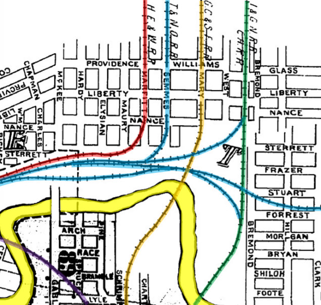
Left:
This map of north Houston shows tower locations identified by number
and shows each railroad in a different color. Except for the HE&WT (in red),
all SP railroads are illustrated in light blue; the consolidation of
SP's lines into
the T&NO (as SP's primary operating railroad in Texas) began in 1927.
Tower 26 was originally at the HE&WT crossing but was relocated to the
HB&T crossing in 1927. Tower 25 was closed shortly thereafter. SP's
passenger station used by all of its railroads was located a short
distance west of the Missouri - Kansas - Texas (MKT) crossing at
Tower 108.
Below: This annotated Sanborn Fire Insurance map from
1907 shows the tangle of rail lines along the north bank of Buffalo Bayou
(yellow) near downtown using the same color scheme as the map at left.
The Santa Fe line ("GC&SF RR") was used by HB&T, which had been created
only two years earlier. Note there were three rail bridges over Buffalo Bayou
near downtown.
|
Tower 71 first appears in a list of active
interlockers published by the Railroad Commission of Texas (RCT) in their 1908
Annual Report. This report's list dated October 31, 1907 has Tower 71 as the
final entry. The interlocker is described as a 12-function mechanical plant at
"Houston" (with no further location detail), and the commissioning date is unspecified, merely listed as
"Aug. 1907". The railroads involved with Tower 71 are listed as "H. E. & W. T --
H. B & Ter. (No. 1)". The "No. 1" was a reference to
the fact that the HE&WT and HB&T had two joint interlockers planned, the second
being the future Tower 76. It was listed the same way but designated "No. 2" in the
list published two years later. (The intervening list in the 1909 Annual Report
ends with Tower 75.) It's apparent that RCT was apprised early on that there
would be two HB&T/HE&WT interlockers in north Houston, hence the No. 1/No. 2
designations. Yet, the towers were sufficiently far apart in planning and
construction that they were not assigned consecutive
numbers by RCT.
Documents in the RCT interlocker archives maintained at DeGolyer
Library, Southern Methodist University, show that the Tower 71 implementation
did not go smoothly. As the second railroad at both crossings, it was HB&T's
responsibility to initiate the design and construction of the interlocking
towers. In response to receiving a copy of HB&T's letter dated July 31, 1907 requesting
RCT inspection and commissioning of the newly constructed tower, HE&WT asked
for technical
assistance from another SP railroad, the Houston & Texas Central (H&TC). This was HB&T's first tower, and only the
second (after Tower 26) that HE&WT had ever been involved with. An H&TC engineer, Mr. Eberspacher, responded to
HE&WT with a letter dated August 9, 1907 detailing various inadequacies in
HB&T's
design, specifically "...There are no guard rails at the derails on the HE&WT RR,
and the distant signal west on the HE&WT has no doll-pole on it while there is a
track between it and the track it governs. I also object to the semaphore lamps
furnished as they are one day burners and our standard is the seven-day lamp."
(A doll-pole was an element of a signal post design that indicated to locomotive
engineers that the signal pertained to a track that was not the one closest to
the signal.) HE&WT immediately forwarded this letter to RCT, adding a cover
letter dated the same day that said "...On account of defects enumerated in Mr.
Eberspacher's letter...", they wanted RCT to require HB&T to fix all of the
identified problems. This was presumably resolved to HE&WT's satisfaction; another document in the archives states that the Tower 71 interlocker was "placed in service" on September 11, 1907.
Northeast of Tower 71, Tower 76 was built a year later at what became known to railroaders as
"Rabbit Crossing". The published RCT interlocker list dated October 31, 1909
shows Tower 76 with a commissioning date of November 1, 1908 (implying that it
missed by one day being included in the prior year's list dated October 31,
1908.) While Tower 76 had a firm date published, Tower 71's commissioning
was still listed generically as "Aug., 1907". This did not change
until RCT's list dated December 31, 1926 was published wherein Tower 71 was
finally shown with September 11, 1907 as its commissioning date, matching the
service date found in RCT archives. This date lasted only one year, however,
being changed to July 1, 1907 for unknown reasons in all subsequent RCT
interlocker lists. RCT's final published list dated December 31, 1930 omits both
Towers 71 and 76, instead noting that these towers had been "consolidated with"
Towers 26 and 80, respectively.
In 1925, Missouri Pacific (MP) acquired
both the I-GN (which was involved with Tower 80) and the BSL&W (whose tracks
merged into HB&T's East Belt very close to Tower 76.) It also acquired the SLB&M
at this time, making MP a
half-owner of the HB&T. A letter from MP to RCT dated August 17, 1931 found
in the Tower 76 file at DeGolyer Library states
"...Tower
76 is an old mechanical plant which we feel should be replaced with an electric
installation...placed under control of operators at Tower 80 so that when the
route is lined up, a train may proceed uninterrupted over both crossings at
Tower 80 and Tower 76." It is interesting that this
letter is dated nearly a year after the last published RCT list which had
already footnoted that Tower 76 was "consolidated" with Tower 80. Perhaps that
list anticipated a consolidation that was under consideration but not yet
implemented? The most likely answer is that the date of the letter is simply
wrong, for unexplained reasons. The 1935 edition of
Railway Signaling and Communications has a comprehensive article
describing how several Houston area interlockers on the north side of town were
combined into two control points: Tower 26 and Tower 80. This
article, written by an MP
signals engineer, discusses what happened to Tower 76.
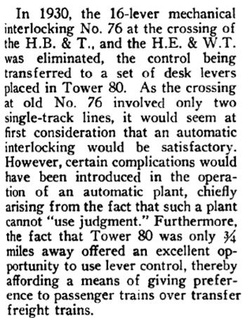 |
Left: This
excerpt from the 1935 edition of Railway
Signaling and Communications explains why, in 1930, Tower 76
was replaced by remote control from Tower 80 rather than using an
automatic interlocker. |
It is likely that Tower 71 was similar to Tower 76. Both interlockers
had 12 functions when first listed, usually indicative of a minimum function set
for an interlocker consisting of four
home signals, four distant signals and four derails. (The function count dropped
to 11 for Tower 71 in 1923.) And while Sanborn maps did not extend far enough
north to cover Tower 76 before it's demise, Tower 71 is shown (in the Sanborn
map snippet at the top of this page) as a one-story structure with a door facing
the crossing. There's also a reference to Tower 71 in the DeGolyer Library
archives as a "square tower". These clues combine to suggest that Tower 71 (and
by extension, Tower 76) was little more than a small one-story office with
levers for a manual interlocker. It is perhaps a bit surprising that Towers 71
and 76 are both listed as being manned "continuously" in T&NO's Lufkin Subdivision
timetable dated September 7, 1930. There was apparently sufficient traffic to
justify the labor expense of continuous staffing, but the physical tower seems
more like a train order office or an
unmanned cabin interlocker.
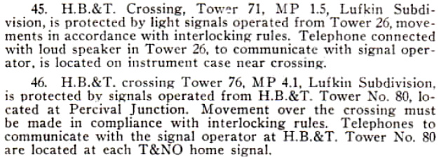 |
Left: These
special instructions pertaining to Towers 71 and 76 were published in
SP's T&NO Houston Division Timetable dated April 29, 1951,
confirming that after twenty years, Towers 71 and 76 were still remotely
controlled by Towers 26 and 80, respectively. The "telephone connected
with loud speaker in Tower 26" was an annunciator circuit (hat tip,
Tom Kline, for the term "annunciator") by which a telephone at
Tower 71 was used to send ambient noise to speakers inside Tower 26 for
the operators to hear. As explained by the aforementioned article in
Railway Signaling and Communications, "When
a train passes one of these telephone stations, the transmitter is cut
in and the noise of the passing train and the whistle signals are
brought into the towers over the loud speakers." The article
explains that this capability was driven by MP operating rules, and
implies that the telephone circuit could also be used for normal 2-way
voice communications. |
 |
Left: This map
snippet from a 1975 HB&T timetable shows that MP's former I-GN route
north from downtown had become HB&T's Freight Subdivision. For reference
to the maps above, the "BRDG." symbol at the bottom of the map is the
I-GN bridge over Buffalo Bayou. Tower numbers are not used, replaced
with HB&T's "XX" nomenclature, where AX is Tower 71, RX is Tower 210, IX
is Tower 76, NX is Tower 80, CX is Tower 26, TX is Tower 139, and SX is
the former Tower 25 interlocking. There are no
references to "Freight Subdivision" in an HB&T 1968 timetable, so presumably this
operation was
instituted in the early 1970s. By the late 1980s, "East Main" and "West
Main" were in use as names for the Freight Subdivision and North Belt
Subdivision, respectively. |
As noted above, MP became half-owner of the HB&T in
1925, acquiring the I-GN at the same time. The I-GN route had been built in 1871 by predecessor Houston & Great
Northern and was crossed at grade by the HE&WT in 1877, yet it remained
uncontrolled for decades. The most likely
reason is that the crossing was affected by the presence of Percival Yard a
half mile north of the diamond, and SP's North Yard (originally "East Yard"
in the pre-T&NO days) about 600 ft. east of the diamond. Trains on both lines would be
moving slowly anyway in the vicinity of a yard, thus there was little time
penalty for stopping at the diamond as required by state law for uncontrolled crossings. It's also worth noting that SP
timetables of the 1950s (e.g., T&NO Houston Division Timetable dated April 21, 1959)
marked the entire Houston portion of the Lufkin Subdivision (from 4.9 miles north of
Tower 76 to downtown Houston) as "Houston Yard" wherein special rules applied
regarding train movements. SP's crossing of the former I-GN finally became protected in 1961 with
an electric interlocker, Tower 210, that was remote-controlled from Tower 26.
In the late 1980s, the State of Texas began planning to widen the US 59
freeway through downtown Houston which would necessitate track relocations. The railroads cooperated with the State
by using this as an opportunity to restructure rail traffic flow from downtown to Tower 80, sharing selected
HB&T tracks and
rights-of-way with SP while abandoning others. Essentially, the plan was:
1) Abandon HB&T's West Main from south of Buffalo Bayou
to Tower 26, including transferring ownership of HB&T's bascule bridge at
Buffalo Bayou (see photos at Tower 139) to the
State which agreed to preserve it; the State also took ownership of HB&T's West
Main bridge over Interstate 10 so they could fund its removal.
2) Double track HB&T's East Main north from downtown and reroute it onto the West
Main at Tower 26, replacing the former I-GN bridge over Buffalo Bayou to support
the double track.
3) Abandon the East Main from the
former Tower 25 SP crossing north to Campbell
Street, retaining the tracks from Campbell Street to Tower 210 for car storage
and future industry support.
4) Double track HB&T's
new combined Main from Tower 26 to Tower 71, sharing the tracks with SP and
removing the Tower 71 crossing.
5) Continue the double
track of HB&T's Main from Tower 71 to Tower 210 using SP's ROW, and then
veer north, continuing the double track onto the former I-GN ROW from Tower 210 to Tower 80.
The plan was executed over many years beginning with replacement of the
former I-GN bridge over Buffalo Bayou in 1991. The project was mostly complete by the time Union Pacific
acquired SP in 1996. Although Tower 71's function was eliminated and SP was
sharing the new triple track (2 HB&T, 1 SP) from Tower 26 to Tower 210, the remainder of the
former HE&WT line from Tower 71 south to SP's main near
Tower 207 was
kept in place. An existing northwest quadrant connector allowed
southbound-to-westbound and eastbound-to-northbound movements; the diamond had
already been removed but a southeast connector remained intact. Between
April, 2014 and February, 2015, Union Pacific (UP), successor to SP, abandoned
this former HE&WT track segment. A new connection was added in the northwest
quadrant of the Tower 26 crossing to facilitate the same movements.
The
former HB&T North Belt between Tower 71 and Tower 80 remained intact until it
was abandoned between October, 2013 and February, 2014 (although isolated tracks
still exist in places.) In 2009, the remaining HB&T tracks along the former I-GN
ROW south of Tower 210 were removed. In 2018, a new elevated roadway for
Collingsworth Street was built directly over the abandoned Tower 210 crossing.
Between 1953 and
1957, the elevated US59 "Eastex Freeway" was built directly over the Tower
76 diamond, and this area has become largely inaccessible since then. Tower 76
was not directly affected by the changes implemented in the 1990s. Although
there are no connecting tracks, it remains a busy crossing of UP's Lufkin
Subdivision and HB&T's East Belt.

Above: Facing north at Tower 71
in 2006, the crossing has been eliminated and the former HE&WT tracks are
combined with HB&T's main line to curve northeast toward Tower 210 and Tower 76.
The original HB&T tracks continue due north toward Tower 80 but have been
relegated to secondary status and will be abandoned by 2014.
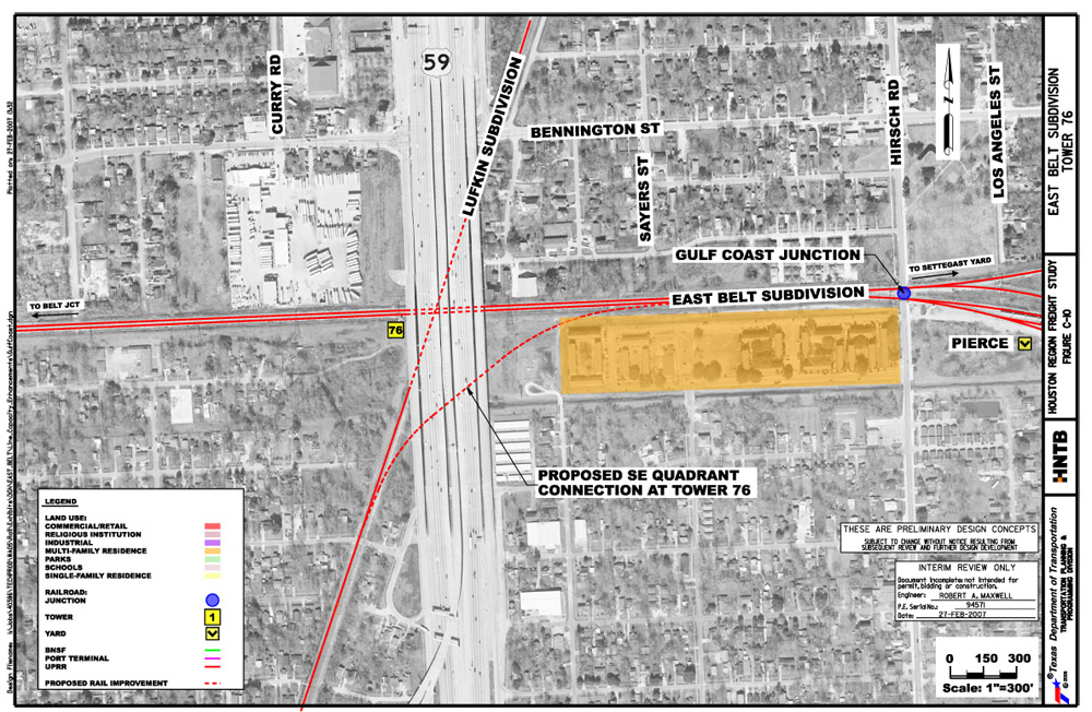
Below: In 2007, the Houston
Region Freight Study recommended adding a connecting track in the southeast
quadrant of Tower 76 to provide another route for trains between downtown
Houston and Settegast Yard, which otherwise requires movements via Tower 80 or
Englewood Yard. As of 2020, this connecting track has not been implemented.


Above: The Tower 210 equipment
cabinet was still standing in 2006, presumably no longer functional since the
red sign on the former I-GN/HB&T tracks indicates they were officially out of service
to the south. The
combined UP/HB&T main is in the background. The writing on the electrical box
attached to the utility pole says "Out of Service 4/12/02".
Below: A different equipment
cabinet now occupies the same spot, rotated 90-degrees from before. This 3-D
simulated view facing southwest is from December, 2018 Google Earth imagery
showing the recently completed Collingsworth Street elevated roadway. (Google
Maps)
