Texas Railroad History - Tower 84 - Houston (Walker Ave.)
A Crossing of the San Antonio & Aransas Pass Railway, the Houston Belt &
Terminal Railroad, and the International & Great Northern Railroad
 |
Left: Facing west,
railroad executive John W. Barriger III took this photo from the rear
platform of his private railcar on April 14, 1934. Barriger was
departing for the Rio Grande Valley on Houston Belt & Terminal (HB&T)
tracks leased from the Gulf, Colorado & Santa Fe (GC&SF) Railway. He has
just passed Tower 84 as his railcar crossed over the San Antonio &
Aransas Pass (SA&AP) Railway. Interlocking towers frequently
provided the impetus for Barriger to snap photos.
In
the margin of his film slide, Barriger wrote "Leaving
Houston southbound via N.O.T.&M. over GC&SF trackage (to Algoa)."
Barriger's train
will soon transition past the HB&T lease point and curve south, passing South Yard,
New South Yard, and Tower 81. His train will join the GC&SF main line at Alvin and
proceed five miles southeast to Algoa.
There it will turn south on St. Louis, Brownsville & Mexico (SLB&M) tracks
to the Valley.
The SLB&M was part of the Gulf Coast Lines (GCL)
group owned by the St. Louis & San Francisco ("Frisco")
Railway. During the Frisco's receivership c.1914, the GCL lines were
separated and reorganized
under the New Orleans, Texas &
Mexico (NOT&M) Railway. Missouri Pacific (MP) acquired the NOT&M in
1925. Santa Fe and the SLB&M were both 25% owners of HB&T.
(photo, John W. Barriger III National Railroad Library) |
Right: This undated
image shows Texas & New Orleans (T&NO) locomotive No. 70 northbound on
the SA&AP at Tower 84 crossing the HB&T double-track. The view is the
same as in Barriger's photo, but perhaps two or three decades
later. The track switches and crossover remain as they were in
Barriger's day.
The lettering on the side of the locomotive says "Southern Pacific".
The
T&NO and SA&AP were owned by Southern Pacific (SP.) In 1934, SP
merged the SA&AP into the T&NO, which became SP's primary
operating railroad for Texas and Louisiana lines. In Houston, the SA&AP
east of downtown
morphed into industrial tracks leading to Englewood Yard. A switch
engine pulling an empty box car would have been a common sight. (Joe R Thompson photo,
courtesy Railroad & Heritage Museum, Temple, Texas,
taken from Southern Pacific's Eastern Lines 1946 - 1996
by David Bernstein, (c)2015, North Texas Chapter, National Railway Historical
Society.) |
 |
Construction of Tower 84 was authorized in 1909 by the Railroad Commission of
Texas (RCT) to control a confluence of several rail lines
southeast of downtown Houston. The earliest of these was the Columbia Tap,
the nickname for a rail line built by the Houston Tap
Railroad in 1856. The Houston Tap's goal was to "tap" the Buffalo Bayou, Brazos and Colorado
(BBB&C) Railway, the first railroad in Texas. The BBB&C had completed a
line to Stafford in 1853 from the Buffalo Bayou
riverport of Harrisburg a few miles southeast of
Houston. The BBB&C line was about six miles south of Houston's town center, and
the Tap's connection to it created the first rail intersection in Texas at
Pierce Junction. In June, 1858, the Houston Tap
& Brazoria Railway (HT&B) acquired the Houston Tap and began building south from
Pierce Junction toward Columbia, a riverport on the Brazos
River 45 miles farther south. The tracks reached the east bank of the Brazos in 1860, and soon, the Columbia Tap
nickname for the HB&T line was adopted (and it persists today for what's left of the original track, only about fifteen miles.)
The Civil War caused the physical deterioration and financial ruin of Texas
railroads. Among many other difficulties, the war prevented the HT&B from
bridging the Brazos River into the main population center of Columbia. The
terminus became known as East Columbia and a bridge was never built.
After the War, the Columbia Tap was sold for $500 at a sheriff's sale due to its
substantial indebtedness to the State of Texas for construction loans. In 1873,
the Columbia Tap was acquired by the Houston & Great Northern Railroad
which merged with the International Railroad later that year to form
the International and Great Northern (I&GN) Railroad.
Under I&GN ownership, the Columbia Tap was rehabilitated and service resumed
between Houston and East Columbia. The I&GN was at one point the largest
railroad in Texas making it a target of rail baron Jay Gould who viewed it as a
threat to his plan to dominate freight movements between the Midwest and Houston
/ Galveston. Gould was able to acquire the I&GN in 1881, and he was able to hang
onto it during a period of financial distress in the late 1880s. After Gould's
death in 1892, his son George became I&GN President. When the I&GN went back
into receivership c.1917, the Gould family involvement ended. The I&GN emerged
from bankruptcy in 1922 as the International - Great Northern (I-GN)
and it was acquired by the NOT&M in 1924. Thus it became part of MP through MP's
purchase of the NOT&M in 1925. MP had also been a Gould railroad and it had
finally obtained independence from the Gould family after a lengthy bankruptcy.
The Galveston, Houston & Henderson (GH&H)
Railroad was another railroad that had completed a line into Houston before the Civil
War. It built the first trestle across Galveston Bay to establish
service between Galveston and Houston just prior to
the start of the Civil War. GH&H operations eventually resumed after the War,
but Galveston politicians sought additional railroad
service leading to the chartering of the Gulf, Colorado & Santa Fe (GC&SF) Railway.
Completing its own bridge between the island and the mainland at
Virginia Point, the GC&SF then routed their rail line well south of Houston
as they built northwest toward Richmond. Ostensibly headed for Colorado, more
likely the route was chosen to avoid being subject to the whims of Houston's
civic leaders who had periodically shut down the GH&H under the guise of yellow
fever quarantines. Such quarantines diverted Galveston-bound freight onto barges
and steamships on Buffalo Bayou to be delivered directly to ships in Galveston
Harbor, bypassing discriminatory fees charged by the Galveston Wharf Co. against
Houston shippers. The GC&SF eventually decided they could not ignore the growing
Houston market, so they built a
26-mile branch from their main line at Alvin into downtown Houston in 1883.
The GC&SF tracks crossed the Columbia Tap near downtown.
 |
In 1884, the
San Antonio & Aransas
Pass (SA&AP) Railway was chartered to build a line from
San Antonio to
Corpus Christi. By 1887, the main line was finished, and construction of a
lengthy branch to Houston had begun. It
was completed in 1888 with SA&AP's tracks merging into the Columbia Tap near
downtown. SA&AP
was able to terminate a three-year receivership in 1892 with the help of
Southern Pacific (SP) which offered to back interest on SA&AP construction
bonds. Because it owned a direct SA&AP competitor, the Galveston,
Harrisburg & San Antonio Railway, SP could not buy the SA&AP
without running afoul of Texas' railroad competition laws. Instead, it helped the SA&AP in every other way
possible,
including by supplying key personnel to help staff SA&AP's management
ranks. In 1903, SP admitted to unlawful stock ownership of the SA&AP
and agreed to accept financial sanctions without trial in exchange for
RCT agreeing not to revoke SA&AP's Texas railroad charter. From 1903
through 1924, the SA&AP was independent. SP was allowed to acquire it in
1925.
Left: While under SP control, the SA&AP extended its tracks
across the Columbia Tap in 1901 and built north to Buffalo Bayou. It bridged the
bayou, crossed another SP line (soon interlocked as
Tower 5) and built north to reach the
main line of SP's Texas & New Orleans (T&NO) subsidiary near
Englewood Yard. (San Antonio
Daily Express, May 29, 1901) |
In 1905, the Houston Belt & Terminal (HB&T) Railway
was chartered by four railroads to build a downtown Union Station for passengers, and
to build and / or lease tracks to establish
freight switching services around Houston. As a 25% owner of HB&T, the
GC&SF leased portions of its Houston track network to support the goal. In the 1910-1911 timeframe, four
interlocking towers
were commissioned by RCT to manage HB&T crossings with major railroads. Tower 84 was the
first of these to be planned, its purpose being to manage the convergence of the
Columbia Tap, GC&SF, SA&AP and HB&T railroads southeast of downtown.
It was followed by Towers 85,
86 and 87, all
commissioned between August, 1910 and May, 1911. These were not the first towers
built by HB&T; Towers 71 and 76 had opened in the
1907-08 timeframe, and planning for Tower 80 had
begun though it did not open until 1913.
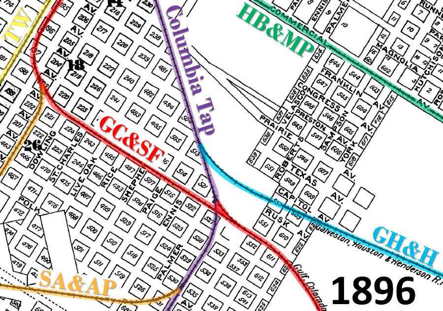
Right:
This snippet from the 1896 Sanborn Fire Insurance index map of Houston
has been annotated to show the rail lines southeast of
downtown that existed prior to the founding of the HB&T. The I&GN had
long owned the Columbia Tap, and it would also acquire the Houston Belt
& Magnolia Park (HB&MP) c.1899. The HB&MP had been chartered in 1889 to provide
passenger transit to the Magnolia Park amusement center along the banks
of Buffalo Bayou a few miles east of downtown Houston. The HB&MP also
intended to provide freight switching services, but little of this was
ever accomplished until the I&GN acquisition. I&GN wanted the HB&MP
tracks as a means of serving
the Port of Houston along the south bank of Buffalo Bayou.
The Texas
Western (TW) narrow gauge line in the upper left corner of the image did
not last long. Its tracks to Sealy were out
of service by 1900.
As of 1896, the I&GN was also litigating a
lawsuit it had filed to protect its lease of the GH&H. The GH&H was
ostensibly owned by the Missouri, Kansas & Texas (MK&T, "Katy")
Railway
because Jay Gould had bought it and assigned it to the Katy
when he served as Katy President. A year later, Gould leased it to the I&GN (where he
also was President) since the Katy had no tracks in Houston. After a
long, sordid tale of intrigue including
Gould's death in 1892, Katy tracks finally reached Houston in 1895 and
the now independent Katy sought to break the GH&H lease. The Katy / I&GN
litigation was eventually settled with each having
half-ownership of the GH&H and unlimited rights to use its tracks. |
 |
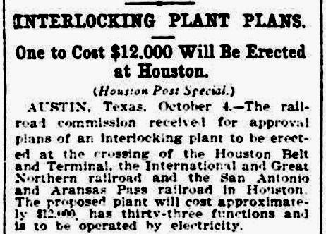
Above Left: The earliest
newspaper citation found for the planning of the interlocking that became Tower
84 appeared in the Houston Post,
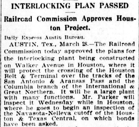
October 5, 1909. Above Center:
On March 29, 1910, the San Antonio Daily Express
reported action taken by RCT the previous day to approve the plans for the
"interlocking plant being constructed on Walker Avenue in Houston...".
What RCT "received for approval" in the
Houston Post report six months earlier was
not detailed engineering plans, merely a proposal for interlocking the Walker Ave. junction.
RCT's approval in October had enabled construction to commence for the tower
while the design of the
interlocking plant, signals and derails was in work. The final design still needed
RCT approval which was granted on March 28. The article indicates that site inspection by well-known RCT engineer
R. D. Parker was to be conducted on "Wednesday" (March 30.) Yet...
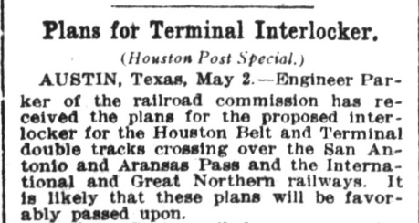
Above Right: ...the
Houston Post of May 3, 1910 reported that once again, Parker "...has
received the plans..." for this interlocker. Perhaps Parker had identified
specific concerns during his inspection for
which design rework had been required.
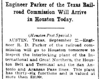
Right:
Engineer Parker eventually returned to Houston to perform final
inspection on Tower 84. (Houston Post,
September 23, 1910)
Tower 84 should have appeared
in RCT's published table of active interlockers dated October 31, 1910,
but that list ended with Tower 83. In the
table published a year later, Tower 84 was listed as a 36-function
electrical interlocking plant controlling a junction of the SA&AP,
the HB&T (which had leased the GC&SF tracks)
and the I&GN (which owned the Columbia Tap) but no commissioning date was provided. In 1916, RCT
identified HB&T as the railroad with operational responsibility for
staffing Tower 84, but the commissioning date continued to be omitted until
1924 when "February 18, 1918" was supplied. In 1928, the
commissioning date was revised to "August 10, 1910", six weeks prior to Engineer
Parker's trip to Houston for final inspection. The 1910 date is much
more in line with what is known about Tower 84, but it also implies
some sort of pre-authorization pending final inspection, perhaps not
surprising given Parker's direct involvement dating back to March of that year.
With three other HB&T interlockers, Towers
85, 86 and
87, commissioned in April / May, 1911, this
was a very busy time for the growth of HB&T's infrastructure.
The
1928 report updated Tower 84's identity to Houston (Walker Ave.)
to help distinguish it among the locations of HB&T's interlockers. When
RCT stopped publishing its list of active interlockers at the end of
1930, the final table gave Tower 84 a function count of 47, making it
the 18th largest among the 151 interlockings in that list. |
 |
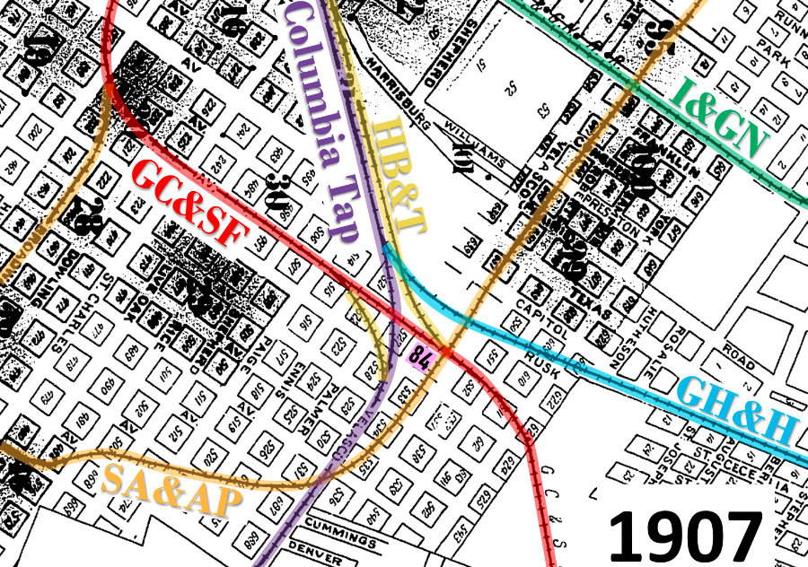 |
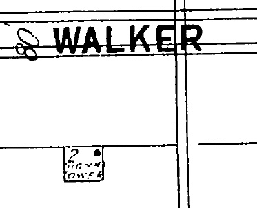
Left:
This Sanborn index map differs from the earlier graphic because it
was drawn in 1907. The future site of Tower 84 is annotated in the west
quadrant of the SA&AP / HB&T (GC&SF) diamond near the center of the
image. The track highlights do not distinguish the portions of the GC&SF that were
leased to the HB&T. Precise boundaries are undetermined but the
lease probably included most (if not all)
of the GC&SF tracks on this graphic. The new connector at the Columbia Tap / GC&SF crossing is presumed
to have resulted from HB&T's efforts, most likely related to the new
Union Station being built one mile northwest of the center of this map.
Note the "AV." label above the ampersand in "GC&SF". Off the map to the
left, that roadway is labeled "Walker", hence in 1928, RCT began
listing the location of Tower 84 as "Houston (Walker Ave.)" It was not a
thoroughfare for vehicles in the vicinity of Tower 84.
Prior
to SP's settlement with RCT in 1903 making the SA&AP independent, the
SA&AP had built a northeast extension across the Columbia Tap to a
new Buffalo Bayou bridge (off the top of the map) to reach SP's
Englewood Yard. This created five
additional diamonds: four appear on this 1907 graphic and a fifth was
immediately north of Buffalo Bayou at Tower 5.
This map also shows a new diamond (compared to the 1896 map) at the
HB&T's crossing of the GH&H, which was still half-owned by the I&GN. The
I&GN had also acquired the former HB&MP line into east Houston, and it
had continued to own the Columbia Tap since the 1870s. The blank
triangularly-shaped area near the "HB&T" label was I&GN's freight yard. |
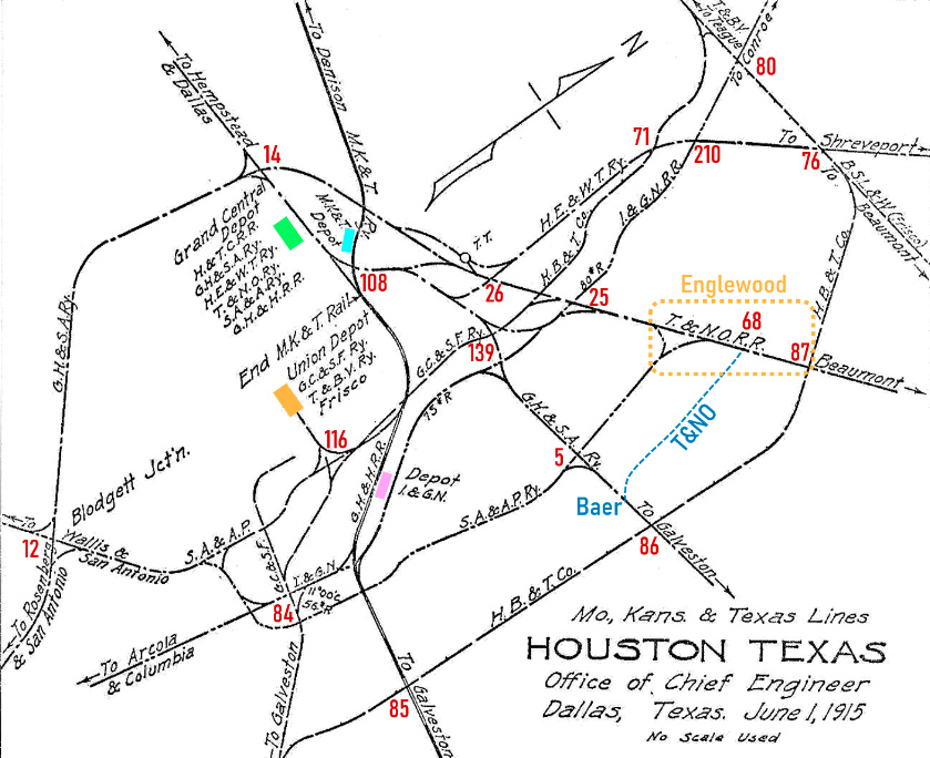
Right: This 1915
track chart from the Katy Railroad's Office of Chief Engineer
conveys the larger context of Tower 84's location within the Houston rail
network of the early 20th century.
The map has
been annotated with the numbered interlocking towers that controlled various
junctions. [Not all towers are shown, and some that are did not exist when the
map was drawn; the position of the numerals relative to nearby tracks is not
indicative of precise tower locations.] The map is rotated 45 degrees so that
Northwest is "up".
The map has colored rectangles for the four
major passenger stations that were in use at the time: orange, HB&T's
Union Station; green, SP's Grand Central Station; purple, the I&GN
passenger depot; and blue, the Katy's passenger station. SP's Englewood
Yard is the orange dashed rectangle, and the T&NO track (blue dashed
line) from the yard to Baer Junction has been added. The mapmaker omitted
it by mistake, perhaps due to confusion with the
1901 SA&AP line that paralleled it a mile to the west.
Both lines went north to the T&NO main line.
On this map, HB&T's
construction of additional tracks led to establishing several
interlocking towers around town. Towers 71,
76, 80, 84,
85, 86,
87, 116 and
139 are
all attributable to the HB&T, as was Tower 117
off the bottom of the map southwest of Tower 85. |
 |
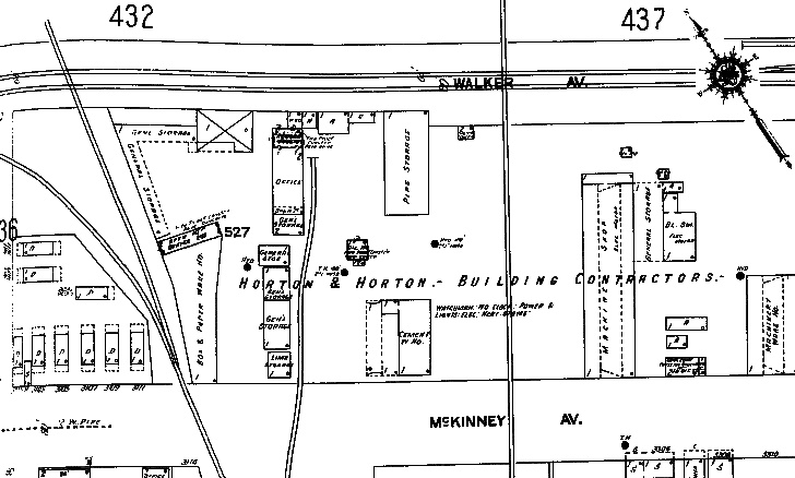 |
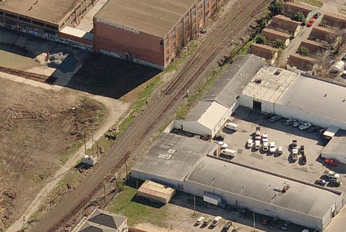
Left:
The 1925 Sanborn Fire Insurance Map of Houston shows Tower 84 located along
the HB&T tracks on Walker Ave. The SA&AP tracks are depicted as the
vertical line near the center of the image. The tower was on the
southwest side of the diamond near a "Pipe Storage" area for "Horton &
Horton Building Contractors".
Above: The cartographer identified the structure as a
two-story "Signal Tower". No external stairs are depicted but Barriger's
photo vaguely suggests they may have been on the left side of the tower
from his viewpoint. |
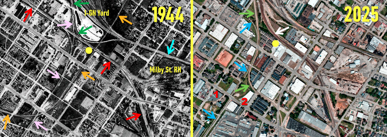
Above: This side by side
comparison of aerial images from 1944 (courtesy Texas General Land Office) and
2025 (Google Earth) shows the significant changes that have occurred over eight
decades in the vicinity of Tower 84 (yellow dot; the tower is not visible on the
1944 image at this resolution.) The tracks owned by the GC&SF (red arrows) were
leased to HB&T, hence the GC&SF was not listed as a participant at Tower 84.
HB&T built new tracks (green arrows) from Union Station paralleling the Columbia
Tap that merged into the leased GC&SF tracks near Tower 84.
It also built the Milby Street roundhouse and shops in 1909; the site remains in
use as a locomotive servicing facility. The SA&AP tracks ran along the
east side of Tower 84, crossed HB&T's leased tracks at the tower, and
crossed tracks farther north that led into the I-GN yard, including the GH&H
(light blue arrow.) The I-GN owned the Columbia Tap (pink arrows) and was also a
participant at Tower 84, implying that the tower also controlled the Columbia
Tap / GC&SF (HB&T) crossing located 400 ft. west of the tower. The I-GN
had been acquired by MP in 1925, but it continued to operate under the I-GN name
until 1956 when it was fully merged into MP.
On the 2025 image, the multi-use Columbia Tap Trail (blue arrows) has
been built upon the Columbia Tap right-of-way (ROW) extending a little over
three miles south. The trail does not continue on the Columbia Tap ROW north of the former GC&SF (HB&T)
crossing. Instead, it curves west onto the abandoned GC&SF (HB&T) ROW and terminates in approximately a half mile.
In the vicinity of the former Columbia Tap / GC&SF (HB&T) crossing, Houston's
light rail system has built tracks (light green arrows) atop portions of the
abandoned Columbia Tap ROW. Since the GC&SF (HB&T) tracks are abandoned west of Tower
84, the track coming north from South Yard and New South Yard has been
redirected (white arrow) to curve onto the original HB&T ROW toward Union
Station. The red numerals 1 and 2 mark buildings that were built with curved
sides due to the presence of SA&AP sidings, spurs and main track which curved north to pass beside
Tower 84. Aerial imagery suggests the SA&AP tracks were removed some time between 1982 and 1995,
but development in this area has rendered the former SA&AP ROW virtually
undetectable. At least through 1995, the SA&AP bridge over Buffalo Bayou was
retained for access (from the north) to a yard on the south side of the bayou,
but the bridge does not appear on 2002 imagery.
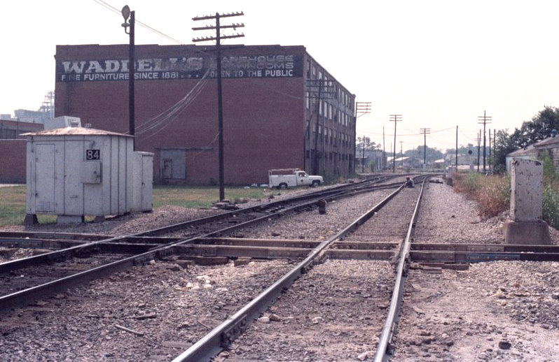
Above Left: Greg Johnson
provides this undated photo of the equipment cabinet that replaced Tower 84 with an interlocker
controlled remotely by HB&T operators. SP's former SA&AP rails cross in
the foreground. The view is east-southeast on the HB&T.
Above Right: This c.2008
bird's eye view (Microsoft Visual Earth) shows that not much is left of the
former SA&AP ROW. The equipment cabinets that appear on both sides of the HB&T
tracks above left are visible in this image, providing a location clue for the
SA&AP crossing. The Waddell's Warehouse building remains, although the sign on
the wall has changed. In 2009, the building was designated as a historic
structure by the City of Houston.
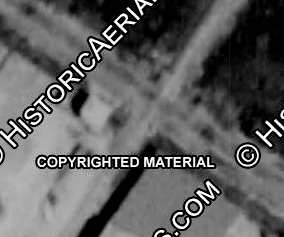 |
Left: This
1964 aerial image ((c) historicaerials.com) shows Tower 84 in the west
quadrant of the diamond casting a shadow to the northwest. It remains
standing in 1966 imagery, but 1973 imagery is indeterminate. It is no
longer present in 1976 imagery. Note the lengthy shadow cast by the
building in the south quadrant of the diamond. This is the same building
present in the foreground of the image above right. It is present on
1947 imagery but not on 1930 imagery. The functions of Tower 84
were consolidated into
Tower 117 on
June 1, 1971. On April 17, 1983, the functions of
Towers 81 and 84 were transferred to HB&T's Traffic
Operations Center at Houston Union Station.
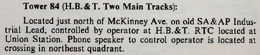
Left: This snippet from an April, 1984 SP Employee
Timetable instructs train personnel to contact HB&T's Remote Traffic
Control office at Union Station for permission to cross the HB&T's two
main tracks at Tower 84. A direct speaker-phone connection to the
operator was provided nearby. |
According to SP historian David Bernstein, Tower 84's
interlocking functions were retired in 1988, presumably in conjunction with the removal of the two
crossings that Tower 84 controlled, specifically the SA&AP (by then an industrial track
for SP) and the Columbia Tap (same for MP.) The fate of the
Tower 84 building is undetermined.
In the early 1980s, MP was acquired by
Union Pacific (UP) and operated as a wholly-owned subsidiary. In the
mid 1990s, UP acquired SP, and within a couple of years, both MP and SP had
become fully merged into UP with all operations conducted under the UP name. Of
the original four companies that owned the HB&T, three of them (the SLB&M, the
Trinity & Brazos Valley, and the Beaumont, Sour Lake &
Western) ended up as part of UP. The GC&SF was the fourth, but long before HB&T's founding
in 1905, the GC&SF
had been acquired by the Atchison, Topeka & Santa Fe (AT&SF) Railway. The GC&SF
continued to operate under its own name until 1965 when it became fully merged
into AT&SF. In the mid 1990s, AT&SF merged with Burlington Northern to
form Burlington Northern Santa Fe (BNSF.) As a consequence of these
mergers, ownership of HB&T was split evenly between UP and BNSF. It still
exists, but only as a "paper railroad" for managing financial aspects of real
estate, facilities and tracks owned equally by BNSF and UP. HB&T
isn't even based in Houston these days. Its official headquarters is a building
in Texas City that it shares with another railroad owned equally by UP and BNSF:
the Texas City Terminal Railway.
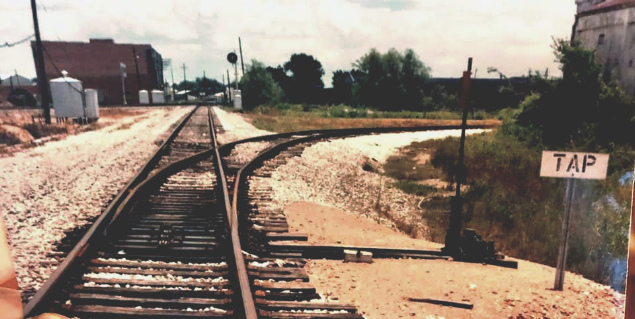 |
Left:
John Treadgold took this photo in the 1980s facing east on the HB&T
(original GC&SF) tracks toward Tower 84. In the distance, the
HB&T main merges from the left near the
Waddell's Warehouse building looming in the background. The switch for the
connector to go south on
the Columbia Tap is in the foreground. By this date, the Tap no longer
crossed the HB&T, but the equipment cabinets at
near left
mark where it did. From this distance, it is unclear whether the SA&AP
crossing was still intact.
Below Left:
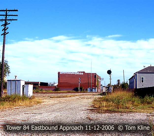
This 2006 photo by Tom Kline is taken in the same direction, closer to
the equipment cabinets. The HB&T tracks have been removed along with the
connecting track and the Tap itself (for three miles south.)
Below Right: This December, 2014 Google
Street View was captured from the new Columbia Tap Trail where it curves
south onto Columbia Tap ROW. Again, the view is east toward the
Waddell's Warehouse building and the same equipment cabinets remain in
place. What appears to be a "paved street" across the image is the
Houston Metro light rail double track. |
 |
 |
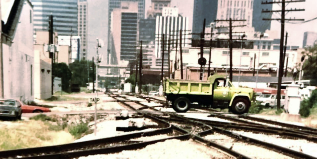
Above Left:
John Treadgold took this photo in the 1980s facing west toward downtown from a
location a bit farther east than in his previous photo. The Tap connector comes
in from the left -- note the "Tap" sign. This was the original GC&SF ROW into
downtown eventually leased and operated by HB&T.
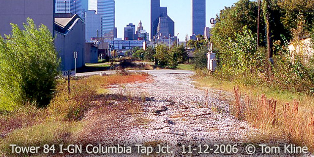
Above Right: This 2006 Tom Kline photo from nearly the
same location shows that the small bush beside
the "Tap" sign in John Treadgold's photo has either grown much larger
over twenty years or been replaced by some other volunteer weed. The tracks have
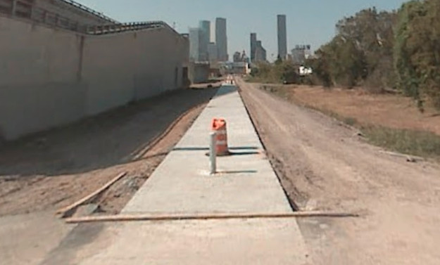
been removed along with a 3-mile segment of the Columbia Tap to the south. Below Left: Ennis
Street is the crossing visible in both of the above photos, and it provides the
location where this Google Street View was captured facing west in October,
2007. This was eleven months after Tom's photo, and it shows the Columbia Tap
trail under construction.
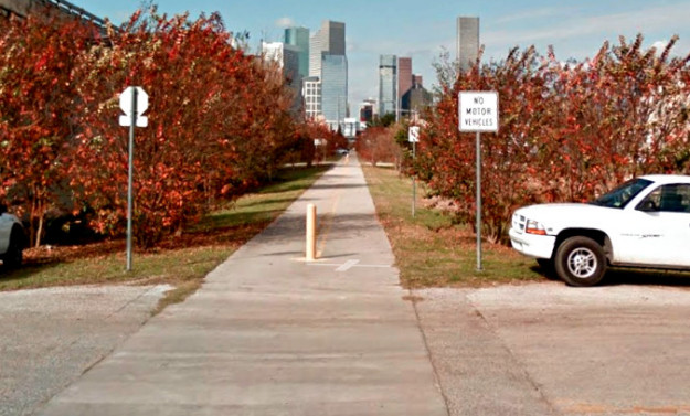
Below Right: Seven years later, this December, 2014
Google Street View from the same location and direction shows the completed
trail and the associated beautification efforts. The trail terminates a half
mile in the distance.
Above Left: Looking north from
McKinney St., the SA&AP main track was bounded by the building on the right
(which dates back to at least 1947) and the utility poles on the left. The poles
appear to be of more recent vintage. Historic aerial imagery shows that they
would have interfered with several short spur / siding tracks in this area used
for transloading railcars. Above Right:
This view looks west from Sampson St. along the former HB&T main track, now
owned by UP. The building to the right is the aforementioned Waddell's Warehouse
The equipment cabinets to the right of the tracks mark the former SA&AP crossing.
The cabinets in the center of the image beyond the curved track are the same
ones shown in the east-facing images further above where the Columbia Tap crossed the GC&SF
(HB&T) tracks.
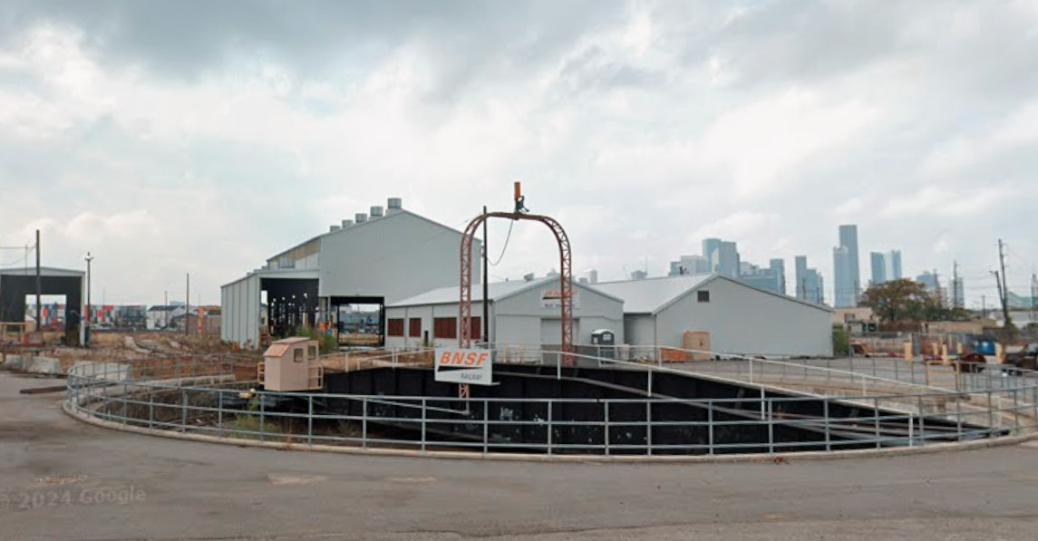 |
Left:
The turntable at the Milby Street facility remains in service for BNSF
in this November, 2022 Google Street View. This image was captured from
the location where the roundhouse originally stood. Aerial imagery shows
that the roundhouse dismantling began after 1953 and was essentially
complete by 1957. In its place, the buildings in the background -- for
parts storage, office space and servicing locomotives -- were built in
the same timeframe (but may have been rebuilt since then - they
certainly don't look 65 years old!)
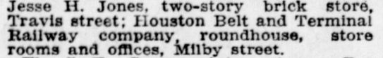
Below: This snippet from the Houston Post
of September 1, 1909 indicates that HB&T built the facility at Milby
Street c.1909. The newspaper published a lengthy list of
building permits issued by the City of Houston during the twelve months
ending the prior day, and the Milby Street facility was the last item in
the list.
 |