Texas Railroad History - Tower 137 - Big Sandy
A Crossing of the Texas & Pacific Railway and the St. Louis
Southwestern Railway
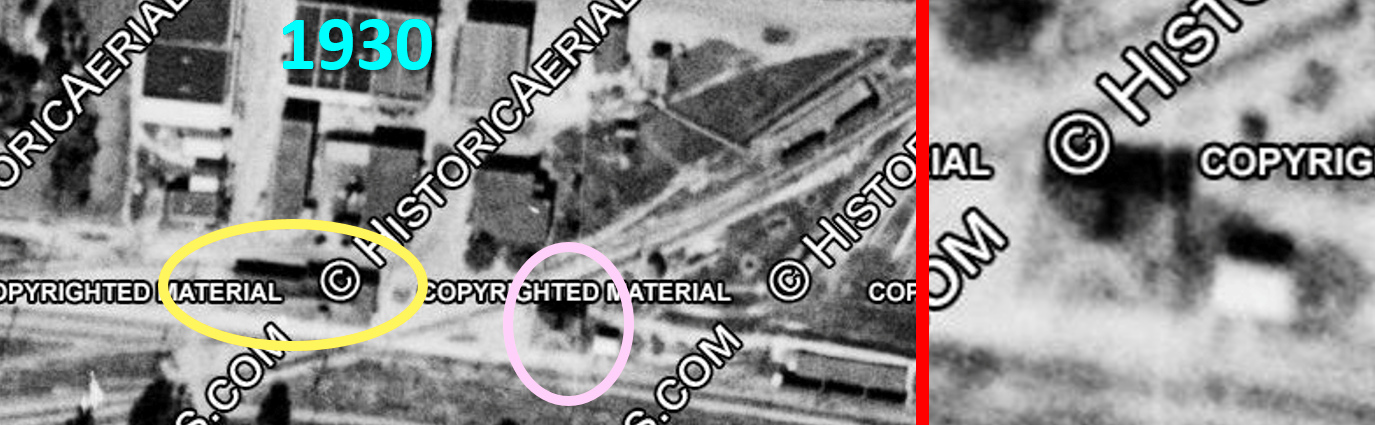
Above: This 1930 aerial image ((c) historicaerials.com)
of the Big Sandy crossing has been annotated to highlight the Union Depot (yellow
oval) and a building across the tracks (pink oval, magnification at right.)
Railroad Commission of Texas (RCT) records state that a 20-function electric
interlocker, Tower 137, was commissioned at Big Sandy on August 14, 1928. The
shape of the building and its dimensions relative to the size of the depot gives
the appearance of a standard, 2-story interlocking tower with a shed located
immediately to the east. If so, this is the only evidence of a traditional
manned interlocking tower at Big Sandy found thus far. And with no other
evidence, the duration of its existence is undetermined. It does not appear on
the next available aerial imagery from 1955, and no photos of it have been
discovered. No records pertaining to its
construction or abandonment are known to exist, nor have any written references
to Tower 137 been found other than its RCT commissioning date. If a tower
structure existed at Big Sandy, the 1930 imagery is the only evidence.
 |
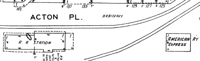
Top Left:
This 1928 Sanborn Fire Insurance map of Big Sandy shows a 1-story
American Railway Express building located in the same spot as the (pink
oval) structure above. On this basis, which is more likely? Is the
structure visible in the 1930 imagery the 1-story railway express
building, or is it a 2-story manned interlocking tower built where the American Railway Express building previously stood?
The answer is undetermined. New traditional 2-story towers were rare after 1926.
Tower 139 (Houston) qualifies, but it had
an unusual history related to Tower 89.
Otherwise, Tower 138 (Harlingen) and
Tower 159 (Mathis) are the only known
"stand-alone" 2-story interlocking towers built after
Polk's Tower (Fort Worth) in 1926. The
controls for Tower 137's
electric plant could easily have been operated from the depot which was
very close to the crossing. Along with the Sanborn map,
these facts
would argue in favor of the structure being the American Railway Express
building.
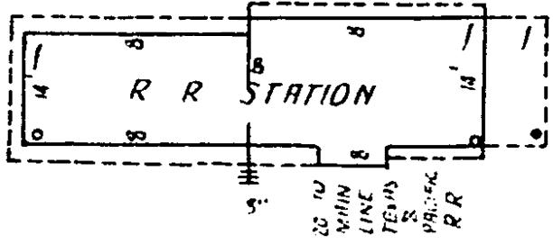
Bottom Left: The
1928 Sanborn Fire Insurance map of Big Sandy details Union Station
as a "R R Station" with an interior north / south width of 14 ft. The
notation at bottom appears to read "20 to MAIN LINE TEXAS & PACIFIC RR",
presumably noting that the platform was 20 feet from the T&P main line
tracks. Based on this drawing, the station was approximately 20 ft.
by 70 ft. including the exterior platform.
Assuming the depot was
~ 20 ft. wide, then what to make of the (pink oval) structure across the
tracks? Visually, the building appears to be about the same width as the
depot, and is square. Would a 20 ft. x 20 ft. roof outline make sense
for an American Railway Express facility? Would it have been built with
the classic trapezoidal roof appearance often used for interlocking
towers? Under magnification, the Sanborn Map
appears to show "14" (rotated 90 degrees) along the west wall of
the American Railway Express building (compare to an identical notation
on the depot's east wall.) If so, a mere 3-ft. overhang on each side
would produce a 20 ft. x 20 ft. roof outline. |
 |
 |
 |
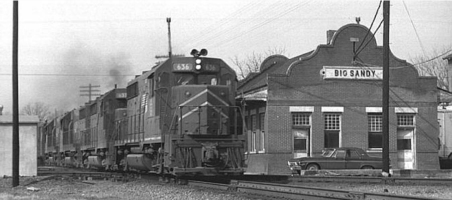
Above Left: Missouri Pacific
#636 crosses the diamond at Big Sandy as it passes the east end of the depot. The train
is eastbound toward Longview on the main line of the Texas & Pacific (T&P)
Railway.
The cabin at far left housed interlocking plant electronics. (undated
photo, Chuck Harris collection)
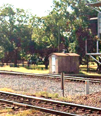
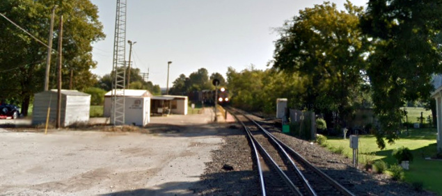
Above Right:
Viewed from the opposite direction, this
2023 Google Street View shows an interlocking cabin standing at the same
location, very likely the same one adjacent to the same utility pole as
in Chuck Harris' photo.
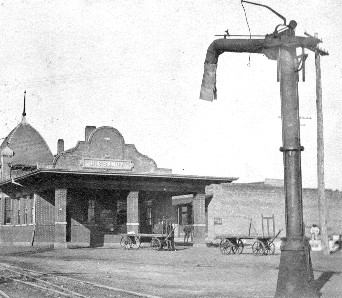
Left:
After the Union Station at Big Sandy was destroyed by fire on January 25,
1906, this new depot was built and is the progenitor of the
depot in Chuck Harris' photo. There was an east end porch that has since been removed, and there
was a dome
on the south side of the building that is no longer present. The tracks
of the St. Louis Southwestern Railway are barely visible adjacent to the
baggage wagons, crossing the T&P main line at an acute angle. A 1956
photo by H. D. Connor (bottom of page) shows the dome intact but the
east end porch removed. (Chino Chapa
collection) |
The impetus for the first railroad at Big Sandy began
with the idea of building a railroad across Texas to be part of a projected
southern transcontinental route. This was prior to the Civil War, years before
the first Transcontinental Railroad was built, a period when the Texas Legislature
somewhat freely granted state charters to railroads promising to build across
Texas. There were two competing concepts. One envisioned tracks diagonally
across the state from the Arkansas border to El Paso.
In the opposite direction, tracks would extend diagonally across Arkansas and
Missouri to reach St. Louis, expected to become the major rail gateway between
the east coast and the western U.S. The other concept was to build rails
connecting Atlanta, Vicksburg and Shreveport, more or less a straight line, with
Marshall, Texas, and then continue laying track westward across the state to El Paso.
On March 3, 1871, Congress granted a Federal railroad charter to the Texas Pacific (T&P) Railroad (renamed
Railway a year later) for the purpose of building a transcontinental rail line from
Marshall to San Diego, California. The Texas Legislature authorized the T&P to
acquire two defunct railroads in northeast Texas, and a year later, the T&P
acquired the assets of another northeast Texas railroad out of foreclosure. By
the end of 1873, new construction plus the acquired assets resulted in the T&P
having three main track segments: 1) from the Louisiana border through Marshall
and Longview to Dallas; 2) from Marshall north
through Jefferson to the newly founded town of
Texarkana on the Arkansas border; and 3) fifty-four miles of track from
Sherman east to Brookston, building in the direction of Texarkana. For this
segment, starting
construction at Sherman was deemed the better approach because materials could be shipped
there from the Port of Galveston using the
Houston & Texas Central (H&TC) rail line out of
Houston. The H&TC had reached Sherman in 1872 and continued building north
to Denison. The T&P completed the tracks from
Brookston to Texarkana in 1876, and that same year, it extended its line
westward from Dallas to Fort Worth. The T&P was
following a two-track approach the Legislature had envisioned, with a southern
line from Shreveport through Marshall to Dallas, and a northern line running
west from Texarkana to Sherman and beyond. In the east, the two lines were
linked by the tracks between Marshall and Texarkana. In the west,
Fort Worth eventually became the target for where
the north and south lines would merge. From there, a single line west to El Paso would be built.
| Right:
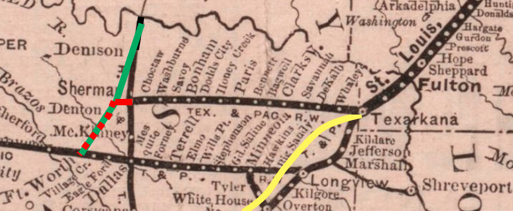
The is a snippet from an 1877 map (Texas General Land Office) showing tracks in the vicinity of
Texarkana. It shows the T&P's lines in Texas: one going west from
Texarkana to Sherman, and another going south from Texarkana to
Marshall, then turning west through Longview, Dallas and Fort Worth (and
beyond, although the T&P had yet to build west of Fort Worth in 1877.)
Two International & Great Northern (I&GN) lines are shown: southwest from Longview
continuing off the map to Palestine, and southeast from
Mineola through Tyler to Troup (near Overton.) The map shows the H&TC north / south line through
Dallas and Sherman to Denison. At Denison,
the H&TC connected to the Missouri, Kansas & Texas ("Katy") Railway
which had bridged the Red River from Indian Territory (Oklahoma). The
map annotations show selected post-1877 construction. The red line is
the T&P between Sherman and Fort Worth, built to reconnect the T&P's two
parallel main lines. The Katy (green) shared this line south to Fort
Worth from a meeting point at Whitesboro. The yellow line is the Texas &
St. Louis Railway from Texarkana southwest to Tyler, continuing off the
map to Athens and
Corsicana. Big Sandy
appears on the map where this line crossed the T&P. |
 |
About the time this map was published in 1877, the
Tyler Tap Railroad
completed a narrow gauge line between Tyler and Big
Sandy Switch, a new settlement at a junction with the T&P named for nearby
Big Sandy Creek. The idea was to "tap" the T&P at Big Sandy Switch for the
benefit of the citizens of Tyler. The Tyler Tap had been chartered in late 1871
by Tyler citizens concerned that other towns with railroads would succeed at
Tyler's expense. Before
the Tap's construction had even started, the fears of Tyler residents being
orphaned without a railroad were allayed by the construction of a Houston & Great Northern (H&GN)
rail line from Troup through Tyler to Mineola in 1873.
[The H&GN became the I&GN when its merger with the International Railroad
was approved by the Legislature in 1875.] The Tap's construction finally began
in 1875, and it took two years to reach Big Sandy Switch, a distance of 21
miles. Unlike the T&P, the
Tap was narrow gauge, hence there was
no direct connection at Big Sandy Switch. Instead, the Tap paralleled a T&P siding for a
quarter mile to facilitate transferring cargo between the two
railroads. By the early 1880s, the settlement around Big Sandy Switch had grown large
enough to apply for a post office. At least by 1889 and likely earlier, a post
office was
granted under the name Big Sandy.
In 1880, under new ownership and renamed the
Texas & St. Louis (T&SL)
Railway, the rail line from Tyler to Big Sandy was extended north across the T&P toward
Pittsburg and Mount Pleasant, eventually reaching
Texarkana, a total distance of 107 miles.
Publicizing its planned expansion, a T&SL ad in the
Galveston Daily News of January 21, 1881 coined
the phrase Cotton Belt Route. Soon thereafter, Cotton Belt became the
nickname that would stick with the T&SL and its successor railroads for the next
110 years. The T&SL continued
building from Texarkana diagonally across Arkansas and Missouri, and by late
1883, it had reached Bird's Point on the Mississippi River. There, barges moved
railcars across the river to Cairo, Illinois. The lengthy track segment from
Texarkana to Bird's Point overextended the T&SL's
finances and it went into into receivership in January, 1884.
By 1872, east coast rail
baron Jay Gould had begun to shift his attention to the west and southwest,
planning a major presence in Texas. It offered ports on the Gulf through
which commodities from Midwest and Plains states could be exported, plus the potential for
trade with Mexico. In 1879, Gould
acquired control of the Missouri Pacific (MP) Railroad based in St.
Louis. For his southwest expansion, railroads would be merged by lease
or acquisition into MP. In December, 1879, the selection of Gould as
President of the Katy was accomplished by his loyalists who had
infiltrated Katy management over several years at Gould's behest. The
plan had been hatched because the Katy's diluted stock
prevented Gould from acquiring controlling interest; there was simply
not enough Katy stock circulating on the open market. Gould leased the Katy to MP
as part of his larger plan, but he did so under terms that facilitated moving Katy
profits into MP's coffers where his significant MP stock ownership would
produce substantial personal dividends.
Gould's objective was to acquire the I&GN,
quickly becoming Texas' largest railroad. To do so, he needed the T&P because it provided a critical link between
Longview and Texarkana for the I&GN's
route to St. Louis. Financing had left the T&P stalled at Fort Worth,
so Gould struck a bargain. He offered to build the T&P west of Fort Worth
at his own expense in
exchange for $40,000 in T&P stocks and bonds for each mile
completed. Track-laying began in April, 1880, and
within a year, Gould owned controlling interest in the T&P. He became
its president and proceeded to lease it to MP.
To gain leverage over the I&GN, Gould also
wanted the St. Louis, Iron Mountain &
Southern (SLIM&S) line between Texarkana and St. Louis. Under
pressure from Gould, the SLIM&S ownership
capitulated in December, 1880 and sold him a large block of stock,
giving him about 30% of the company. They did not further resist his
control, and the SLIM&S was soon leased to MP. With Gould
controlling both Texas gateways to St. Louis (at Texarkana and Denison) the I&GN
recognized its
fate and sold out in June, 1881 in an exchange for Katy stock.
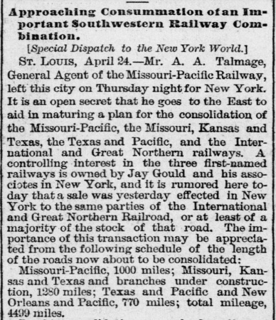
Right: A full month before
Gould's acquisition of the I&GN, the
Galveston Daily News of April 30,
1881 reported speculation by New York papers that discussions were being
held to consolidate Gould's MP and Texas railroads, including the I&GN.
The article was incorrect regarding Gould's ownership of the Katy; he
was President, but he lacked financial control. |
 |
In February, 1886, the
St. Louis, Arkansas & Texas (SLA&T) Railway was created by the T&SL's bankruptcy
judge to become the new Cotton Belt, going against the advice of T&SL
President Sam Fordyce who believed residual operational issues would inhibit
profitability. Despite Fordyce's concerns, the receivership ended and the SLA&T
immediately converted its tracks to standard gauge and established rail
connections with the T&P at Big Sandy. The SLA&T proceeded to build new
branch lines into north Texas from its main line to compete with Gould on
traffic from Sherman and
Fort Worth. This culminated in a secret agreement between Fordyce and Gould in
1888 for the Cotton Belt and MP to cooperate on traffic through Texarkana. Gould
began to gain financial leverage over the SLA&T with loans and stock purchases,
positioning him to guide its reorganization when it became insolvent in 1889 (as
Fordyce had predicted.)
In 1891, the SLA&T bankruptcy plan created a new
railroad dominated by Gould. It was known as the St. Louis Southwestern Railway
(SLSW or SSW), but more commonly just Cotton Belt (which Gould had wanted
to be the railroad's official corporate name; the judge chose otherwise.) Gould installed his younger son Edwin
as President of the SLSW, and Edwin held that title until his retirement in 1925.
A series of ownership changes in the late 1920s resulted in the Cotton Belt
becoming a subsidiary of Southern Pacific (SP) in 1932, which continued to operate it
separately until it was merged in the 1990s.
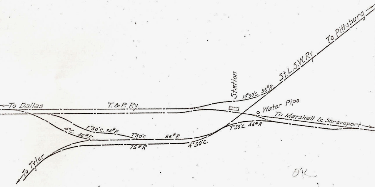 |
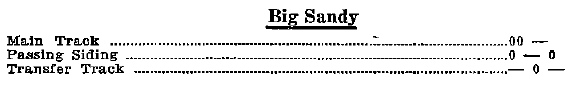
Left: Although the
Katy had no tracks
at Big Sandy, its Chief Engineer's office drew this 1915 track chart of Big
Sandy (Ed Chambers collection). There were yard tracks in the area
between the two parallel main lines.
Below: This snippet
from a 1907 post card shows the "water pipe" noted on the track chart.
 |
Where the Tower 137 interlocker
controls were located is undetermined, but that the controls
were operated manually for many years
is undisputed. A joint MP / T&P Employee Timetable (ETT) issued July 30, 1967 listed the
interlocker at Big Sandy as manual. It had not yet been converted to an
automatic plant though others listed in the same ETT had been converted (e.g.
MP's ex-I&GN crossing of the Cotton Belt at
Jacksonville.) Automatic plants had been approved by RCT
beginning in 1930.
In MP's ETT dated October 31, 1976, Big
Sandy was listed with an automatic interlocking plant, although this could have
occurred after 1967 but before the T&P was integrated into MP.
 |
Above: An
operator would press buttons or throw levers to effect switch changes granting movements
for locomotives when they signaled these whistle codes. (T&P
Employee Timetable, March 26, 1944)
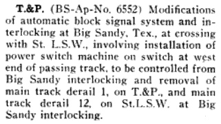
Far Left: The December, 1944 issue of
Railway Signaling noted that the T&P
was implementing various signal and switch changes at Big Sandy. The new
power switch at the west end of the passing track would be "controlled
from Big Sandy interlocking" implying that local operators remained
employed there.
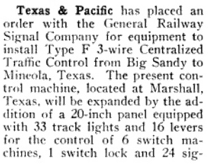
Near Left:
The September, 1950 edition of The
Signalman's
Journal carried this item reporting the T&P's planned
installation of Centralized Traffic Control from Big Sandy to Mineola.
The article noted that this would expand the "present control machine,
located at Marshall" which suggests that Big Sandy's signals and
switches were already under remote control from Marshall. Thus, while
the interlocking was manually controlled until the mid-1970s, the
operators were at Marshall, not Big Sandy, at least by 1950. |
Jay Gould died in 1892 and his
elder son George became
President of the I&GN and the T&P. By 1917, the Gould rail empire had
been pared back significantly; the family was no longer involved with MP or the T&P,
and its involvement with the I&GN would soon come to an end. Out of receivership and freed from
Gould family control, MP wanted to acquire both the I&GN and the T&P as a means
of entering the Texas market through the Texarkana connection. In 1918, MP began
to purchase T&P stock on the open market with an eye toward acquiring a
controlling interest, which it achieved in 1930. MP elected
not to take operational control of the T&P;
instead the two railroads coordinated their operations. On January 1, 1925, the Interstate Commerce Commission allowed MP
to acquire several railroads including the I-GN (no longer "I&GN"; the '&' had been dropped when
a new company was created to end the bankruptcy in 1922.)
In 1933,
MP went into a lengthy receivership and operated for more than two decades under
court supervision. It finally emerged from bankruptcy in 1956, dissolving the
I-GN and integrating its operations under the MP name. The T&P and MP continued
their cooperative relationship which remained essentially unchanged into the
1970s. In 1976, MP finally exercised its ownership control over the T&P by
dissolving the company and merging its assets into MP. In 1982, Union
Pacific (UP) acquired MP but continued to operate it a subsidiary under the
MP name. In the early 1990s, SP finally merged the Cotton Belt and
integrated its operations. In 1996, SP was acquired by UP, and a couple of years
later, UP operationally merged SP and MP so that all activities were conducted
under the UP name. Today, both
lines at Big Sandy are UP main lines that continue to see significant traffic.
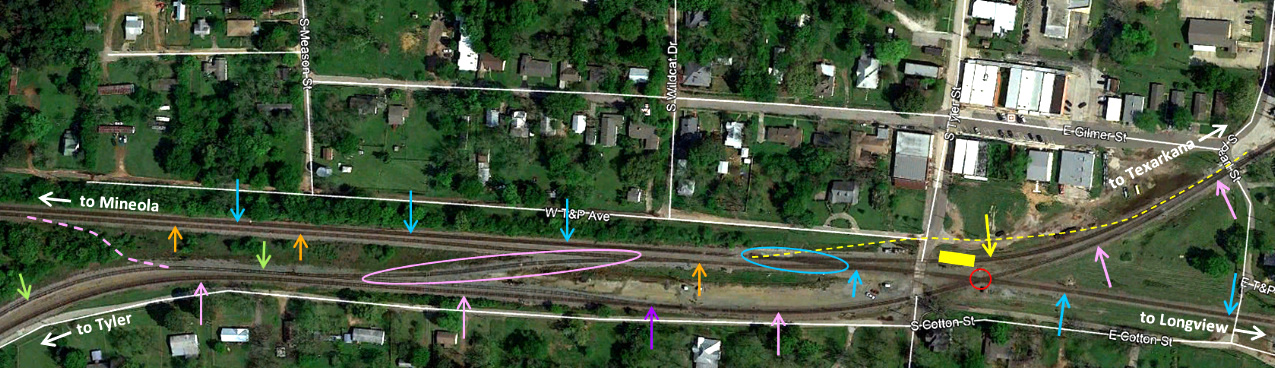
Above: Much has changed in Big Sandy over the past
century. This Google Earth image from April, 2019 has been annotated to explain
the track topology and mark the location of the former Union Station. The
station (yellow rectangle) served both railroads, hence it was inevitably near
the Tower 137 diamond (red circle). Because the south edge of the depot was only
20 ft. from the T&P main line (blue arrows) the original
interchange track (yellow dashed line) between the T&P and the Cotton Belt
passed north of the station.
As of 2020 (and likely for many years prior), two switches have defined the
endpoints of a 100-yard segment of main line track (blue oval) immediately west
of the Tyler St. grade crossing. The west switch is where the interchange track
(yellow arrow) departs the former T&P main line to transition to the former
Cotton Belt tracks. The east switch is for a siding (orange arrows) that extends
7,500 ft. to the west. The former Cotton Belt main line (pink arrows) also has a
siding (green arrows) accessed by a switch (purple arrow) located 750 ft. west
of the diamond. A crossover track (pink oval) provides a connection between the
two sidings. As of 2020, this crossover track is manually switched and has
derails in place. It may occasionally be used to facilitate westbound-to-southbound movements that occur at Big Sandy.
Most often, those movements are accomplished
by bringing the rear of the westbound train past the interchange switch, backing
up onto the interchange track until the lead locomotive reaches the former
Cotton Belt main, and then pulling forward on the main to proceed south to
Tyler, all of which can be accomplished using remote controlled switches. At
various times (but not continuously) dating from the 1915 track chart through
1996 aerial imagery, there has been a connecting track (pink dashed line) at the
west end of Big Sandy between the two sidings. This track provided an alternate
connection for southbound-to-westbound and eastbound-to-northbound movements.
This was necessary when the connecting track behind the depot was removed
(likely for safety reasons.) When the new connector was built after the depot
was removed, the west end connecting track was removed.
The former T&P
line is now UP's Mineola Subdivision. The former Cotton Belt line is now UP's
Pine Bluff Subdivision north of the diamond and its Corsicana Subdivision south
of the diamond. As the vast majority of movements on the Cotton Belt come south
on the Pine Bluff Subdivision, there is a crew change hut a short distance north
of the Pearl St. grade
crossing (at far right) where most (but not all) southbound trains stop. From there, trains continue onto
the Corsicana Subdivision or take the interchange track to go west onto the
Mineola Subdivision.
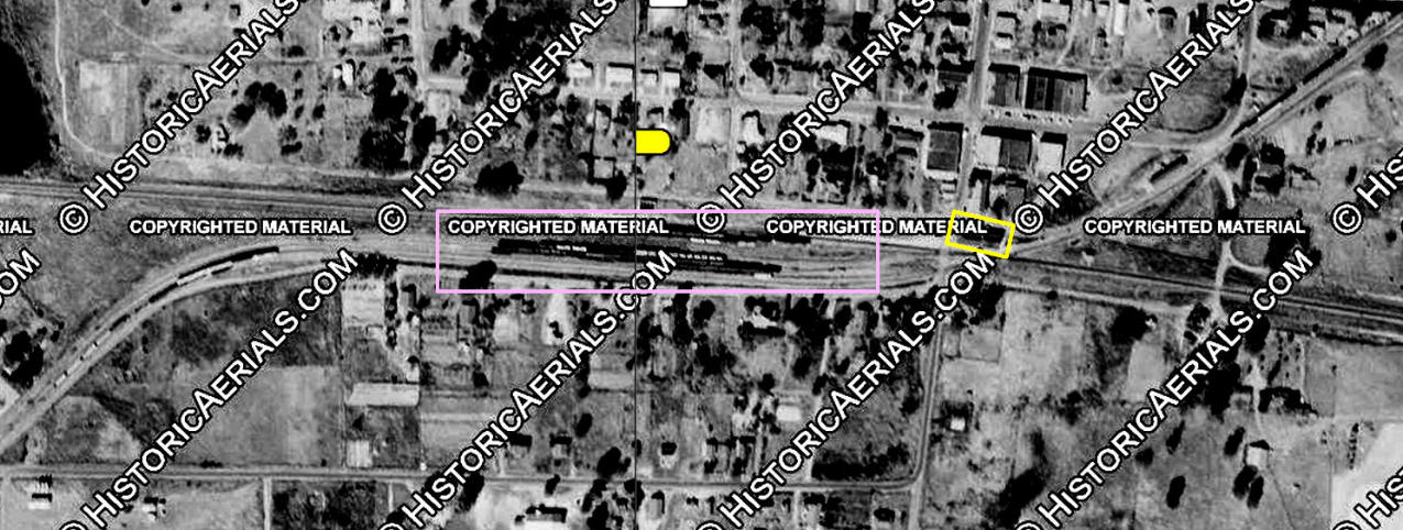
Above:
This annotated composite image from 1955 ((c) historicaerials.com) shows the
passenger station (yellow rectangle) and an interchange yard (pink rectangle).
By this time, the original interchange track north of the station had been
removed. At least by 1996 (the next historic aerial after 1957),
the interchange yard had been removed, replaced by a connecting track between
the two sidings at the west end of the former yard (pink dashed line above.) By 2004 (the next historic
aerial after 1996), that connecting track had been removed, perhaps because it
duplicated the facility for southbound-to-westbound (or eastbound-to-northbound)
movements provided by the interchange track north of the diamond. Instead, a new
interchange track between the two sidings had been installed (in the "opposite"
direction), apparently the same one that exists
today (pink oval farther above.) The lake that is barely visible north of the former T&P tracks
at far left is Big Sandy Lake, constructed by the T&P to provide water for steam
locomotives.
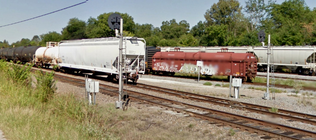
Google Street Views of Big Sandy, September
2013

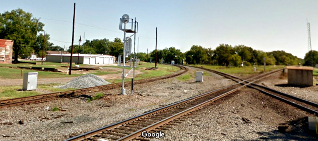
Above Left: This view to the
west on the Mineola Subdivision from the Tyler St. grade crossing shows the
siding switch in the foreground. The Pine Bluff Subdivision connecting track
comes in at right and merges with the main line approximately 100 yards west of
the siding switch. Above Right:
This view from the Tyler St. grade crossing is to the northeast, with the acute
angle diamond in the foreground and the connecting track to the left. The
Mineola Subdivision crosses the diamond left to right; the Corsicana / Pine Bluff
Subdivisions cross right to left. An
interlocker equipment cabinet (of ancient vintage) sits to the right of the
diamond.
Below Left:
The five tracks visible (from nearest to farthest) are the Corsicana Subdivision
main, the Corsicana Subdivision siding, the siding interchange track, the
Mineola Subdivision siding, and the Mineola Subdivision main line.
Below Right: With a southbound train approaching, this view is
to the northeast along the Pine Bluff Subdivision showing the crew change
facility. The switch in the foreground is for the connector to the Mineola
Subdivision.
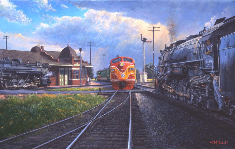
Above Left: John Winfield's
beautiful painting of the junction at Big Sandy shows Union Station with the
dome.
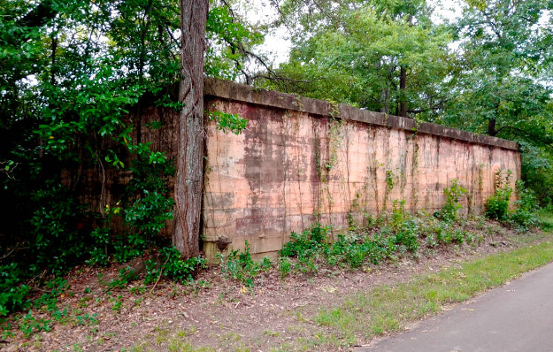
Above Right: Having
built Big Sandy Lake to provide a water source, T&P built a massive water tank
trackside less than a half mile from the lake. (Stanley Fisk photo, Sept. 2020)
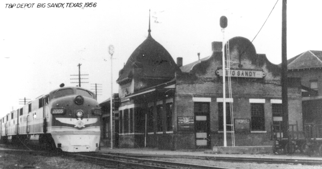 |
Left: This H.D.
Connor photo of the Big Sandy depot was taken in 1956 as an eastbound
T&P passenger train crossed the diamond. This image of the depot shows
the evolution from its original construction after the 1906 fire. The
dome remains in place, but the east porch has been removed. The date of
the final demise of the depot can be narrowed to the 1985 - 1996
timeframe based on aerial imagery. |

Last Revised: 10/23/2025 JGK
- Contact the Texas
Interlocking Towers Page.