Texas Railroad History - Tower 18 (Joint Track) and Tower 60 (North Fort
Worth)
Two Towers on the
North Side of Fort Worth
 |
Left: When Tower 60 was
commissioned in 1905, there's a reasonable probability that it was not this building. Photographed by Gary
Morris in October, 1976, it
doesn't really look seventy years old, but more significantly, its brick construction
would have been substantially out of character for Santa Fe, the railroad that built
it. All other towers built in Texas by Santa Fe in the early days used wood
construction, e.g. Tower 19
which opened two years earlier and Tower 52
which opened a year earlier.
Definitive proof of what kind
of tower structure might have preceded this one (and
if so, where it was
located) is lacking.
The location of Tower 60 was identified by the Railroad Commission of Texas (RCT) as "North Fort Worth", the town in which it was located.
The town didn't last long, but RCT never changed the reported location of the tower for the
duration of its existence. |
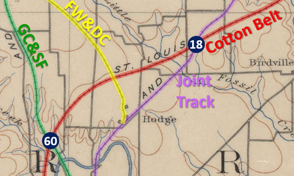
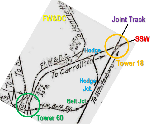
Right:
Annotations on this 1889 topographic map of Tarrant County show the
(future) locations of Tower 18 and Tower 60 roughly four miles
apart. This was a semi-rural area, but Tower 60 was less than four miles
north of downtown Fort Worth.
Four railroads had already laid tracks
into the vicinity by 1889. They were: the Fort Worth & Denver City (FW&DC) Railway;
the Gulf, Colorado & Santa Fe (GC&SF) Railway; the St. Louis, Arkansas &
Texas ("Cotton
Belt") Railway; and the "Joint Track" built by the Texas & Pacific Railway
that was shared with the Missouri, Kansas & Texas Railway under a long term rights agreement.
Commissioned in 1903, Tower 18's location in RCT's annual interlocker
summary report was stated simply as "Joint Track". |
 |
The origin of the name Hodge as applied to an
area near the stockyards in north Fort Worth has not been determined. The
earliest newspaper reference found thus far is from the Fort
Worth Daily Gazette of September 24, 1883 where Hodge is mentioned as a
locale "...about four miles north of this city." in the context of a community where someone lived. At the end of 1927, the
Railroad Commission of Texas (RCT) reported Tower 18's
location as "North Fort Worth (Hodge)" even though Tower 18 was more than two miles away
from both of the places that traditionally had been referenced as Hodge by the
railroads. The first of those was
a switch on the Joint Track where the Fort
Worth & Denver City (FW&DC) Railway began building north toward Wichita Falls
on November 27, 1881. (In 1951, "City" was dropped, becoming simply the "FW&D".) At some point, the switch became known as
Hodge Junction,
but whether Hodge applied to the general area when construction began is undetermined
(the 1889 map has the label Hodge near the
switch.) The other Hodge was about
a mile north of Hodge Junction
where tracks of the St. Louis, Arkansas & Texas (SLA&T, "Cotton Belt")
Railway
were built across the FW&DC in 1888. Northeast of both Hodge and
Hodge Junction,
Tower 18 opened in 1903 where the Cotton
Belt had crossed the Joint Track.
The story of the Joint
Track begins with rail construction into Fort Worth c.1876 belonging
to the Texas & Pacific (T&P) Railway, a Federally-chartered
railroad ostensibly
building from Texarkana to San Diego. By the end of
1873, new construction plus acquired assets had resulted in the T&P having
tracks between Texarkana and Dallas via Marshall and Longview
(the "south line".) The T&P had
also built fifty-four miles of track from
Sherman east toward
Texarkana (the "north line") that would be completed in 1876, the same year the T&P
extended its tracks west from Dallas to Fort Worth.
The T&P had chosen to build eastward from Sherman because the Houston & Texas
Central (H&TC) Railway had service to Sherman from
Houston providing a means of shipping rail and other construction materials
brought in through the Port of Galveston. The T&P's strategy was
based on having parallel
north and south main lines out of Texarkana into west Texas. The north line through Sherman
became known to the public as "the Transcontinental" as it was expected to
become the main route extending beyond west Texas.
At Texarkana,
the T&P had laid out the Texas side of town in 1873 while awaiting arrival of the
Cairo and Fulton (C&F) Railroad, a company chartered in Arkansas. The
C&F would provide a direct route to St. Louis through its connection with the
St. Louis & Iron Mountain Railway at the Arkansas / Missouri border. C&F rails reached Texarkana
in January, 1874, connecting with
the T&P. Later that year, the C&F and the St. Louis & Iron Mountain were
combined and
reorganized into the St. Louis, Iron Mountain & Southern (SLIM&S) Railway.
C&F investors had also chartered the International
Railroad in Texas in August, 1870 to become an extension
of the C&F through Austin
and San Antonio to
Laredo. The goal was to create a major route for international trade between St.
Louis and Mexico via Texarkana. Because the T&P had planned for its south line
out of Texarkana to pass through Longview, the International elected to start
its line at Longview and build southwest, relying on the T&P to cover the
gap to Texarkana. The International's construction headed toward Palestine where the main
line of the Houston & Great Northern (H&GN)
Railroad from Houston was expected to
terminate. Both railroads saw the synergy of a combined company so they merged
to create the
International & Great Northern (I&GN) Railroad. As soon as both
railroads reached Palestine, the I&GN would have a
route from St. Louis to Houston / Galveston. As the I&GN continued building
toward Laredo, it evolved
to become Texas' largest railroad.
 |
Left: Cobb
Digital Map Collection, Texas General Land Office, 1877
The most
prominent feature of this map is the bold line of the SLIM&S running
northeast out of Texarkana toward St. Louis. The T&P's two lines out of
Texarkana, to Sherman and Fort Worth, respectively, are also bold. Even
at this stage of construction, it is obvious that the T&P lacked a means
of connecting its north line and south line unless additional
construction was accomplished. Outside of T&P control, the H&TC's north / south line
intersected the T&P at both Dallas and Sherman. North of Sherman at
Denison, the H&TC's connection to the Missouri, Kansas & Texas
("Katy") Railway provided routes from Dallas through Oklahoma, Kansas
and Missouri to Kansas City and St. Louis.
As of 1879, lack of
capital had stalled the T&P's construction at Sherman and Fort Worth,
presenting East Coast rail baron Jay Gould with a prime
opportunity to take over the T&P. Gould was shifting his focus to the
Midwest and Texas, so he established a syndicate to purchase the stock
of T&P President Thomas Scott for $3.5 million. Gould offered to lay
T&P's tracks from Fort Worth to El Paso at his expense in exchange
for $20,000 in T&P stock and $20,000 in T&P bonds for each mile
completed. With the offer accepted, Gould restarted T&P construction
west from Fort Worth, and as the work proceeded, Gould progressively
gained financial control of the T&P with each mile built. By the summer
of 1880, he was effectively its CEO, and he was formally named T&P
President in April, 1881. |
Gould made two other
strategic moves in 1879. He bought a controlling interest in the Missouri
Pacific (MP) Railroad based in St. Louis, and he cleverly arranged to be
named President of the Katy in December, 1879, giving him control of the Katy's
Red River bridge. [It was clever because Gould had virtually no ownership stake
in the Katy, but he had managed to infiltrate his henchmen into Katy executive
ranks over several years.] In 1880, Gould acquired a 30% stake in the SLIM&S,
enough for its management to agree to lease the railroad to MP in December,
1880. That same month, Gould also leased the Katy to MP. Because Gould owned
little Katy stock, the lease was structured so that Katy profits
could be siphoned into MP where Gould could
benefit from dividends due to his large ownership stake, much to the detriment of Katy stockholders.
The
Katy had reached Denison in 1872 but had made no further moves into the interior of
Texas. Gould was about to change that by planning a route south from Denison
through Fort Worth, Waco, Temple,
Austin and San Antonio to Laredo on the Rio
Grande. Trade with Mexico was viewed as an economic bonanza, and Gould wanted to
get there first. His biggest threat to doing so was the I&GN, for which the
International portion of the railroad had long been focused on Laredo. The
I&GN was doing brisk business between St. Louis and Houston / Galveston, and it was still building its main line
southwest toward Laredo. All of Gould's moves were focused on gaining leverage
against the I&GN to force a takeover agreement. With effective control of the
T&P, Gould began periodically disrupting the I&GN's St. Louis traffic which the
T&P was exchanging at Longview. This was enough for I&GN
management to see what the future would look like, so in the spring of 1881, they
agreed to a buyout from Gould through a swap for Katy stock.
Gould also
recognized that the T&P could afford only a single main line to the west, the
one he'd begun building from Fort Worth. To create value for the Sherman -
Texarkana line, Gould initiated construction between Sherman and Fort Worth to
"close the loop" on the T&P's parallel routes. Gould had an ulterior
motive; he directed the T&P to route the line
seventeen miles due west
from Sherman to Whitesboro before turning southwest toward Fort Worth. He did
this because the Denison & Pacific (D&P) Railway had built tracks from Denison
to Whitesboro in 1878 as part of a line to
Gainesville. The D&P was in financial trouble and was simply waiting
for the Katy to buy it (which it did in 1881.) By routing the T&P's tracks
through Whitesboro, the T&P and the Katy - each controlled by Gould - could
share the line from there
south to Fort Worth. This segment became known as the Joint Track.
Gould also mandated that the Joint Track be routed through Denton, midway between Whitesboro and Fort Worth. Gould
wanted a branch line to Dallas, and Denton was the obvious connecting point.
This would establish a relatively direct route from Dallas to the Katy's Red
River bridge as an alternative to the H&TC's line. To create this branch, Gould directed the T&P to buy the defunct Dallas &
Wichita (D&W) Railroad which had built several miles of track from Dallas toward
Denton. The T&P extended the D&W tracks to Denton, and then Gould sold
the D&W to the Katy.
|
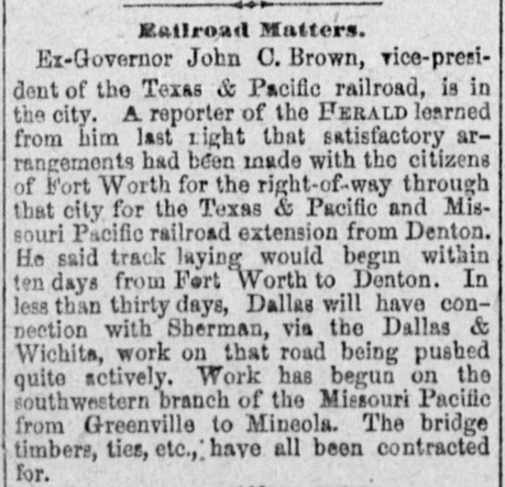
Construction of the T&P line from Sherman to Fort
Worth via Whitesboro and Denton was followed closely in the press.
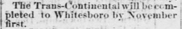
Left, Top:
The Austin Weekly Democratic Statesman
of October 14, 1880 expects the T&P line from Sherman ("the
Trans-Continental") to be complete to Whitesboro in a couple of weeks.
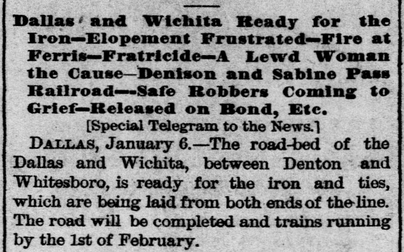
Left Middle: The
Galveston Daily News of
January 7, 1881 asserts that iron and ties will be added to the grade
between Denton and Whitesboro, with trains running in another three
weeks. The article assigns the roadbed to the D&W -- it belonged to the
T&P -- but since the T&P was building the D&W extension from Dallas to
Denton, it is likely that the construction forces simply continued
building north beyond Denton. Construction between Fort Worth and Denton
had not yet begun.
Left, Bottom:
The Dallas Weekly Herald of
January 27, 1881 expects construction northeast from Fort Worth to
Denton to begin shortly. The article describes the work as a "Texas &
Pacific and Missouri Pacific" extension because with the Katy leased to
MP, Gould insisted that MP be credited with all Katy construction.
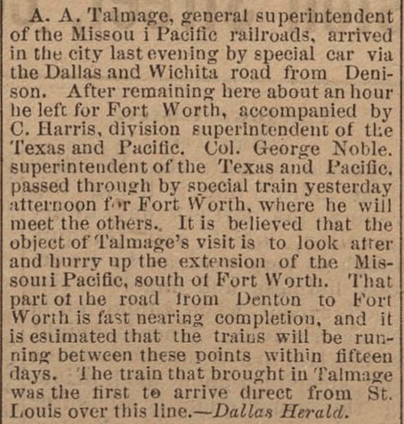
Right, Top: MP's
General Superintendent A. A. Talmage passed through Dallas on his way to
Fort Worth for a railroad meeting. Significantly, his route from St.
Louis went via Denison, Whitesboro and Denton, the first direct St.
Louis - Dallas train via the Katy's Red River bridge. The Denton - Fort
Worth tracks remained in work, hence Talmadge had to route through Dallas and
take the T&P to Fort Worth. (Fort Worth
Daily Democrat, April 10, 1881 quoting the
Dallas Herald.)
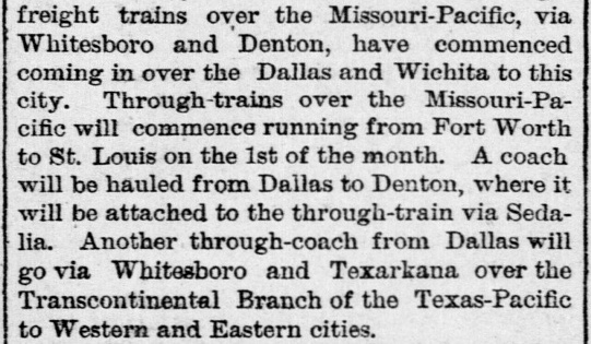
Right Bottom: With the
dateline "Dallas, April 15", the
Galveston Daily News of April 16, 1881 reported that MP
freight trains had begun entering Dallas via Whitesboro and Denton, and
that direct MP Fort Worth - St. Louis service would commence May
1st. The article also reports a planned "through-coach" from Dallas
to Whitesboro, to be added to T&P trains from Fort Worth to Sherman,
Paris and Texarkana. |
|
Right: The
Brenham Daily Banner of May 10, 1881 noted that the Sherman -
Fort Worth tracks were "open for business".
Gould had
initiated the T&P's construction of the Sherman - Fort Worth line in the
summer of 1880 when he had effectively become the T&P's CEO. By the time
it was completed less than a year later, he had been elected T&P
President and he had reached an agreement to take over the I&GN through
a swap of Katy stock. Although this would not occur officially until
June, Gould had already (on May 1) named I&GN General Superintendent
(GS) Herbert M. "Hub" Hoxie to be the GS of the T&P, effectively commanding
both of Gould's two largest Texas railroads. By August, MP (Katy) tracks
had reached Alvarado from Fort Worth but
also from Waco, where MP (Katy) construction forces had been deployed to
build northward. In December, 1881, Gould bridged the Brazos River at
Waco and also finished the I&GN line to Laredo. He connected the MP
(Katy) tracks to the I&GN at Taylor in
April, 1882. Gould was relentless, young (46) and in no mood to waste
time. |
 |
In addition to bridging the Brazos and completing the
I&GN line to Laredo, Gould had another significant event in December, 1881. He
made a deal with Southern Pacific (SP) Chairman C. P.
Huntington that resulted in the T&P sharing SP's track into
El Paso from the west Texas community of Sierra Blanca. This enabled Gould to
release his construction forces in west Texas, saving money and freeing the
T&P's Chief Engineer, General Grenville M. Dodge, to focus on other Gould
projects. Dodge was famous as the
former Chief Engineer for Union Pacific (UP) responsible for the construction
of the eastern part of the Transcontinental Railroad. The news of
Gould's agreement with Huntington must have been welcomed by Dodge, who was running multiple construction projects
simultaneously in the fall of 1881. Besides finishing the T&P into Sierra Blanca,
he was also building the T&P's New Orleans & Pacific line from Shreveport to New Orleans
while completing the I&GN from San Antonio to Laredo.
During periods when T&P construction had been stalled for lack of
financing, Gen. Dodge had spent significant time in Fort Worth evaluating numerous rail projects,
one of which was the aforementioned Fort Worth & Denver City (FW&DC) Railway. It had been chartered on June 6, 1873 with a plan to
build through the Texas Panhandle to meet Colorado & Southern (C&S) rails coming
south from Denver. The Panic of 1873 along with other financial and
organizational obstacles had prevented the start of construction. This made
FW&DC
stockholders very receptive when Dodge offered to build the railroad under the same stock and bond
arrangement Gould had used for the T&P (and likewise, Dodge eventually became
President of the FW&DC.) As this was the FW&DC's initial construction, it did
not yet have tracks into downtown Fort Worth, and obtaining a right-of-way would
be time-consuming and expensive. Instead, Dodge elected to use the Joint
Track as a means for FW&DC trains to reach downtown passenger facilities.
[Presumably Dodge had no difficulty negotiating the agreement to use the Joint Track;
he was still the T&P's Chief Engineer!]
Dodge chose a location on the Joint Track
just over a mile north
of its Trinity River bridge to be the starting point for the FW&DC's construction,
which commenced in
November, 1881. Whether the Hodge name had been applied to this area by then
is undetermined, but the location became known as Hodge Junction. A
little more than a mile north of Hodge Junction, the FW&DC eventually built a freight
yard known as North Yard. Dodge made rapid progress; FW&DC trains
were operating forty miles to Decatur by May, 1882. The initial construction
segment, 110 miles to Wichita Falls, was completed in September, 1882. Several
years later in April, 1888, the FW&DC tracks through the Texas Panhandle
were
complete. A connection with the C&S was accomplished at Texline, Texas and trains began operating
between Denver and Fort Worth.
While the FW&DC was building its main line
in the 1880s, Gould was slowly extending his MP (Katy) main line south and east
from Taylor toward Houston. Intermittent pauses for economic, financial, legal and political
reasons had slowed Gould's progress dramatically after reaching Taylor in 1882.
In 1883, foremost among Gould's many concerns was the threat of competition from
the Texas & St. Louis (T&SL) Railway, better known by the nickname
Cotton Belt. The T&SL had begun as the Tyler Tap Railroad to build
a narrow gauge line from Tyler that would "tap" the T&P main line
twenty miles west of
Longview at
Big Sandy. By 1883 under the new T&SL name, the railroad was operating from
Bird's Point, Missouri on the Mississippi River through Little Rock, Texarkana, Mt. Pleasant, Tyler,
Corsicana, Waco
and
McGregor, terminating at Gatesville.
The
T&SL's rapid expansion
overextended it financially, largely because it lacked the passing sidings and rolling
stock necessary to run a lengthy, single-track railroad efficiently. To its
benefit, it entered receivership in 1884, very likely preventing the T&SL from
falling into Gould's hands. In February, 1886, the St. Louis, Arkansas &
Texas (SLA&T) Railway was created by the bankruptcy judge to become the new
Cotton Belt, going against the advice of T&SL President Sam Fordyce who
believed that unaddressed operational issues would inhibit profitability.
Despite Fordyce's concerns, the receivership ended, Fordyce became President of
the SLA&T, and within a year, he
had decided to build new branch lines into north Texas hoping to compete with
Gould on St. Louis traffic from Sherman and Fort Worth.
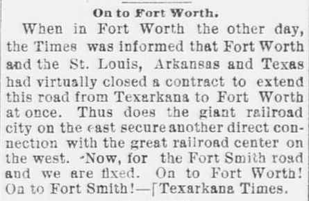
Right: The
Fort Worth Daily Gazette of
June 4, 1887 quoted a recent news item from the
Texarkana Times announcing a
contract to build an extension of the SLA&T west to Fort Worth. The
construction took less than a year.
In 1887, the SLA&T began building a branch line
west from Mt. Pleasant, a town between Texarkana and
Big Sandy on the original T&SL main line that had been built in 1880. At Commerce, 57 miles west of Mt. Pleasant, the
branch split into two branches, one
of which went
to Sherman via Wolfe City and Whitewright (much of the right-of-way is
now Texas Highway 11.) The other branch went to
Greenville and Plano,
passed north of Dallas (where a spur was
later built into downtown), and continued west through
Carrollton. As the SLA&T entered Tarrant County, it
turned southwest toward Fort Worth, crossing the Joint Track
at the future site of Tower 18. A couple of miles farther west, the SLA&T crossed the FW&DC.
A rail yard known as Hodge was built at the crossing, just
under a mile north of Hodge Junction, and immediately south of the
FW&DC's North Yard (but whether North Yard had been built by 1888 is
undetermined.) |
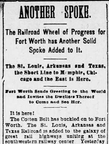
Right:
The Fort Worth Daily Gazette
of
April 3, 1888 reported the arrival of the SLA&T into Fort Worth. The newspaper greeted "the
World" on behalf of Fort Worth, but did any "Dwellers Thereof" accept the invitation to visit? |
 |
Gould knew that the Cotton Belt was on thin ice
financially, so he used this to his advantage by offering Fordyce a secret
arrangement for the Cotton Belt and MP to cooperate on traffic through
Texarkana. Once Fordyce accepted, Gould began to gain financial leverage over
the SLA&T by making loans and purchasing stock, knowing he would be positioned to guide
the Cotton Belt's reorganization when it inevitably became insolvent
as Fordyce had predicted. The receivership occurred in 1889 and a
new company was created by the bankruptcy court in 1891, the St. Louis Southwestern Railway
(usually SSW, sometimes SLSW, but always the Cotton Belt,
which Gould had recommended be the official corporate name.) Gould's late investments in
the SLA&T enabled him to dominate the Cotton Belt's
reorganization. The new company was
headed by Gould's younger son, Edwin, who turned out to be an excellent choice. Edwin
made the Cotton Belt profitable and remained its President until he retired in 1925. Subsequently, a series of ownership
changes resulted in the Cotton Belt becoming a subsidiary of SP in 1932.
 |
Left: Jay Gould visited Fort Worth in April,
1891 to view the stockyards and the Cotton Belt shops at Hodge. (Fort
Worth Gazette, April 11, 1891)
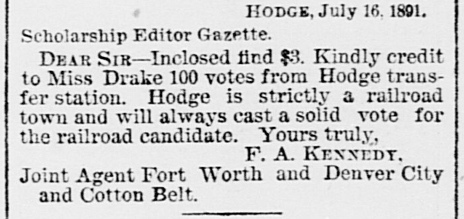
Right: Hodge was never
incorporated, but the residents viewed it as "a railroad town". Note
that a "Joint Agent" served both railroads, apparently sharing a
"transfer station" where the two railroads crossed at Hodge. (Fort Worth
Gazette, July 18, 1891) |
 |
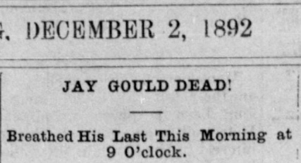
Above:
Texarkana Daily Democrat, December
2, 1892 |
Gould had very little ownership in the Katy leaving him vulnerable
to its stockholders. They were unhappy with the MP lease terms that
drained Katy profits onto MP's bottom line. Gould was fired during a
stockholders' meeting in May, 1888 (a meeting he had worked diligently
to prevent.) The new Katy management
immediately sought bankruptcy protection and requested cancellation of
the MP lease, a request granted by the court, making the Katy independent (and
it stayed that way for the next hundred years!) The Texas
Supreme Court affirmed the order in 1890 and mandated that the Katy remain under court
supervision until the Legislature passed a new Katy railroad charter.
[The Katy had never had a Texas charter; it operated under its Kansas
charter through a law passed by the Texas Legislature in 1870.] The new charter in October, 1891
established a Texas-based Katy subsidiary and required the Katy to divest the I&GN.
That the Katy officially owned it had been a closely held secret that
Gould had revealed when it benefitted on-going I&GN litigation. The
Katy sold the I&GN to Gould for a modest sum
-- no other railroad would bid against him for fear of suffering his
wrath since he controlled the T&P connection at Longview. When Jay Gould died in late
1892, his son George became President of the T&P, the I&GN and
MP. By 1917, the Gould family was no longer involved with those
railroads, but Edwin Gould continued as President of the Cotton Belt
until 1925. Jay Gould's death did not affect the Joint Track with the T&P.
The Katy had always
had the responsibility for a share of maintenance expenses despite Gould's insistence that everything be
publicly credited to MP.
|
The SLA&T's April, 1888 arrival into Hodge occurred
two years after the Gulf, Colorado & Santa Fe (GC&SF) Railway had
laid tracks in the vicinity as part of its agreement to be acquired by the much larger Atchison, Topeka and Santa Fe ("Santa Fe")
Railway. In exchange for favorable acquisition terms, the GC&SF agreed
it would first execute three major construction projects, one of which was to build a line from Fort Worth
to Purcell, Oklahoma to meet tracks Santa Fe was building south
from Kansas. The acquisition was consummated in 1887. Legally, the
GC&SF continued to use its own name as a wholly-owned subsidiary (until 1965),
but since it shared a common term with its parent company, most people just called it
Santa Fe.
Santa Fe's tracks went through the stockyards area a
couple of miles west of
Hodge and they were evaluated as a potential route for the newly-arrived Cotton
Belt to use for access to downtown Fort Worth passenger facilities. The Cotton Belt had
already built west from Hodge to the stockyards to
capitalize on cattle shipping as a potential source
of traffic. The Cotton Belt's other option for downtown access was to use the Joint Track,
just as the FW&DC had done. Presumably, Gould and Fordyce were already having
the discussions that would lead to their secret agreement, so it is unsurprising
that the Cotton Belt chose the Joint Track and the use of T&P's passenger
station.
Having selected the Joint Track route, there were two ways for
the Cotton Belt to
access it: use the FW&DC track between Hodge and Hodge
Junction, or connect to the Joint Track at the crossing east of Hodge, the
future site of Tower 18. Both routes appear to have been used at varying times,
and at least by 1913 (and probably much earlier), a connecting track was in place at Tower 18 to support Cotton Belt access to the Joint Track.
A 1913 SSW
employee timetable (ETT) states: "S.L.S.W trains
occupying track between S.L.S.W. Crossing and T. &. P. Passenger Station at Ft.
Worth will be governed by rules and time table of the M. K. & T. and T. & P.
Joint Track." The Cotton Belt ETT's name for the Tower 18
crossing was the
odd-sounding self-referential "S. L. S. W. Crossing", but it
served to make the Cotton Belt ETT consistent with the terms used by the Joint Track ETT under
which trains operated to reach downtown.
 |
Left:
This snippet of a 1915 Katy track chart (courtesy, Ed Chambers) has been
annotated and re-oriented so that North is up. The track diagram (not
drawn to scale) shows both routes for Cotton Belt passenger trains to
access the Joint Track -- the connection in the southeast quadrant of
Tower 18 and the track between Hodge and
Hodge Junction. The lifespan of the Joint Track connector at
Tower 18 is unknown; it does not
appear on 1946 aerial imagery. The "Ft. W. & D. C." label along the north track west of
Hodge shows that the FW&DC had built its own line into downtown c.1890
by curving through the northwest quadrant at Hodge and turning south at
the stockyards (where Tower 60 opened in 1905.) The
diagram does not show a Cotton Belt /
FW&DC crossing at Hodge. The date the diamond was eliminated is undetermined, but it was likely soon after the FW&DC built its
line into downtown. There would have been no subsequent need
for the FW&DC to cross the Cotton Belt to reach Hodge Junction. The
track between Hodge and Hodge Junction remained intact and appears to
have been used by the Joint Track railroads as a convenient means for
exchanging freight with the FW&DC and Cotton Belt. Note also the
"Ft. W. Belt Ry." label, identifying the Fort Worth Belt (FWB) Railway that
connected to the Joint Track at Belt Junction.

Above: With a reference to "joint track" that was
not the T&P / Katy Joint Track, this
1927 Cotton Belt ETT explains that its trains will share FW&DC and GC&SF
tracks south of "Tower" (Tower 60) to access the GC&SF Passenger Station
downtown. Previously, the T&P Passenger Station had been used, as noted
in the 1913 Cotton Belt ETT. Precisely when the station
change occurred is undetermined, but a good guess would be during the supervision
of the U. S. Railroad Administration which made numerous such changes in
urban areas during World War I. |
Tower 18 was commissioned by RCT on July 25, 1903. The crossing was at an acute angle, and the
tower was located in the obtuse southeast quadrant of the diamond, presumably
between the diamond and the connecting track. RCT's 1903 Annual Report
lists a
12-function / 12-lever Union Switch & Signal mechanical interlocker
at Tower 18. Twelve functions was the minimum standard configuration for a
crossing of two railroads, consisting of a home signal, distant signal and
derail in each of the four directions. RCT documentation shows that the tower
was operated by employees of T&P, suggesting that T&P had taken the project lead
for tower design and construction.
The crossing existed before 1901, so RCT
regulations required the two railroads to split the capital cost of the tower and interlocking plant evenly. In this particular case, the recurring
operations and maintenance (O&M) expenses (e.g. staffing, materials and
utilities) would also have been split evenly
because each railroad used half of the twelve functions. Although the Katy sent
substantial
traffic through Tower 18, RCT did not show it officially obligated for a share of O&M expenses because the Joint Track
was formally owned by the T&P. The T&P's share of Tower 18's recurring expenses would have been
split with the Katy under the trackage rights agreement.
Tower 18's
function count was unchanged from 1903 through 1929, but RCT's
interlocker table dated
December 31, 1930 (the last such table to be published) reported the function count reduced to eight and the interlocking plant converted to automatic. Most likely, the four functions eliminated were
the derails in each direction. Experience across the country had shown
that derails created more problems than
they solved when used as protection for crossing diamonds (though derails
remained valuable for protecting main lines from accidental movements on
industry sidings and spurs.) On March 31, 1930, RCT held a hearing to discuss two automatic
interlockers without derails that the FW&DC had proposed for
Lubbock and
Plainview. The proposal was accepted by RCT on May 1, 1930, hence
Tower 141
(Lubbock) and Tower 142 (Plainview) were the first
towers to get initial commissioning by RCT as
automatic interlockers without derails. They were installed in
February and March, 1931, respectively, and somehow managed to be reported in a table dated December 1, 1930! That same table lists two other
interlockers as automatic: Tower 11 (West Orange) and Tower 18, both of
which had been listed as mechanical in the prior year's table. Tower 11's conversion was completed in June,
1931. The date of Tower 18's conversion has not been determined, but
it's possible that Tower 18 was the
first operational automatic interlocker in Texas.
In 2004, Chuck Harris
shared what he had learned about Tower 18 from working at Hodge:
Glad to help out with the SSW/T&P-MK&T crossing near
Hodge. The place was called Swestern on the Cotton Belt. It wasn't
very far from the SSW yard office at Hodge and the T&P-MKT
yard office at Hodge. The two railroads were about a mile or so
apart and made a gradual slant toward each other before crossing.
You could see the crossing of the two railroads from North Sylvania
Ave grade crossing which was at the east end of the SSW yard.
I would say a mile or so. Yes, there was a tower there, but probably
gone by 1925 or 26. A 1916 dispatcher's train sheet for the SSW
shows a telegraph call for that location which would indicate
it was occupied.
At the end of 1923, RCT's annual report changed
Tower 18's location from "Joint Track" to "North Fort Worth"
which had always been the location listed for Tower 60. While this
change
could
indicate that the Tower 18 controls were
relocated to Tower 60, T&P's 1925 List of Stations reported a
telegraph at "St.LSW
crossing" implying that Tower 18 was still manned. RCT had been known to revise
tower locations, usually to correct a mistake or to clarify a location. This
change -- twenty years after commissioning -- probably
resulted from the lack of specificity in the term "Joint Track" (which was 70 miles long!)
Using "North Fort Worth" had the downside of potential confusion
with Tower 60, thus RCT's interlocker list published December 31, 1927 changed Tower 18's
location to "North Fort Worth (Hodge)".
While the term "Hodge"
might be applicable to a crossing more than two miles from Hodge Yard,
a better explanation is that the interlocker controls were relocated to an office at Hodge Yard.
Remote interlocker control was a technology becoming more widespread in the
1920s, much of it driven by improved train detection circuits that showed the
presence of trains that could not be seen by tower operators (e.g. the
Galveston Island Causeway consolidated three towers in 1927
with train detection circuits covering a span of 5.5 miles.)
Relocating the interlocker controls to Hodge Yard in 1927 would likely have included
installing the interlocking plant in an equipment cabinet at the crossing so the tower building could be removed.
This also fits with Chuck Harris' guess that Tower 18 was "probably gone by
1925 or 26." The ultimate disposition of the Tower
18 structure remains undetermined,
and no photo of it has ever been found.
Chuck refers to the "T&P-MKT yard office at Hodge"
which would indicate that the Joint Track railroads took over the former
FW&DC track segment between Hodge Jct. and Hodge. This probably occurred
in 1891; the track wasn't needed by the FW&DC since
it was no longer using the Joint Track for downtown access. With
both the Cotton Belt and the T&P under Gould's control, it would make
sense to share Hodge yard, an arrangement that continued into Chuck Harris'
time at Hodge. The 1915 track chart
shows connections in both directions at Hodge, but in only one direction
at Hodge Junction.
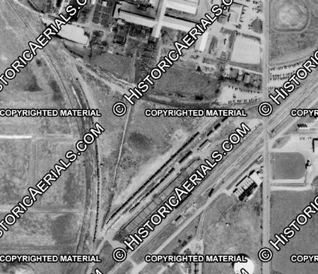
Right: In
this 1952 aerial view of Hodge Junction ((c)historicaerials.com), the
Joint Track slants across the right side of the image at a 45-degree
angle. The original FW&DC switch on the Joint Track is at the bottom of
the image, with the track to Hodge curving up and to the left. Across
the triangle from the switch, a right-of-way is plainly visible, perhaps
with its track still intact. This connector was added at some unknown
date to facilitate Joint Track operations into Hodge. It also gave the Joint Track railroads a wye. Although the
right-of-way (and perhaps the track) for this connector survived
long enough to be visible in this 1952 image, it is only barely
detectable in 1956 imagery and it is no longer present at all in 1963
imagery.
Although Hodge Junction did
not develop an extensive yard, the image shows spur tracks adjacent to
the Joint Track main line. Whether these were used for a general purpose
or a specific business is undetermined. The rail yard a mile north at Hodge evolved and expanded over
the years, adding yard tracks and connectors to facilitate traffic exchange among the Cotton
Belt, the Joint Track railroads and the FW&D. |
 |
After the FW&DC had passed near the stockyards when
building its own line into downtown in 1890, the Chicago, Rock Island & Texas
(CRI&T) became the fourth railroad to pass through the area. The CRI&T was a
Texas-based subsidiary of the Chicago, Rock Island & Pacific (CRI&P,
"Rock Island"), a major Midwest railroad. The CRI&T had crossed
the Red River into Texas near Ringgold in 1892 and continued south, ostensibly
heading to Weatherford on the T&P's main line west of Fort Worth. Having reached
Bridgeport 32 miles shy of Weatherford, the CRI&T amended its charter and turned southeast to build to
Fort Worth. It arrived on August 1, 1893, passing
through Saginaw and the stockyards en route to
downtown.
Another
railroad that operated through Tower 60 at various times was the St. Louis, San
Francisco & Texas, a Texas subsidiary of the St. Louis & San Francisco ("Frisco")
Railway, a major Midwest railroad. B. F. Yoakum had become the Frisco's
General Manager in 1897 after many years of Texas railroading. He was a native Texan who had risen to
the top after executive stints with the San Antonio &
Aransas Pass Railway and the GC&SF. He had started his railroad career
on a track gang for the I&GN. By the early 1900s, Yoakum had become CEO of the
Frisco and had also become the Chairman of the Executive Committee of the Rock
Island Board of Directors, effectively its CEO. As the Frisco and Rock Island
Boards attempted a merger that was never fully consummated, Yoakum sought to expand the Frisco and Rock Island
track networks in Texas. In 1903, Yoakum had Rock Island charter the
Chicago, Rock Island
and Gulf (CRI&G) to build from Fort Worth to Dallas and to absorb the
CRI&T and two other Texas-based subsidiaries. State law required railroads
owning tracks in Texas to be headquartered in state, hence, the CRI&G was based
in Fort Worth and owned all of the Rock Island tracks in Texas.
To compete against Santa Fe for livestock shipments from the vast
range southwest of Fort Worth, the Frisco had purchased controlling interest in the
Fort Worth & Rio Grande
(FW&RG) Railway in 1901. The FW&RG had tracks from Brownwood to Fort Worth, a shorter direct line compared to Santa Fe's route from Brownwood via Temple. The following year, a new Frisco
line entered Texas from Oklahoma. It shared the Katy's bridge over the Red
River, used SP trackage rights to reach Sherman, and then built a new line south to Carrollton.
Yoakum negotiated trackage rights on
the Cotton Belt to allow Frisco trains to reach Fort Worth from Carrollton. The
connecting point in Fort Worth was Frisco Junction, about a half mile
south of Tower 60 where the Cotton Belt intersected a new 4.5-mile track that
led to the Frisco's yard in south Fort Worth.
Frisco Junction was very close to the stockyards, which Frisco served with
industry spurs.
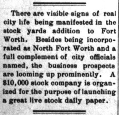 |
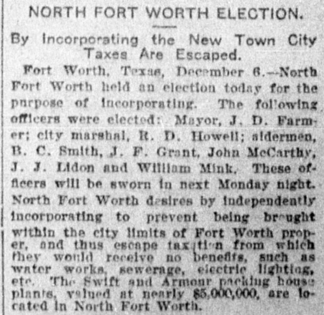
By the turn of the century, the
stockyards had become a massive
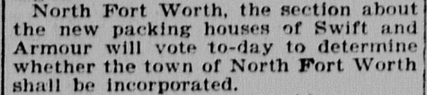
economic engine for Fort Worth. To protect the area from taxation
by the City of Fort Worth, a new town was incorporated as North Fort
Worth in an election held in November, 1902. Reportedly, the vote was
170 - 1.
Left Top:
Dallas Southern Mercury, November
13, 1902
Left Bottom:
Mineral Wells Weekly Index,
November 14, 1902
Right: The new town
held its first municipal election in December, 1902 (Houston
Post, December 7, 1902)
State law allowed larger
cities to annex nearby incorporated areas of limited population. The
1909 Fort Worth City Charter officially abolished North Fort Worth and
took over its debts, but did not immediately incorporate the stockyards. In
February, 1911, a new town, Niles City, incorporated the stockyards
area
with 508 residents. When a January, 1921 state law set a threshold of 2,000 residents
for towns to be able to prevent annexation, Niles City quickly expanded
its boundaries to reach that number. The Legislature responded six
months later by raising the threshold to 5,000 residents, and Niles City
soon met its demise, annexed by Fort Worth on August 1, 1923. |
 |
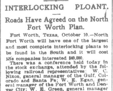
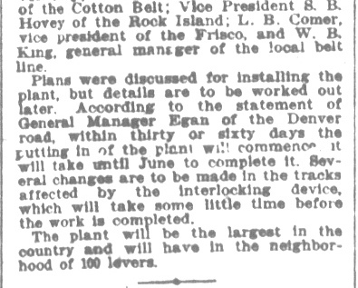
Above Left and Center: Due
to the complexity of the rail junction that had evolved at the stockyards,
developing an interlocker to control it was a substantial challenge. All of the
railroads were involved and they conferred at a meeting in
Fort Worth in October, 1903. A plan was developed but numerous track changes were
required for implementation. While it did "take until June" to complete the
installation of Tower 60, it turned out to be June, 1905, a year later than expected. (Houston Post, October 11,
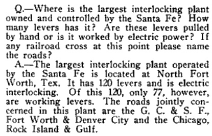
1903) Above Right: This
question appeared in the Q&A column of a 1914 edition of Santa Fe
Magazine. The answer omitted two railroads that were officially
involved with Tower 60: the Cotton Belt and the Fort Worth Belt.
To manage the tangle of connecting tracks and
crossing diamonds near the stockyards, Tower 60 was commissioned by
RCT on July 1, 1905. The tower's location was identified as "North Fort Worth"
and its electrical interlocking plant had 83 functions, a huge number indicative of the complexity of the track
network. Among Texas interlocking plants, Tower 60's function
count was exceeded
only by the 122 functions in effect
at Tower 55 in downtown Fort Worth. Tower 60 would
fall to fourth place by the end of
1930, surpassed by Tower
55, Tower 106 in Dallas and
Tower 26 in Houston. Tower 60 was built by
Santa Fe, which was also responsible for staffing. Santa Fe shared the recurring
O&M expenses with the Cotton Belt, the FW&DC, the Rock Island and the Fort Worth
Belt on a "weighted function"
basis, i.e. the number of interlocking functions allocated to each individual railroad
compared to the total number of functions in the plant. Since all five railroads
had built through the area prior to 1901, RCT regulations required the capital
expense for the tower and its
interlocking plant to be shared equally by all five railroads.

Above: The aforementioned town of Niles City (light pink) had not yet
been devoured by the city of Fort Worth when this map of the vicinity of Tower
60 was published by the Interstate Commerce Commission in its 1918 valuation
report for the FWB. The stockyards had evolved from a cattle shipping
location in the late 1880s to become a cattle processing and meat-packing center
by the mid 1890s. The FWB had its origin in 1895, chartered as the
Fort Worth Stockyards and Belt Railway to provide switching
services for the stockyards and associated processing plants ("Stockyards" was dropped from the name
in 1896.) By 1902, large processing and packing facilities
had been built by Armour and Swift, two national meat companies. The FWB
connected with the Tower 60 railroads and to the Joint Track railroads via Belt
Junction. At Frisco Jct., the Frisco track from its yard in south Fort Worth
intersected the Cotton Belt. Nearby, the Frisco connected with the FWB to access
the stockyards.
Frisco Jct. was the primary means by which Frisco
freight trains arriving from the north on the Cotton Belt continued to the
Frisco's yard in south Fort Worth. Frisco passenger trains approaching Tower 60 on the
Cotton Belt could take the Rock Island line into downtown to access Fort
Worth Union Depot, a station built by Santa Fe that opened in 1900. A T&P
connecting track provided the means for trains to continue west to intersect a
track that led to the Frisco's yard. Access to the Frisco yard from the north
became entirely dependent on this T&P connector when the Frisco dropped its
Cotton Belt trackage rights from Carrollton. Beginning in 1908, Frisco trains
coming into Carrollton from Oklahoma would continue south for eleven miles on a new
connecting track to the Rock Island main line at Irving (built by Yoakum in
1903.) From Irving, Frisco trains could go east to Dallas or west to Fort Worth
where they would curve into downtown to reach the Union Depot and / or the T&P connector to the Frisco yard. RCT's
1908 Annual Report lists Rock Island with 0.36 miles of trackage rights on the
T&P to effect this connection.
In 1937, Frisco sold the FW&RG to Santa Fe, but retained the track between
the Frisco yard and Frisco Jct. so that service to the
stockyards could continue. At some undetermined date c.1954, the T&P connection
downtown that led to Frisco's yard was abandoned, leaving the line from Frisco
Jct. as the only means for trains to reach Frisco's yard. When Frisco freight
trains arrived from Irving, the only choice was to go north to Tower 60 on Rock
Island's main line, but there would have been no way to turn the trains around to
head south to
reach Frisco Jct. To solve this problem, a connecting track from the Rock Island
main line to the Cotton Belt tracks near Frisco Jct. was built barely north of the rail
bridges over the West Fork of the Trinity River. Since Rock Island's track was
the farthest east, the new connector had to cross the other two main lines (FW&D
and Santa Fe) to reach the Cotton Belt. This also required the Frisco to
obtain Cotton Belt rights over a short section of track.
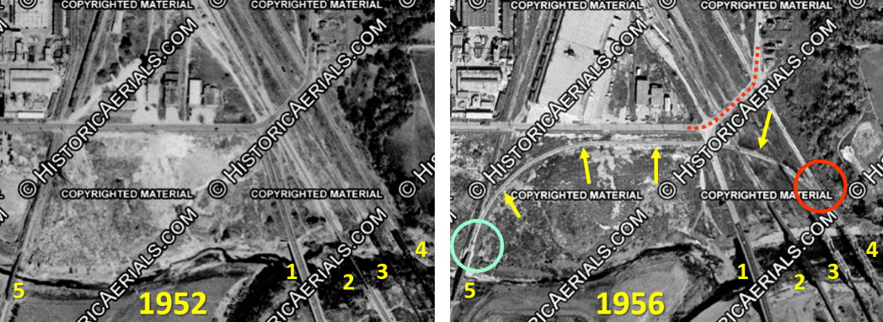
Above: In these two
north-facing aerial images ((c)historicaerials.com), the first four numbered
bridges, all of which cross the West Fork of the Trinity River, are: (1) Samuels
Ave. street bridge; (2) GC&SF rail bridge; (3) FW&D rail bridge; and (4) Rock
Island rail bridge. Bridge (5) is the Cotton Belt rail bridge over Marine Creek.
The rail connector (yellow arrows) that was added between 1952 and 1956 provided
a connection between the Cotton Belt switch (green circle) and the Rock Island
switch (red circle). Frisco Junction was located about 700 ft. south of the Cotton Belt
bridge (5). Due to its proximity, Tower 60 would undoubtedly have managed the
signals and switches for the new connector. The red-dashed roadway is NE
23rd St. / Decatur Ave. which crossed the three main tracks at grade.
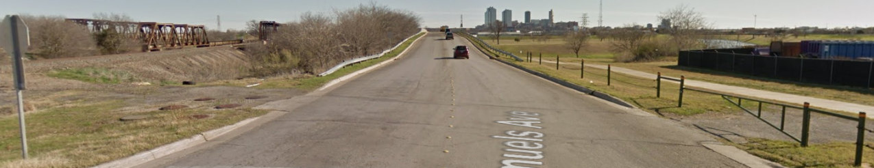
Below: Looking south, lines in the Samuels Ave. pavement mark its grade
crossing of the former Frisco connecting track which was removed sometime between
1981 and 1990.
The switch off the Cotton Belt remains intact, but the track now ends inside the
fenced yard of the unidentified business to the right. (Google Street View 2013)
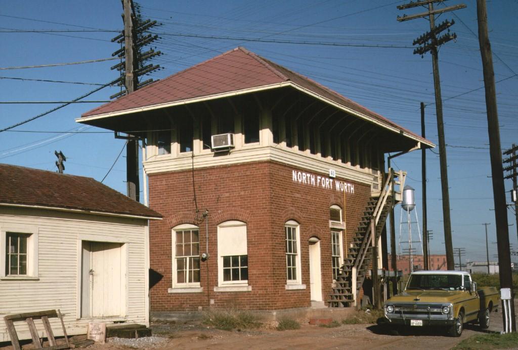
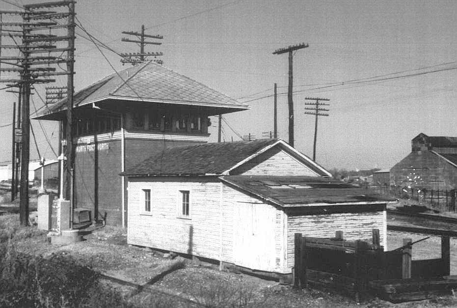
Below: Tower
60 was razed c.1987 (undated photo, Museum of the American
Railroad collection)
 |
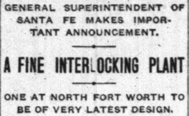
Fort Worth Record & Register,
February 8, 1904
Who wouldn't want to see a "monster interlocking plant"?
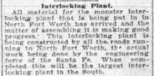
Fort Worth Record & Register,
September 2, 1904 |
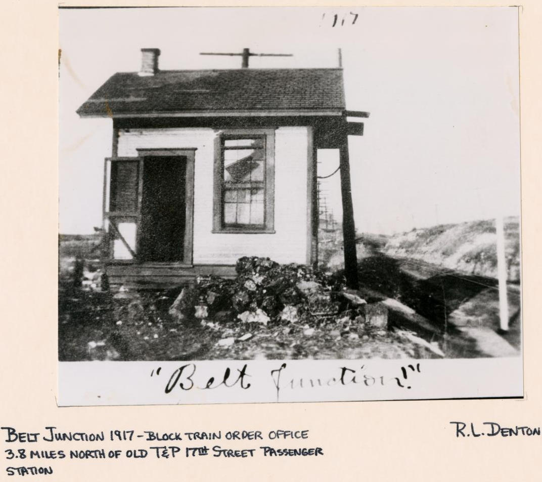 |
Left:
A train order office, presumably operated by the Fort Worth Belt, was
located at Belt Junction. (1917 photograph by R. L. Denton, courtesy the Grace
Museum, Cleburne, hat tip, Dennis Hogan)
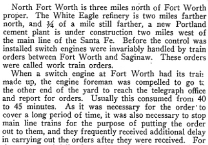
Right: These passages are excerpted from the June
6, 1925 issue of
Railway Review which published a
paper presented in March of that year by Santa Fe Signal Engineer, E. Hanson, at a Chicago gathering of the Signal Section of the American
Railway Association. The paper was titled Train Operation By Signal
Indication Only, describing a comprehensive control system that had
been installed
by Santa Fe between downtown Fort Worth and Saginaw, a distance of eight
miles. The control system allowed switch engines to operate without
train orders and was managed primarily by operators at Tower 60, near
the midpoint of the system. The paper notes "...an average of 1,000
train and engine movements per day..." through the Tower 60
interlocking. Wow! |
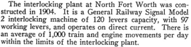 |
Above: In this southeast-facing snippet from an undated
(c.1945) aerial image of the meat-packing plants near the stockyards, Tower 60
is highlighted left of center. This appears to be the brick tower that survived
to the late 1980s. No direct evidence has been found to suggest that a tower preceded the brick structure
of later years. At upper right, the image shows the four bridges (Samuels Ave. plus the three rail lines) over
the West Fork of the Trinity River, with the NE 23rd St. / Decatur Ave. roadway
crossing all three tracks at grade. The
Rock Island - Cotton Belt connector for the
Frisco is absent; it did not yet exist. (image courtesy Bennett.Partners)
As the railroad industry consolidated, the track
ownership through Towers 18 and 60 changed. The end result was two dominant
railroads: Union Pacific (UP) and Burlington Northern Santa
Fe (BNSF.) On the UP side, majority ownership of the Fort Worth Belt
(FWB) was obtained by the T&P in 1932, but the FWB continued to operate
under its own name. In the 1970s, the FWB and T&P were merged into MP, which had
owned a majority share of T&P stock since the 1930s but had never exercised control. MP
was acquired by UP in 1982 but continued to operate under the MP name. In March,
1980, Rock Island went into bankruptcy and ceased operations. In June, its main
line into Fort Worth was acquired by the Oklahoma, Kansas & Texas (OKT)
Railroad, a new subsidiary of the Katy. UP acquired and merged the Katy into
MP in 1988, bringing with it the OKT (and reuniting the Katy with MP a hundred
years after Texas courts had abrogated MP's lease.) In 1996, UP acquired SP which had owned
the Cotton Belt since 1932. In 1997, MP and SP were integrated operationally under the UP name.
In 1965, the GC&SF was merged into the parent AT&SF. In 1980, the Frisco was
merged into Burlington Northern (BN.) A year later, C&S was merged into BN, taking with
it the FW&D. C&S had been part of the Burlington system since 1908. AT&SF and BN merged to become
BNSF in 1996.
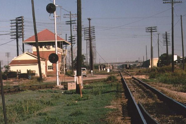
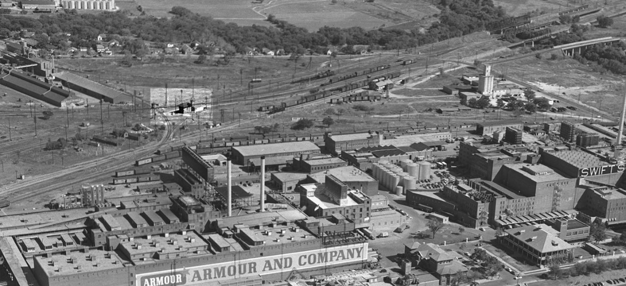
Above Left: This view is looking northwest along the
Rock Island tracks passing beside the east face of Tower 60. The FW&D crossing
is in the foreground and the FWB can be seen behind the tower. Above Right:
This southwest view down the Cotton Belt shows southbound Santa Fe locomotives
about to pass the west side of the tower. The near diamond is the Rock Island
crossing of the Cotton Belt, and the FWB crosses the Cotton Belt just beyond it.
(both photos by Gary Morris, October, 1976)
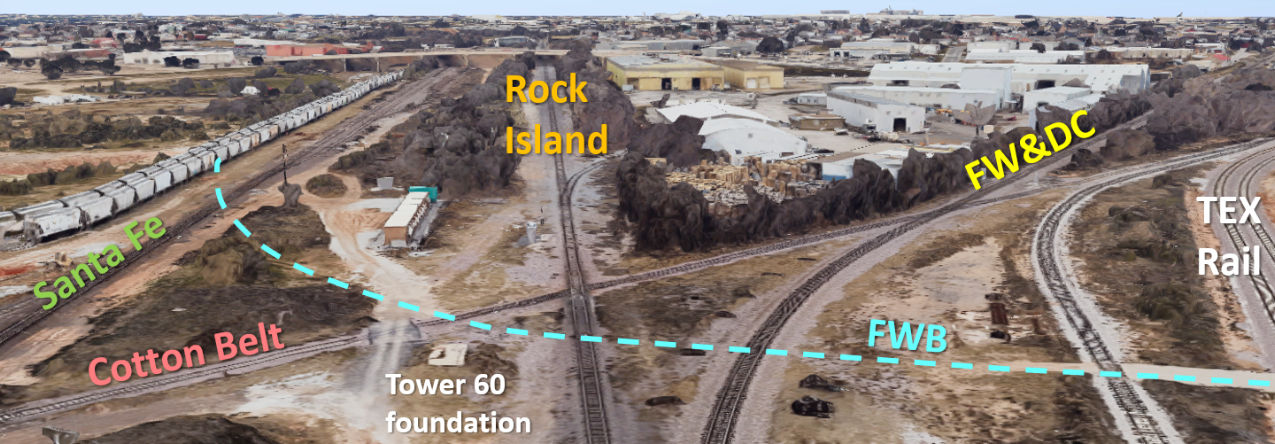
These recent Google Maps'
simulated 3-D images of the Tower 60 junction have annotations showing the legacy
railroads.
Above: This view is northwest along
UP's former Rock Island right-of-way. Historic aerial images indicate that the "road" visible to
the left of the tower's foundation was originally a spur or connecting track. Aerial imagery shows that the FWB tracks were removed at
some undetermined time between 1981 and 2001.
Below: This image shows a southwest view along the former Cotton Belt tracks.

The original track segment between Hodge Junction and Hodge remains in place with a few spurs into various trackside businesses.
It is owned and operated by
the Fort Worth & Western (FWW) Railroad, a Class III short-line railroad founded
in 1988 that also operates the yard at Hodge. Among various expansions, the FWW took
over operation of the former Cotton Belt line between Carrollton and Fort Worth.
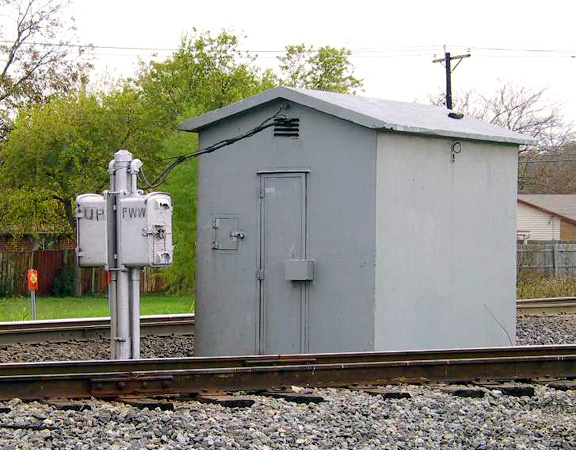
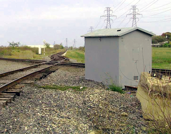
Above: In these photos taken c.2002, a walk-in hut
located within the acute angle southwest of the diamond houses the automatic interlocker
at the Tower 18 crossing. The post in
front of the door holds manual override controls for UP and FWW to allow train
crews to override the signals when necessary. The odd curves on the FWW's former Cotton Belt track near the diamond resulted from the use of a
replacement crossing diamond that did not have the proper angle. This was
subsequently corrected. (Jim King photos.)
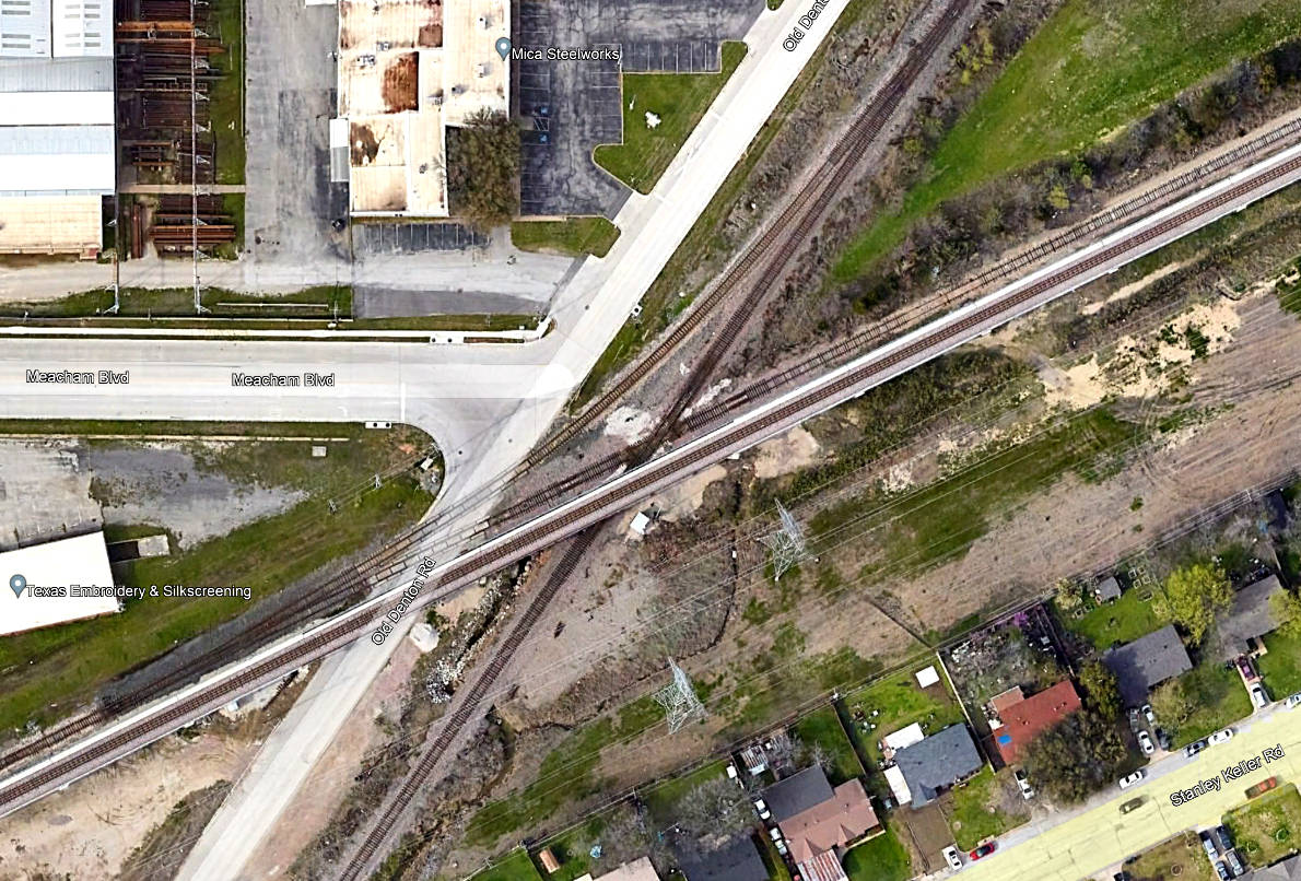
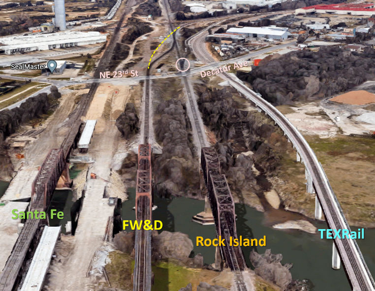
Above: This 2022 Google Earth image of the Tower 18
crossing shows a connecting track in the northwest quadrant. It also shows a
TEXRail bridge passing over Old Denton Rd. and the former Joint Track (now UP.)
TEXRail is a commuter rail system between downtown Fort Worth and DFW airport
that shares portions of the former Cotton Belt right-of-way. The FWW freight
tracks are visible parallel to the bridge, still crossing the former Joint Track at grade. Just over a
mile to the east, the commuter and freight tracks merge into a single
ground-level track. Proceeding east to Grapevine and DFW Airport, they
periodically re-divide into separate commuter and freight tracks in the vicinity
of passenger stations. To the west, the commuter tracks remain isolated all the
way into downtown, and much of the right-of-way is grade-separated.
Kal Silverberg explains the
connecting track... (Sept. 22, 2004)
"Tower 18 now has a connection in place in the northwest quadrant so southbound
trains on the former T&P can go west on the former SSW through Hodge Yard. There
is a new track along the north side of Hodge Yard and it has CTC signals at the
east end of Hodge Yard (by Sylvania St. crossing) waiting to be turned on. The
new track ties into the former FW&D line just east of Deen Road. It is my
understanding that UP will run directionally between Towers 18 and 55."
...and the commuter rail
bridge (June 4, 2020)
"TEXRail to DFW Airport from the T&P station in downtown Fort Worth began
operations in January, 2019. Construction probably started in 2017 so that's
when the bridge over Tower 18 went in. TEXRail is completely separated from the
railroad network from north of Tower 18 to the former 6th Street Jct. in Fort
Worth, with the exception of one crossover at the north (east) end of Hodge Yard
to enable equipment to get to and from the TEXRail maintenance base."
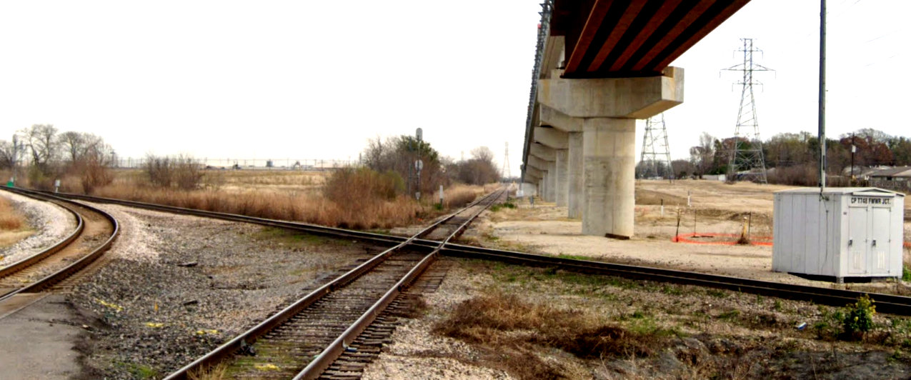
Above:
Facing east-northeast along the former Cotton Belt tracks, this February
2019 Google Street View shows the Tower 18 crossing site. The former
Joint Track, now a UP main line, crosses in the foreground, and UP's 2004 connector track in the northwest quadrant is
visible at far left. The UP equipment cabinet at right is labeled with a Control
Point number and "FWWR Jct."
Overhead, the TEXRail bridge provides grade separation for commuter rail trains
to / from DFW airport. The freight rails and the commuter rails join into a single
ground-level track just over a mile distant, but they periodically separate at
commuter stations as the line proceeds to DFW Airport.
Below:
This simulated Google Maps 3-D view of Hodge Yard shows how the Cotton Belt would
have crossed the FW&DC main line
from Hodge Jct. prior to the FW&DC's construction of a separate line into downtown (curved line
at far left). Now, the
track coming up from Hodge Jct. splits into east and west connector tracks, the
west track showing a pair of UP locomotives. The blue arrows mark the elevated
line for TEXRail commuter trains which returns to ground level to pass beneath
Interstate 35W.

 |
Left:
Looking north toward the former Tower 60 area, this 2023 Google Maps simulated 3-D image
shows that the traditional "Three Sisters" rail bridges over the West Fork of the Trinity River
have been joined by a fourth at far right carrying TEXRail commuter trains.
Major construction for a second "Santa Fe" bridge is underway as BNSF double-tracks the route from Saginaw into downtown Fort
Worth. The bridge work was completed in the summer of 2025 and included
removing the truss and rehabilitating the original bridge. Where the FW&D
(BNSF) previously curved northeast (yellow dashes) to cross the Rock Island
(UP), the diamond has been removed, replaced by a switch onto the UP track
leading immediately to a second switch onto the former FW&D line to
North Yard (which then crosses the former Cotton Belt tracks.) A switch (pink circle) off the Rock Island just
beyond the Decatur Ave. grade crossing leads to the former Cotton Belt
(FWW) tracks
which proceed northeast into Hodge.
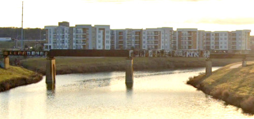
Above: The former
Joint Track (now UP) bridge over the West Fork of the Trinity River is
0.6 miles east of the "Three Sisters".
(Google Street View, January, 2023) |