Texas Railroad History - Tower 183 - Tyler
A Remote Control System for Lufkin Junction

Jody Garner took these photos c.2005 at the
Tower 183 crossing in Tyler showing what might have been the last operational
railroad gate in Texas (removed shortly thereafter.) This was one of the early
rail grade crossings in Texas, dating to the latter 1870s. At the time, it was a crossing of
the Tyler Tap Railroad and the International &
Great Northern (I&GN) Railroad. The Tyler Tap eventually morphed into the
St. Louis Southwestern (SSW, "Cotton Belt") Railway, and in 1925, the I&GN became
part of Missouri Pacific (MP.) By the mid 1990s, both rail lines were owned by
Union Pacific. Above Left:
This view is to the north showing the gate positioned against the former I&GN
tracks toward Lindale. The brick columns at left are for a perimeter fence at the Cotton Belt depot
which had recently been renovated. An abandoned equipment cabinet sits in the
distance at right. Another cabinet near the crossing might have been
in use. Above Right: This view
looks east along the former Cotton Belt line
toward Big Sandy, with the North Beckham overpass
visible in the distance. The former Cotton Belt passenger platform laid with
bricks is
in the foreground, and columns for the depot's perimeter fence are to the right.
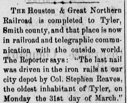
While the Houston
& Great Northern (H&GN) Railroad was building its main line from
Houston to
Palestine in 1872, the International Railroad reached Palestine as it built between Longview and
Hearne. The two railroads agreed to merge
under the name the International & Great Northern (I&GN) Railroad.
The I&GN would need a railroad charter from the Legislature, so while waiting
for the bill to pass, the two companies adopted a combined management team at a
Houston headquarters in December, 1872 to operate both railroads
as a single enterprise.
Above:
Dallas Daily Herald, April 4, 1873 |
The management team at Houston kept building
while waiting for the new charter. A branch to Mineola
via Tyler built
by the H&GN in 1873 departed the International's main line at
Troup, southwest of Longview, the closest point to Tyler.
Construction by the International southwest from Hearne continued, but
stopped at Rockdale in January, 1874.
The
delay in the Legislature's approval of the I&GN charter was due to a major issue over the
International's claim for construction subsidy bonds to be issued by the
State. Citing unspecified corruption, the Texas Comptroller had refused
to countersign and register the bonds despite the State engineer's
report that the work covered by the bonds was of high quality and met
the requirements of the International's charter. As legal proceedings
moved slowly, a lengthy debate raged statewide. Much ink was spilled as
to whether the bond issuance was in accordance with state law, or
instead constituted a demand by the International for an
unconstitutional subsidy. A compromise was eventually found, and the
charter bill passed in 1875. Construction out of Rockdale toward
Austin resumed a year later.
|

Above:
Galveston Daily News, March 26,
1875 |
The H&GN branch to Tyler and Mineola was the initial
step in
reaching Denison where the Missouri, Kansas &
Texas (MK&T, "Katy") Railway had opened a new bridge over the
Red River. Export commodities from the Plains and Midwest states had
begun to move south to
Houston and
Galveston through
an interchange with the Houston & Texas Central (H&TC) Railway
at Denison. The I&GN wanted to gain a share of this traffic by offering
an alternate route from Denison to Houston via Troup and Palestine.
Prior to the H&GN construction, citizens of Tyler had recognized that
their town was likely to be bypassed by the major railroads under construction: the International was 18 miles south and the Texas & Pacific
(T&P) Railway was 18 miles north.
This led to the chartering of the Tyler Tap Railroad in 1871 to connect
with either the T&P or the International. No work was undertaken until after the
H&GN had arrived at Tyler in 1873, influencing the Tyler Tap's decision to lay tracks to Big Sandy to connect with the T&P.
This was accomplished in 1877, but unfortunately, as a narrow gauge railroad, the
Tyler Tap could not interchange cars with the T&P. Instead, trans-loading was
accomplished over a parallel siding.
In 1879, new investors came into the ownership group of the Tyler Tap and
modified its charter with expansive plans. Among the changes, the railroad was
renamed the Texas
& St. Louis (T&SL) Railway. In 1880, converting to standard gauge,
the T&SL extended the existing tracks southeast from Tyler to Athens
and
northeast from Big Sandy to
Texarkana, with plans to continue across Arkansas
toward St. Louis.
Right: The T&SL's first ad in the statewide
newspaper of record, the Galveston Daily
News, ran in the issue of January 21, 1881. It is
historically significant because it shows the T&SL claiming the moniker
"Cotton Belt Route". While "cotton belt" was a common geographic and
geopolitical term for various cotton-producing areas in the South, this
is the first known instance of the T&SL using "Cotton Belt Route" as a
marketing slogan for the railroad. The public embraced it; "Cotton Belt"
would be the nickname of an operational railroad for the next 110 years.
|
 |
Rail baron Jay Gould had been alarmed by the 1872 announcement of the
merger creating the I&GN. Gould had been planning to expand his east coast and
Midwest rail empire into Texas, but the I&GN would be a formidable competitor.
It already served Houston and Galveston, and it had
legitimate plans to reach Austin, San Antonio and
Laredo; Gould had no rails in Texas at all. The T&P provided the I&GN with a
friendly connection between Longview and Texarkana from which other railroads
facilitated direct access to St. Louis, territory controlled by Gould. Gould plotted a
lengthy effort to gain control of the I&GN beginning with a takeover of the Katy
to be his initial rail presence in
Texas.
Gould could not buy his way into control of the Katy; its stock was much
too diluted and there were no large blocks for private sale. Instead, his
takeover plan involved infiltrating Katy management with his loyalists led by
William Bond, the Katy's Second Vice President. Bond orchestrated Gould's
election as President of
the Katy in December, 1879, giving Gould control of the Red River bridge at
Denison, an important element of his plan to gain leverage over the I&GN. With little Katy stock ownership, Gould could best reap the
benefits of the Katy's profitability by leasing it to a railroad he controlled,
the Missouri Pacific (MP) Railroad based in St. Louis in which he had a
large ownership position; this occurred in December, 1880. As a result of lease accounting and operating policies
tilted heavily toward MP, its stockholders (particularly Gould) would enjoy the
profits of the combined enterprise while Katy stockholders would see their
company simply remain afloat -- not losing money but not profitable.
To
execute his plan for capturing the I&GN, Gould also needed to control the T&P.
Its construction had stalled at Fort Worth, so he
made a deal with T&P management to build their line from Fort Worth to
El Paso at his expense, with his equity
accruing incrementally with each mile completed. When
his ownership passed 50% in April, 1881, Gould became T&P President, gaining
control over the I&GN's access to Texarkana. Since
he also controlled the Katy's Red River bridge, he effectively had boxed-in
the I&GN, impacting its traffic to and from the Midwest. I&GN management
recognized their predicament and sold out to Gould two months later in a swap for Katy stock. Gould became
President of the I&GN and leased it to the Katy for 99 years, allowing the
I&GN to continue using its own name (a recognized brand, the largest railroad in
Texas at the time.) In December, 1881, the I&GN reached the Mexican border at
Laredo, with Gould in control.
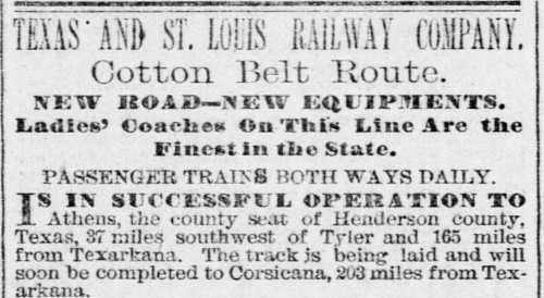
In direct competition to MP, the T&SL had expanded
rapidly, extending its main line southwest from Athens to
Corsicana and Waco in
1881. By 1883, the T&SL was operating between Bird's Point, Missouri on
the Mississippi River, and Gatesville, Texas, via Texarkana, Tyler and
Waco. This expansion overextended the T&SL, causing it to enter
receivership in 1884, though the bankruptcy undoubtedly helped keep it from
falling into Gould's hands.
In February, 1886, the St. Louis, Arkansas &
Texas (SLA&T) Railway was created by the bankruptcy judge to become the new
Cotton Belt, going against the advice of T&SL President Sam
Fordyce who believed there were unsolved operational issues that would inhibit profitability.
Within a year, the SLA&T had decided to build new branch lines into
north Texas from its main line at Mt. Pleasant to compete with Gould on
traffic from
Sherman and Fort Worth. Gould knew that the
Cotton Belt was on thin ice financially, so he used this to his
advantage by offering Fordyce a secret arrangement for the Cotton Belt and MP to cooperate on traffic
through Texarkana. Once Fordyce accepted, Gould began to gain financial leverage over the SLA&T with
loans and stock purchases. This positioned him to guide the Cotton Belt's reorganization when it
became insolvent, as Fordyce had predicted, in 1889.
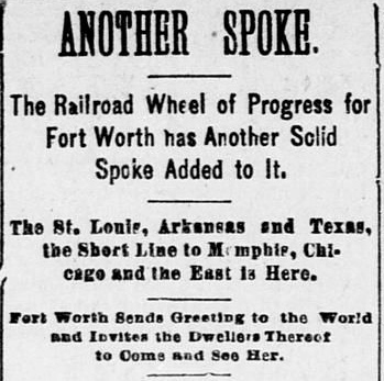
Right: The Fort Worth Daily Gazette of
April 3, 1888 welcomed the arrival of the Cotton Belt tracks to Fort
Worth in its typical, over-the-top fashion. Perhaps the Cotton Belt had
a special fare to Fort Worth for World Dwellers. |
 |
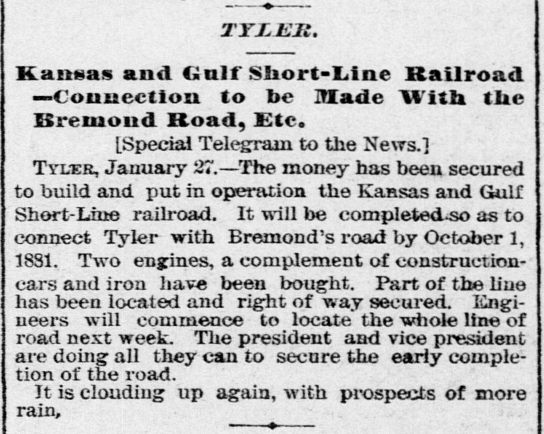 |
In 1880, the newly chartered Kansas & Gulf (K&G) Short Line Railroad
proposed to build between Tyler and Sabine Pass to provide a Gulf of Mexico port
for east Texas timber products. The company began by acquiring the assets of the
defunct Rusk Transportation Co. (RTC) which had built a 17-mile wooden-rail tram
between Jacksonville and Rusk in 1875. RTC's charter had been modified to extend
its wooden rails north to Tyler and south to Sabine Pass, hence the K&G merely planned to implement,
albeit with narrow gauge iron rails, what the RTC had
started.
Left:
The Galveston Daily News of
January 28, 1881 reported that the financing of the K&G had been
secured. The plan to connect to "Bremond's road" was a reference to the
Houston East & West Texas (HE&WT) Railway that was under construction at
the time by Texas rail pioneer Paul Bremond. It was a narrow gauge line
through east Texas between Houston and Shreveport. The K&G planned to
connect at Lufkin, which the HE&WT expected
to reach in 1882.
The K&G built 29 miles from Tyler to
Jacksonville in 1882. Another 43 miles was built
south to Lufkin in 1885, partly using the RTC right-of-way. The K&G was sold to the SLA&T in 1887 but remained a
separate entity. When the SLA&T went into receivership in 1889, the K&G did
also.
The SLA&T bankruptcy ended on January 12, 1891 with
creation of the St. Louis Southwestern (SSW) Railway (still the Cotton Belt.)
A new, independent
Tyler Southeastern Railway was chartered to replace the K&G. The Tyler
- Lufkin tracks were converted to standard gauge in 1895, and four years
later, the Cotton Belt bought the Tyler Southeastern. |
To no surprise, the creation of the SSW in 1891 was dominated
by Gould, who installed his younger son
Edwin as President (and Edwin held that title until his retirement in
1925.) A series of ownership changes in the late 1920s resulted in the Cotton
Belt becoming a subsidiary of Southern Pacific (SP) in 1932, but still
operated under the SSW corporate name. It was still mostly called the Cotton Belt,
and that moniker would
finally be retired operationally in 1992 when it became fully merged into SP.
 |
In April,
1888, Katy stockholders were able to summon a quorum and fire Gould for
malfeasance. New Katy management immediately sought bankruptcy protection. At
the time, Gould was already engaged with legal problems stemming from lawsuits
filed months earlier by the Texas Attorney General against the Katy and the
I&GN. Katy management asked the bankruptcy court to void the lease to MP, and
they eventually succeeded under a ruling by the Texas Supreme Court. When all
the legal dust settled by the end of 1891, Gould was able to remain President of
both the T&P and the I&GN (and MP) while the Katy returned to being an
independent railroad. Gould died in December, 1892, and his son George took
over. The Gould family's involvement with MP, the T&P and the I&GN would last
another twenty-five years.
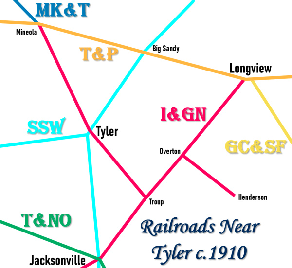
Left:
Railroads Near Tyler c.1910
After the Cotton Belt's
acquisition of the Tyler Southeastern line that went south to Lufkin,
the only two railroads at Tyler were the SSW and the I&GN. In
addition to the aforementioned T&P and MK&T railroads, there were two
other major railroads with tracks in the vicinity of Tyler:
Texas & New Orleans (T&NO) Railroad -- The T&NO was a
subsidiary of SP that became the primary operating railroad for SP lines
in Texas and Louisiana. SP subsidiaries were leased to the T&NO in 1927
and fully merged in 1934. SP acquired the SSW in 1932 but chose not to
merge it into the T&NO. The T&NO line through
Jacksonville was built in 1902 as part of an agreement with the
State of Texas to complete a line between
Dallas and Beaumont.
Gulf,
Colorado & Santa Fe (GC&SF) Railway -- The GC&SF line into Longview
resulted from several east Texas railroads being pieced together by
Santa Fe to form a complete line from Beaumont. The
final segment was 21 miles built between Center and Gary in 1906 that
crossed the HE&WT northeast of Lufkin at Tenaha. |
The I&GN went into bankruptcy in 1908 and
again in 1914. Finally independent of the Gould family, it emerged in 1922 as a
new corporation (the International - Great Northern, "I-GN") and
immediately became a target for acquisition because of its vast track network in
Texas. MP tried to buy it in 1924 but the sale was nixed by the Interstate
Commerce Commission (ICC.) The ICC had jurisdiction instead of the Railroad
Commission of Texas (RCT) because the Federal Transportation Act of 1920 had
expanded the ICC's powers over interstate railroads. Not to be deterred, MP
executed its fallback strategy by helping to arrange for the New Orleans,
Texas & Mexico (NOT&M) Railway to buy the I-GN, simply to keep it
out of the hands of competitors. The NOT&M was a collection of railroads that
operated between New Orleans and Brownsville under the marketing name Gulf
Coast Lines (GCL.) The sale was approved by the ICC in June, 1924, and the
ICC then allowed MP to buy the NOT&M on January 1, 1925, acquiring the I-GN and
all of the GCL railroads. MP suddenly went from having no rail mileage in Texas to
having the most.
With a table dated December 31, 1902, RCT began
publishing a comprehensive list of active interlockers in Texas along
with associated details, e.g. the tower number, the location, the
railroads involved, and the
interlocking plant's function count. RCT's effort to introduce interlocker technology
into Texas was pursuant to its authority to regulate safety aspects of
railroad grade crossings granted under a state law passed in 1901.
RCT continued producing an annual interlocker list until a final table
dated December 31, 1930 was published. The last entry in that final
table was Tower 170 at Conroe ... but RCT
did not stop numbering new interlockers (though there weren't as many as
in the early years.) RCT would
sometimes mention new interlockers in its annual reports, but it never
produced a complete list of the numbers above #170 that had
been assigned.
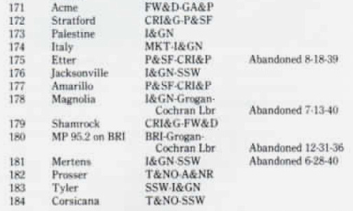
In 1986-87, William J. Neill researched the
interlockers commissioned by RCT beyond 170. The results were published in
The Cross Tie, a magazine (of which
Neill was Editor) published for employees of SP's San Antonio Division. He
determined that RCT had continued issuing new towers numbers through
Tower 215 in 1966. This excerpt (right)
from The Cross Tie #17 shows Neill's list of
Towers 171 through 184, including Tower 183 at Tyler. The original research that
Neill conducted to associate Tower 183 with Tyler is undetermined, but
so far, no evidence has been found to support the claim that Tower 183
controlled the SSW / I-GN crossing, or that there was any kind of safety
system at that crossing that would have been commissioned by RCT. It
seems to have had an unremarkable swing gate, nothing more. |
 |
Jody Garner in a 2008 email wrote "... All I ever saw at the crossing was a gate and this is dating back to the
mid-50's. However, the gate is no longer there, having been removed a couple of
years ago. At one time a very substantial amount of interline traffic came off
of the Cotton Belt, particularly Arkansas rice which was routed to Freeport. In
the 1950's, a lot of butane in Warren tank cars came from somewhere on the
Cotton Belt. There was a switch engine stationed in Tyler until about 1990."
 |
Independent SP documentation obtained by Carl Codney
gives commissioning dates for Towers 182
and 184 as April, 1936 and December, 1937,
respectively. Thus, Tower 183's planning should have supported a
commissioning date in that timeframe, though it might have drifted into
1938. Other than gates (which are neither numbered nor commissioned by RCT)
no references to any control system for the Tyler crossing have been
found in Employee Timetables (ETTs) issued by SSW or MP.
Left:
A 1940 Special Instructions bulletin issued by the Cotton Belt reported
the MP crossing at Tyler as "protected by crossing gate."
If Tower 183 provided some kind of protection for this crossing in the
1938 timeframe -- even signals controlled electronically by a gate latch
-- shouldn't it have been mentioned in a 1940 SSW ETT? |
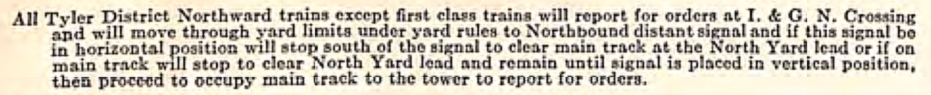 |
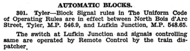
Left: This
excerpt from a 1920 Cotton Belt ETT indicates some kind of train order
office at "I. & G. N. Crossing.", presumably a yard
office, or inside the Cotton Belt depot.
If there was a "tower" there, it was unknown to RCT. |
A 1950 Cotton Belt Special Instructions bulletin
reproduces the same paragraph as the 1940 bulletin regarding the gate at Tyler.
Although a 1920 Cotton Belt ETT (above) refers to occupying "main track to the tower
to report for orders" there is no indication that this was an
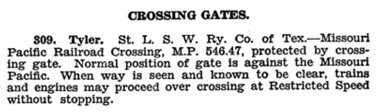
interlocking tower, more likely a yard tower or dispatcher's office, possibly
inside the depot (which was at the crossing.) That same ETT does not list the
I&GN / SSW diamond among the crossings noted as interlocked. MP ETTs from 1961 and 1971 also list only a gate, and as the photos
at top of page show, the gate was still intact in 2005. At least through that
timeframe, the railroads never even bothered to install an automatic
interlocker. Most likely, the presence of yard tracks and the nearby depot meant
that all Cotton Belt trains were operating slowly enough anyway to account for
the gate position visually. "When way is seen and known to be clear, trains
and engines may proceed over crossing at Restricted Speed without stopping."
The Cotton Belt didn't need an interlocker or anything else; the gate was
satisfactory for their operations and for MP's, which had less traffic across the diamond.
Editor's Note:
The RCT interlocker archives at DeGolyer Library, Southern Methodist University,
should be able to answer the question of the nature and location of Tower 183.
But from several visits to DeGolyer in 2007, the notes I took have no references
to it. I was collecting as much information on all of the towers as possible and
it's possible that I simply overlooked it, although I have notes on many other
towers in the same numerical range. The file folders were in numerical order,
but in some cases, the folder for a particular tower was empty or
not present.
Bill Neill must have found some
evidence to indicate that Tower 183
was at Tyler. Having done so, he may not have conducted additional research to
determine where in Tyler it was located; the SSW / I&GN crossing was
the only one in town. No objective documentation from RCT or any railroad has
been found to reference Tower 183 or any kind of safety system at the I-GN / SSW
diamond that might have been numbered by RCT. So far, all Internet search
results for Tower 183 ultimately trace back to the information provided in The Crosstie #17. If Tower 183 wasn't
at the SSW / I-GN crossing, what else might account for RCT's assignment of interlocker
#183, assuming that it was in
Tyler?
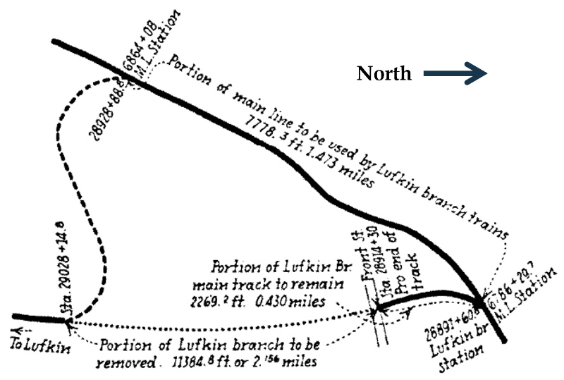
In 1938, the Cotton Belt began a project to
relocate its Lufkin Branch connection. The branch switched off of the
SSW main line six-tenths of a mile west of the I-GN crossing. The tracks
had been located in rural farm land when laid in 1882, but fifty years
later, the area was valuable residential real estate despite the
presence of the rail line.
Neighborhoods with expensive homes had evolved, creating new streets
and a dozen grade crossings of the Lufkin Branch, two of which were
high-traffic state highways. Grade separation was determined to be
infeasible, so the City and the railroad opted to relocate the tracks. The
Lufkin Branch switch on the SSW main line was moved 1.5 miles farther west and a new track 1.8 miles long was
built from there to connect to the Lufkin Branch about two miles
south of the original switch. Those two miles of original Lufkin Branch
right-of-way (ROW) were abandoned, and the land was repurposed by the City to benefit the neighborhoods.
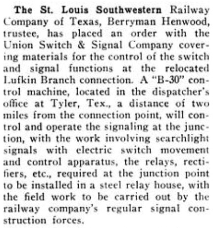
Right: A news item in
the December, 1938 issue of Railway
Signaling reported the Cotton Belt's acquisition of a B-30 miniature-lever desktop control panel
built by Union Switch & Signal Co. The B-30 was to be used to
control "...the switch and signal functions at the relocated Lufkin
Branch connection." B-30s were commonly used to control
signaling and interlocking systems.
By 1928, RCT had established that it was very protective of its authority to approve
all interlocking devices, even those
that were used by a single railroad for its own purposes with no other
railroad involved. The test case was RCT's assertion that it had the
authority to review and approve the interlocking plants employed by the
Panhandle & Santa Fe Railway to arbitrate the transition on and off the
double-track segment Santa Fe had built between
Canyon and Pampa. In the context of the Lufkin Branch
relocation, the fact that a B-30 control panel was employed -- typically
used to control an interlocking plant -- virtually
guarantees that this remote control system was numbered and commissioned by RCT as Tower
183. |
 |
| Right:
The same Cotton Belt 1940 Special Instructions bulletin referenced above
also describes the procedure for navigating "Lufkin Junction", the name
applied to the new switch for the Lufkin Branch off the SSW main line.
The procedure included the old "Hidden Crank Trick"... |
 |
 |
Above: This map of the
relocation project appeared in the May, 1939 issue of
Railway Signaling in a
story discussing
the details of the remote control project for the Lufkin Branch.
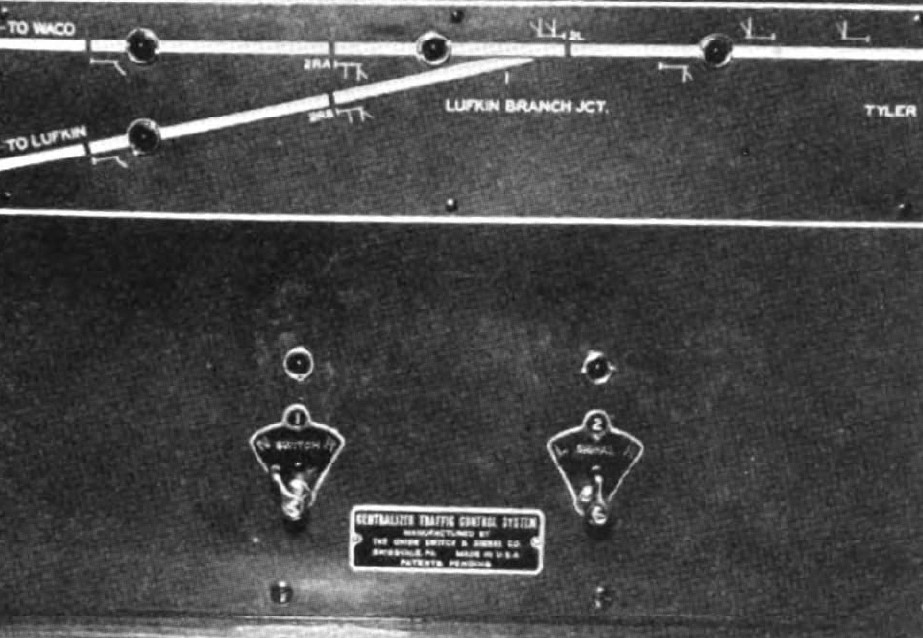
Right: The story
includes this photo of the B-30 control panel. The photo's caption is
"The control panel in the dispatcher's office has an illuminated
track diagram and two levers." |
 |
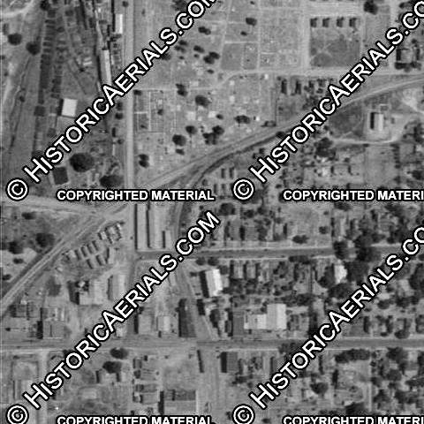
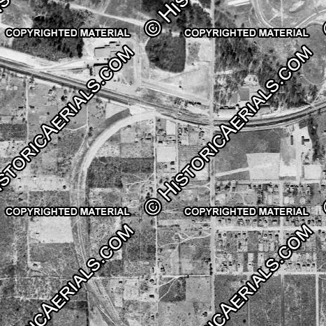
Right: Prior to the
1938 relocation project, this 1934 aerial image shows the Lufkin Branch
curving south off of the SSW main line at the original switch location,
about 400 ft. east of the Palace Ave. grade crossing.
Far Right: This
1947 aerial image shows the new Lufkin Branch switch off the main line
farther west. The switch is about a hundred yards west of the S. Lyons Ave. grade crossing.
To the south, the track immediately crosses
Bellwood Rd. which parallels the main line.
both images ((c) historicaerials.com) |
 |
 |
 |
Left: The
Lufkin Branch relocation project required construction of 1.8 miles of
track between Lufkin Junction and the reconnection point. About 1.3
miles of that track remains intact terminating at this trans-load
facility for aggregates near the intersection of Earl Campbell Parkway
and Old Noonday Road.
Southeast across Earl Campbell Pkwy.,
the 1938 ROW is occupied by Old Noonday Rd. for a quarter mile down to
Frankston Hwy. Old Noonday Rd. terminates there, but the ROW continues
across the highway, curving southwest for a quarter mile to join the
original (1882) ROW to Lufkin.
The entire Lufkin Branch was
abandoned in sections beginning in the early 1980s. The tracks at Tyler
were abandoned c.1987.
(Google Street View, February, 2023) |
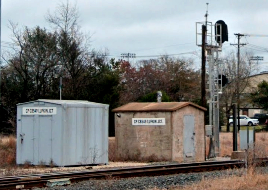 |
Left:
If there was any doubt as to whether Tower 183 controlled Lufkin Jct.,
the presence of a traditional concrete style interlocker cabin at the
switch should be persuasive. This style has been used extensively in
Texas, so much so that it would not be surprising to find that it was
specified by RCT. There are
many other
towers
with the same
concrete cabin.
The
newer style cabin to the
left has the same control point ("CP") sign as the concrete cabin,
presumably as its replacement. This Google Street View image is dated
January, 2023. Street View history shows that the new cabin was
installed between April, 2013 and May, 2021.
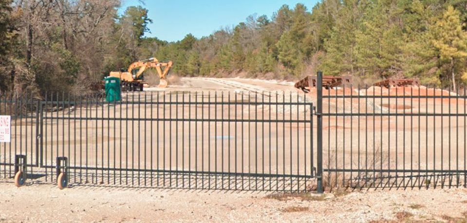
Below: The remnant of
the Lufkin Branch curves across Bellwood and immediately encounters a
Derail sign. The yellow derail device prevents a runaway aggregates car
from rolling out onto the main line. The sign reminds locomotives that
the derail must be deactivated. (Google Street View, Jan. 2023)
 |
In 1956, MP ended a lengthy bankruptcy and merged its various subsidiaries into
a consolidated MP corporation. Along with several others, the I-GN was fully
merged and ceased to exist. Although MP had owned a majority of T&P stock since
the 1930s, the T&P was not a subsidiary; MP had never exercised management control. Instead, the two
railroads collaborated closely on operations by coordinating schedules and
sharing yards and other resources.
In 1968, MP abandoned eleven miles of
former I-GN track between Mineola and Lindale, serving Lindale solely from Tyler. In 1979, MP abandoned another 2.7 miles
south from
Lindale followed by another 3.2 miles in 1984. Today, the tracks
are physically intact nearly to Swan, but they are out of service, completely overgrown to the point
that it is not worth scrapping them. If they are used at all north of the SSW crossing,
it would only be for railcar storage (and not very many of them until they cut
down the trees that have grown up between the rails!) South of the crossing, the tracks
are in place to just beyond Main St. in Whitehouse, but Google Street View
imagery from 2023 shows that they are out of service on the southeast side of
Tyler beyond R. L. Lilly Rd. where they are marked with a red board. Beyond that point, the
tracks are completely overgrown. Satellite imagery suggests that a nearby
customer still has service. Jody Garner's 2008 email noted that "The
American Standard air conditioning plant receives tank cars of Freon." ...
and this appears to now be a Trane plant, which seems appropriate!
In
1976, MP acquired the remaining shares of T&P stock and took executive control, merging it into MP and retiring the T&P
name. In 1982, Union Pacific (UP) acquired MP, but MP continued to
operate under its own name. In 1988, UP bought the Katy and merged it into MP,
reuniting the two railroads a century after the Texas courts had broken MP's
lease. The Katy had survived as an independent railroad all of that time, but
another receivership was looming and UP wanted the Katy's tracks, many of which
were complementary to those of MP. The Cotton Belt became fully merged into SP in 1992,
and soon thereafter, UP and SP began discussing a merger. The merger was
consummated in 1996 with UP as the surviving corporation. In 1997, UP fully
merged SP and MP, and began operating exclusively under the UP name.

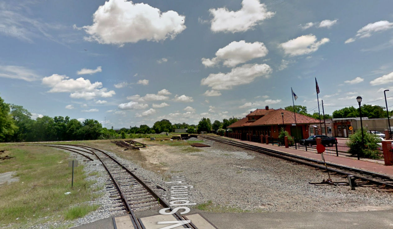
Above: This
Google Street View image from June, 2019 faces north along the former I-GN. The
gate, its mounts, two poles and the nearby cabinet have all been
removed since the 2005 photos (the distant cabinet remains standing at far right.)
Note the proximity of the depot building to the diamond -- this might be the
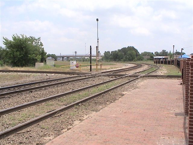
closest such positioning in Texas. Below: Also from
June, 2019, this Google Street View facing east from N. Spring Ave. shows that
one connecting track remains in place in the northwest quadrant. This appears to
be the only quadrant that has ever had a connecting track.