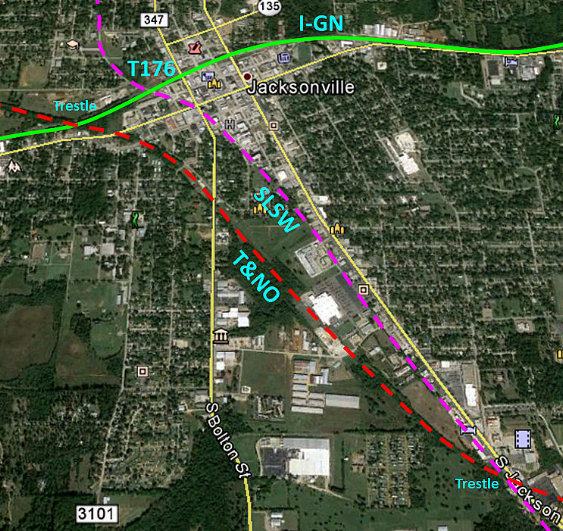
Texas Railroad History - Tower 176 and Tower 201 - Jacksonville
A Crossing of the St. Louis
Southwestern Railway and the International & Great Northern Railroad

Above: The John W Barriger III
National Railroad Library supplies this photo Barriger took from the rear platform of
his business car as he passed through Jacksonville, probably in the mid 1930's. The view is west-southwest
along the
tracks of the International & Great Northern (I-GN)
Railway, with the St. Louis Southwestern ("Cotton Belt") Lufkin Branch
crossing in
the foreground. This was the location of Tower 176; the interlocker was a swing gate (note the "STOP" sign hanging from the bottom
rung) that connected to the post at right when the
gate was positioned to allow movements on the Cotton Belt. The gate was
normally closed against the Cotton Belt; opening it
would trigger distant signals to warn approaching I-GN trains to plan to stop at
the home signal short of the crossing. Just
beyond the diamond is the Patton St. grade crossing. The Texas & New Orleans (T&NO) freight
station, served by a spur off the T&NO main line, is visible at far left. The large fill in the distance carried the
T&NO over the I-GN,
just beyond the camera's view. Below:
This Google Street View from June 2019 faces southeast on Patton St., a
90-degree view compared to Barriger's shot. In his photo, the Google camera would
have been adjacent to the crossbuck and facing down
Patton Street to the left. The image below shows the remnants of the T&NO freight
depot directly ahead. The Tower 176 gate was to the left; the connecting post
mentioned above would be near the equipment cabinet but much closer to the
tracks. Elevated ground along the left side of Patton St. beyond the tracks
provides a hint of the former Cotton Belt grade.

When the International Railroad bypassed the original
site of Jacksonville in 1872, the townspeople reacted by relocating the town two
miles east to be on the railroad. A year later, the International merged with
the Houston & Great Northern Railroad to form the International & Great Northern
(I&GN) Railroad. By the end of 1873, the combined railroad operated three major
rail segments: Longview to Palestine via Jacksonville, Palestine to
Hearne, and
Palestine to Houston. The excellent rail connections provided by the I&GN helped
Jacksonville to grow and become the center of agricultural business in the area, increasing local commerce
and attracting more railroads.
The I&GN had financial problems throughout
its early history, and when it came out of yet another receivership in 1922, it
was re-chartered as the International - Great Northern Railroad (hence, the use
of "I-GN"
instead of "I&GN".) At the time, it had more than 1,100 miles of track in Texas,
but its repeated financial reorganizations had weakened its executive leadership and made it an
attractive target to be acquired by a larger railroad. The St. Louis San
Francisco Railway tried to buy it in 1922 but was turned down by the Interstate
Commerce Commission (ICC). Missouri Pacific (MP) tried to buy it in 1924 as a
means of penetrating the Texas market, but again, the ICC nixed the sale. MP's
fallback strategy was to arrange for a "friendly" railroad, the New Orleans,
Texas & Mexico (NOT&M) Railway, to buy the I-GN, simply to keep it out of the
hands of competitors. The NOT&M had a route network from Brownsville to
New Orleans that made it a similarly attractive acquisition target. The sale of
the I-GN to the NOT&M was approved by the ICC in June, 1924, and MP bought the
NOT&M on January 1, 1925 with approval from the ICC. The I-GN was now part of
MP, but continued to operate under its own name until 1956.
The next town south of Jacksonville
was Rusk. In 1875, Rusk was designated as the site for a new penitentiary by the
Texas Legislature, leading to increased commercial
investment in the area. One of these investments was the founding of the Rusk
Transportation Company in 1875 which built a 17-mile wooden tram road from Rusk
to Jacksonville, the nearest town served by rail. The wooden rails were a
failure, and the Rusk Transportation Company soon entered bankruptcy. The
remnants of the tram ended up as the property of the Kansas & Gulf Short Line
Railroad in 1881, which used portions of the right-of-way in completing
construction of a new railroad between Rusk and Tyler via Jacksonville.
Eventually, this rail line became the property of the St. Louis Southwestern
Railway (SSW), commonly known as the "Cotton Belt". The I-GN and Cotton Belt
crossed at grade close to the yards of both railroads near downtown
Jacksonville. This crossing was uncontrolled until 1931 when an interlocker was
commissioned by the Railroad Commission of Texas (RCT) as Tower 176.
Noted Texas railroad historian David Bernstein explained the genesis of the
interlocker in an
April, 2019 email:
"Tower
176 protected the Cotton Belt - I-GN (MP) crossing at Jacksonville, placed in
service September 8, 1931. It
was a manual interlocking without an operator, with protection by automatic
block signals on the I-GN and an electrically locked gate on the Cotton Belt
(normally lined for MP movement). In 1954, Tower 176 was replaced by an
automatic interlocking designated Tower 201 which remained in service until the
Cotton Belt was abandoned in 1991."
Assigning a new number to an automatic interlocker that
was replacing a manual interlocker was something RCT had not done
previously. By the early 1950's, various manual interlocking towers had been
dismantled at active crossings in favor of automatic interlockers without new
number assignments (e.g. Tower 31.) The reason for
the assignment of a new interlocker number for Jacksonville remains unknown.
In 1902, the Texas & New
Orleans (T&NO) railroad built through Jacksonville as part of an agreement with
the State of Texas to complete a line between Dallas and Beaumont. The T&NO was
owned by Southern Pacific (SP) and had become the subsidiary into which most of SP's
Texas and Louisiana lines were consolidated. Out of Jacksonville, the T&NO went northwest to
Athens and Dallas, and southeast to Nacogdoches and Beaumont.
In Jacksonville, the T&NO used trestles to cross over the other two
railroads; the I-GN crossing was west of downtown and the Cotton Belt crossing
was south of town.
South from Jacksonville, Rusk was becoming an
important source of traffic for the Cotton Belt. In addition to various industries
established there to take advantage of inexpensive
convict labor, the prison itself operated a foundry built to exploit east Texas iron
ore. To haul wood and iron ore to the foundry, the state of Texas had built a
railroad in 1896 extending five miles west from the prison. Rails were extended
five miles
farther west in 1906. That year, Thomas M. Campbell, a native
of Rusk and a former General Manager of the I-GN, was elected Governor of Texas.
It was his idea to extend the Texas State Railroad (TSR) 22 miles farther west
to Palestine where an I-GN connection could be made. This would create
competition for freight rates on inbound materials and outbound foundry products
since, at the time, only the Cotton Belt served Rusk. The extension to Palestine
was completed in 1909, the same year that the T&NO decided to build a branch
into Rusk. Their 8-mile circuitous route to Rusk was known as the "Gallatin
Branch", named for a tiny community southeast of Jacksonville where the branch
departed the T&NO main line. Only a year later, the prison foundry closed;
its charcoal-based furnaces were unable to compete economically with coke-based
furnaces elsewhere. In 1917, the prison
closed and some of its facilities were converted to the Rusk State Hospital,
which became another source of
passenger and freight traffic for the three railroads serving Rusk. In 1921,
SP leased the TSR from the state of Texas and assigned it to the T&NO.
In 1932, SP gained control of the Cotton Belt but
elected to operate it separately rather than merge it with the T&NO.
The two railroads worked cooperatively for their common owner, and one of
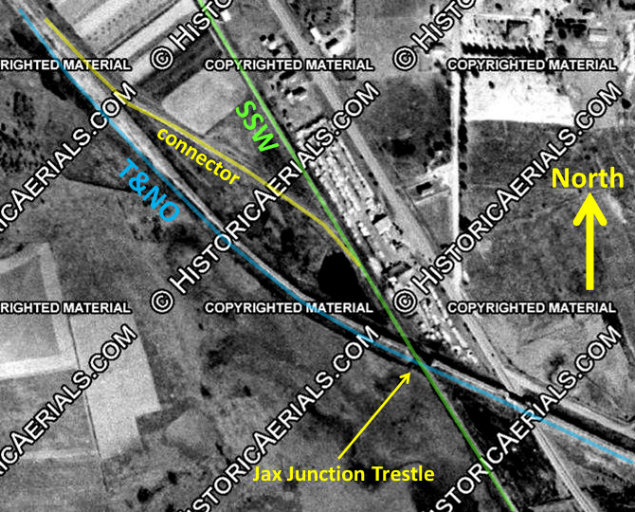
the early changes was the abandonment of T&NO's Gallatin Branch in 1934. The
Cotton Belt line from Jacksonville to Rusk was shorter than T&NO's roundabout
path via Gallatin. A connecting track between the T&NO and Cotton Belt was put in
place at their crossing on the far south side of
Jacksonville, approximately 1.5 miles south of Tower 176. This became known as Jax Junction
which T&NO trains began using
to reach Rusk. On May 31, 1934, the Interstate Commerce Commission approved
T&NO's application to abandon the Gallatin Branch.
Today, only the former I-GN/MP
tracks remain in use through Jacksonville, now owned by Union Pacific (UP). The Cotton
Belt tracks survived until abandonment in 1991. The T&NO was abandoned through
Jacksonville ten years earlier, although Southern Pacific retained 2.4 miles of
former T&NO trackage at that time to continue serving customers via the Cotton
Belt tracks.
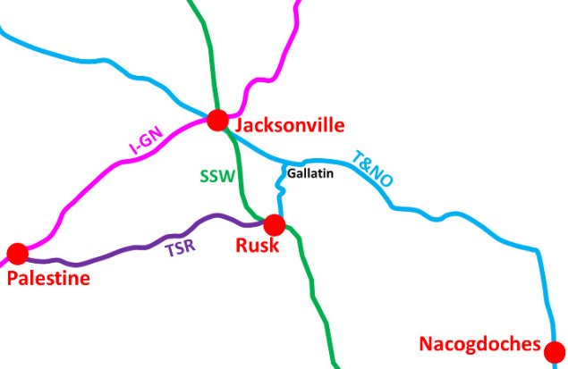
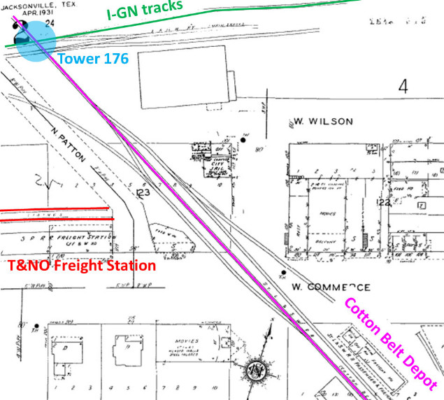
Above Left: historic
rail lines in the vicinity of Jacksonville
Above Right: Sheet 2 of the
1931 Sanborn Map of Jacksonville has been annotated to show the location of
Tower 176 with respect to the Cotton Belt Depot (passenger and freight) and the
T&NO Freight Station. The T&NO tracks (red) to the freight station came off the
main line well south of the T&NO's trestle over the I-GN (off image to left),
and ran north before curving east to the reach the depot.
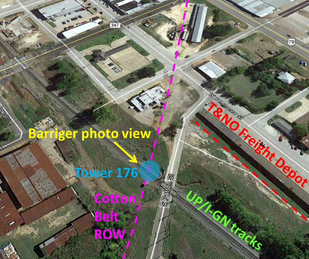
Below Left: (annotated Google
Map) Facing southeast, slight evidence of the Cotton Belt right-of-way parallel
to Patton St. can still be found, e.g. the warehouse aligned to the ROW. The
Barriger photo was taken facing west southwest on the I-GN tracks at the Tower 176 gate. The tracks serving the
T&NO freight depot came in from the lower right. The T&NO spur to the depot came
off the T&NO main line south of their trestle over the I-GN (off image to the
right) and went north before curving to the east to the freight station.
Below Right: Jax
Junction is the crossing in the lower right corner of the image. The connecting
track was located between the two railroads north of the Jax Junction trestle,
permitting southbound T&NO-to-SSW movements and northbound SSW-to-T&NO
movements.
Below Left: This 1947 image ((c) historicaerials.com)
shows the T&NO/SSW connecting track at Jax Junction.
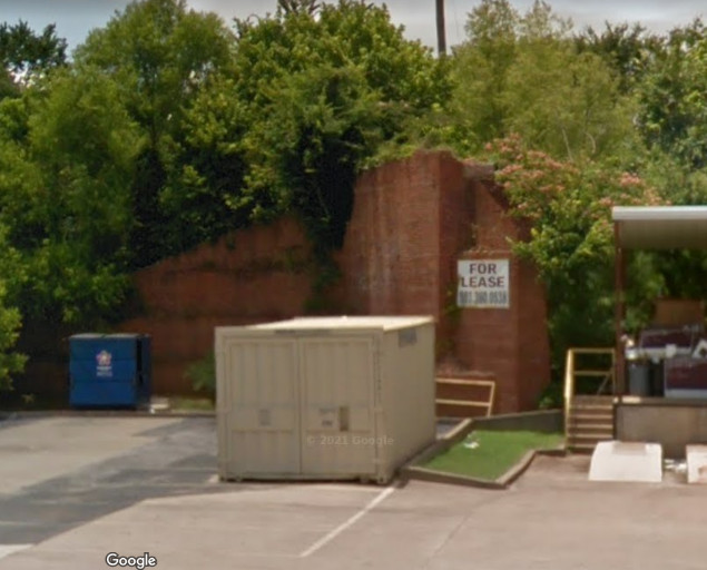
Below Right: Apparently, you
can lease the north abutment of the former T&NO trestle over the Cotton Belt at
Jax Junction. Its utility might be rather limited. (Google Street View, June
2019)
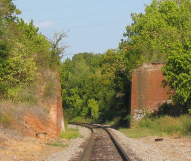
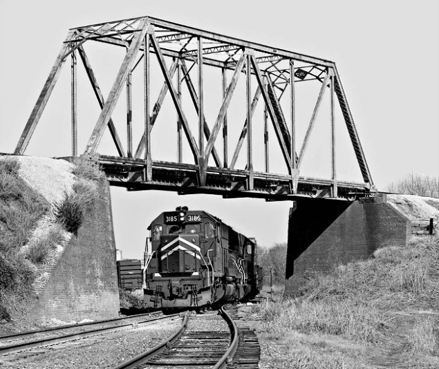
Above Left: The T&NO no longer
passes over the UP's MP/I-GN tracks, but the concrete abutments remain intact.
(Jim King photo, 2006) Above Right:
A southbound MP freight goes under the T&NO bridge in April 1969. (Center for
Railroad Photography & Art, J. Parker Lamb photo)
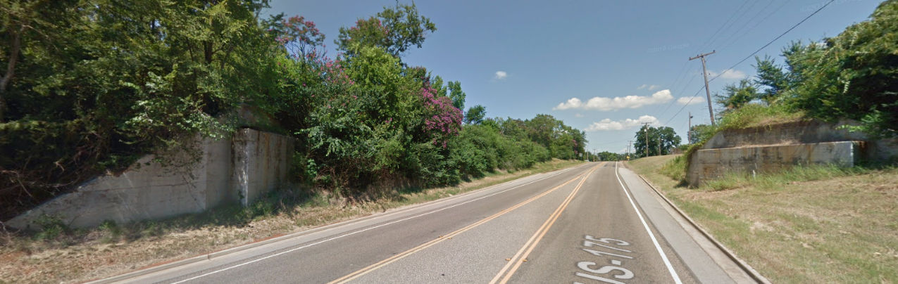
Below: On the north side of Jacksonville, the abutments
for the Cotton Belt bridge over U.S. 175 were still in place when this Google
Street View image was captured in June, 2016, and they remain in place as of
January, 2022.