Mathis News, January 26, 1951
A Crossing of the San Antonio, Uvalde & Gulf (SAU&G) Railroad and the San Antonio & Aransas Pass (SA&AP) Railway
|
|
Mathis News, January 26, 1951 |
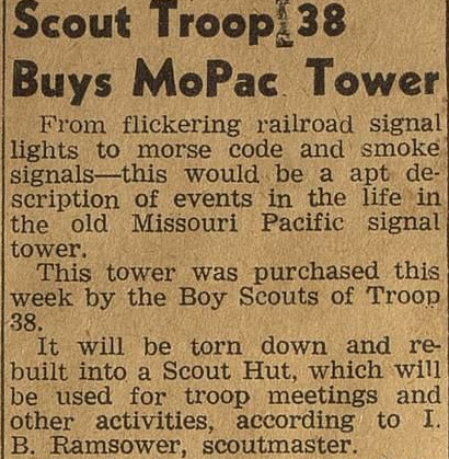
Left: In January, 1951, the Mathis News announced that local Troop 38 of the Boy Scouts had purchased the "old Missouri Pacific signal tower". This structure had been commissioned as Tower 159 on November 7, 1929 by the Railroad Commission of Texas (RCT). It housed a 22-function mechanical interlocking plant that governed the crossing of two railroads near downtown Mathis: the San Antonio & Aransas Pass (SA&AP) Railway, a subsidiary of Southern Pacific (SP); and the San Antonio, Uvalde & Gulf (SAU&G) Railroad (nicknamed "the Sausage"), a subsidiary of Missouri Pacific (MP, but also abbreviated MoPac). The SAU&G had created the crossing as the second railroad to arrive, so by RCT regulations, it was responsible for the capital outlay to build the tower and acquire the interlocking plant and associated signals. Typically, the same railroad was also tasked with staffing and maintenance, hence Tower 159's identification as the "MoPac Tower" in the headline (not "Sausage Tower" as the SAU&G was no longer in common parlance though it remained a legal entity until 1956.) That the tower was staffed at all was highly unusual for this timeframe. The vast majority of new interlockers in the latter 1920s were either unmanned cabins where train crews would stop to operate the controls, or they were interlockers with manual controls remoted to a nearby depot and operated by staff as necessary. Like almost all manned towers, Tower 159 was two stories. It was the last -- hence, the most recent -- two-story interlocking tower built in Texas, yet no photo of it has been found. |
Mathis was established in 1887 when the San Antonio &
Aransas Pass (SA&AP) Railway built across land owned by cattleman Thomas Mathis during
construction of a rail line from Skidmore to Alice. The SA&AP had only recently
completed its line from San Antonio to
Corpus Christi, and the construction through Mathis
was a branch off of that main line at Skidmore, fourteen miles northeast of
Mathis. The branch's destination was the town of Alice, thirty miles southwest
of Mathis. The Texas Mexican (TM) Railroad had built through Alice on its route between
Corpus Christi and Laredo, where an international bridge connected with the
Mexican railways. The SA&AP's idea was to gain access to Mexican
traffic by interchanging with the TM at Alice. Mathis was surrounded by extensive ranch
lands with massive cattle herds, so an unusual plan was developed to build a cattle fence
around the entire perimeter of the town. "As late as 1906, the land designated
as the townsite of Mathis was still fenced in -- there was still a big, plank,
double gate at the Virgin Wright home on the West and just below the Lon Porter
home on the East..." (Mathis News,
November 7, 1963, discussing the town's history.)
Mathis was still
primarily a cattle ranching center when the San Antonio, Uvalde and Gulf (SAU&G)
Railroad crossed the SA&AP there in 1913 during construction of a competing line between San Antonio and Corpus
Christi. The SAU&G had been chartered as the Crystal City & Uvalde Railroad in
1909 and had begun by building lines in the western part of South Texas between
its namesake cities, and between Crystal City and Gardendale. It became the
SAU&G in 1912 as the railroad completed a line from Gardendale to Fowlerton. An extension between Fowlerton and San Antonio via Pleasanton was
accomplished in 1913, and from Pleasanton, the SAU&G built south toward Corpus
Christi that same year. The tracks crossed the SA&AP in Mathis in the fall of
1913. The crossing was most likely gated at that time, and it would be sixteen
years before Tower 159 was built.
 Above: Aransas Pass Progress, Nov. 22, 1912 Right: Aransas Pass Progress, Jan. 31, 1913 |
 |
 |
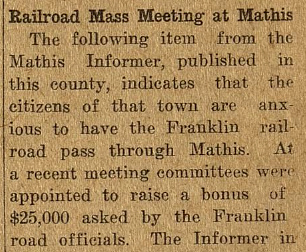
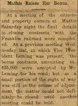
The promoter behind the SAU&G was John E. Franklin, the
President of Bankers' Trust Co. of St. Louis. In November, 1912,
Franklin asked the citizens of Mathis to come up with a $25,000 bonus
for his railroad to build through their town and cross the SA&AP there.
The town agreed, and by the end of January, the money had been raised
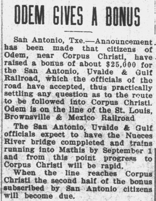
and the deal was nearly complete. The route south of Mathis remained in flux until the SAU&G agreed to build through Odem and curve around the north end of Nueces Bay to reach Corpus Christi. At Odem, the SAU&G crossed the St. Louis, Brownsville & Mexico (SLB&M) Railway. An electric locked gate was eventually installed there but the crossing was never interlocked within RCT's numbering system. Left: The San Patricio County News of July 18, 1913 reported that the SAU&G expected to have trains running into Mathis by September 1. |
The Bankers' Trust Co. went into receivership in
August, 1914, causing the SAU&G to be placed into receivership by a
Federal judge in Texas. The railroad continued to operate under Bankruptcy
Court supervision until December, 1925 when the receivership was terminated and
the SAU&G was sold to the New Orleans, Texas & Mexico (NOT&M) Railway. The
NOT&M operated under the moniker Gulf Coast Lines (GCL) and had been a MP subsidiary for about a year. The GCL had originally been
an affiliation of several railroads (including the aforementioned SLB&M) operating along the Gulf coast from
Brownsville to New Orleans under the control of B. F. Yoakum, President
of the St. Louis San Francisco ("Frisco") Railway. In 1914, the Frisco had
entered receivership, and as a result, the GCL had been reorganized so that a
single corporate entity would own the component railroads (since the Frisco no
longer did.) The new parent company, the NOT&M, was incorporated in 1916 for
this purpose, and it operated independently until MP
bought it on January 1, 1925.
Also in 1925, SP acquired the SA&AP (for the second time! --
see Tower 2) and leased it to one of its Texas-based
subsidiaries, the Galveston, Harrisburg & San Antonio Railway. In 1934, SP consolidated
most its Texas and Louisiana railroads into a single operating entity,
the Texas & New Orleans (T&NO) Railroad, including all of the
components of
the SA&AP.
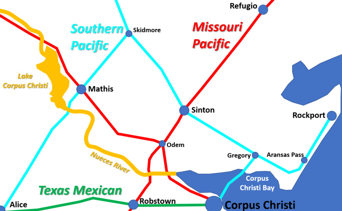 |
Left: This map
depicts the track topology and ownership after the acquisitions of the
SA&AP and SAU&G in 1925 by SP and MP, respectively. Most of the tracks
are still intact and operational, the major exceptions being the SP
tracks north of Sinton through Skidmore and beyond (abandoned 1994-95),
and the SP branch from Skidmore through Mathis to Alice (abandoned 1979.) South of Sinton, the
SP tracks still serve Gregory and Aransas Pass but they no longer
continue to Rockport (abandoned 1985.) The line from Gregory to Corpus
Christi was taken out of service in the early 1960s. Union Pacific (UP) owns
all of the SP and MP
tracks. The Texas Mexican Railroad is owned by Kansas City Southern. Although it does not own tracks
here, Burlington Northern Santa Fe has trackage rights on the former
SLB&M line, and serves Corpus Christi on the former SAU&G line from Odem. There are also switching railroads that
handle industrial trackage along the coast. Besides Tower 159 at Mathis, the other numbered interlockers historically present on this map were at Sinton (Tower 193), Robstown (Tower 197) and Corpus Christi (Tower 211). Odem had an electrically locked gate that was probably tied into local signals, but it was not managed within RCT's numbering system. There was a crossing of the Texas Mexican and the SA&AP at Alice, but it was not interlocked. |
The SA&AP had started to build south beyond Alice in
1904 with a 36-mile extension to Falfurrias. The plan was to continue south to
the Rio Grande Valley at Edinburg and McAllen, but this was delayed for legal
and financial reasons until after the SA&AP was acquired by SP in 1925. Under SP
ownership, the SA&AP
built the Falfurrias - McAllen line in 1927 as well as a line from Edinburg east to
Brownsville. There is no doubt that the sudden increase in traffic through
Mathis attributable to SP's new line into the Valley influenced the decision to
interlock the Mathis crossing, hence Tower 159 became operational in November,
1929. The MP depot was nearby and could have housed any necessary remote
controls or status indicators for the interlocker. Instead, the railroads opted
to build a two-story, manned tower, suggesting that they anticipated
substantial Valley traffic over the diamond with switching activity that would
necessitate direct visual observation by tower personnel. Otherwise, a remotely
operated interlocker or an unmanned cabin interlocker would have been
sufficient. Seven cabin interlockers had
already been commissioned at other MP / SP crossings in South Texas in the
previous twelve months dating back to December, 1928 (specifically,
Edcouch, Lantana,
Rosita,
Allenhurst, Blessing
and two interlockers at Edinburg.) Thus, buildingaatwo-storytwo-story,
manned tower in Mathis was certainly unusual.
 Railway Signaling, December, 1942 |
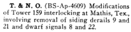
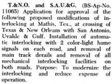
Left:
In the late fall of 1942, the railroads submitted to the Interstate
Commerce Commission (ICC) a request to permit removal of specific
derails and dwarf signals at Tower 159. The changes to the track layout
that motivated this request are undetermined. Right: Railway Signaling and Communications in January, 1950 carried this summary of the application to the ICC requesting permission to remove the mechanical plant at Tower 159 and replace it with an automatic interlocking, primarily to eliminate the labor expense of staffing the tower. MP was subsequently able to sell the tower to the the local Boy Scout troop for salvage purposes in January, 1951 several monthsafterrthe new interlocking had been installed.the new interlocking had been installed. |
 |
The ICC approved the new automatic interlocker at Mathis, confirmed by a 1955 T&NO employee timetable listing it as such. A 1967 MP employee timetable showed the Mathis crossing continuing to be an automatic interlocking.
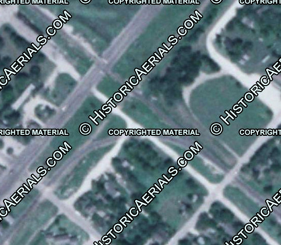
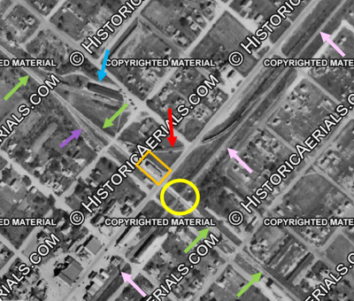 Left:
This aerial image ((c)historicaerials.com) from 1951 has been annotated to identify the railroads in
Mathis. The green arrows mark the path of the MP, with the
tracks toward San Antonio at upper left and the tracks toward Odem at lower
right. SP's tracks are marked by pink arrows, with the line to Skidmore at
upper right and the line to Alice at lower left. The Tower 159 crossing is
within the yellow circle, but the tower is not visible; it had been
removed in February and the image dates from June of that year. The cabin that housed the new interlocking plant is the
white dot within the yellow circle, where it continues to sit today. The MP depot is trackside (orange
rectangle) near the crossing. Behind the MP depot, an exchange track (red
arrow) is visible in the north quadrant. Two MP spurs are also visible: one was merely a short stub
track (purple arrow) and the other served a vegetable warehouse (blue arrow).
Left:
This aerial image ((c)historicaerials.com) from 1951 has been annotated to identify the railroads in
Mathis. The green arrows mark the path of the MP, with the
tracks toward San Antonio at upper left and the tracks toward Odem at lower
right. SP's tracks are marked by pink arrows, with the line to Skidmore at
upper right and the line to Alice at lower left. The Tower 159 crossing is
within the yellow circle, but the tower is not visible; it had been
removed in February and the image dates from June of that year. The cabin that housed the new interlocking plant is the
white dot within the yellow circle, where it continues to sit today. The MP depot is trackside (orange
rectangle) near the crossing. Behind the MP depot, an exchange track (red
arrow) is visible in the north quadrant. Two MP spurs are also visible: one was merely a short stub
track (purple arrow) and the other served a vegetable warehouse (blue arrow).
 Near
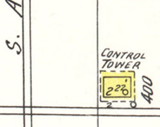
Left: The only Sanborn Fire Insurance map of Mathis, from June,
1950, depicts
Tower 159 as a "Control Tower" adjacent to the MP tracks. The drawing shows a two-story tower 22
ft. in length with door openings ("o") on both levels. The roof (dashes)
overhangs the lower story by two feet on all sides. The map was drawn five
months after the request to ICC to retire Tower 159. Since no staircase is shown,
perhaps the new
interlocker was already in place and the staircase had been removed to
prevent vandalism.
Near
Left: The only Sanborn Fire Insurance map of Mathis, from June,
1950, depicts
Tower 159 as a "Control Tower" adjacent to the MP tracks. The drawing shows a two-story tower 22
ft. in length with door openings ("o") on both levels. The roof (dashes)
overhangs the lower story by two feet on all sides. The map was drawn five
months after the request to ICC to retire Tower 159. Since no staircase is shown,
perhaps the new
interlocker was already in place and the staircase had been removed to
prevent vandalism.
 |
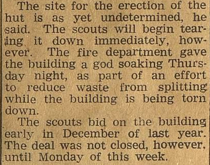
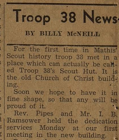
Left:
Within a week of closing the deal to buy the "old Missouri Pacific
signal tower", the Scouts of Troop 38 began razing the structure to
salvage its wood for construction of a new Scout Hut. (Mathis
News, February 2, 1951) Right: The Mathis News of October 18, 1951 announced that Troop 38 had finally been able to hold its first meeting in their new, official Scout Hut. For reasons unknown, the hut was a former Church of Christ building rather than a structure built from the salvaged Tower 159 materials. |
 |
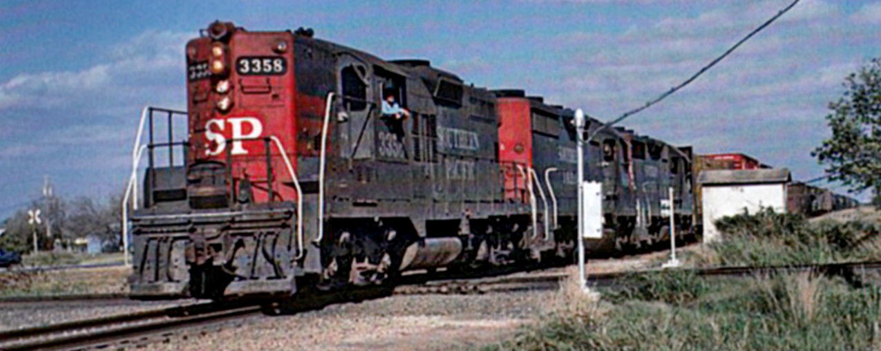
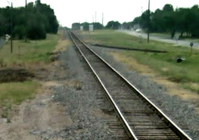
Above: John Carr took this
photo of a southbound SP locomotive crossing the MP tracks at the Tower 159
automatic interlocker on December 8, 1977. The train had originated at Ennis and
was heading to Brownsville. The white cabin housed the interlocking plant, and
the adjacent chrome post held its manual override controls. The box on the near
post most likely houses a telephone for communicating with the dispatcher.
(photo from Southern Pacific's Eastern Lines 1946
- 1996 by David M. Bernstein, published by the North Texas Chapter,
National Railway Historical Society)
SP abandoned the entire line from Skidmore to Edinburg in 1979 and began using MP's tracks to reach the Valley. The trackage rights agreement included havingMPMP purchase 0.8 miles of SP tracks in Mathis to maintain service to one or more businesses southwest of the crossing. Access was provided by a new south quadrant connector built specifically for this purpose.
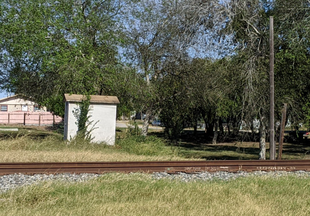
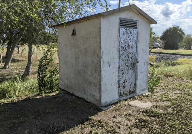
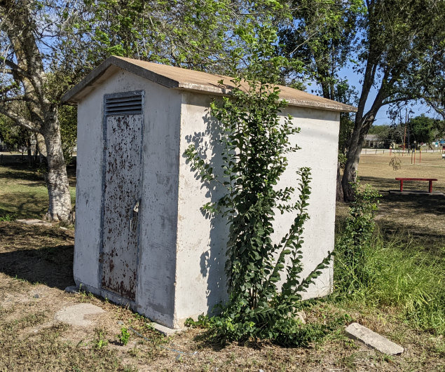
These photos of the cabin
at the former Tower 159 crossing were taken on October 28, 2022 and show that it still
has the "159" identification stenciled on one side (below
right.) The
cabin sits in the east quadrant of the former X-pattern crossing, and the door
faces the abandoned SP right-of-way. Commercial establishments now occupy much
of that right-of-way northeast of the cabin (e.g. one is visible in the
upper left photo.) The former MP tracks, now owned and
operated by UP, are several yards southwest of the cabin (upper
right.) This is undoubtedly the cabin installed in 1950 to house
the automatic interlocking plant. The access door would have served maintenance personnel and the
cabin could, in theory, also have housed the manual override controls that would
occasionally be necessary. An external post-mounted control box was a
more typical arrangement, e.g. Tower 70 at Dobbin,
but no such post remains at the crossing. The cabin door is locked (below
left); does it still serve some purpose for Union Pacific?
The full history of the Mathis cabin and what's behind its locked door remains to be discovered. (Jim King
photos)
 |
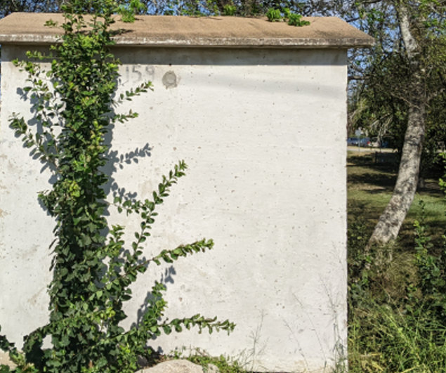
Left:
This October, 2020 Google Earth image has been annotated to show what's
left of the former Tower 159 crossing. The cabin (pink circle) sits
directly adjacent to the abandoned SP right-of-way (ROW) shaded by large
trees in the neighboring city park.
Below: This June, 2022 Google Street View shows the Tower 159 cabin near the trees. The area gets regular maintenance; the images above from four months later show substantially less vegetation along the side of the cabin. 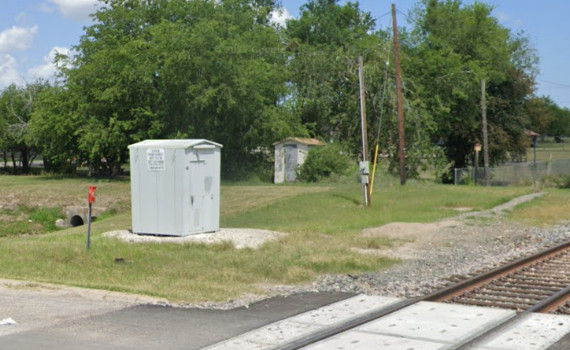 |
Above Left: This view from
April, 2011 lookingnortheastnortheast along the former SP tracks toward the Tower 159 crossing shows that
the connecting track was still intact in the south quadrant. The Tower 159 cabin is visible beneath the trees.
Above Right: The connecting
track, howeverwas no
longer connected to the UPthe UP line southeast of the Tower 159 crossing.
(Google Street View) Below Left:
The south quadrant was added c.1979 so that MP could access the SP tracks
southwest of the crossing. ((c)historicaerials.com, 1981)
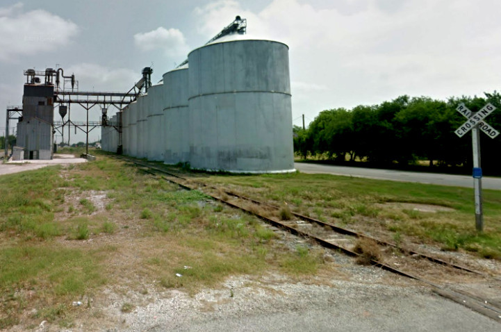
Below Right: This Google
Street View looking northeast along the former SP right-of-way in April, 2011
shows tracks still intact to the Mesquite St grade crossing (and continuing a
few dozen yards beyond it, behind the camera.) Maintaining rail service to these
silos appears to be why the south quadrant connector was added, although there
may have been other businesses served closer to downtown. Since the line was out
of service by April, 2011, the tracks were presumably removed shortly thereafter
(and were definitely gone by December, 2015.)
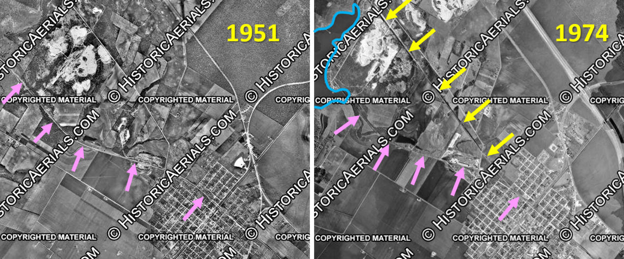
Above: These aerial images ((c)historicaerials.com) have
been annotated to show the MP tracks (pink arrows) and the realignment
(yellow arrows) that was necessitated by the impoundment of Lake Corpus Christi
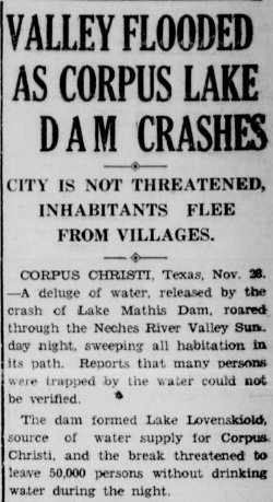
(blue outline) in 1958. The first attempt to dam the Nueces River in this area was
called the La Fruta Dam, completed in 1929 to impound Lake Lovenskiold (more
commonly called Lake Mathis.) The dam failed on November 22, 1930 causing
catastrophic flooding downstream but no loss of life. The Nueces River was
reported to be four miles wide as water settled across the lowlands south of the
dam. A new structure was completed in 1933 known as Mathis Dam, and the lake
continued to be known unofficially as Lake Mathis. The City of Corpus Christi owned the
water rights to the lake which was part of their municipal water system. Whether MP had to realign its tracks in the late 1920s or early 1930s for Lake Mathis
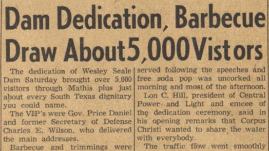
has not been determined. However, when the City of Corpus Christi decided to
build the new and much higher Wesley Seale Dam, MP had to realign its
tracks to avoid the much greater expanse of the new Lake Corpus Christi in the
vicinity of Mathis. Lake Corpus Christi impounded nine times as much water as
Lake Mathis. Below Left: The 1951 aerial imagery does not show that any realignment was
required for the SP tracks (blue arrows). Its bridge over the Nueces River (pink
circle) southwest of
Mathis was already a half mile downstream from where the new Wesley Seale Dam (yellow
dashes) would be completed in 1958, and it was about three quarters of a mile downstream from the Mathis
Dam (green arrow) built in 1933. Whether the tracks were realigned when the La Fruta Dam had been constructed
in 1929 to create the initial reservoir in this area is
undetermined, but a substantial curve in the SA&AP right-of-way between Mathis
and the river suggests that realignment might have been necessary.
Below Left: annotated 1951 aerial
image,
(c)historicaerials.com Below Center:
Delta Courier, November 25, 1930
Below Right:
Mathis News, May 2, 1958