Texas Railroad History - Towers 141 and 142 - Lubbock
and Plainview
Automatic Interlockers at Two Crossings of the Pecos & Northern Texas Railway and the Ft. Worth & Denver
South Plains Railway
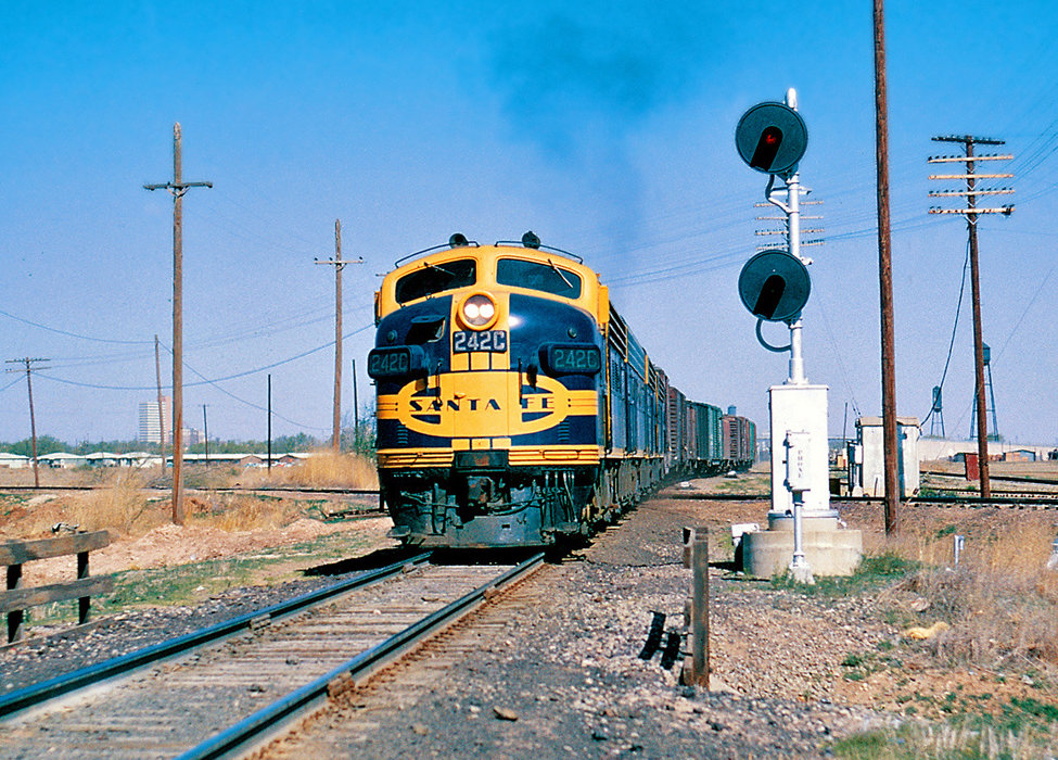 |
Left: On April 11, 1964, Joe
McMillan took this photo of Atchison, Topeka & Santa Fe (AT&SF) Extra 242C East crossing the Fort Worth &
Denver (FW&D) tracks at Tower 141 in Lubbock. The view is to the northwest
with the train moving southeast out of Lubbock on Santa Fe tracks toward Slaton. Tower 141 was the first crossing in Texas to use an automatic interlocker
which controlled access to the diamond using train detection sensors,
electronic relays, logic and timing circuits, and trackside signals.
Tower 141 commenced operation on February 12, 1931 with the
interlocking plant housed in the light gray concrete cabin with the
light tan roof visible across the FW&D tracks (partly obscured by a
utility pole.) In front of the cabin, a post is visible holding a box
that housed manual controls that train crews could use to override the
interlocker as necessary. It was common to have a separate override box
for each railroad, typically adjacent to one another, but from this
angle, it is difficult to discern whether a second post-mounted box is
present. There is a similar post-mounted box directly in front of the
camera, but whether it is related to the interlocker, or perhaps just a
trackside telephone, is undetermined.
The Great Plains Life Building
is visible
in the background to the left. It opened in 1955 and today is known as
Metro
Tower. |
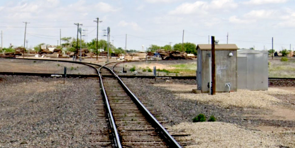 |
Left: A virtually
identical cabin sits at the Tower 142 crossing in Plainview in this May,
2023 Google Street View. It is no longer functional, replaced by the
silver cabin behind it. Tower 142 commenced
operation on March 16, 1931. This view is north from E. 9th St. along the tracks of Burlington
Northern Santa Fe (BNSF), successor to the AT&SF. The curve to the left beyond the diamond
is the BNSF main line to Canyon and
Amarillo. Behind the camera, the tracks continue
south to Lubbock.
The right branch beyond the diamond was Santa Fe's line to
Lockney and Floydada
but it now serves businesses on the east edge of Plainview and ends. The former
FW&D tracks cross at the diamond and proceed west to Dimmitt (left.)
In the other direction, the tracks are intact for 3.8 miles from the
Tower 142 diamond, used as a lengthy industry spur, having previously
continued to Sterley and Estelline. |
In 1886, the Fort Worth & Denver City (FW&DC) Railway
completed tracks into Vernon from
Fort Worth on its way to the
far northwest corner of Texas where it would connect with a railroad under
construction from Denver. At about the same time, the Atchison, Topeka & Santa
Fe (AT&SF, "Santa Fe") Railway chartered its Southern Kansas Railway (SKR)
subsidiary to build tracks from Kansas through Oklahoma into the Texas
Panhandle. The SKR crossed into Texas in 1887 and stopped construction in 1888
at the newly founded town of Panhandle City. Santa Fe had expected to find the FW&DC
tracks nearby. Despite an agreement to connect, the FW&DC route had passed
fifteen miles farther south through the new town of Washburn. Enterprising
investors had already chartered the Panhandle Railway to cover the distance
between Washburn and Panhandle City. In April, 1888, trains began operating
between Fort Worth and Denver, passing through Washburn and the new town of
Amarillo, fifteen miles west of Washburn.
Shortly thereafter and many
miles to the south, noted railroad investor James J. Hagerman built the Pecos
River Railroad in 1890 between Pecos, Texas and Roswell, New Mexico. The railroad
was mostly a bust, and Hagerman soon realized that the market for crops grown in the
Pecos Valley was north. There was also plenty of cattle to be shipped
from ranches in southeastern New Mexico to the stockyards in Kansas City. In
1896, Hagerman decided to build in that direction knowing he could reach
Santa Fe's tracks to Kansas City through a connection with the SKR. The obvious
connecting point was Washburn at the south end of the Panhandle Railway. Santa
Fe agreed to connect there because it was already planning to
lease the Panhandle Railway (which it did in the spring of 1898; it then bought the Panhandle Railway in 1900.)
Hagerman's route plans changed after Amarillo
civic leaders sent an emissary to Santa Fe headquarters in Chicago and offered a
$20,000 bonus. The route was revised
northward out of Canyon City (named for its proximity to Palo Duro
Canyon) to proceed directly into Amarillo instead of Washburn. Hagerman was
happy; Amarillo had been his original preference for a connecting point since it
was the commercial center of the Panhandle region. As required by Texas law,
Hagerman solicited a railroad charter and formed a company to own the tracks he
planned to build in state. The charter was granted in 1898 for the Pecos &
Northern Texas (P&NT) Railway, and its tracks between Roswell and Amarillo were completed
in February, 1899. From Washburn, the SKR had negotiated rights to use the FW&DC
tracks to Amarillo, hence the P&NT connected at Amarillo directly with the SKR, but on FW&DC tracks. In 1901, Hagerman sold the P&NT and his New Mexico
railroads to Santa Fe, a move that surprised no one.
In 1908, Santa Fe
opened the Belen Cutoff which intersected the Roswell - Amarillo main
line at Farwell, Texas on the Texas / New Mexico
border. The Belen Cutoff provided a shortcut for Los Angeles / Kansas
City traffic by connecting to Santa Fe's Los Angeles main line at Belen, New
Mexico. West coast traffic began moving between Belen and Kansas City via Farwell and Amarillo
instead of via Raton Pass (on the New Mexico / Colorado border) and Lamar,
Colorado. The
opening of the Belen Cutoff coincided with new Santa Fe tracks
between Panhandle City and Amarillo. This facilitated abandonment of the
Panhandle Railway as Santa Fe no longer needed to route through Washburn.
For both short term and long term reasons, Santa Fe needed a route from the
Amarillo main line deeper into the plains south
of Canyon City. Cattle ranching was the primary
commerce, but commercial production of
wheat and cotton was increasing. For many miles, Plainview and Lubbock were the
only towns of any size south of Canyon, but both were very small and neither had
rail service. Using the P&NT charter, Santa Fe began construction in 1906 by
branching south from the main line at Canyon City toward Plainview, 56 miles
away. Lubbock was 42 miles farther south, the county seat of Lubbock County. It
had been founded by land promoters in 1891, although a Lubbock Post Office had
been granted for a tiny outpost in the county in 1884.
 |
 |
Plainview had been founded
c.1886 through the efforts of two settlers,
Z. T. Maxwell and Edwin Lowe, who had simply decided to establish a town
near their land. Having secured a post office in March, 1887, Plainview
became the county seat when Hale County was organized in 1888.
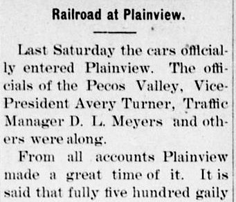
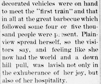
Left: The weekly Canyon
City News of Friday, January 4, 1907 reported the arrival of
the first train into Plainview the prior Saturday, December
29, 1906. Note that the "officials" were from the Pecos Valley Railroad
(PVR),
i.e. the P&NT simply held title to the tracks Hagerman had built in Texas;
it was
the PVR (based in New Mexico, owned by Santa Fe) that actually used them.
This persisted until 1914 when the SKR was renamed the Panhandle & Santa
Fe (P&SF) Railway under which all of Santa Fe's west Texas operations
(including the PVR's operations on the P&NT) would be consolidated.
Since the P&NT owned most of the tracks the P&SF was using, it was
leased to the P&SF and then formally merged in 1948. The P&SF was merged
into the parent AT&SF on August 1, 1965. |
| Right:
Having completed its line to Plainview, Santa Fe needed to update the P&NT charter
before it commenced
further construction in the
South Plains. Santa Fe's planning was public information, as exhibited by this July, 1909 excerpt
from a magazine produced by and for Santa Fe employees. The passage is
mostly verbatim from the charter amendment. It references a 300-mile
line between Coleman, Texas and Texico, New Mexico. Texico is the community across
the border from Farwell. |
 |
 |
Santa Fe waited until 1909 to begin additional
construction south from Plainview toward Lubbock. When an unplanned opportunity
arose early in the year involving the town of Floydada, a branch from Plainview
to Floydada was incorporated into the P&NT charter amendment. It never went
beyond Floyd County and thus was never close to the "70 miles" envisioned by the
amendment. In his book A History of the Texas Railroads
(St. Clair Publishing, 1941), author S. G. Reed
described how it came about. Referring to the Canyon - Plainview branch, Reed
explains that in 1909...
...the
citizens of Floydada had decided to build a road of their own to connect with
this new branch of the Santa Fe at Canyon City, 27 miles away. ... Floydada did the grading, and
then in March, 1910 sold out to the Santa Fe, which completed the line by May,
1910. Meanwhile the Santa Fe was being extended from Plainview a distance of 46
miles to Lubbock, which was placed in operation on January 9 of that year.
Reed mistakenly cites Canyon City as the destination; it is
Plainview that is 27 miles from Floydada. Construction began at Plainview (since
materials could be shipped there by rail) and proceeded to Lockney before
turning southeast to Floydada.
It appears likely that Santa Fe took over the construction
between Plainview and Floydada earlier than the March, 1910
sale timeframe that Reed identified. The Lockney Beacon
(quoted in the Thursday, February 17, 1910 edition of the
Crosbyton Review) reported the track-laying machine entered
Lockney "...Tuesday evening at
about 6:30 o'clock...almost the whole of the population of the city were
present to witness the important event." This implies February 15,
1910 as the date for track-laying in Lockney, a task undoubtedly handled
by Santa Fe. The machine was headed toward Floydada and it would
not take long to get there. Reed asserts that the line was completed by
May, 1910, but the Snyder Light quoted by the Abilene Daily Reporter of
March 29, 1910 reported "...Santa Fe has inaugurated
train service on the new branch line from Plainview to Floydada."
 |
Left: Reed's assertion that the Plainview -
Lubbock line began operating on January 9, 1910 encounters mixed support
when looking at contemporary newspaper reports. That date doesn't square
with this notice published in the
Crosbyton Review of Thursday, October 28, 1909 announcing that "regular passenger service" had been inaugurated by Santa
Fe on Monday, the 25th with a train that arrived at Lubbock from
Plainview at 5:00 pm. The return trip through Plainview to Amarillo
departed at 8:00 am the next morning. The dateline of October 25
explains the future tense of the article (e.g. "will reach Lubbock",
"leaving...Tuesday"); the events had not yet occurred, but
they had
by the time
the item was published three days later in Crosbyton's weekly newspaper.
Right: On the other
hand, Reed's date
matches this item from the
Hereford Brand of January 14, 1910. It quotes the
Lubbock Avalanche (date unknown,
likely January 2nd) stating that "telegraphic communication was established" January 1st,
and that "...regular passenger train service ... will be established
Sunday, January 9th." Perhaps Santa Fe's "regular passenger service"
reportedly inaugurated on October 25, 1909 (left) had been
terminated and then reinstated in January? The article implies another
noteworthy oddity: as of the last day
of 1909, Lubbock did have long distance
telephone service but it did
not have telegraph service. |
 |
A major
effort was made to connect Lubbock with the westward main line out of
Temple built by Santa Fe's Galveston-based
Gulf, Colorado & Santa Fe (GC&SF) Railway subsidiary. Its construction had
terminated at Coleman in 1885 but the line had been used almost exclusively to reach a branch to
San Angelo that connected five miles east of
Coleman (resulting in Coleman being at the end of a 5-mile stub track for 25
years.) Surveyors began working on a northwest route out of
Coleman in 1909, and trains between Temple and
Sweetwater were operating by November, 1910. The
Snyder Signal of Friday, May 19, 1911
reported that "the first through train on the Santa Fe between Sweetwater and
Lubbock passed through Snyder Sunday." While the opening of this route facilitated
direct service between Houston and California via Temple, Lubbock, Canyon and
Farwell to reach the Belen Cutoff, Santa Fe intended to build a direct line between Lubbock and Farwell.
Known in the press as the Lubbock - Texico Cut Off, construction began
in 1912 from both endpoints. The track was initially completed in November,
1913, but telegraph lines, water stops and additional ballasting delayed the
official opening until March 1, 1914. This was exciting news in Galveston which
stood to gain faster service to and from the west coast. The
Galveston Tribune of February 19, 1914 quoted
the Los Angeles Examiner commenting that the
cut-off would save "...more than 100 miles of the distance between this city
and the gulf port, and with the direct connection, will mean a saving of 24
hours in time."
In 1910, the Crosbyton South Plains
Railroad was chartered by local interests to build 39 miles between
Crosbyton and Lubbock. The line was completed in 1911, bringing rail
service to the communities of Ralls, Lorenzo and Idalou along the line. Santa Fe
purchased the railroad in 1915, changing its name to the South Plains & Santa Fe
(SP&SF) Railway, and leased it to the P&SF in 1917. Santa Fe used the SP&SF charter to build
branches from Lubbock to Bledsoe and Seagraves, west and southwest,
respectively. The construction to Bledsoe completed the track plans embodied in
the 1909 P&NT charter update although the P&NT charter was not used for the
Bledsoe branch. The Crosbyton branch was not mentioned in the P&NT amendment; it
was strictly an unplanned opportunity. The only item in the amendment that was
not accomplished was the extension of the Floydada branch beyond Floyd County
into Crosby and Dickens counties.
 |
In the mid-1920s, the
FW&DC began an aggressive push to gain Interstate Commerce Commission
(ICC) approval for proposed routes into the South Plains. In 1927, the
newly chartered Fort Worth and Denver South Plains (FW&DSP) Railroad
started construction on a branch from the FW&DC main line at Estelline,
80 miles southeast of Washburn. The line ventured west to penetrate the
Caprock Escarpment, requiring two tunnels to reach the community of
South Plains atop the escarpment, 23 miles east of Plainview. The tracks arrived in Plainview in 1928 and continued west
to Dimmitt that same year.
The FW&DSP also built a new line from
Lubbock to Silverton that crossed the Santa Fe tracks at Lockney between
Floydada and Plainview. This line was unusual because neither end
connected to existing FW&DC tracks. Silverton had no railroad at all,
and the P&SF was the only other railroad at Lubbock. This
would have been an "orphan line" except that it crossed and
connected with the new FW&DSP
Estelline - Dimmit line at a tiny rural outpost where the community of Sterley arose, named for the railroad's general agent, W. F. Sterley.
Trains on the FW&DC main line out of Fort Worth could proceed
northwest to
Estelline, turn west to Sterley and then turn south to Lubbock. This
provided the first efficient "single railroad" passenger service between
Fort Worth and Lubbock. Previously, Lubbock - Fort Worth travel required
changing railroads (and depots) at
either Amarillo (FW&DC) or Sweetwater (Texas & Pacific.) The FW&DC's new
construction undoubtedly benefitted commerce between north
Texas and the South Plains, but it put Santa Fe management in a dour
mood. The South Plains had been Santa Fe's exclusive territory for
twenty years.
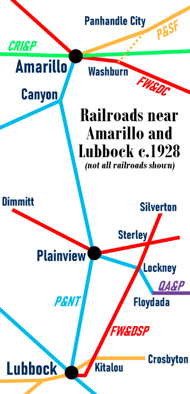
Left: This overview map shows the railroads in
the vicinity of Amarillo and Lubbock c.1928, though not all rail lines
are shown. After the SKR extended its line from
Panhandle City to Amarillo in 1908, it immediately abandoned the tracks
between Panhandle City and Washburn. The Chicago, Rock Island & Pacific
(CRI&P) had crossed those tracks in 1904 at a rural outpost, Yarnall,
where the abandonment resulted in
the closure of Tower 48. The
family that had lived adjacent to the tower and provided all operations
and maintenance staffing promptly moved to Amarillo to take charge of
the new (Tower 75) interlocker project underway, necessitated by the SKR track
extension from Panhandle City.
In 1927, the P&SF decided to upgrade its yard at
Canyon which included installation of an electric interlocker to manage
yard tracks. Santa Fe's belief was that an interlocker installation for
yard management purposes with no other railroads involved did not
require the Railroad Commission of Texas (RCT) to approve the design.
RCT felt otherwise, and Tower 135 was commissioned for Santa Fe's Canyon
Yard in December, 1927. The same situation applied a few months later in
Pampa, a town northeast of Panhandle
City.
The 1928 FW&DSP construction at both
Lubbock and
Plainview created the need for the interlockers
commissioned as Towers 141 and 142, respectively. The FW&DSP also
crossed the P&SF at Lockney and Kitalou, but there was little
traffic and thus no need to interlock these crossings; they were gated,
allowing restricted speed approaches. Also in 1928, the Quanah, Acme &
Pacific (QA&P) built into Floydada and connected to the P&SF, but there
was no actual crossing and no need for an interlocker.
Southeast of Lubbock, the Santa Fe
line went to Slaton which had been selected as the connecting point for
the line from Coleman via Sweetwater. This became the main line straight
through to Lubbock. A branch was built in 1911 from Slaton to Lamesa. |
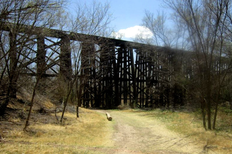
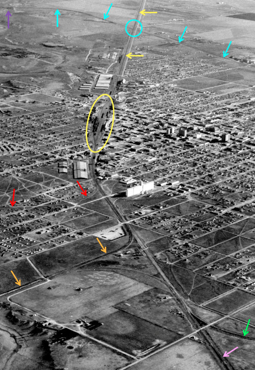
Right: This 1928 aerial image of Lubbock
from the National Archives has been annotated to show rail lines
and other features. The image faces southeast with the Santa Fe
yard (yellow oval) near the center. The main line to Slaton (yellow
arrows) crosses the FW&DSP tracks (blue arrows) at Tower 141 (blue
circle.) On the north side of town, the Santa Fe main line to Plainview
and Canyon (orange arrows) curves to the north while Santa Fe's other
main line (pink arrow) continues northwest to Farwell on the New Mexico
border. The Santa Fe branch line
from Crosbyton (red arrows) comes in from the east. The branch line
(green arrow) that switches off of the Farwell line in the lower right
corner curves to a southwest heading and proceeds to Seagraves. After
5.5 miles, another branch switches off of the Seagraves line and heads
due west to Bledsoe. The FW&D trestle (purple arrow) over the North Fork of the Double
Mountain Fork of the Brazos River is
faintly visible in the upper left corner. The trestle remains standing but closed (below,
photo courtesy Facebook / I Love Lubbock.)
 |
 |
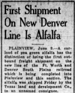
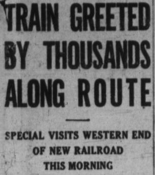
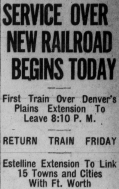
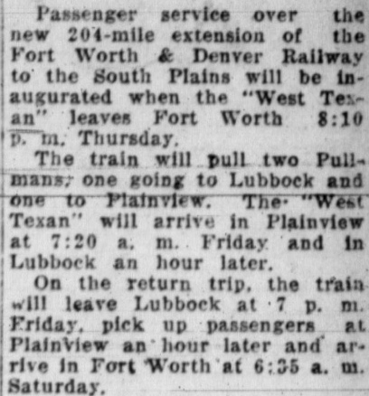
The FW&D's Estelline - Plainview line opened in June, 1928. The railroad
initiated freight operations but did not start passenger service to Plainview.
In November when the Silverton - Lubbock track was completed, FW&D began freight service
to Lubbock. Passenger service from Fort Worth to both towns via Sterley was
initiated on Thursday, November 22.
 |
 |
Far Left:
Amarillo Sunday News-Globe,
June 10, 1928
Left:
Amarillo Daily News, November
21, 1928; the FW&D sent a VIP train from Fort Worth to celebrate the new service at Plainview and Lubbock.
Right:
Fort Worth passenger service to Plainview and Lubbock started
Thursday, November 22, 1928. Note "City" already being dropped from the
FW&D's name. (Fort Worth
Press) |
 |
 |
Less than a year after inaugurating service to Lubbock, the crash of the New
York Stock Exchange in October, 1929 foretold the coming of the Great
Depression. By 1931, the FW&D's daily train serving the South Plains from Fort Worth
could no longer be justified. As Mike Bartels explained in a 2018 post to
Facebook's Texas Railroad History Group...
...business waned and the Lubbock sleeper came off, then the Plainview car. On
November 29, 1931, it was replaced with daytime service from Childress. Then the
train began making a side trip to Plainview from Sterley, adding about an hour,
and it arrived in Lubbock after midnight. It was shown as a motorcar train for a
number of years.
The FW&DSP was the "second railroad" at Lubbock and Plainview, i.e. it created
the crossings and thus the necessity for the interlocking plants. Hence, by RCT
rules for post-1901 crossings, the FW&DSP would bear the entire capital cost for
both interlockers. Based on the assigned tower numbers, it appears likely that
the FW&DSP's initial proposals were received by RCT in 1927. A "file number" for
design and approval documentation was typically assigned by RCT when it began to
receive correspondence from the railroad(s) associated with a proposed
interlocking. The file number became the tower number and it provides a basic
chronology of when railroads received RCT validation of a need for an
interlocking so that the design phase could commence. It
is not a precise chronology of when any specific tower was commissioned,
however, simply because the time needed to design, manufacture, install, inspect
and approve interlocking plants and associated trackside signals varied considerably based on the local circumstances. Yet, even
allowing 6 to 18 months as a reasonable range for the start-to-finish completion
of most interlockers, the commissioning dates for Towers 141 and 142 deviate
significantly from that range.
Tower 144 (to cite one example) was
commissioned on May 29, 1928, implying that its initial application to RCT was
probably made sometime in the latter part of 1927. This would imply a 1927 or
earlier date for the initial applications for the Lubbock and Plainview
interlockers since they have lower numbers. Yet, the operational dates for Tower
141 and 142 are much later than Tower 144's. Tower 141
was commissioned for operation by RCT at Lubbock on February 12, 1931 and Tower
142 began operation in Plainview on March 16, 1931, i.e. about three years after
Tower 144. There were 19 interlockers with numbers higher than 142 that
were commissioned in 1930 or earlier, i.e. months
or years before Towers 141 and 142. (The next interlocker,
Tower 143, is not among those. It had unique
circumstances that resulted in a commissioning date several years
earlier than its tower number would imply!) The lengthy implementation phase for Towers 141 and 142
stemmed from their proposed designs as the first automatic interlockers in Texas
and the first Texas interlockers that would not
have derails. Whether these features were proposed by FW&DSP from the outset is
undetermined. Though there is no specific evidence, it is certainly possible that the idea
of using automatic interlockers was suggested to the
railroad by the RCT engineering staff as a means of advancing the state of the
art for interlockers in Texas. Both interlockers were
ideal for testing this new (for Texas) technology because, lacking derails, they
had only 7 and 8 functions, respectively.
RCT held a
hearing in Austin on March 31, 1930 to discuss the proposal, and then issued an order granting
it on May 1, 1930. The order (below) was conditioned on RCT's final approval of some specific
revisions to the signal plan, and it mandated a speed limit across
the interlockers of 20 miles per hour. The order cites American Railway
Association research in favor of eliminating derails from
all interlockers, and notes that 121 automatic
interlockers were in operation across the U.S. without any reported accident
attributable to interlocker automation.
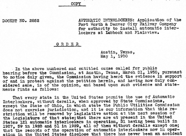 |
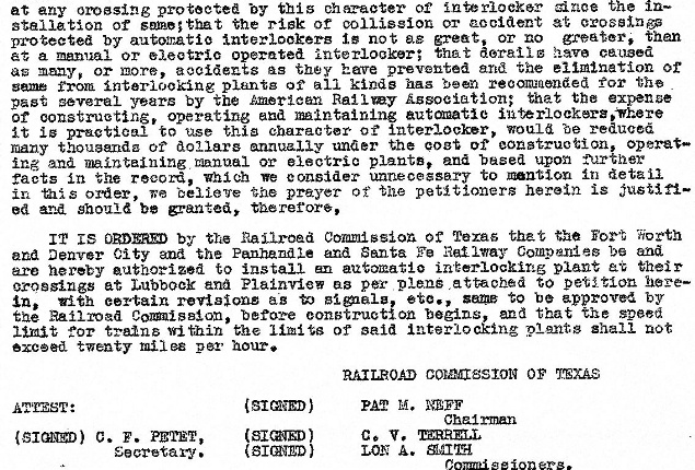
Houston Metropolitan Research Center, courtesy Stephen Hesse |
In the above order, RCT identified the P&SF and the
FW&DC as the participating railroads and specifically noted that it was ruling
on FW&DC's application for installation authority for both interlockers. RCT's annual report
references the P&NT and the FW&DSP as the participants in both
interlockers, but this was simply
because those corporations held legal title to the tracks. RCT's annual report
also identified the FW&DSP as the railroad that "operates the interlocker"
for both locations. Operational staffing did not directly apply in the context of automatic
interlockers, so it's likely that the FW&DSP was listed simply because its
parent company, the FW&DC, shouldered the
non-recurring cost of procuring and installing the systems at both locations and
/ or because the FW&DC (presumably) had the maintenance responsibility.
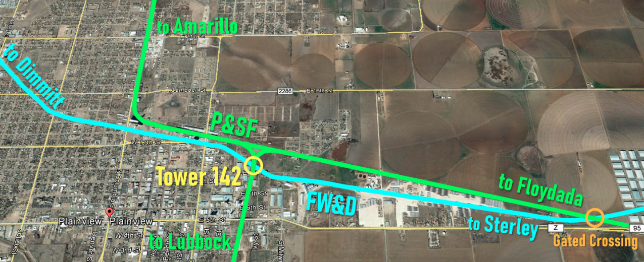
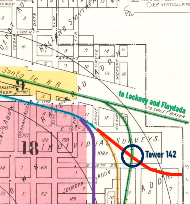
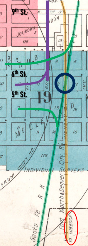
Above: This annotated Google
Maps satellite image of Plainview shows that
there were actually two crossings of the P&SF and the FW&D (and both
exist today.) The P&SF main line from Amarillo came into Plainview on a due
south heading. It then curved to an east southeast heading for about three
quarters of a mile before turning back to a nearly due south heading to Lubbock.
Where the turn to the south toward Lubbock was completed, the P&SF crossed the
FW&D tracks at Tower 142. The branch line to Floydada continued the main
line's 104-degree ESE heading, and after two miles crossed the FW&D tracks to
Sterley at an acute angle. This crossing was gated, but it later became the site
of Tower 213 in the 1960s. The FW&D line from Estelline and
Sterley came in from the east, crossed the P&SF branch line and then turned
slightly north to parallel the P&SF tracks through town, crossing the P&SF main line
at Tower 142. On the west side of town, the tracks eventually curved more to the
northwest toward Dimmitt.
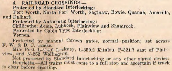 |
Left: This
excerpt from the FW&DC Wichita Falls and
Amarillo Divisions Employee Time Table No. 5 dated June 20,
1937 lists the locations where the FW&DC crossed other railroads.
Plainview and Lubbock are shown with Automatic Interlockings. Crossings
that are "Protected by manual thrown gates, normal position;
set across F. W. & D. C. tracks" include Kitalou near Lubbock
and one "east of Plainview" at milepost P-321.7, two miles
from Tower 142 (noted elsewhere as P-323.7.) Note that
Henrietta was neither interlocked nor gated
at this time, and thus, "All trains must come to a full stop..." Since
this warning is not included for gated crossings, the implication is
that trains could approach at restricted speed and continue across the
diamond if the gate was open.
Below: Rejecting the straight track approach, the 1937 timetable's
subdivisions show that Silverton was paired with Dimmitt while Lubbock
was pared with Estelline ("Plains Junction"). Both subdivisions passed
through Sterley and shared a diamond there but technically did not
cross.

 |
| The Mystery of the 1931 Sanborn Fire
Insurance Map of Plainview |
After the Civil War, insurance firms began to adopt
the English system wherein detailed maps were created in advance to provide the
information necessary for risk assessment in fire insurance underwriting. For
many properties, maps could eliminate the need to travel to perform an
inspection. Daniel Sanborn had begun creating maps under contract to the Aetna
Insurance Co. in 1866, and he founded the largest and most successful mapping
company for the fire insurance industry, the Sanborn Map Co. Sanborn maps
provide a treasure trove of historic details for towns throughout the U.S. For
Plainview, the earliest Sanborn map is dated April, 1910 and the final map is
dated July, 1931. During the Great Depression, the company began to publish
updated details to the most recent map for a town instead of performing completely new surveys. Thus, Sanborn published a September,
1943 "correction" to the July, 1931 map of Plainview.
Unfortunately, the 1943
update did not correct numerous apparent mistakes
in the July, 1931 map. The most serious errors are associated with the physical
route of the FW&D tracks, hence the mistakes do not exist on the next earlier Sanborn
map of Plainview published in 1927
because the FW&D did not build through Plainview until 1928. The 1931 map was
the final map -- there was never another survey, only the 1943 update of no
significance. The image snippets below are taken from the 1931 Sanborn index map of
Plainview except where noted.
Above Left:
As of 1931, the northwest side of Plainview was just beginning to be developed
as the "Lake Side Addition", a residential area. The map shows the FW&D tracks
(blue highlight) curving in a northerly direction to depart Plainview toward
Dimmitt. But Dimmitt is northwest of Plainview, not north. Up to the 16th St. grade crossing
(purple circle), the tracks are accurately mapped, but the route continued on a 313-degree
northwest heading, not the more northerly route shown on the
map. Thus, the map plots the FW&D crossing of 20th St. between Milwaukee and Nassau streets,
more than a quarter mile east of its actual
20th St. crossing (green circle.) The best explanation for this mistake is that
the purpose of the index map was to show numeric identities of the underlying
detailed maps, i.e. index maps did not directly support underwriting other than
to summarize general town information (e.g. population.) As there were no
detailed maps north of the FW&D's 16th St. grade crossing, the cartographer
simply sketched the route based on a vague notion of where it went rather than
making an effort to survey the route or obtain maps from the railroad with
accurate information.
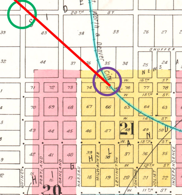
Above Right:
The mistakes on the east side of Plainview are more serious. The FW&D tracks (blue highlight) are accurately
mapped
from downtown to the 10th St. grade crossing. There, the map shows the FW&D
curving to a due south heading, but those tracks (orange highlight)
never existed. The FW&D tracks actually assume a 125-degree
southeast heading (red) between 10th St. and 9th St., crossing Santa Fe's line
to Lubbock (green highlight) at Tower 142 (dark blue circle.) Just past the 9th St.
grade crossing, the FW&D curves back to a 99-degree heading continuing off
the map to the right toward Sterley. The FW&D is parallel to and south of Santa Fe's branch line
which is on
a 104-degree ESE heading, hence the two railroads cross about two miles farther
east. That gated crossing verifies the history of the track orientation that exists today,
i.e. the current
track topology has been in place at least since the publication of the 1937
FW&DC employee timetable cited above which lists the FW&D's crossings of the
Santa Fe branch line and main line precisely two miles apart (at mileposts
P-321.7 and P-323.7, respectively.) The 1931 map omits even the possibility of the
gated crossing since it shows the FW&D turning south. Note that Santa Fe's branch was headed to Lockney and Floydada, not Sweetwater
as labeled on the map. Santa Fe's line to Sweetwater proceeds southeasterly out
of Slaton, not Plainview. The FW&D also had an industry spur (purple) that branched off near the Fir
St. grade crossing and turned due south aligned with Grove St., which was
platted in this area but was only a railroad right-of-way. (Note that it was
standard practice to omit industry spurs from index maps, as was done here.) The FW&D spur ended
farther south along
the west side of the Magnolia Petroleum Oil Depot located on the southeast
corner of Grove and 6th St. (see below.) Perhaps the southward turn of this
industrial spur confused the cartographer into drawing the main line turning
south?
Right:
The non-existent FW&D track (orange highlight) continues due south,
purportedly with a destination of Lubbock (red oval), but the FW&D never
had a direct line between Plainview and Lubbock; Santa Fe did (green highlight)
and still does (as BNSF.) The crossing of the two lines (blue circle)
between 5th and 6th St. ostensibly would have been the location of Tower
142, but with no FW&D track, the crossing did not exist. A Santa Fe
industry track did cross the FW&D spur (purple) nearby. Did the
cartographer simply misread his notes? A city map in the 1928 - 1932
timeframe might be helpful, but neither the Plainview Library nor the
Hale County Historical Commission are able to provide one.
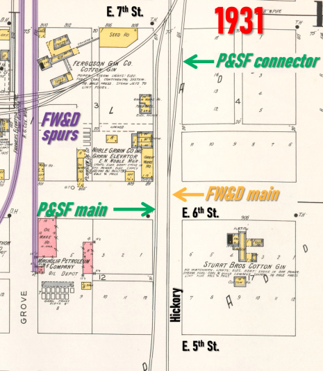
Above: A comparison of the
details of Map 19 for 1927 (left)
and 1931 (right)
reveals the distortions required by the phantom main line of
the FW&D down Hickory St. The most striking change is that a P&SF siding
for the Noble Grain Co. (1927) is extended to become the P&SF main line
(1931.) On E. 7th St., that siding switched off of a P&SF spur (1927),
hence that spur is also the P&SF main line, but only because it is
switched off of the "straight through" spur track to the west (1931.)
Thus, the track on the real P&SF main line (1927) south of the spur
switch (which is barely off the top of both maps) can't be left dangling,
so it gets converted into a
connecting track onto the (imaginary) FW&D going south (1931.)
Below: The index
map for the 1943 "correction" adds a short spur (red oval) where the FW&D main line
actually continued east to Sterley, a detail
 that
does not appear on the 1931 index. The
spur is shown terminating short of crossing the P&SF at Tower 142. Why?
Obviously the track was there and operational to Sterley in 1943, just
as in 1931. This suggests
that the errors on the 1931 map had been recognized during the 1943
update, but there was no charge to re-survey Plainview and no way to fix
the errors without potentially introducing new ones in lieu of a correct survey. that
does not appear on the 1931 index. The
spur is shown terminating short of crossing the P&SF at Tower 142. Why?
Obviously the track was there and operational to Sterley in 1943, just
as in 1931. This suggests
that the errors on the 1931 map had been recognized during the 1943
update, but there was no charge to re-survey Plainview and no way to fix
the errors without potentially introducing new ones in lieu of a correct survey. |
 |
FW&D's 1937 timetable shows that the crossing on the
east edge of Plainview was gated, at least by then and almost
certainly at the outset. In 1928, it would have been rare to omit a gate at any
new crossing that involved a main line or branch line. The gated crossing
might have been
considered for inclusion in Tower 142's interlocking plant, but it was enough of an experiment for Lubbock and
Plainview to be the first two automatic interlockings with their relatively
simple crossings. Adding the complexity of a full crossing two miles distant
would have been too much, if it was even a possibility. The traffic anticipated through the gated crossing
apparently
didn't warrant an interlocker on its own or RCT would have required one. It was
later interlocked as Tower 213.
At the
end of 1982, the FW&D was merged into its parent company, Burlington Northern
(BN), successor to the Colorado & Southern which had owned the FW&D for decades.
In 1991, the FW&D line between Estelline and the east side of Plainview was abandoned by BN, and
the following year, BN abandoned the Sterley - Lubbock tracks. This left BN with
the Plainview - Dimmitt tracks as its only presence in the South Plains. BN's
successor, BNSF, continued to operate between Plainview and Dimmitt until 2007
when the line was sold to the West Texas & Lubbock Railroad, owned by
transportation company Iowa Pacific. Along with the two branches out of Lubbock,
the Dimmitt line was acquired by the LBWR in 2015.
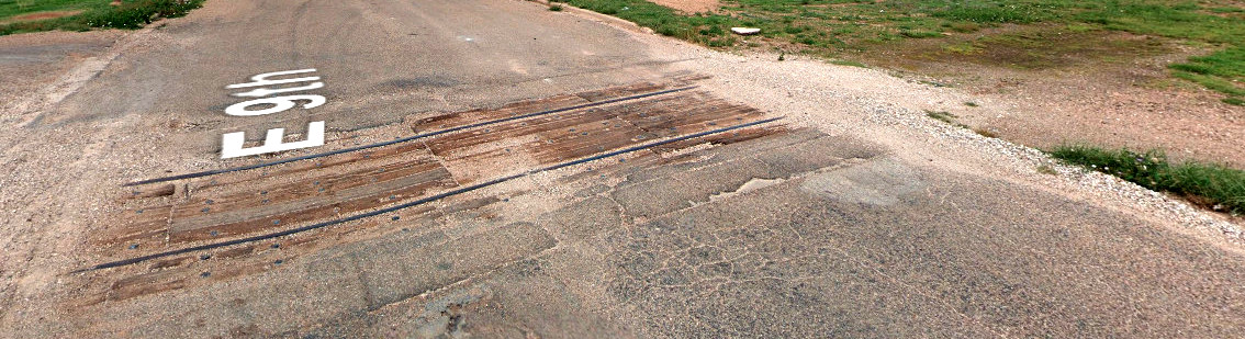 |
Left: The FW&D
spur at Plainview that branched off of the main line at 10th St. crossed
9th St. about 535 ft. west of where BNSF's ex-Santa Fe tracks cross 9th
St. The spur was taken up long ago,
but rails remain intact in the pavement on 9th St. Rails for this spur are also
present in the 6th St. pavement farther south. (Google Street View, May,
2023) |
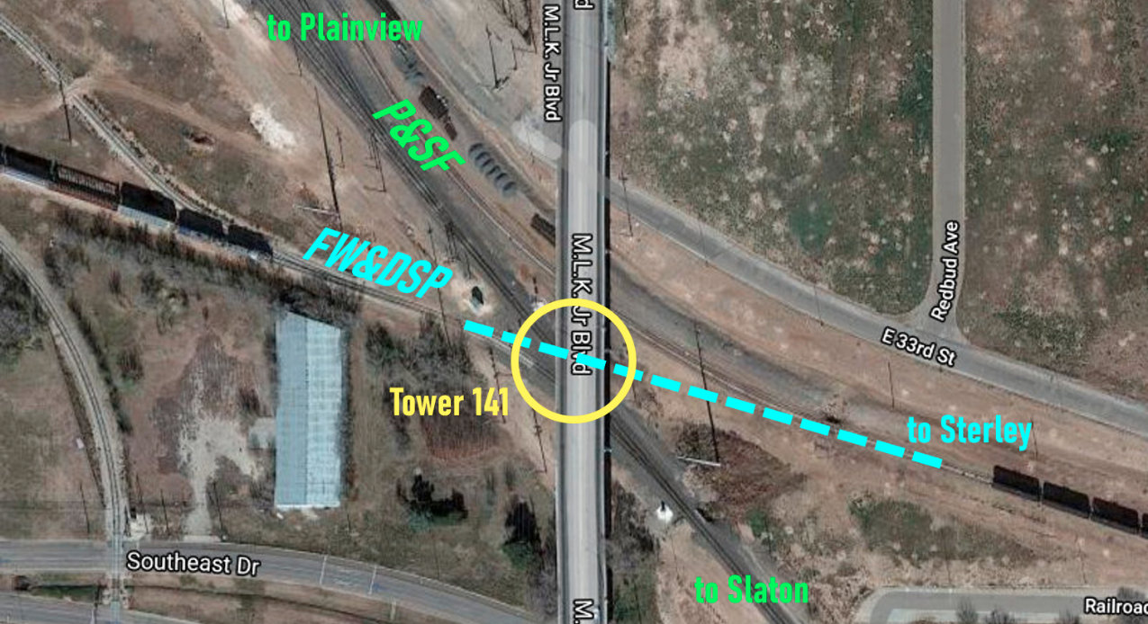
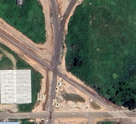
Below: This satellite view (Google Maps) shows that the
Tower 141 crossing (yellow oval) at Lubbock now sits directly beneath the M.L.K.
Jr. Blvd. overpass in southeast Lubbock. BNSF, the successor to both railroads,
elected to eliminate the crossing (blue dashes) in favor of switches onto the former P&SF
line. The FW&DSP terminated at Lubbock so its tracks to the west only went
farther into central Lubbock to serve businesses. That track is now accessed by
a switch for northbound movements off the main line from Slaton. The industry
track visible at lower left comes from that line. The FW&DSP in the opposite
direction went to Sterley, northeast of Lubbock. That track now comes directly
out of a yard area immediately northwest of the former Tower 141 crossing and
curves to the southeast. In about a half mile it curves 90 degrees to the
northeast toward Sterley, serving only industry tracks. It ends about a mile
from Tower 141 at the trestle over the North Fork of the Double Mountain Fork of
the Brazos River.
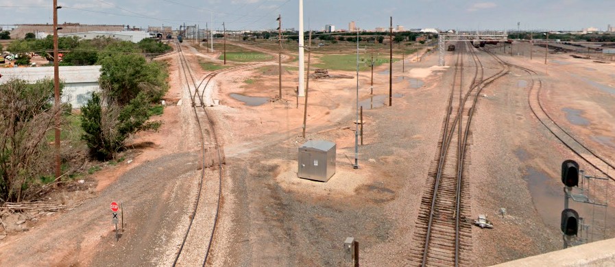 |
Left: This
Google Street View from May, 2023 was captured facing northwest from M.
L. K. Jr. Blvd. directly above the former Tower 141 crossing. At the
bottom of the image, the ex-FW&D tracks at left begin to curve south
instead of continuing straight ahead to the former diamond. The ex-P&SF
tracks at right lead into the yard which has been expanded over the
years. The extent to which the LBWR may perform switching on any of
these tracks is undetermined.
Joe McMillan's photo at top of page was taken in approximately
the same direction as this view, hence the former Great Plains Life Building is
the tall tan structure visible at top center. |
Below Left: This Google
Earth satellite view from July, 2023 shows the Tower 142 crossing. The north /
south ex-P&SF track can be seen crossing the southeast / northwest FW&D line at
a 62-
degree acute angle. Both tracks cross 9th St. (east / west street at the
bottom of the image), with the FW&D east of the P&SF. Below
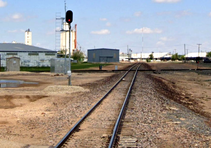
Right: This Google Street View from May, 2023 looks northwest
along the former FW&D tracks toward the Tower 142 crossing. The image was
captured from the 9th St. grade crossing. The interlocker cabin visible
trackside in the Plainview image at top of page sits along the left edge of this
image. For perspective, the red signal is approximately 225 feet from the diamond.
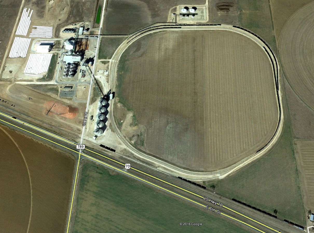
Below: About 2.5 miles
beyond the east crossing at Plainview, the ex-P&SF tracks terminate
in the lower right corner of this image adjacent to a huge White Energy Corp. ethanol plant.
The plant has a vast
rail loop for unloading grain shipments and filling tank cars with the end
product.
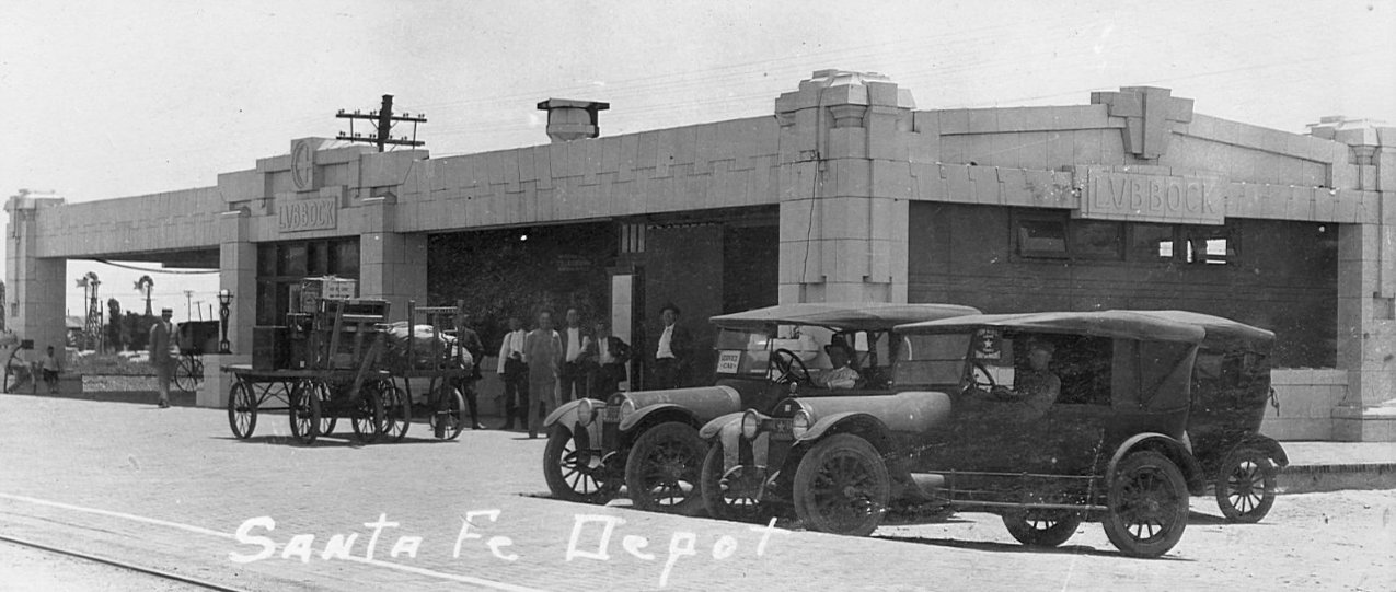
Above: Two years after Santa
Fe began operating into Lubbock, it opened this passenger depot designed by
Louis Curtiss. Curtiss also designed similar Santa Fe depots in Post, Sweetwater
and Snyder, but among the four, only the one at Post is still standing. The
Lubbock depot was replaced by a newer building in 1953, portions of which
survive as office space for BNSF. (photo,
Facebook - Historic Lubbock County)
Below:
The FW&D passenger depot in Lubbock was erected in 1928 and closed in the 1950s.
It was renovated to become part of the Buddy Holly Center in 1999. (photo,
Facebook - Historic Lubbock County)
Above: This photograph of the
Santa Fe passenger depot in Plainview was taken in 1975; by then, it was no
longer serving passengers. It remains standing, but its current use, if any, is
undetermined. It was erected in 1910, replacing a wooden depot that opened when
Santa Fe commenced passenger service to Plainview in early 1907. A photo
of Plainview's FW&D depot has not been located. (Texas Historical Commission
collection)