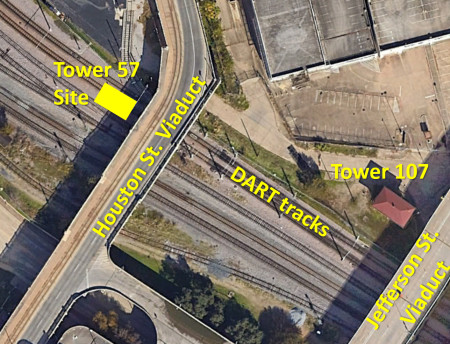
Texas Railroad History - Towers 57, 106 and 107 - Dallas
West End and Union Station
A Major Railroad
Junction at
the West End of Downtown Dallas
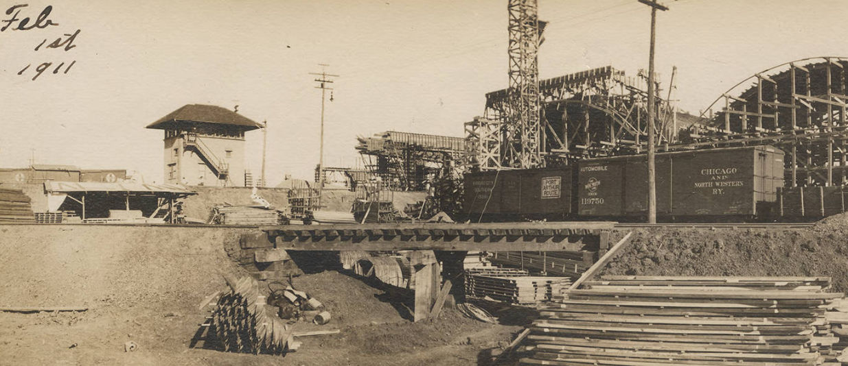
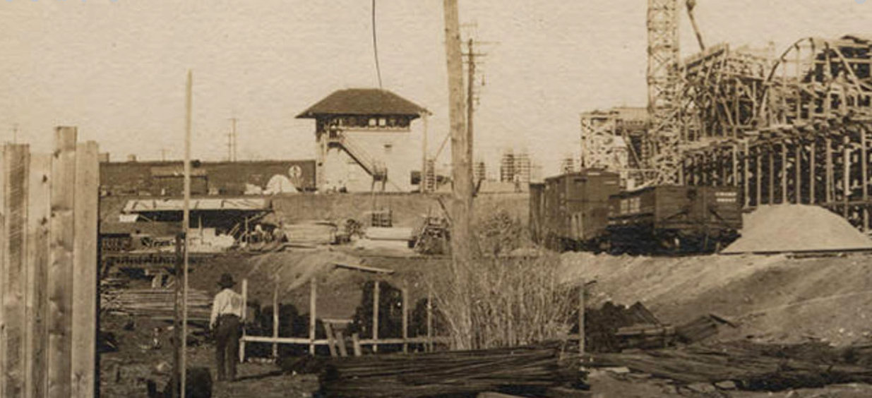
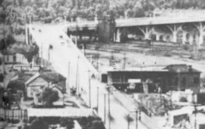
Above and Below: These two
images of Tower 57 are taken from two larger digitized photographs in
the
George W. Cook Collection maintained at DeGolyer
Library, Southern Methodist University. Both photographs face
generally east toward downtown Dallas and were taken on February 1, 1911 during
the construction of the Dallas - Oak Cliff Viaduct. From this direction, the
berm in front of the tower, which carried tracks of the Chicago, Rock Island &
Gulf Railway, blocks the full view of the tower's base. The construction of the
viaduct necessitated raising the tower so that operators could see over the
roadway to the south, but whether that effort has been completed cannot be
discerned from the photos. The viaduct crossed
over the Trinity River from downtown Dallas into the community of Oak Cliff on the
opposite bank. Boxcars belonging to the Kansas City Southern
Railway ("Port Arthur Route") and the Chicago and North Western Railway (left
and right, respectively) are visible on what appear to be temporary tracks built to
support construction.
The viaduct was built between October,
1910 and February, 1912 funded by the sale of
bonds issued by Dallas County. It is on the National Register of Historic Places as
the longest reinforced concrete highway viaduct
in the world at the time it opened (a longer one existed, used by a railroad.)
It has 51 concrete arches plus additional spans at the approaches and a steel
span over the main channel of the river. Its length varies by the criteria used
in the measurement, e.g. only the reinforced concrete sections or including
earthen fills, concrete-encased steel spans, and concrete T-beam spans. The
Texas Historical Commission claims 6,562 ft., the Historic American Engineering
Record compiled in 1996 says 5,106 ft., and the National Bridge Inventory lists
4,774 ft. Due to a horizontal clearance requirement, the segment of the viaduct
directly over the main channel of the Trinity is a 98-ft. concrete covered steel
plate girder. On the Dallas end of the viaduct, Houston Street begins parallel
to the river and rises as it proceeds south. It makes
a 47-degree turn to the southwest as it increases its elevation to reach the
proper height to cross the river. On the Oak Cliff side, the viaduct flows
onto Zang Boulevard, the namesake for a previous bridge that crossed the Trinity
nearby. The name has been changed to the Houston St. Viaduct and it has
been a one-way (westbound) thoroughfare to Oak Cliff since the opening of the
adjacent Jefferson St. Viaduct in 1973.
By the time the Railroad
Commission of Texas (RCT) began regulating grade crossings among railroads in 1902, Dallas was already a major city served by
multiple steam railways and an electric interurban. In the decades after the
first railroad entered Dallas in 1872, a mass of tracks had descended upon the
central business district, converging near the east bank of the Trinity River at
the west end of downtown. The Tower 57 interlocker was commissioned by RCT on
November 5, 1904 to manage the junction. The interlocking plant was an
electrical design with 50 functions spread over 41 levers. The Gulf, Colorado &
Santa Fe Railway, a Texas-based subsidiary of the vast Atchison, Topeka & Santa
Fe Railway, was given official responsibility for managing the design and
construction of Tower 57, which ended up closely resembling Tower 19,
another Santa Fe-designed tower less than two miles to the southeast. Santa Fe
shared the capital and recurring expenses for Tower 57 with four other
railroads: the Missouri, Kansas & Texas, the Rock Island, the Dallas Terminal
Railway and Union Depot (DTR&UD) Co., and the Northern Texas Traction Co., an
electric interurban. The DTR&UD was owned by the St. Louis Southwestern ("Cotton
Belt") Railroad, which had acquired it in 1901 for the purpose of building a downtown passenger station.
This was the
first attempt to establish a "Union Depot" for Dallas, but no other railroads
joined this effort. For the twelve months ending June 30, 1906, RCT reported an average of 412 movements through the
Tower 57 interlocking each
day, comprised of 44 "train movements" and 368 "switching movements." It was a
busy place!
 |
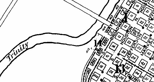
Left:
A detailed map in the 1905 Sanborn Fire Insurance Co. map set of Dallas
shows the unidentified Tower 57 (red oval) where the tracks on Water and
Broadway streets converge and cross. This was also the south end of
Houston St. where the viaduct would turn southwest in 1912. The location
of Tower 57 is well-known by the photos that show it adjacent to, and
north of, the viaduct near the turn. Jefferson Ave. is now Record St.,
and Broadway and Water streets no longer exist.
The following railroads have
been highlighted on the map as their labels are illegible at this
resolution:
The
Cotton Belt entered downtown from the north to reach the DTR&UD passenger station built in 1903. This was a branch that came off their line at Addison
between Commerce and Ft. Worth.
Santa Fe tracks from the south ran adjacent to the tower and terminated
in downtown. This was a short branch off their line between
Cleburne and Paris.
Tracks of the Missouri, Kansas & Texas (MK&T, "Katy") passed near
the tower and continued south to Hillsboro and north to Denton. At
Denton, they intersected a shared line of the Katy and the Texas &
Pacific (T&P) that ran between Whitesboro and
Ft. Worth. The T&P also
had
east/west tracks through downtown Dallas several blocks north of Tower
57.
The Rock Island tracks are visible on the berm in the photos
above. They continued north along Water St. and then turned west
to cross the Trinity and proceed to Ft. Worth.
They also went southeast to a junction with Southern Pacific (SP) south of
downtown. |
In RCT's annually published list of interlockers dated October 31, 1905, Tower 57 appears for the first
time, identified as "Dallas, Water St." It was an appropriately named
street, literally beside the east bank of the main channel of the Trinity River in downtown
Dallas. Hence, Water Street -- unpaved and mostly occupied by rails -- was inundated
anytime there was a flood on the Trinity.
Near Right: Water St.,
adjacent to the Trinity River (1899 Sanborn Fire Insurance Map of
Dallas)
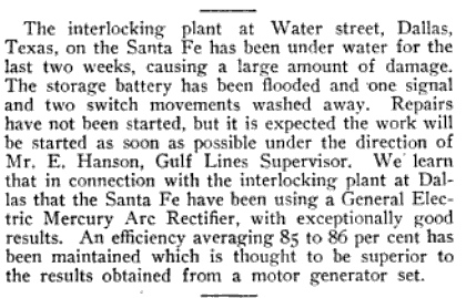
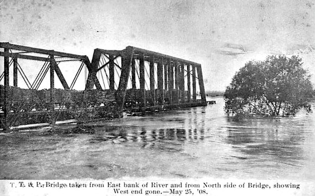
Far Right:
The Great Trinity Flood of 1908 resulted in heavy damage to Tower 57.
(The Signal Engineer, June,
1908) |
 |
 |

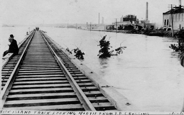
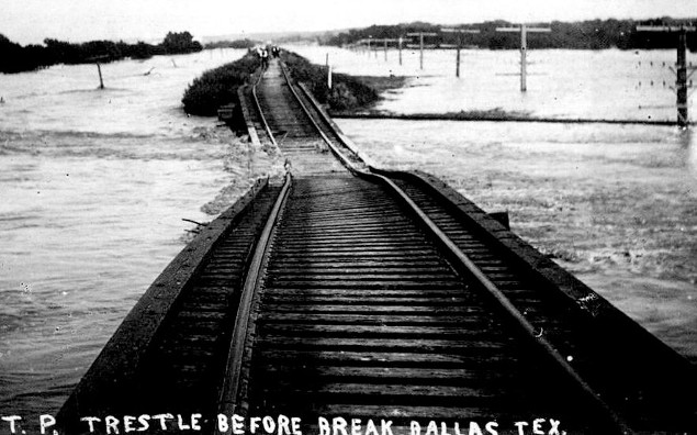
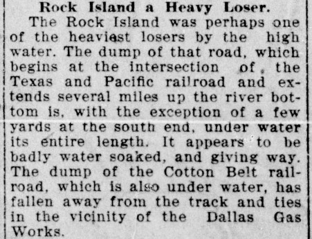
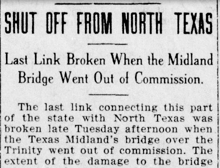
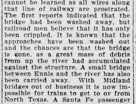
The Great Trinity
Flood of 1908 changed the course of Dallas history, providing the impetus to
reengineer many aspects of Dallas' physical infrastructure. The flood destroyed
the three public road bridges over the Trinity at Dallas, temporarily
making ferry services necessary for travel across the river. Five railroad bridges (the Rock Island, the Santa
Fe, the Southern Pacific, the Katy and the Texas & Pacific) were heavily damaged or
destroyed, and there were others that failed outside of Dallas County (e.g. the
Texas Midland bridge at Rosser -- see below.) The river was reported to be
two miles wide between downtown and West Dallas (four miles wide at Farmers
Branch, according to one newspaper report.) As Dallas' electrical power
plant (visible in the image above right)
was knocked offline, telephone and telegraph service was disrupted for several
days. The deaths of eleven people were attributed to the flood, some 4,000 people were left homeless,
and Dallas' municipal drinking water system was
rendered
inoperable. [All four photos are from the George W. Cook collection, DeGolyer
Library, SMU.]
|
|
|
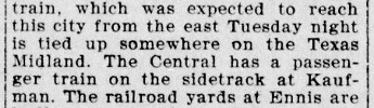

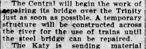
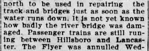
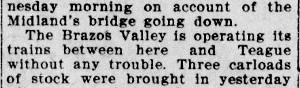
Note that
'Central' meant "Houston & Texas Central" (H&TC), a SP subsidiary. All snippets are from the
Waxahachie
Daily Light of Wednesday, May 27, 1908. |
 |
 |
 |
 |
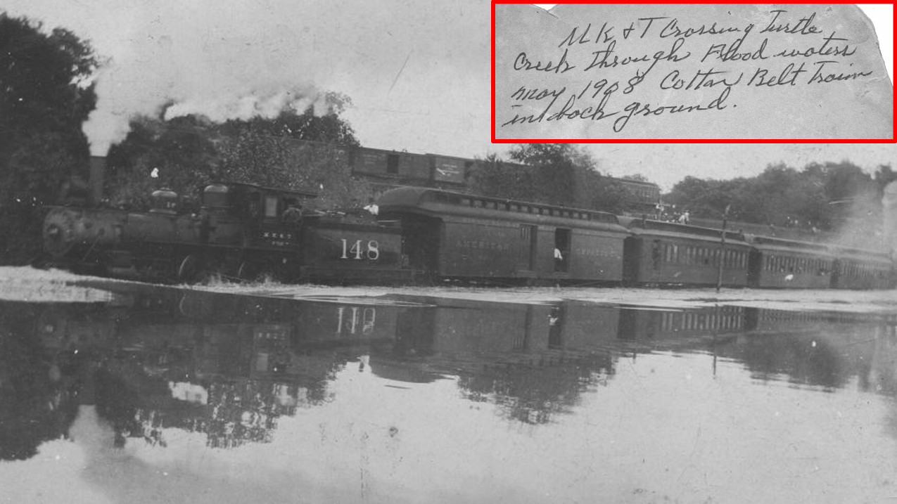
Above: Katy #148 slogs
through the Turtle Creek overflow with the Cotton Belt behind it on a higher
trestle. The creek is a tributary of the Trinity that runs through much of north
Dallas collecting a substantial amount of storm water runoff. Both of these
railroad rights-of-way have long been abandoned for other civic uses,
specifically the Dallas North Tollway (ex-Cotton Belt right-of-way reused in the
1960s) and the Katy Trail (right-of-way preserved after track abandonment in the
1990s.) (Dallas
Municipal Archives)
George Kessler moved to Dallas as a young child with
his family, arriving in 1865. A native of Germany, he went back to Europe for
university studies and then returned to the United States, becoming a renowned
city planner and landscape architect. In 1909, the Dallas Chamber of Commerce hired him to
create a comprehensive development plan for Dallas in the aftermath of the
flood. A few years earlier, Kessler had been asked to advise
on the layout of Fair Park, the fairgrounds that the City of Dallas had acquired in 1904
in an effort to revitalize and improve the State Fair of Texas. Kessler's
involvement with Fair Park had been fostered by George B. Dealey, Publisher of
the Dallas Morning News, who had observed
Kessler's work firsthand at the St. Louis World's Fair in 1904. Dealey and his
newspaper became heavily involved in promoting Kessler's work, particularly his
concept for a union passenger station to be located downtown.
Railroads figured prominently in the Kessler Plan,
including a Union Passenger
Terminal at the west end of downtown, the removal of the T&P tracks from Pacific Ave., and
a new "belt
line" track around Dallas. The belt line would facilitate rerouting
SP's north/south trains to pass east of downtown, and the T&P's
east/west trains to pass south of downtown. The belt line and the Pacific Ave.
track removal were intended to reduce train traffic through downtown, a safety
hazard that was getting worse as both the
population and the train counts increased. Much of the Kessler Plan was implemented over a long
period of time, and the plan was amended to include a levee system for the
Trinity River floodway and a re-routing of the main river channel away from downtown.
Seven neighborhoods in Oak
Cliff carry the name "Kessler" in honor of his work.
Right: (Lancaster Herald,
June 18, 1909) A new Dallas - Oak Cliff viaduct that could withstand
another Great Flood was needed quickly, so Dallas County commissioners
wasted no time in formulating a plan. Residents of the town of
Lancaster in far
southern Dallas County followed the developments closely through the
local newspaper, the Lancaster Herald.
Like Oak Cliff, Lancaster was on the "other side" of the Trinity River.
Rather than having to go northwest to Oak Cliff to cross the river,
Lancaster citizens wanted a bridge at nearby Millers Crossing (a.k.a.
Millers Ferry, the namesake for what is
now Union Pacific's Miller Yard.)
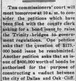
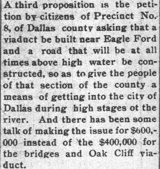
Barely a year past the Great Flood, Dallas County commissioners were
meeting for a vote to issue bonds for the viaduct and to "raise the Trinity bridges to government regulations." The
U. S. War Department had decided that the Trinity River might someday
need to be navigable for ocean-going vessels from the Gulf of Mexico
(and Dallas is still waiting for the first one to arrive), so they
required all new bridges over the Trinity River at downtown Dallas and downstream
thereof to have 90
feet of horizontal clearance and be 60 feet
above the nominal water level (the Great Flood had been measured
at 52 feet.) The bond issue was set at $600,000; many
citizens were opposed to it, convinced that the work could be done
substantially cheaper, hence there must be graft and corruption behind
it. Nonetheless, Dallas County voters approved the bond issue and the
project was completed sucessfully. |
 |
 |
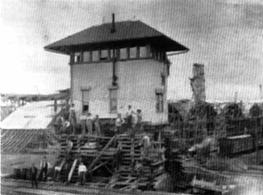
Above Left: The 1911 photos at the top of the page show
the southwest long wall of Tower 57 with the visible staircase, but this photo (from
the Layland Museum collection in Cleburne) shows the opposite long wall which faced
northeast. The June, 1908 edition of The Signal
Engineer states that the flood put Tower 57 "under water...for two
weeks" with substantial damage. This photo shows scaffolding around the base
of the tower as it was being augmented with a new structure to
raise its height so that operators would have a clear view of the rails to the south
over the finished viaduct. Whether this image shows the tower at its final
height has not been determined, but the tower is substantially elevated given that the
bottom floor would originally have been accessible from ground level.
Above Right:
This photo of Tower 57 is from
the book
Dallas
Rediscovered: A Photographic Chronicle of Urban Expansion, 1870-1925 by
William L. McDonald (Dallas Historical Society, 1978, hat tip, Bill
Bentsen.) Multiple vehicles on the roadway imply the photo was taken after
February, 1912, yet the tower appears to lack its finished roof, which is fully
intact in the other photos. The tower exterior appears dark, not the light color
in the other photos which was probably the standard Santa Fe Yellow paint scheme. Even
more mysterious, the overall shape of the tower does not appear to be identical
in both photos. The footprint of the tower in the
Dallas Rediscovered image looks to be a bit closer to a square in
contrast to
the Layland Museum photo and the 1911 photos where the long wall is at least twice as wide
as the short wall. Although the stovepipe and the middle window on
the short side provide commonality across both photos, they are the only
elements that do so. Otherwise, the towers look somewhat different.

It is not
surprising to find that the dichotomy of Tower 57's photographic appearance was
reflected in the picture postcards of the era. Offset printing presses
became commercially available c.1905, leading to an explosion of mass-produced,
color
postcards derived from photographs that were retouched and colorized by hand
before being sent to the presses. These two cards show generally the same view
of Tower 57, yet the
structures
are obviously different. The card above left
shows the black stovepipe on the northeast long wall, and under magnification, the
two windows on that wall are located the same as they are in the Layland Museum
photo. There are no windows on the new lower story that was added to raise the
tower's height. This suggests that the original source photograph showed Tower 57
as seen in the Layland Museum photo,
with the exception of a much darker exterior color.
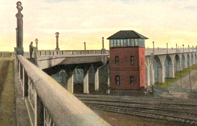
In significant contrast, the card above right
omits the stovepipe and adds symmetrically positioned windows on each floor,
similar to neither of the photos above. The outer walls are not Santa Fe
Yellow; the color could suggest a brick exterior. The roof color is different,
but the roofline is similar. The roof has no apparent protrusions, but a
stovepipe penetrating the roof on the opposite side might not be visible from
this angle. Note also that a man is standing on the viaduct at the top of a stairway;
this stairway still exists. Besides adding color, the idea behind the retouching process was to make
minor image adjustments, hence it would seem to be completely unwarranted to redraw
the tower from scratch with features that did not exist (not that the
postcard-buying public would notice or care.) The basis for the tower's visual
appearance in this postcard remains undetermined.
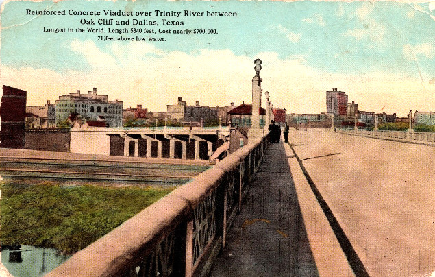
Below Left: This postcard has
a view from the viaduct that
looks back toward Dallas showing the top of the tower and a portion of its
southwest side. The staircase landing for the operations room is near the left edge of
the tower, as it was in the 1911 photos at the top of the page. Although the
window below the staircase is more obvious due the the contrast with the
exterior color, it is also present in the 1911 photos. Even with the increased height
of the tower, the width of the viaduct leaves the operators' track visibility to
the south questionable.
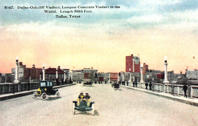
Below Right: This postcard adds little to the discussion
since only the operations floor is visible, but it does
reinforce the idea that Dallas' "world record" viaduct was a popular postcard
topic.
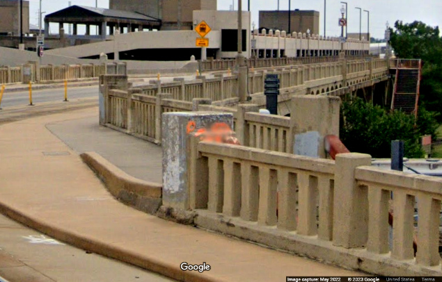
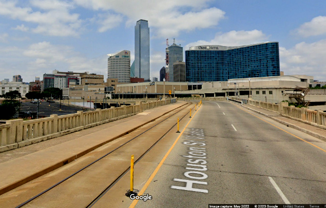
Below: These two Google Street Views from May, 2022 show
the Houston St. Viaduct near the 47-degree curve. In the southwest view (below
left), the red railing partly visible in the foreground is
attached to the staircase where the man is standing on the north side of the
viaduct (upper right postcard.) Looking northeast (below right),
the view is similar to the postcard directly above it. Note that streetcar rails
have been added to the Houston St. roadway.
Perhaps the postcard (upper right) showing a closer view of the tower with four
symmetrical windows and no stovepipe was simply the result of a retouching
process gone awry. The other three postcards are generally consistent with the
1911 photos and the Layland Museum photo. This does not explain, however, the apparent
differences in the Dallas Rediscovered
photograph. Perhaps those can be attributed to a roof replacement project,
darker paint, optical illusion and poor image quality. Other than raising its
height, no evidence has
surfaced to indicate that Tower 57 was ever rebuilt during or after the
viaduct's construction, and the timing weighs against it. The Dallas - Oak Cliff
viaduct opened in February, 1912, and one month later, the Union Terminal Co.
was chartered to build Dallas Union Terminal (as it
was originally called.)
With a plan underway by March, 1912 leading to the retirement
of Tower 57 in 1916 (an outcome that surely would have been grasped at the
outset), it seems unlikely that the tower was rebuilt in the interim.
Although execution of the union station plan began in March, 1912,
establishing the plan had been exceedingly difficult. Dallas
city and county officials, railroad executives, and local
business leaders simply could not reach agreement on where a union depot would
be located nor how it would be funded or operated. This had been a
long-festering issue dating back to the DTR&UD's initial efforts under its
charter granted in 1895. A new state law passed in 1909 authorized RCT to order
cities to build union depots when necessary for the convenience of the traveling
public, and Dallas was at the top of the list. RCT issued an order on December
2, 1909 requiring the City of Dallas to construct a union passenger terminal,
replacing five separate stations. When the City and the railroads failed to
submit a responsive plan to RCT before the deadline of May 1, 1910, RCT asked
the Texas Attorney General to file a lawsuit (but whether he actually did so is
undetermined.) Kessler's larger planning effort
for the Chamber of Commerce was already underway, so the City requested his participation in
developing a detailed plan for a union passenger terminal. A major conference of railroad executives,
government officials and local business leaders was held in Dallas on February 8,
1911, but it still took another year of meetings to create the final plan and
charter the Union Terminal Co.
To the public, the focus of the Union
Terminal Co. was the design and construction of Dallas Union Station, but the
company also had to redesign the track layout in the west end of downtown so
that all of the railroads could access the new station. Due to the location of
the T&P and Rock Island bridges over the Trinity, considerable freight traffic
would also pass Union Station (as it does so today.) This freight traffic would
increase when T&P trains were routed south of downtown in later years on the new
belt line because they still had to return to the west end of downtown to cross
the T&P bridge. Looking ahead to Dallas' long term growth and anticipated increases in train
counts, the
decision was made to replace Tower 57 with two interlocking towers to share the control responsibilities for the new track
arrangement. The buildings were
identical in architecture, and were known to the company as North Tower and
South Tower. RCT designated them Tower 106 and Tower 107, respectively, and both are still standing.
Union Terminal
Co. had also obtained a
state railroad charter so that it could build and operate tracks as necessary (and
sign trackage rights agreements) to facilitate a continuing mission to provide railcar
switching services among the eight steam railroads that comprised equal shares
of the company's ownership. These railroads were the Santa Fe,
Rock Island, Southern Pacific (through its H&TC subsidiary), Texas & Pacific, the Missouri, Kansas & Texas
("Katy"), the St. Louis San Francisco ("Frisco), the St. Louis Southwestern ("Cotton
Belt") and the Trinity & Brazos Valley. By the time Union Station
opened, the company had laid five miles of track.
 |
Left and Below: Dallas Union Station opened
officially on October 14, 1916, designed for a daily capacity of 50,000
passengers and 80 trains. As Kessler had envisioned, a small park (now Ferris Plaza, managed by the Dallas Parks & Recreation Department) was established
directly across Houston St. from Union Station to welcome arriving visitors. The interurban added a stop at the
park so that passengers could
transfer easily to and from the steam railroads. (photo, Wikimedia Commons)
 |
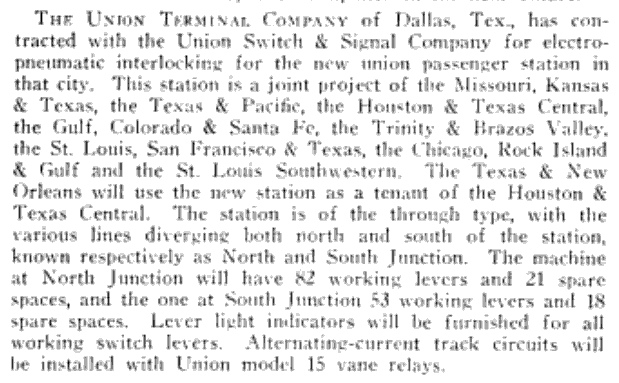 |
Left: The Railway Age
Gazette of September 10, 1915 carried this brief news item announcing
that a Union Terminal Company contract had been awarded to Union Switch & Signal
Co. for two interlocking machines to control traffic in the vicinity of
the "new union passenger station..." Union Station would open thirteen months
later. It notes that the Texas & New Orleans (T&NO) Railroad would use Union
Station as a "tenant of the Houston & Texas Central". Both T&NO and H&TC were
owned by Southern Pacific (SP). The H&TC line was the first railroad in Dallas,
passing through in 1872 building north to Denison to complete its main line from
Houston. The T&NO line ran from Dallas southeast to Beaumont via Kaufman,
Jacksonville and Lufkin. In 1927, SP would make T&NO its principal operating
company for Texas and Louisiana, leasing the H&TC and other SP railroads in
Texas to the T&NO. In 1934, this was converted to a merger; the H&TC ceased to
exist as it was consolidated into the T&NO. |

Above: Two weeks before Union
Station opened, the new interlocking design and track layout became fully
operational. A comprehensive article about the two new
interlocking towers was written by a Santa Fe signal engineer and published in the
February, 1917 edition of Railway Signal Engineer.
The article describes the interlockers as electro-pneumatic plants "...placed in service on the morning of October 1,
1916...", a rather definitive point in time. Tower 57 was officially
closed; RCT documentation at DeGolyer Library gives "August, 1916" as the
retirement date, but there was likely a transition period since the new towers
were not scheduled to begin operation until October. RCT's annual published list
of active interlockers dated December 31, 1927 changed the Tower 106
commissioning date to be April 26, 1916, but Tower 107's commissioning date
remained the same, "October, 1916" which had also been used for Tower 106 in all
previous lists. This might indicate that a review of Tower 106 records
determined that it had been approved for operation more than five months
earlier, perhaps for test purposes given the overall complexity of the design.
Tower 106 would likely have been tested first since it should have had less
control overlap with Tower 57, which was still operational in April, 1916 and
located very close to Tower 107.
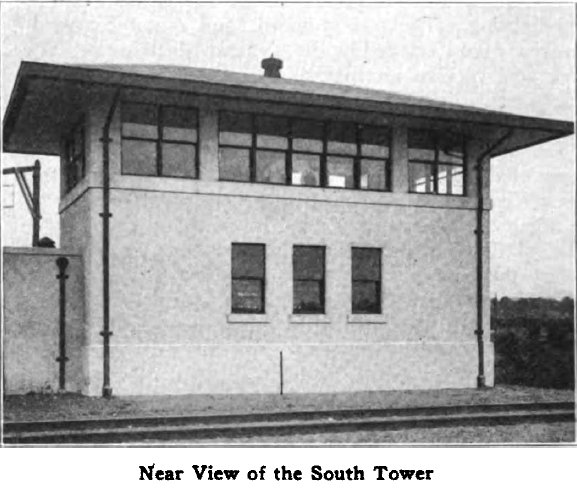
Below Left: Tower 107 as it appeared in the article;
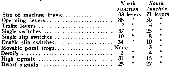
Below Right: summary of the
interlocking plants as printed in the article
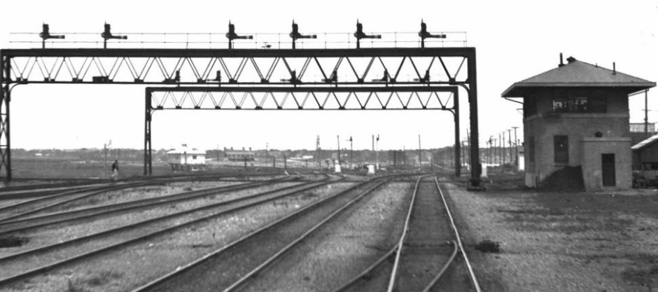
Above: Sometime in the late
1930s or early 1940s, railroad executive John W. Barriger III snapped this photo
of Tower 106 from the rear platform of his business car as his train was heading
south into Union Station. Below:
Barriger took this photo of Tower 107 as his train continued south out of Union
Station. The tower was adjacent to an interurban bridge (note overhead wires
barely visible.) The staircase in the background provides pedestrians with
access to the south side of the Houston St. Viaduct near where it makes its
47-degree turn. Were Tower 57 still standing, it would have been on the far
side of the viaduct, visible through the gap to the right
of the leftmost interurban bridge stanchion.
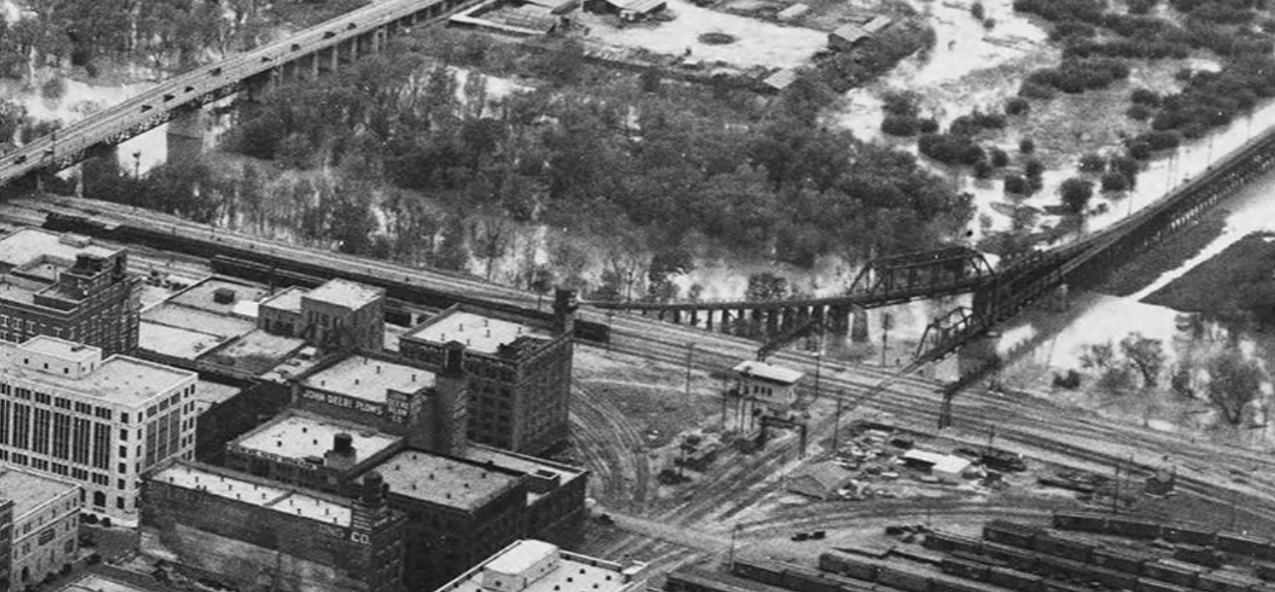
Above: The levee system for
the Trinity River proved successful in mitigating damage from Trinity River
floods; the date of this one is unknown, probably the 1940s, perhaps the major
flood of 1949. Tower 106 is prominent near the center of the image which faces
southwest. Note the curved trestle needed to carry the T&P's southwest
connecting track which led to Union Station and the Dallas Belt Line. It carried
all T&P trains except switchers since the former main line tracks on Pacific
Ave. had been relegated to industry access. The river had been straightened in
the late 1920s in conjunction with levee construction, but floods would spill
over to fill various meanders that remained in the flood plain, including the
former main channel of the Trinity River, visible here at the edge of downtown.
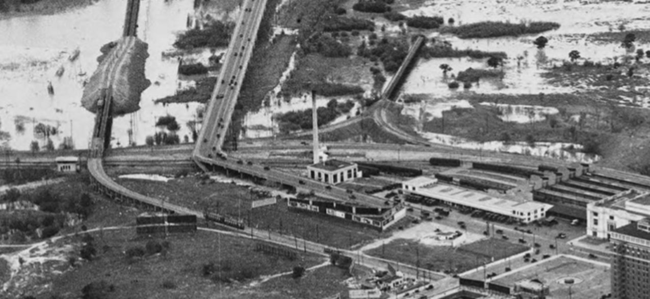
Below: This image is farther
south with a view of Tower 107 at left beside the interurban bridge -- note the
2-car interurban that is heading into downtown. Union Station is along the right
edge, and a nearby wye bridge track extends out into the floodplain. The Houston
St. Viaduct is visible carrying a steady stream of cars. (both images from a
single aerial photo by Lloyd M. Long, courtesy Foscue Map Collection, SMU
Libraries)
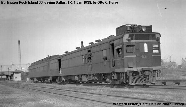 |
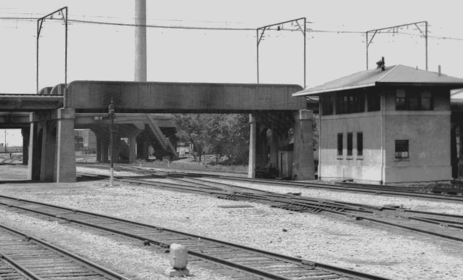
Left:
On January 1, 1938, this photo of a Burlington-Rock Island passenger
train was taken by Otto Perry shortly after the train had passed Tower
107 as it headed south to Houston. (Denver Public Library collection)
Right: Tower
107 is about 100 yards southeast of the location where Tower 57 stood. |
 |
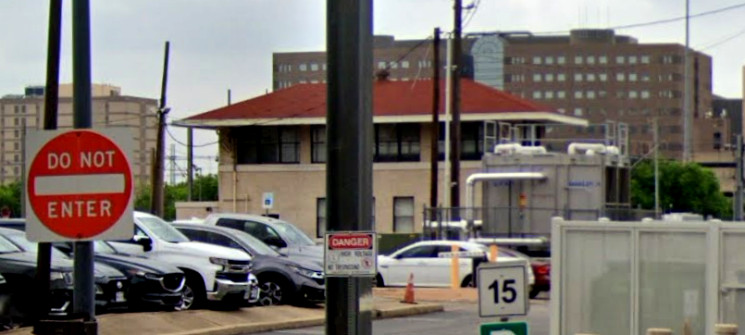
Above Left: This May, 2022 Google Street View image of Tower 106
was captured looking west-southwest from the intersection of Houston St. and Pacific Ave. While the T&P tracks
were removed from Pacific Ave. as part of the Kessler Plan, DART tracks were
added on Pacific Ave. in the 1990s so that the DART light rail system could access
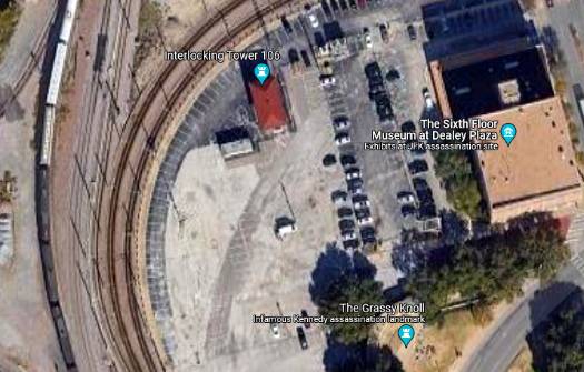
Union Station. Above Right: This Google Earth image show that Tower 106 sits in
a parking lot behind the Sixth Floor Museum at Dealey Plaza. The museum
documents the assassination of President John Kennedy in 1963. The Warren
Commission Report produced by the investigation states that an "employee of the Union Terminal Co., Lee E. Bowers,
Jr., was at work in a railroad tower about 14 feet above the tracks to the north
of the railroad bridge and northwest of the corner of Elm and Houston,
approximately 50 yards from the back of the Depository. ... In the railroad
tower, Bowers heard three shots, which sounded as though they came either from
the Depository Building or near the mouth of the Triple Underpass. Prior to
November 22, 1963, Bowers had noted the similarity of the sounds coming from the
vicinity of the Depository and those from the Triple Underpass, which he
attributed to 'a reverberation which takes place from either location.'
" Tower 106 is now owned by the Sixth Floor Musuem.
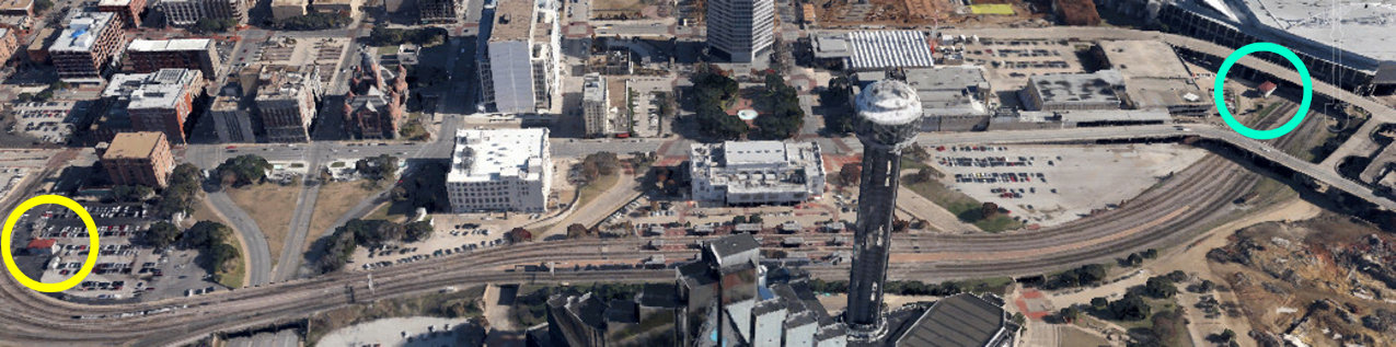
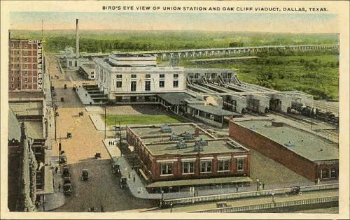
Above: This bird's eye view of
Union Station faces east, showing both Tower 106 (yellow circle) and Tower 107
(blue circle) with tracks for passenger, freight and light rail trains passing
the station and both towers. Ferris Plaza is visible as the green space east of
Union Station across Houston St. Across the tracks from Union Station, Reunion
Tower stands adjacent to the Hyatt Regency Hotel. South of Union Station, Houston St.
slowly rises and makes the 47-degree turn to the southwest onto the Houston St.
Viaduct. Tower 57 was located in the shadow beneath and along the near side of the
viaduct. Note that the tracks proceed past Tower 107, go under the Jefferson St.
Viaduct, and then ... disappear into a building?? Yes. All of the tracks pass through a
portion of the Dallas Convention Center where a DART station is located. (Google
Earth, 2013)
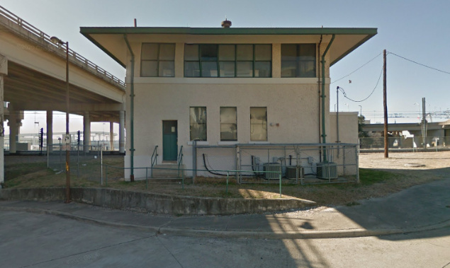
Below Left: Judging by the three air conditioning units on the
back side of Tower 107, DART may have employees as well as electronic equipment
housed in the building. Below Right:
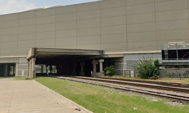
Facing northwest, the tracks enter the east side of the Dallas Convention Center
for a short (415 ft.) transition through the building toward Union Station.