Texas Railroad History - Tower 28 - Texarkana
A Crossing of the Texas & Pacific Railway and the Texarkana
& Fort Smith Railway

Above: Moments after his
business car crossed the diamond of the
Texas & Pacific
(T&P) Railway, John W. Barriger III snapped this
photo of Tower 28, capturing with it a man with a lantern walking north on the
tracks. Barriger's car, on the rear of a
Kansas City Southern (KCS)
train, was headed south in the late 1930s or early 1940s through the yard of the
International
Creosoting & Construction
Company where Tower 28 was located. (John W Barriger III
National Railroad Library)
Tower 28 was built to
control a crossing of the Texas & Pacific
(T&P) Railway and the Texarkana & Ft. Smith (T&FS) Railway on the south side of
Texarkana.
The T&P was the first to arrive, opening 74 miles of track between Texarkana and
Marshall in 1873. As part of Arthur Stilwell's plan to build from Kansas City to
a new port (Port Arthur) on the Gulf of Mexico, his railroad, the Kansas City, Pittsburg and Gulf,
acquired control of the T&FS in 1892. Stilwell amended the T&FS charter to build the Texas
portions of the route, including 24 miles of track built in 1896 from
Texarkana south to the Louisiana state line. This construction crossed the T&P at the future site of
Tower 28. In 1899, Stilwell lost control of his railroad and it was bought by
the newly chartered Kansas City Southern (KCS) Railway, which continues to
operate the route today. KCS fully merged the T&FS into its operating structure
in 1943 after obtaining
U.S. Supreme
Court approval to do so in 1934. (Texas law required railroads operating in
Texas to have their headquarters in state, which KCS did not.) Meanwhile, T&P eventually passed into ownership of the Missouri Pacific
(MP) Railroad. MP was acquired by Union Pacific Railroad, which continues to
operate these tracks today.
Tower 28 was authorized for operation on
October 20, 1903 by the Railroad Commission of Texas (RCT). At the end of 1903,
RCT published its annual report which contained the first comprehensive list of
interlocking devices in Texas. Tower 28 was listed as a 20-lever/20-function
mechanical plant built by Union Switch & Signal Co. installed at the T&P/T&FS crossing at "Sulphur".
This was undoubtedly a reference to the community of Sulphur, a small station on
the T&P located approximately five miles south of Tower 28, but the
reason for this geographic misidentification is unknown. The
location persisted as "Sulphur" until a list dated October 31, 1906
changed the location to "South of Texarkana". That table also reported that
there were 27 average daily movements past the tower during the prior year.
Twenty years later, in RCT's table dated December 31, 1926, the location was
revised to "Texarkana, 2 miles west" and the plant was listed as having 24
functions. A year later, the published table again changed the location,
this time to "West of Texarkana", and this location persisted through the final
list published on December 30, 1931. Despite RCT's revisions to the tower's
location, Tower 28 never moved!
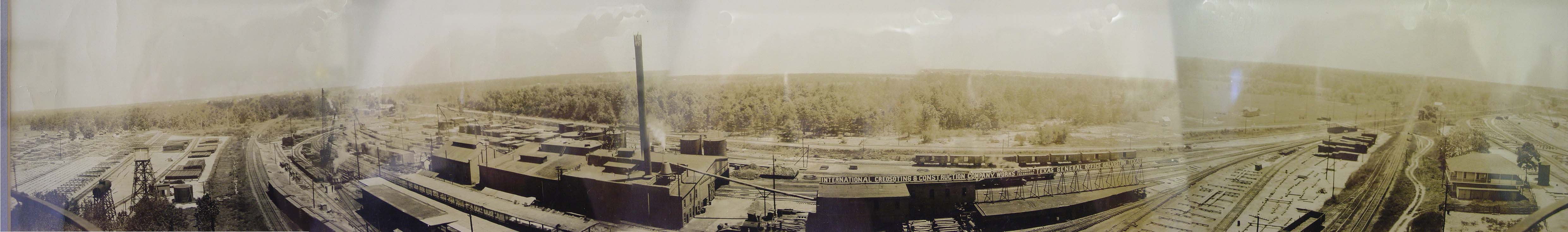
Panoramic Image, International Creosoting &
Construction Co. (click to enlarge)

Above: The crossing guarded by
Tower 28 was on the property of the International Creosoting & Construction
Company, a railroad tie manufacturing facility. The crossing is at the
intersection of the two rail lines visible on the right side of this photo.
This panorama was probably
taken from the top of the water tower that is visible in Barriger's photo.
The creosote works became owned by the Kerr-McGee Corporation and was later sold
to Tronox, Ltd.. It is now a Superfund
cleanup site due to decades of improper storage and disposal of creosoting
chemicals. (Myron
Malone collection)

Above: This snippet from the panoramic photo looks south
along the KCS showing the north side of Tower 28. Note the tree west of the
tower, which is also visible in Barriger's photo. Below:
This is an equivalent view as the image above, simulated by Google Maps
from recent satellite imagery.


Above: This snippet from the
panoramic photo above shows the KCS main line curving along the west side of the
property.
Below: This is
the same view as above, simulated by Google Maps from recent satellite imagery.

Tower 28 Site Photos (Myron Malone
photos)
 |
Left:
Looking south on the KCS main line, the concrete bunker to the left is the automatic interlocker cabinet
that replaced Tower 28's plant. The KCS tracks pass beneath the Highway 151
overpass in the distance. The old lead into the tie plant is in the foreground
and the UP main line is behind the cabin. |
Right:
The site of
Tower 28 is where the short sections of rail lay next to the weeds, but
there is no evidence of its foundation. |
 |