Texas Railroad History - Tower 192 - Fort Worth (Purina,
Dalwor & 6th St. Junctions)
A Large Wye Junction of the Chicago, Rock
Island & Gulf Railway near Downtown Ft. Worth
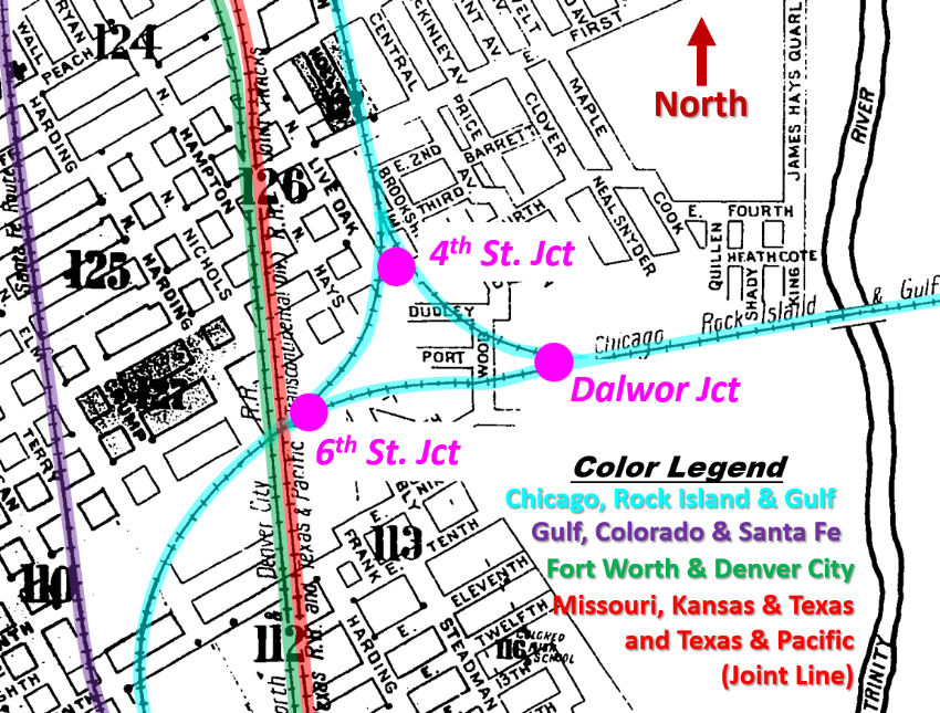 |
Left: This
index from the 1910 Sanborn Fire Insurance Co. map of Fort Worth has
been annotated to highlight three junctions of the Chicago, Rock Island &
Gulf (CRI&G) tracks controlled by the Tower 192 interlocker. The
junctions are less than a mile northeast of downtown Fort Worth
and they remain active today. The interlocker archives
of the Railroad Commission of Texas (RCT) stored at DeGolyer Library,
Southern Methodist University, have a Tower 192 folder labeled "4th St.
Jct., 6th St. Jct. and Dalwor Jct.", clearly identifying this area
as the focal point of this interlocker.
The Tower 192
interlocker was authorized for service by RCT on August 26, 1946 to
control all three junctions. It was an automatic plant with remote
controls located in the CRI&G dispatcher's office. By May, 1947, 4th St.
Junction had been renamed "Purina Junction" by Rock Island officials,
due to its proximity to a large Ralston Purina Co. plant that was a
major Rock Island customer.
Although not
readily apparent from the map, the north/south tracks immediately west
of 6th St. Junction cross over the CRI&G tracks on a bridge. When
this map was drawn, they
belonged to the Fort Worth & Denver City Railroad, and the Missouri, Kansas & Texas and Texas & Pacific railroads
(joint track.) Today they belong to
successor railroads Burlington Northern Santa Fe (BNSF) and Union
Pacific (UP), respectively. |
For compliance with Texas' railroad ownership laws, the
Chicago, Rock Island & Texas (CRI&T) Railway was chartered as a Texas-based
subsidiary of the Chicago, Rock Island & Pacific ("Rock Island") Railroad to own
tracks that were being extended south from
Oklahoma in 1892. By charter, the original target was Weatherford, 27 miles west of Fort Worth.
CRI&T rails crossed the Red River north of Ringgold and proceeded generally
south through Bowie to Bridgeport on a direct
heading to Weatherford 32 miles farther south. The line to Weatherford
was never completed; instead, the charter was amended in 1893 to authorize
construction to Fort Worth and
Dallas. The tracks out of Bridgeport went
southeast to Fort Worth, reaching there on August 1, 1893.
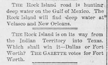 |
Left:
Cheerleading for their community (one of the prime responsibilities of
early Texas newspapers) has the Fort
Worth Gazette of March 5, 1892 speculating on the Rock
Island's plans.
Right:
By March 24th, the Fort Worth Gazette
had begun reporting on Fort Worth businesses hired to perform grading
work for the Rock Island. Bowie is about sixty miles northwest of Fort
Worth, so the Rock Island was definitely coming to Texas, but the true
destination was unknown. The newspaper comments that the route "...can't
long be kept from the public." The charter bill had already been passed
into law, but for competitive reasons, railroads didn't always specify
their true plans in the charter, preferring to amend it later
once their construction was close enough to facilitate a quick
redirection. Weatherford was the official
destination, but it's plausible that they never intended to build there. |
 |
Why was
Weatherford the initial target? In his book A History
of the Texas Railroads (St. Clair Publishing 1941), S. G. Reed, the dean
of Texas railroad historians, acknowledges the plan to build to Weatherford and
the subsequent decision to redirect the line to Fort Worth, but he has no
comment on the underlying rationale for either decision. In the early 1890s,
Fort Worth was about five or six times larger in population than Weatherford.
So, if it was legitimate,
the idea to bypass Fort Worth would need to have been based on some benefit to be
realized by reaching Weatherford (which obviously did not relate to passenger
service, given the massive disparity in population.) Two major railroad
connections were available at Weatherford: the Texas & Pacific (T&P) east/west
main line to Ft. Worth and El Paso, and a branch
line of the Gulf, Colorado & Santa Fe (GC&SF) Railway to
Cleburne from which its main line extended south to
Houston and Galveston.
Access to the Gulf coast for export of grain and other agricultural products
from states served by Rock Island was certainly a prime objective, so a
connection with the GC&SF at Weatherford would potentially have offered faster
service to Galveston as opposed to routing freight through the complex rail
network in Fort Worth (which the GC&SF main line also served.) Yet, the GC&SF
parent company, the Atchison, Topeka & Santa Fe, was a direct competitor of Rock
Island for much of the agricultural freight that would be coming from the Plains states.
It seems more likely that
Weatherford was a misdirection by Rock Island for both competitive and
land-purchase reasons, i.e. just plausible enough that competitors might believe
it. Building to Bowie and Bridgeport aligned with construction to Weatherford,
but left Rock Island close enough for a sudden redirection to Fort Worth. Fort
Worth and Dallas were too large to ignore, but announcing that plan in their
initial charter would have given other railroads a head start on countering it
(for example, by new construction on the north side of Ft. Worth to grab the
best rights-of-way.) Also, Rock Island wanted to procure land in its path to be
sold at a profit when prices rose due to the arrival of the railroad. Allowing
the entire route to be precisely and publicly known empowered the land
speculators to get there first, raising land acquisition costs.
Having reached Fort Worth, Rock
Island remained interested in building a line to the Gulf but also wanted to
serve Dallas.
In 1902, they sought
approval to build from Ft. Worth to Galveston via Dallas under the name of the
Chicago, Rock Island & Gulf (CRI&G) Railroad. The CRI&G was also authorized by
its charter (issued May 13, 1902) to absorb the other three Rock Island
subsidiaries in Texas (the CRI&T and two subsidiaries in the Texas Panhandle.)
The CRI&G tracks from Fort Worth to Dallas were laid in 1903, but it was the extension
beyond Dallas to
Houston and Galveston that created the most consternation for the other railroads in Texas.
It was considered a serious threat, and railroads conducted in-depth negotiations with Rock Island about potential arrangements
to mitigate a Rock Island takeover of Texas railroading. The International &
Great Northern (I&GN) offered to sell its recently completed line between Fort
Worth and Houston, but Rock Island wasn't interested. Southern Pacific (SP) was
particularly concerned; their Houston & Texas Central (H&TC) subsidiary had a
route from Ft. Worth to Houston (via the main line at Garrett) and was
undoubtedly carrying most (or perhaps all) of
Rock Island's loads destined for the Gulf coast. SP also learned that Rock
Island had been surveying a route between Dallas and Houston that was shorter,
with fewer curves and lower grades than the H&TC line. Other than the I&GN route
(which was poorly constructed and less direct), the sole alternative to SP from
Ft. Worth to the Gulf was Santa Fe's main line. But as direct competitors with
Rock Island in many of the areas from which these loads originated, they were
unlikely to have offered favorable rates and divisions.
Eventually, SP
and Rock Island agreed
to a massive and complex plan involving split ownership of three SP component
railroads in Texas: the H&TC, the Houston East & West Texas, which ran from
Shreveport to Houston, and a new SP subsidiary that would be created to own the
Texas & New Orleans line from Dallas to Sabine Pass via Beaumont. In addition to
owning half of each of these railroads, Rock Island would be allowed to choose the President of each railroad.
Trackage rights and other service agreements fleshed out the remainder of the
contract between SP and Rock Island, which was promptly submitted to RCT. This would have dramatically
changed the evolution of the rail network in Texas, but RCT refused to approve
the plan.
Ultimately, the CRI&G's tracks were not extended to Galveston directly.
Instead, Rock Island became a 50% owner of the Trinity & Brazos Valley
(T&BV) Railway
which eventually offered service to Houston and
Galveston from both Dallas and Ft. Worth, having built on the shorter, low grade
right-of-way that had worried SP. In a fit of spite, SP responded by building
the Mexia - Nelleva Cutoff to compete directly with the new line, paralleling
the T&BV tracks a few yards to the west for 42 miles! ... which
did not work out well for either railroad.
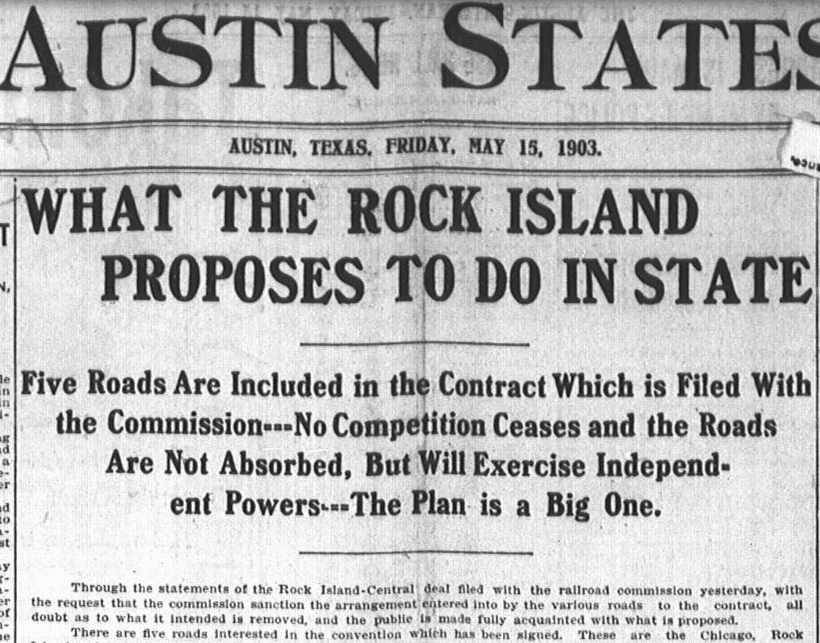
Above: The "Rock Island -
Central deal" (Central, as in "Houston & Texas Central") was front page news on
May 15, 1903 in the Austin Statesman.
The article goes on to discuss the proposed arrangement that had been submitted
to RCT the previous day. It would have radically altered railroad
development in Texas, but the Commission voted 2 - 1 against approval. Within a
year, Rock Island had adopted an aggressive plan to compete, rather than
cooperate, with SP.
Intent on starting toward the Gulf, the CRI&G
initiated construction to Dallas in 1903, departing Fort Worth from Rock Island's existing tracks between 4th St. and 6th St. The decision was
made to create a triangular junction that could also serve as a wye. This track
arrangement was in place by the end of 1903, but the junctions were not
interlocked. In 1917, the Purina feed mill was built immediately north of the
4th St. junction, eventually incorporating some existing buildings into a larger
complex. In 1930, the City of Fort Worth began construction of a lengthy
underpass to eliminate the 4th St. grade crossing of two legs of the wye.
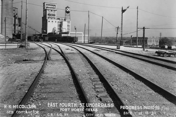
Above Left: Numerous photos of
the 4th St. underpass construction project were taken, including this one
looking back to the north toward the Purina feed mill from 4th St. Junction.
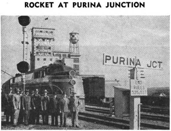
(Ft. Worth Public Library collection) Above
Right: This photo appeared in the
Rock Island Lines News Digest of May, 1947.
The accompanying article explains that to honor their major customer, Rock
Island had officially renamed 4th St. Junction to be Purina Junction. The group
is standing in front of the Twin Star Rocket passenger train (Minneapolis to
Houston via Ft. Worth) which had only been operating for slightly more than two
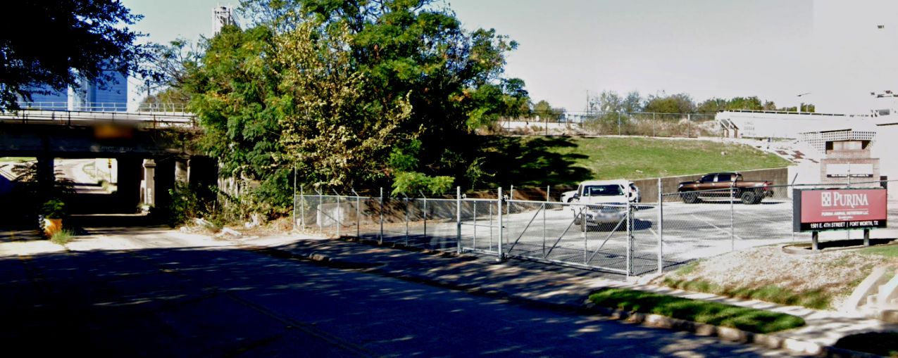
years. Below: Facing
northeast, the 4th St. entrance to the Purina mill remains adjacent to the underpass. (Google Street View,
October 2021)
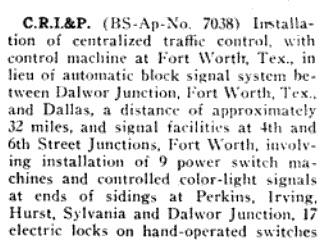 |
Left and
Right: The February, 1945 issue of
Railway Signaling
describes Rock Island's submission to the Interstate Commerce Commission
(ICC)
which proposed to improve and interlock operations at 4th St., 6th St.
and Dalwor Junctions. To some undetermined extent, one or more of these
junctions had been manned for the purpose of conveying train orders and
setting semaphore signals. The December, 1912 edition of
The Railroad Telegrapher, a
magazine produced by the telegrapher's union, mentions that a member is
currently "working extra at Dalwor Junction." The ICC approved Rock
Island's submission, and Tower 192 was authorized for operation by RCT
on August 26, 1946. |
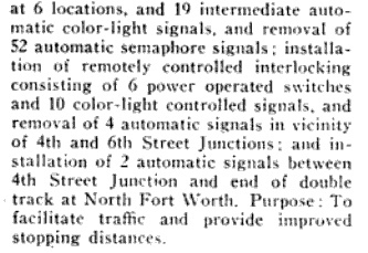 |
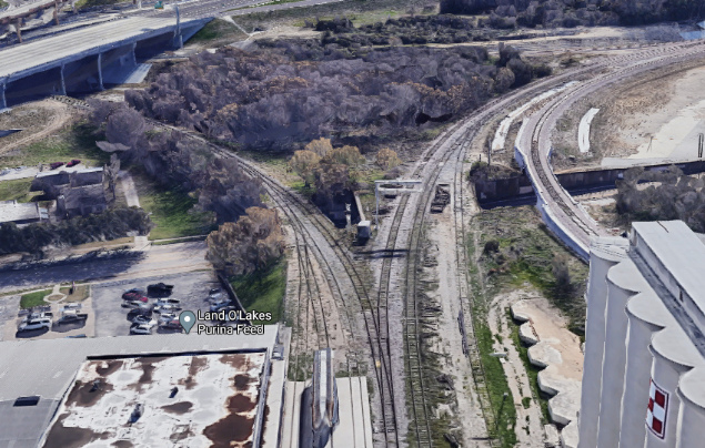
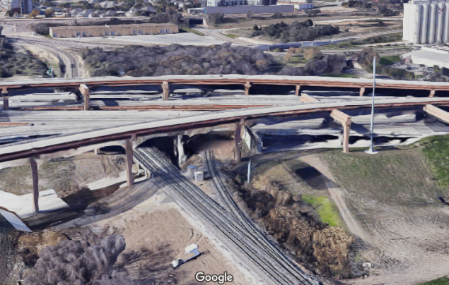
Above: satellite view of
Purina Junction and the 4th St. underpass (Google Earth)
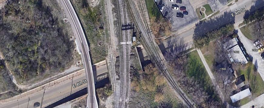
Below Left: When Rock Island
went bankrupt in 1980, signs such as this one near the Purina Junction cabin
began to pop up. (Ronnie Patterson collection)
Below Right: Eastbound on 4th St., the underpass still
shows the faint herald of the Rock Island. (Google Street View)

 Left:
In March, 1980, Rock Island went into bankruptcy and ceased operations. The
Federal Register
on June 30, 1980 published an announcement that the ICC had granted permission
for the Oklahoma, Kansas & Texas (OKT) Railroad, a new subsidiary of the
Missouri - Kansas - Texas Railroad, to operate over the Rock Island main line
between Herington, KS and Fort Worth. Rock Island tracks were gradually sold off
by the Bankruptcy Trustee.
Left:
In March, 1980, Rock Island went into bankruptcy and ceased operations. The
Federal Register
on June 30, 1980 published an announcement that the ICC had granted permission
for the Oklahoma, Kansas & Texas (OKT) Railroad, a new subsidiary of the
Missouri - Kansas - Texas Railroad, to operate over the Rock Island main line
between Herington, KS and Fort Worth. Rock Island tracks were gradually sold off
by the Bankruptcy Trustee.
All three junctions
and associated tracks that were controlled by Tower 192 remain operational
today. The former Rock Island tracks between Dallas and Fort Worth are now used
by the Trinity Railway Express to operate commuter rail service between downtown
Ft. Worth and downtown Dallas.
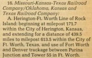
Above: current 3-D views of
Dalwor Jct. (left) and 6th St. Jct. (right)
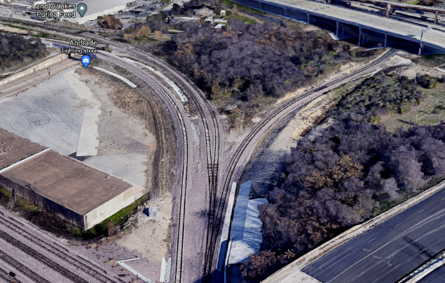
simulated by Google Maps Below Left:
current 3-D view of Purina Jct. simulated by Google Maps
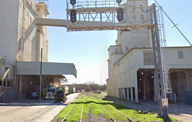
Below Right: January, 2020
Google Street View of Purina Jct. looking south from 1st. Street.