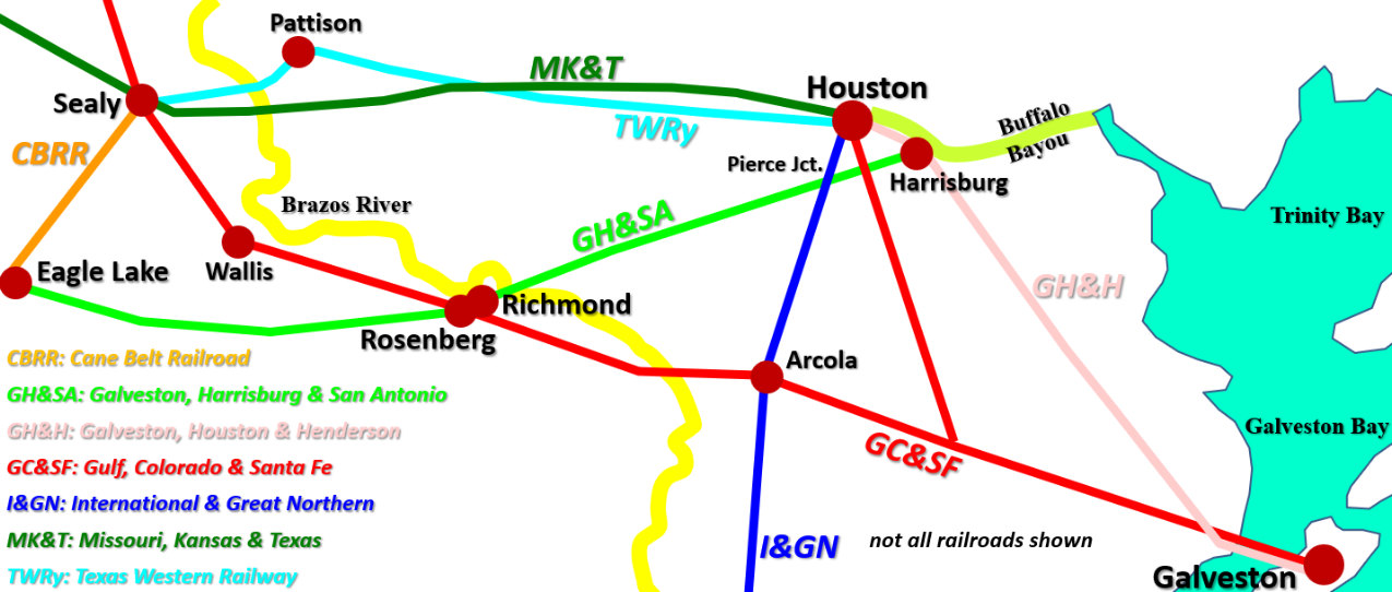
Texas Railroad History - Tower 163 - Sealy
A Crossing of the Missouri, Kansas & Texas
Railroad and the Gulf, Colorado & Santa Fe Railway
 |
Left:
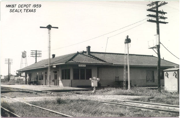
This photo of Sealy Union Depot and the Tower 163 crossing from the H. D.
Connor Collection was taken in 1959. Although the photo is labeled as "MK&T
Depot", it was a joint station used by the Gulf, Colorado & Santa Fe (GC&SF,
"Santa Fe") Railway and the Missouri - Kansas - Texas (MKT, "Katy") Railroad. It
sat in the southwest quadrant of the crossing located on the north side of the
town of Sealy, about 48 miles due west of downtown Houston. In this view, the
Katy track is crossing in front of the station, horizontally across the image.
The two tracks in the foreground, a main line and a yard track, belong to Santa Fe.
This physical track arrangement persists today, but the station is no longer
standing, removed in the 1969-70 timeframe.
As of 1959, the only Santa Fe passenger train stopping
daily at Sealy was the passenger local (Trains 5 & 6.) Santa Fe's daily California Special
passenger train conditionally stopped at Sealy, but only if there were
Brownwood (or farther west) passengers to
discharge (eastbound) or receive (westbound.) Santa Fe's Texas Chief
passenger train passed through Sealy daily but did not stop. A 1956 Katy
timetable lists one daily passenger local that stopped at
Sealy both ways (Trains 21 & 22) which presumably was still the case three years later
when this photo was taken. |
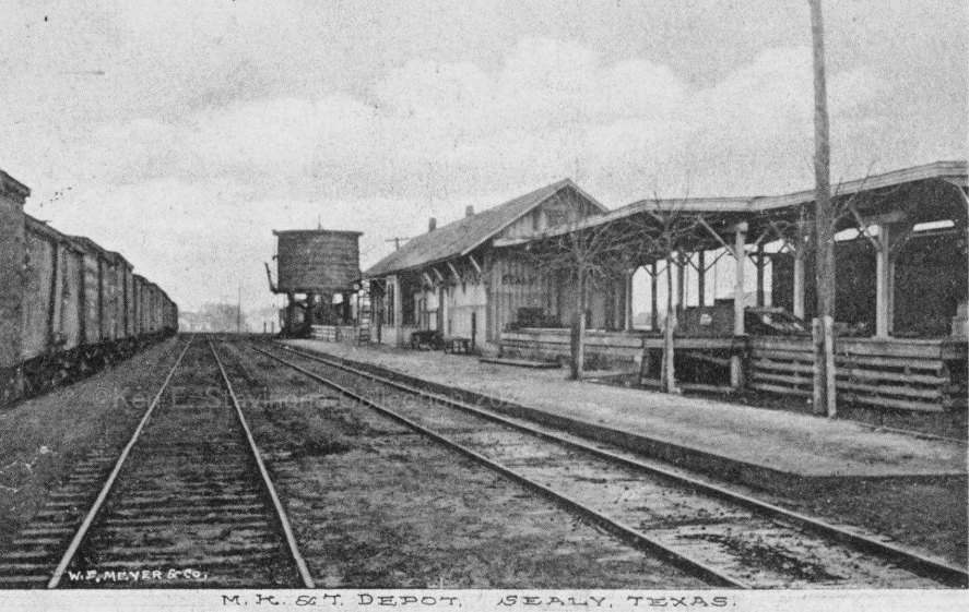
Below: undated photo of the original MK&T depot in
Sealy (Ken Stavinoha Collection)
There are many railroad towns in Texas for which the
source of the town's name is disputed by
conflicting historical
narratives. Sealy is not one of them. All sources agree that the town was,
at minimum, named for George Sealy; arguably, it was named for both George and his older
brother, John. The Sealy brothers were heavily involved in the origin,
development, ownership and management of the Gulf, Colorado & Santa Fe (GC&SF) Railway
in the early 1870s at
Galveston, Texas' largest city at the
time. Given the historic legacy of the Sealy brothers in successfully guiding the railroad
through organizational and financial difficulties, it seems odd
that Sealy is among the smaller towns in Texas named for the pioneers of the
GC&SF. Today, Rosenberg is five times larger, Temple is twelve times larger. But none
of the other pioneers had the impact of the Sealy brothers, particularly George, on the early development of the
GC&SF.
The story of the Sealy brothers begins prior to the Civil War.
John had relocated from Pennsylvania to Galveston where he helped to establish a
successful dry goods business. George followed in late 1857, just shy of his
23rd birthday. The dry goods business depended on shipping,
particularly cotton, and Galveston was already a significant Gulf port. Its wharves were run somewhat haphazardly by a mix of individuals and
small companies, and in 1854, an effort toward consolidation began. In 1858,
John Sealy became President of the enterprise that controlled the consolidated wharves.
The following year, the Galveston, Houston & Henderson (GH&H) Railroad completed its line from Galveston north to
Houston, the first railroad to serve Galveston
Island. Connecting the Port of Galveston to the
GH&H became of paramount importance, so John Sealy sought a state railroad
charter to authorize construction of tracks from the wharves to a junction with the GH&H. When the charter was granted in 1860, the name
of the company became the Galveston Wharf Co.
The city of Galveston had
previously filed a lawsuit claiming unauthorized use of city streets by the
various wharf companies, but now that the wharves were entirely under
one company, settlement negotiations ensued. In exchange for authorizing the
prior use of city streets along the wharves plus additional access for new
tracks to connect with the GH&H, the city received non-voting stock interest in
the Galveston Wharf Co. representing about one-third of the company. (The shares
were non-voting, but the city gladly deposited the regular dividends paid on the
company's stock.) As a much closer relationship evolved between the city and the
company, there were claims of preferential treatment for Galveston-based shippers to
the detriment of shippers based elsewhere. As explained by S. G. Reed in his
definitive work, A
History of the Texas Railroads (St. Clair Publishing, 1941), the
Galveston Wharf Company...
"...enjoyed a monopoly and was
accused of excessive rates for wharfage dockage and handling. It is known too
that many Houston merchants organized barge lines to handle their tonnage down
the Bayou which they transferred to ocean steamers in Galveston Harbor, this to
avoid the Galveston Wharf Co. charges."
Reed's Bayou reference was to Buffalo Bayou,
the waterway into Houston that supported shallow draft steamboats and barges.
Decades before the Houston Ship Channel would be dredged from Buffalo Bayou (in
1914),
there had been regular steamboat service between Galveston and Houston dating to
the 1830s. By 1869, the Houston Direct Navigation Co. was regularly shipping
cotton on Buffalo Bayou (and would ship nearly two million bales between 1869
and 1881.) In those post-War years, Houston's transportation hub expanded
substantially. Rails from
Houston soon extended west to Columbus (1868) and Austin (1871), north to the Red
River (1873), northeast to Longview (1873), and east to Beaumont (1866). Rails from Houston south to the Brazos River port of East Columbia
that dated from before the War
were also rehabilitated, by the International & Great Northern (I&GN)
Railroad. Although
the GH&H never extended its rails beyond Houston, it remained a critical
transportation resource, the only rail line onto Galveston Island and thus the
only way of shipping by rail in and out of Galveston's port.
Civic and business leaders in Houston complained vociferously that the Galveston
Wharf Co. monopoly (and its cozy relationship with the city of Galveston) was
resulting in preferential treatment for Galveston-based shippers and unfair charges
for shipments originating out of Houston. Houston had a potential recourse,
however, at least unofficially. Inbound freight for Galveston traveling
by rail had to pass through Houston to be switched to the GH&H. There were claims that Houston
officials would periodically declare a yellow fever quarantine of Galveston
as an excuse for interdicting cargo. Freight would be
offloaded and forwarded by barge or steamboat down Buffalo Bayou, bypassing
the Galveston Wharf Co. To whatever extent such quarantines, both real and imaginary, were
declared, it was a boon for shippers and laborers in
Houston. [Quarantines for yellow fever were a fact of life, particularly in the
South, and Galveston had experienced several deadly epidemics. The 1867 epidemic
officially killed 999 persons, about 4.5% of the island's population.] The belief that the GH&H's operations were at times being unfairly
restricted at Houston led to widespread
arguments that any new railroad out of Galveston would need to bypass Houston.
As Reed explains, Galveston's
citizens were certain that Houston was...
"...inspired less by fear of the
plague than by a desire to hamper Galveston trade, as the quarantines were
established with regularity every fall when cotton was moving and trade was
best. So the Galveston people in 1873 decided to build a railroad into the
interior which would not pass through Houston."
Discounting Reed's assertion, author Earle B. Young's
history of the early development of railroads in Galveston,
Tracks to the Sea: Galveston and Western Railroad
Development, 1866 - 1900 (Texas A&M Univ. Press, 1999), says in a
footnote that despite popular opinion at the time, the historical details do not support this idea as a true, motivating factor
for the railroad's investors.
"Some historians attribute the
origin of the Gulf, Colorado & Santa Fe to the problems caused by the quarantine
of Galveston cargoes during yellow fever epidemics and the need to bypass
Houston. Quarantine does not appear to have been a significant factor, however;
broader strategic goals appear to have motivated the founders."
Those broader, strategic goals were based on Galveston's
geography as the closest Atlantic port to the West Coast. A common refrain was
that a railroad should be built due west from Galveston to San Diego as quickly
and directly as possible. The idea that prevailed instead was that a
new Galveston railroad should go to Denver, which had connections to the West
Coast through a rail line to Cheyenne, Wyoming, a town on the recently completed Transcontinental Railroad. San Diego
or Denver, the new rail route from Galveston would be well south of Houston, eliminating the
opportunity for quarantine mischief.
The Sealys joined with other
Galveston business leaders to form a corporation to build a railroad west
from Galveston Island. They applied for a charter in the name
of the Gulf, Colorado & Santa Fe (GC&SF) Railway; the charter was granted by state law on May
28, 1873. To raise working capital, the new company immediately offered a stock
subscription with a par value of $750,000 that sold out within six months. At
the request of local officials, the law granting the company's charter had
included an unusual provision to allow the Galveston County government to
purchase stock in the railroad. It did so, to the tune of a whopping half
million dollars, to be funded by bonds issued by the County (which necessitated
voter approval; the bond vote barely
passed.) The
County's financial interest was managed by the Galveston County Commissioners
Court, which controlled a two-thirds majority of the voting stock of the GC&SF should
they choose to exercise it. Municipal governments often promised free land and
cash bonuses to lure railroads, but a county government owning controlling stock
in a railroad was unprecedented. The stockholders met in November and elected
corporate officers, among them Albert Somerville as President and George Sealy
as Treasurer. They also agreed that the County would choose eight of the
thirteen members of the company's Board of Directors; private stockholders would elect the other five. Delayed by the impact of the
Panic of 1873 (which
hit railroads particularly hard), construction did not commence until 1875 when a new
rail bridge from Galveston Island to the mainland at
Virginia Point was built (and then promptly damaged by a hurricane in
September, 1875, necessitating $25,000 in repairs.)
Reed explains that
the original route plan of the GC&SF from Virginia Point was to proceed
southwest...
...to cross the Brazos River at
Columbia in order to reach the rich territory served...by the Houston Tap and
Brazoria Railroad from Houston, thence between the San Bernard and the Brazos
Rivers to Caldwell, Cameron and Belton through
Coryell, Hamilton and Comanche Counties, and then to a connection in
Eastland County with the Texas and Pacific, which
was then building westward from Longview; thence through the Panhandle to New
Mexico and Colorado.
It was an ambitious plan, indeed, and it incurred
a major revision at the outset. From Virginia
Point, the railroad would instead proceed slightly northwest to Richmond where an existing rail line
was being extended to San Antonio by the Galveston,
Harrisburg and San Antonio (GH&SA) Railway (which despite its name, had no
immediate plans
to serve Galveston.) The GC&SF envisioned
Richmond as a valuable interchange point for
trade with San Antonio and points west. Beyond Richmond, the GC&SF would resume
the original plan to stay between the Brazos and San Bernard
Rivers which converge to a separation of slightly under four miles at the
narrowest point.
 GC&SF construction
from Galveston toward Richmond was slow; only
the first 42 miles to Arcola
was complete by 1877. But having finally reached somewhere, Arcola was
promoted as a significant milestone for the GC&SF because it was also a stop on
the I&GN line out of Houston that went south to East Columbia.
At Pierce Junction, about a dozen miles north of Arcola, the I&GN
tracks
crossed the GH&SA's line to Richmond (which had its starting point eight
miles to the east at
Harrisburg, a small port on Buffalo Bayou southeast
of downtown Houston.) To advertise its progress (as if reaching Arcola could be
counted as such!), the GC&SF ran a VIP excursion train from Galveston to
Richmond via Arcola and Pierce Junction.
GC&SF construction
from Galveston toward Richmond was slow; only
the first 42 miles to Arcola
was complete by 1877. But having finally reached somewhere, Arcola was
promoted as a significant milestone for the GC&SF because it was also a stop on
the I&GN line out of Houston that went south to East Columbia.
At Pierce Junction, about a dozen miles north of Arcola, the I&GN
tracks
crossed the GH&SA's line to Richmond (which had its starting point eight
miles to the east at
Harrisburg, a small port on Buffalo Bayou southeast
of downtown Houston.) To advertise its progress (as if reaching Arcola could be
counted as such!), the GC&SF ran a VIP excursion train from Galveston to
Richmond via Arcola and Pierce Junction.
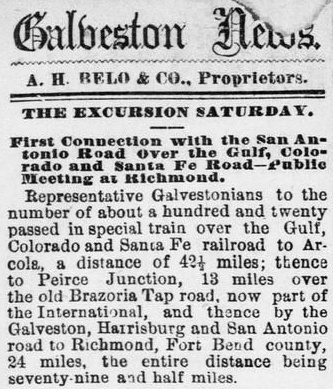
Right:
The lead story in the Galveston Daily News
of April 30, 1878 reported on the first excursion train from Galveston to
Richmond via Arcola and Pierce Junction. Note the article's spelling of
"Peirce", which wasn't technically correct (it had been changed to the common
spelling by the Post Office two years earlier), but was respected insofar as it
was the spelling used by Thomas Peirce, a businessman and landowner for whom the
community was named. Peirce had been the leader of an investor group that acquired
the Buffalo Bayou, Brazos & Colorado (BBB&C) Railroad. The BBB&C had built from
Harrisburg through Richmond to the Colorado River prior to the Civil War, but
soon fell into bankruptcy and its construction contractor ended up owning it as a judgment for
non-payment. The investors bought the BBB&C from the contractor, changed its
name to the GH&SA, and then Peirce bought out
most of the other investors. He was the driving force behind the extension of the GH&SA
to San Antonio and El Paso, and he arranged its acquisition by Southern Pacific
(SP). To promote the line he was building west to San Antonio, Peirce coined the term "Sunset
Route" sometime around 1874, a name that remains familiar to every
railroader today, nearly 150 years later.
In the summer of 1877, the GC&SF was beset by financial
intrigue that became public when a lengthy, anonymous Letter to the Editor was published by
the Galveston Daily News lambasting GC&SF
management for poor decision-making. The author (identified only as Citizen) concluded that having built no
farther than Arcola in four years was simply inexcusable, clearly evidence of poor judgment (if
not outright malfeasance) on the part of the Directors. The letter also
criticized the Galveston County Commissioners for failing to oversee GC&SF
management and exercise control as necessary for the benefit of the "public
interest." The letter carried a prescient implication that management might be allowing the
GC&SF
to drift toward financial ruin so that its Directors could buy the company out
of bankruptcy at a cheap price, leaving the Commissioners Court and the other private
stockholders with nothing. Galveston County Judge William H. Williams (as head of the
Commissioners Court) responded through a newspaper interview the next day to
assure the public that the Court was very much involved in overseeing GC&SF management.
To support his point, Williams revealed that a contractor's proposal for construction of the next five miles
of track (from Arcola to the Brazos River) had been received by GC&SF management,
but it
had also been presented independently to the Commissioners Court. The
Commissioners viewed it as a serious proposal and voted to inform GC&SF management that the proposal should be accepted. GC&SF management viewed it as
a completely unserious offer.
The following day, the current GC&SF President, well-known Galveston banker
Henry Rosenberg,
responded with an interview and rejected all of the criticism from both the
letter writer and Judge Williams. This was the first
indication of open conflict between the GC&SF and its controlling stockholder. Subsequent publication of excerpts from the diary
of General Braxton Bragg, a military veteran and former Chief Engineer for the
GC&SF (who had died the previous year), made the situation substantially worse.
Bragg's diary entries were extremely critical of GC&SF management and their decision-making
during his employment, playing into the narrative that
the railroad was doomed to fail (perhaps intentionally...?) Bragg specifically took issue with management's decision to
build the Galveston Bay bridge on the north side of the GH&H bridge,
knowing that the counter-clockwise rotation of an approaching hurricane would
result in the GC&SF bridge bearing the brunt of the storm surge (which had
proven true soon after the bridge was completed; ironically, the repairs on the GC&SF bridge
after the 1875 hurricane improved the structure such that it was the only
bridge to Galveston that survived the
Great Hurricane
of 1900 -- it thus played a critical role in the rebuilding of Galveston Island.)
 At the end of 1877, the conflict between the Commissioners Court and GC&SF management
came to a head, but a compromise was reached on the election of company Officers and
Directors. The new President, replacing Rosenberg,
was Moritz Kopperl, a Moravian immigrant who was a well-known Galveston banker,
businessman, former city councilman and member of the Texas Legislature. George
Sealy remained Treasurer. With leadership issues resolved, the GC&SF attempted
to sell $200,000 in bonds in early 1878 to finance initial construction west of
Arcola (including the Brazos River bridge.) Despite the results of the bond sale
being less than expected and not fully subscribed, the railroad proceeded to
award a construction contract since there was a looming deadline to be met. The GC&SF
charter required completion of track-laying to milepost 80 (forty miles beyond
Arcola) by November 28, 1878, less than eleven months away. Failure to
accomplish this milestone could, in theory, result in the charter being revoked.
At minimum, it would give the Galveston County Commissioners an obvious excuse
to purge GC&SF management.
At the end of 1877, the conflict between the Commissioners Court and GC&SF management
came to a head, but a compromise was reached on the election of company Officers and
Directors. The new President, replacing Rosenberg,
was Moritz Kopperl, a Moravian immigrant who was a well-known Galveston banker,
businessman, former city councilman and member of the Texas Legislature. George
Sealy remained Treasurer. With leadership issues resolved, the GC&SF attempted
to sell $200,000 in bonds in early 1878 to finance initial construction west of
Arcola (including the Brazos River bridge.) Despite the results of the bond sale
being less than expected and not fully subscribed, the railroad proceeded to
award a construction contract since there was a looming deadline to be met. The GC&SF
charter required completion of track-laying to milepost 80 (forty miles beyond
Arcola) by November 28, 1878, less than eleven months away. Failure to
accomplish this milestone could, in theory, result in the charter being revoked.
At minimum, it would give the Galveston County Commissioners an obvious excuse
to purge GC&SF management.
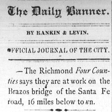
Left: The Brenham Daily
Banner, May 8, 1878, quoted an article from the
Richmond Four Counties newspaper
stating that the GC&SF had begun Brazos River bridge construction in early May.
This was the week following the VIP excursion to Richmond via Arcola and Pierce
Junction.
By October, 1878, cash reserves had reached a critical
point. GC&SF management decided to take out a loan of $250,000 to be selected
from competitive bids submitted by banks and other
financial institutions. The loan was obviously needed, but it was well understood that potential
bidders would be spooked by the fact that a government entity, Galveston County, was
the majority stockholder. Potential legal issues in the event of default made
such a loan risky (which had likewise impacted the bond sale earlier that year.)
The major problem was that Galveston County's majority ownership of the company
raised novel questions for investors assessing what would happen if the
railroad defaulted on loan or bond payments. Suing the majority stockholder for
recovery (a common legal tactic) would be impossible since the State of Texas
had sovereign immunity in
both state and Federal courts, and Galveston County was a political subdivision
of the state. The end result was that major banks and lending institutions shied away
from buying the company's bonds or issuing direct loans. When the day came to open the bids, there was only one,
submitted by GC&SF Treasurer George Sealy! Sealy had formed a private syndicate of Galveston businessmen
(including other GC&SF Officers and Directors)
willing to loan the railroad $250,000 for 90 days at 12% interest. A key
provision of the offer was that the loan be secured by a
Deed of Trust for the GC&SF's assets to be overseen by an independent Trustee.
The railroad was not close to meeting the
80-mile charter requirement, but the Commissioners were in no position to force
the company to start over with new management. They decided to back Sealy's
proposed loan, mainly because it kept the railroad alive under a management team
that was clearly supportive of Galveston's goals. There were
legitimate concerns that if the GC&SF went bankrupt, its assets would be bought
out of bankruptcy by individuals working for competing railroads intent
on disbanding the entire enterprise. With the County on board, the loan was
formally approved by GC&SF stockholders. Sealy's syndicate was now in
charge, both as Directors and debt-holders, and they quickly offered to buy Galveston
County's stockholdings in the company. The Commissioners understood that it would be
best for the railroad that future financing not
be hamstrung by the County's stock ownership. But due to the special charter provision
that granted the County the right to buy stock, there was concern that selling
it might violate the charter; hence, a
modification of the charter was deemed necessary. When
the charter law was updated by the Legislature and signed by the Governor two months later, it included a requirement that the
purchaser of the County's stock provide a $200,000 bond guaranteeing completion
of tracks into Belton (in those days, the major town between Waco and Austin) within four years.
It also revised the target date for reaching milepost 80 to be March 1, 1880, a
year away. Despite the loan, the GC&SF made little progress on the Brazos
bridge. Most likely, a significant portion of the funding was used to pay outstanding construction
bills incurred to build the grade on the west side of the Brazos
while waiting for the bridge to be completed.
On March 14, 1879, the Galveston County Commissioners met to discuss selling the
stock; Sealy's syndicate had offered $10,000 to buy it. The Commissioners voted to make the sale -- again, because it kept control of
the railroad in the hands of Galveston businessmen supportive of the enterprise. The
County had
little choice since selling the stock on a competitive basis might result in
another railroad (or even worse, the City of Houston!) buying it and then using
the newly acquired majority control to disband the GC&SF or otherwise
redirect its development in a way that would be detrimental to Galveston County.
After the sale, the County no longer owned stock in the GC&SF, but the original $500,000 in
bonds still had to be paid off by
Galveston taxpayers!
Two days later,
the 90-day loan from the Sealy syndicate was due and the railroad had
insufficient funds to make its required payment. The Trustee immediately
declared the railroad in default and announced that it would be sold at auction
at the Galveston County Courthouse on April 15, 1879, with the sale's proceeds going toward repayment of the loan. When
that day came, there were only two bidders, one of whom was George Sealy
representing the syndicate. Sealy won the auction at $200,000 and on April 17,
1879, complete ownership of the GC&SF's assets officially passed into the hands of the
syndicate. Since the syndicate owned two-thirds of the outstanding shares of the
GC&SF and most of its members were also private stockholders, the syndicate had
effectively bought the railroad from itself, with the remaining private
stockholders getting nothing. (Citizen was right!)
No longer encumbered by the previous stockholders or the County, the syndicate organized a Board of Directors from its participants
and the Board elected John Sealy to be President of the new
GC&SF corporation. The company was then able to sell $540,000 in mortgage bonds to
finance additional construction. Six months later, when illness befell John Sealy, the Board
elected George as President in October, 1879 to replace his older brother. John
eventually regained his health and became General Manager of the railroad, a
position he held until his death in August, 1884. George joined with John's widow
to build the
John Sealy Hospital in Galveston in 1890 using money John had designated in
his estate to
be used for a public charity.
 |
 |
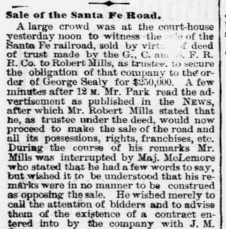
Left: The
Galveston Daily News of April 16,
1879 carried an article describing the courthouse sale of the GC&SF the previous day. The Trustee, Robert Mills, was in
charge, and he told his associate ("Mr. Park") to "cry the sale" to
kick off the auction. Besides George Sealy, the other bidder was A. J.
Walker. It is undetermined but certainly plausible that this was the same A.
J. Walker who was a Director of the Galveston City Railroad Co., the
streetcar company on Galveston Island.
The GC&SF had finally
achieved clarity in its financial situation and management. Yet, by the time the sale had occurred, nearly a year had
elapsed since work on the Brazos River bridge had commenced, and there
was little progress to report. The bridge became the highest priority activity since service to Richmond would generate
badly needed cash flow.
And because grading had proceeded beyond Richmond, additional towns
could be reached quickly thereafter. |
Above Left and Center: The Galveston
Daily News
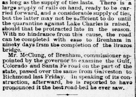
of September 9, 1879 reported that the Brazos River bridge
would be finished "in thirty days" by which time grading would be complete to
Brenham. The supply of rails to reach Brenham was adequate, but ties
were a potential concern due to a "quarantine against Lake
Charles", a sawmill town in Louisiana.
The bridge's ironwork was most probably being
unloaded at the Port of Galveston; the article doesn't say. During periods of high water, the Brazos was
navigable by steamboat as far north as the GH&SA bridge in Richmond (but no
farther; the low height of that bridge made it an insurmountable obstacle for
steamboats.) The
GC&SF bridge site was about sixteen miles southeast of Richmond. Had
the ironwork been unloaded at the bridge site, presumably such a novelty would have
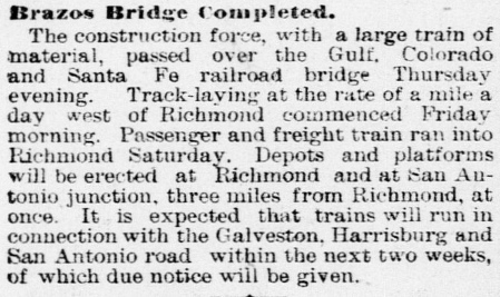
been noted in the article. Above Right:
The Galveston Daily News
of October 18, 1879 reported the Brazos bridge had opened for work trains
carrying construction materials westward. Some of these materials would be used to build
"Depots and platforms...at Richmond and at San Antonio Junction, three miles
from Richmond..." San Antonio Junction was the location where the GC&SF
would cross the GH&SA to continue northwest.
In their initial route survey, the GC&SF had expected to serve downtown Richmond, likely sharing the
GH&SA depot for the convenience of connecting passengers. Coming out of
downtown, they planned a route that went west along the south side of the GH&SA
right-of-way (ROW). Three miles out of Richmond, the GC&SF would cross over the
GH&SA tracks and curve to the northwest toward Brenham.
This crossing, called San Antonio Junction for planning purposes, would also
host interchange tracks between the railroads. The major problem that remained
to be solved was actually getting a surveyed ROW into downtown. Richmond was on the
west bank of the Brazos and sat mostly south of the GH&SA ROW. The GC&SF's
Brazos River bridge was sixteen miles southeast of Richmond, hence they
were
approaching from the southeast. Getting into downtown would
require a ROW through the heart of Richmond.
The
GC&SF reportedly asked the city to provide the ROW, but city officials
declined. Perhaps it was due to the numerous residences and businesses that
would need to be bought out or condemned, an expensive and time-consuming
process. Or perhaps they were sufficiently satisfied with the rail service
they'd known for more than two decades that they didn't sense an urgency for the
GC&SF to serve downtown. Whatever the case, without a route
into downtown, the GC&SF had little choice but to pass south and west of Richmond,
approaching the GH&SA ROW nearly a mile west of the GH&SA's Richmond depot,
and just
over two miles east of San Antonio Junction. [The railroads
might have considered adding a "depot track" to downtown, or perhaps a
connecting track to the GH&SA, either of which would have facilitated GC&SF
passenger trains going east to the depot and then backing out to return to the
GC&SF main line. No evidence has surfaced to indicate such an idea was ever
considered, which undoubtedly had its own set of issues.] The end result was
that the depot the GC&SF built to serve Richmond was a mile distant by city
streets from the GH&SA depot.
Foreseeing the difficulty for passengers to change trains at Richmond,
the railroads decided to establish scheduled connections at San Antonio
Junction where they had already agreed to have interchange tracks. Sharing a depot
there for connecting passengers allowed the railroads to help promote (and profit
from) the expected flow of passengers between Texas' two
largest cities, Galveston and San Antonio. Passengers originating or terminating
their trips at Richmond would simply use the depots in town. Before service began, the GC&SF renamed the crossing "Rosenberg Junction", in honor of former
GC&SF President Henry Rosenberg, a member of George Sealy's syndicate. This
might simply have been a case of one-upsmanship in response to Richmond, but it
is apparent that the GC&SF wanted a town to flourish at the junction. Why else
name an isolated rail junction on the prairie three miles
out of Richmond for a key member of
the GC&SF management team, and do so before the first train ever ran? People began to settle in the vicinity of the
crossing, and by 1881, a Post Office had opened. The town's layout and
construction commenced in earnest in 1883 when the GC&SF bought 200 acres of
land adjacent to the crossing, much of it to the north between the tracks and
the river. At some point, "Junction" was dropped and the community simply became
Rosenberg.
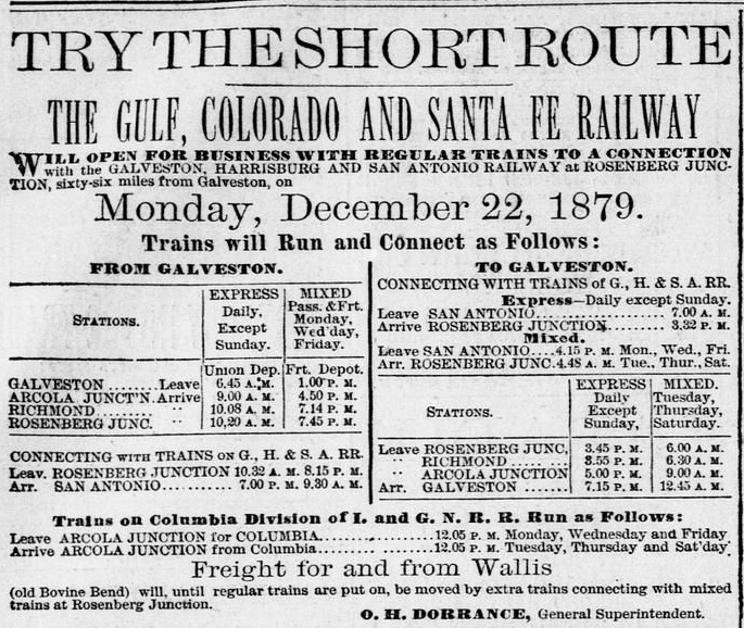 Right:
The
Galveston Daily News
of December
21, 1879 carried this advertisement announcing GC&SF scheduled passenger service
to Richmond and Rosenberg Junction commencing the next day. Note the connections
for San Antonio via GH&SA trains at Rosenberg Junction, and the connections for
Columbia via I&GN trains at Arcola Junction.
Right:
The
Galveston Daily News
of December
21, 1879 carried this advertisement announcing GC&SF scheduled passenger service
to Richmond and Rosenberg Junction commencing the next day. Note the connections
for San Antonio via GH&SA trains at Rosenberg Junction, and the connections for
Columbia via I&GN trains at Arcola Junction.
The ad mentions "Freight for and from
Wallis" to move by extra trains at Rosenberg. Wallis was the next town,
about sixteen miles northwest, in the narrow corridor between the Brazos and San
Bernard Rivers that had been identified by the route planners early on. It was named for GC&SF Director J. E. Wallis, who was also a member of Sealy's syndicate. As the ad makes clear, by the date of initial service to Rosenberg, tracks were already in service to Wallis for work trains. There was
an existing community there ("Bovine
Bend") with sufficient commerce potential that the GC&SF decided to show it as a viable service
point, even if not yet by regular trains.
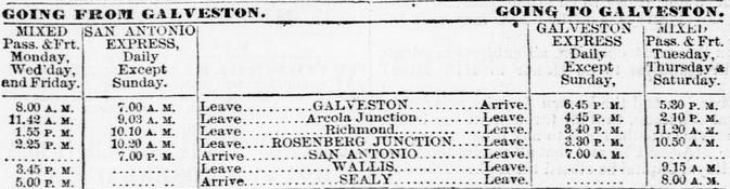
Below: Passenger service to Wallis and
Sealy, the next town farther north, commenced
January 16, 1880, less than a month after initial service to Richmond and
Rosenberg. This schedule in the
Galveston Daily News of January 15th
shows the GC&SF had begun using "Galveston Express" and "San
Antonio Express" to name its connecting service with the GH&SA.
Beyond Wallis, a dozen miles to the northwest, the GC&SF had purchased
land from the San Felipe de Austin Town Corporation for a planned community, rail yard and maintenance facility. San Felipe had been an important settlement
on the west bank of the Brazos River in early Texas history (the unofficial capital of Texas
pioneer Stephen F. Austin's colony in the 1820s), but it had dwindled
substantially by the 1870s. Its leaders declined the GC&SF's offer to route tracks through
the town, preferring instead to sell land to the railroad
from their holdings west of San Felipe. [The Texas Historical Commission (THC) says the
sale was 11,635 acres in 1879, but an article in the
Handbook of Texas claims it was three leagues (13,275 acres) sold in
1875.] The track-laying crew passed through this purchased land in December,
1879 and the railroad named the new town Sealy, in honor of George Sealy, and
perhaps his brother John, who had stepped down as President two months earlier. A Post
Office was granted at Sealy later that year, and the town quickly became a shipping point for local farmers and ranchers
while the population grew from commerce generated by the railroad and its
employees. A historical marker erected in Sealy in 1991 by THC states "...Sealy was the site of a roundhouse, wooden turntable,
and machine shops. By August 1880 two passenger trains and two freight trains
passed through the town daily."
In 1881, Daniel Haynes, a Sealy
resident and cotton gin builder, began making mattresses from compressed cotton
for his friends and family. He later patented a machine for compressing cotton
that he licensed to manufacturers around the country to use with the
catch-phrase "Mattress from Sealy". In 1906, Haynes sold his patent to a company
that adopted the trade name "Sealy", which became a well-known mattress brand
that continues today. Haynes subsequently opened the Haynes Mattress Factory in
Sealy in 1909, and it remained in operation until 1976 (and, ironically, never
made Sealy brand mattresses.) The building
remains standing as a Texas historical landmark.
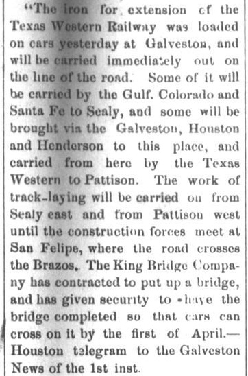
Two years after the tracks were
built through
Sealy, another railroad entered the scene. The Texas Western Railway
(TWRy), a narrow-gauge line from Houston, had reached Pattison, ten miles east
of Sealy, in 1877. After a delay of five years, capital had been raised to
extend the tracks to Sealy which required crossing the Brazos River. Work
teams commenced at both Pattison and Sealy in March, 1882 to build toward the
new bridge under construction. The bridge work took most of the year, and on December 7, 1882, the
GC&SF added "at SEALY with Texas Western Railway" to the list
of connections in its operating schedule. It was easy for
passengers to change trains at Sealy, but transferring freight was time-consuming since the Texas Western was narrow gauge. Railcars could not be
transferred directly, so freight had to be offloaded and reloaded to change railroads. This was straightforward for package freight but virtually
impossible for bulk items, which helped speed the demise of
the Texas Western.
 |
Left: The La Grange
Journal of March 9, 1882 reported the beginning of
construction activities for the Texas Western Railway's extension to
Sealy. This was considered significant news by the citizens of La Grange
because Texas Western surveyors had mapped a route that would run west
from Sealy to La Grange, a distance of approximately fifty miles. A year
earlier, the GH&SA had built a branch line to La Grange from its main line
near Columbus. La Grange eagerly awaited its
next railroad which would arrive five years hence, but it would not be the
Texas Western.
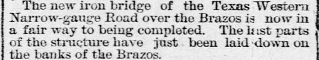
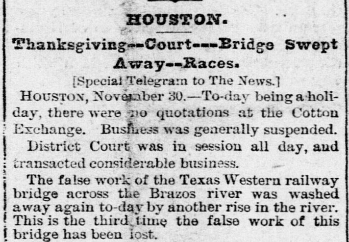
Upper Right:
The Galveston Daily News of October 4,
1882 carried the good news -- there was progress to report on the Texas
Western bridge over the
Brazos.
Lower Right:
But the Galveston Daily News of
December 1, 1882 also carried the bad news -- the false work for the
bridge (temporary supports during construction) had washed away for
the third time in a flood. Apparently, the bridge was mostly
complete by then because a mere six days later, the GC&SF began
advertising the Texas Western connection at Sealy.
The Texas
Western's narrow gauge construction limited its utility and caused
investors to shy away from financing an extension west to La Grange. The
railroad went into receivership in 1884 and was finally sold in 1895.
Operations stopped shortly thereafter and the rails were removed in
1900. |
 |
Passengers on the GC&SF
might have changed trains at Sealy to use the Texas Western connection for intermediate destinations
(e.g. Pattison), but they were less likely to disembark simply to reach Houston.
Most of the stations on the the GC&SF already had direct service to Houston on
other railroads, e.g. Galveston (GH&H), Arcola (I&GN), Rosenberg (GH&SA), and
Brenham (Houston and Texas Central , H&TC). What passengers did not have was a way to
reach Houston directly on the GC&SF. Bypassing Houston had been part of the
GC&SF's main line route plan at the outset (regardless of the reason),
but by 1882, the GC&SF had recognized that they needed to provide service to
Houston. It was growing rapidly, Buffalo Bayou was proving to be a functional outlet for Gulf shipping, and
the Bayou hosted excellent facility sites for industries that transported materials and products by
water. Most important of all, Houston had
essentially unlimited land, in sharp contrast to Galveston Island. For that reason alone,
the knowledge that Houston would eventually become the major population center in
southeast Texas was silently understood in Galveston, if not readily spoken (and
the Great Hurricane of 1900 would seal Galveston's fate.) A branch
line from the GC&SF main track at Alvin, a few miles east of Arcola, was built into
Houston in 1883.
Perhaps invigorated by its improved financial position
a year and a half after the ownership restructuring, the GC&SF completed
more than two hundred miles of track in 1881. One hundred of these miles was construction
from Brenham to Belton (which presumably retired the performance bond that had been posted as a
condition of the purchase of Galveston County's stock.) Nearing Belton, the tracks passed through
Temple, a construction camp named for the
railroad's chief engineer, Bernard Temple. From Temple, another 128 miles
was built north to Ft. Worth. A year later, the
GC&SF reached Dallas by acquiring a branch line out
of Cleburne, a major town on its main line south of Ft. Worth.
The GC&SF's rapid expansion of their route network was a strategic move,
capturing service areas and routes before their competitors did. It did nothing,
however, to solve their biggest problem -- they were almost entirely dependent on local
traffic. Yes, there was ocean freight being shipped in and out of Galveston
to and from out-of-state markets. But there was simply too little of
it, and the rate divisions they received on transfer traffic were less favorable
since they had limited leverage in negotiations. Competition from other ports (particularly New Orleans
and Houston) and other railroads
(especially the I&GN, the largest in Texas and part owner of the GH&H) was fierce.
Unless the GC&SF could find a partner to stimulate traffic from out-of-state
markets, they were destined to become subservient to the bigger railroads in Texas.
The obvious suitor for the GC&SF was the much larger Atchison, Topeka &
Santa Fe (AT&SF) Railway which did not yet have a Texas presence. The AT&SF
viewed Galveston as an attractive port for agriculture exports from the high
plains. The GC&SF's lengthy main line from Ft. Worth to Galveston would mesh
well with
AT&SF's network if the two railroads could establish an appropriate interchange
point. Negotiations led by George Sealy resulted in an 1886 agreement under which the AT&SF would
acquire the GC&SF on favorable terms if the GC&SF completed three construction
projects within a year. The specific projects were from Ft. Worth to Purcell, Oklahoma (where it
would meet an AT&SF line building south); from Dallas to
Paris (where it would meet
the St. Louis San Francisco Railway which was preparing to bridge the Red River nearby); and
from Cleburne to Weatherford (where a connection with the Texas & Pacific Railway would
establish a shortcut to west Texas, bypassing Ft. Worth.) The GC&SF was able to
lay 300 miles of track in one year to complete all of these projects, a
massive undertaking by any measure. The acquisition proceeded as planned in 1887
and the GC&SF began operating as a wholly-owned subsidiary of the AT&SF.
The year 1887 was also when the citizens of La Grange finally got their second
railroad. That year, the Missouri, Kansas & Texas (MK&T, "Katy") Railroad,
controlled by railroad magnate Jay Gould, built 90 miles
from Taylor south to Smithville and then east to Boggy Tank, passing through La
Grange eleven miles west of Boggy Tank. The Katy line was headed to Houston, and east
of Smithville, it was following the route surveyed by the Texas Western.
Construction did not proceed past Boggy Tank for another five years during which there was a
substantial
shakeup in Gould's financial empire. His control over the Katy lapsed just as a
new Texas Attorney General,
James
S. Hogg, had been elected on a campaign promise to wage legal attacks
against Texas railroads for poor service and non-competitive activities. Hogg (a
future Texas Governor) proceeded to sue the Katy in 1887 for non-compliance with
Texas' railroad ownership and service laws. In 1890, the Texas Supreme Court
affirmed a lower court's order against the Katy. In response, the Katy's Texas
holdings were consolidated in 1891 under a new state law that chartered the
"Missouri, Kansas & Texas Railway Company of Texas", a wholly-owned subsidiary of the
parent railroad (which was based in Missouri.) As a result of the new law, the Katy
was able to resume its quest to reach Houston. In 1892, 34 miles
of track was completed from Boggy Tank to the Brazos River, crossing the GC&SF at grade in Sealy. The Katy completed the
remaining 42 miles into Houston the following year.
In 1898 at
Eagle Lake, 18 miles southwest of Sealy, local
investors chartered a new railroad that would
eventually reach Sealy. Named the Cane Belt Railroad, their plan was to build
from Lakeside, a community one mile south of Eagle Lake, to Bonus, about ten
miles farther south. The GH&SA main line passed through Eagle Lake and there was
a spur to Lakeside to serve a sugar cane refinery. The Cane Belt negotiated to
acquire this spur from the GH&SA and continue the tracks south to Bonus. Construction
was completed in 1899 and the following year, an extension to
Wharton was built. At the same time, Cane Belt
management decided they would have better negotiating leverage on rate divisions
if they had another rail outlet to provide competition
for the GH&SA.
Sealy was served by two such competitors, the GC&SF and the Katy, so the Cane Belt
laid 18 miles of track from Eagle Lake to Sealy in 1900. On November 11, 1903,
the AT&SF acquired the Cane Belt and continued to operate it as a separate
railroad until the Texas Legislature authorized the GC&SF to lease it in 1905.
The Cane Belt was legally dissolved in 1948 and merged into the GC&SF.
In 1901, the Railroad Commission of Texas (RCT) began
exercising new authority granted by state law to regulate crossings of two
railroads for safety purposes, whether "at grade" or "grade-separated". At the
time, state law required all trains approaching a grade crossing with another
railroad to make a complete stop before proceeding across the diamond. The new
law was passed to allow RCT to specify rules and regulations for the engineering
and installation of interlocking safety devices and signals as a means of
allowing trains to proceed safely through a crossing diamond at speed. The
impetus was to eliminate unnecessary delays and reduce the water and fuel consumption
that otherwise resulted from trains coming to a dead stop and then proceeding across the
diamond while accelerating back to track speed. RCT issued a regulation mandating
that uncontrolled crossings be protected with a gate until an interlocker could
be installed. Regardless of whether a gate was installed, RCT rules still required trains approaching a non-interlocked crossing to come to a
complete stop. It seems likely however that trains approached gated crossings at limited speed and continued over the diamond if the gate was visible and not positioned
against them (else what purpose did the gate serve?) If the gate was positioned
against them, the train had to stop to permit a crewmember to swing it open to
allow movement across the diamond. If one track was substantially
busier than the other, the gate would typically be closed against the
less busy track and would only be opened while a crossing on that
track was underway. This
basic concept for traffic-mismatched crossings subsequently led to the use of
cabin interlockers, unmanned huts with interlocker controls operated by
crewmembers from trains on the lightly used track. In cases where both tracks
were busy, a manned interlocking tower could usually be justified. When neither track carried much
traffic, no interlocker would be installed; a gate was sufficient under the
theory that the expense of installing and maintaining an interlocker to minimize
delays and fuel consumption could not be justified if trains seldom used the
route.
The GC&SF/Katy grade crossing at Sealy
needed to be interlocked, but it was not prioritized by RCT. RCT had to review
and approve the engineering design and operating plan for every interlocker, so
they elected to focus their limited staff resources on locations where two busy
rail lines crossed, particularly if such crossing was not near a depot, rail yard
or regular water stop (...because trains tended to
stop at those places anyway.) Although there was adequate traffic, Sealy was low
priority because it had a depot at the crossing and yards nearby. An interlocker
offered limited benefit; trains would mostly be stopped, or moving slowly,
anyway when
they were near the crossing at Sealy.
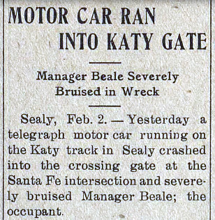 |
Left and
Right: Twenty-two rail
miles west of Sealy sits the tiny town of New Ulm, Texas. With a
masthead that read "Only Daily Newspaper in the World Published in a
Town of Less Than 500 Population", this
New Ulm Daily Enterprise story on February 3, 1914 described
an accident at Sealy that involved a "telegraph motor car", likely a
small, gasoline-powered vehicle that ran on rails to carry linemen to
inaccessible locations. The motor car ran into the "crossing gate at the
Santa Fe intersection", establishing that in 1914, the Sealy crossing
was in compliance with RCT regulations requiring a gate to be in place
until an interlocker was installed (which for Sealy would not be until
1931.) It also suggests that the gate was typically closed against the
Katy, the less busy track. Railroads commonly used a "swing gate" that
could be positioned easily across either rail line. Such gates had
reflective "stop signs" on both sides, visible from a distance. At some
locations, the gate was retained when the
crossing became interlocked; releasing the latch to swing the gate
against the busier line would trigger the interlocker to set the distant
signals to "Stop", indicating that the crossing was occupied. After the
train had crossed, the gate would be returned to its normal position and
latched, triggering the return of the distant
signals to the "Proceed" indication. Note that
distant signals didn't exist on the less busy track because those trains
always stopped at the gate; a fixed warning sign was
sufficient. |
|
Each year, beginning with the Annual Report issued on December 31, 1902, RCT
published a list of interlockers that had been
approved for operation, including the location and the railroads involved. A
year later, the list was expanded to include the type
of interlocker, the number of active functions in the interlocking plant, the
company that installed it, and
the commissioning date. This continued through the Annual Report issued at the end of
1930, and then the practice ceased. Sealy did not
appear in any of these lists until the final interlocker table dated December
31, 1930 was published. That list showed that Sealy's interlocker had been nomenclatured as Tower 163 in RCT's numbering system,
but the commissioning date was stated simply as "Under Construction",
and the type of interlocker and its function count were omitted. Sealy was the
first interlocker to be so listed. Full details were provided for the prior entry in the
list, Tower 162 at Sugarland Junction. There
were seven interlocker entries after Sealy (through
Tower 170 at Conroe) that were likewise shown as "Under Construction". For
Sealy, the railroads involved were identified as the GC&SF and the "MKT". "MKT"
had become the recognized abbreviation for the Katy railroad (replacing "MK&T")
when "Missouri - Kansas - Texas" was established as the new name of the company
coming out of bankruptcy reorganization in 1923. An RCT list dated December 31,
1926 was the first to use "MKT", and this abbreviation was back-substituted
throughout that list (and used in all subsequent lists.)
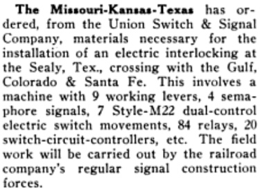 Left:
The July, 1931 issue of Railway Signaling and
Communications carried this news item of the Katy's order for
materials to be used for an interlocker installation at Sealy. The order was
probably made a few months earlier since the Tower 163 interlocker was
commissioned at Sealy the month after this item was published.
Left:
The July, 1931 issue of Railway Signaling and
Communications carried this news item of the Katy's order for
materials to be used for an interlocker installation at Sealy. The order was
probably made a few months earlier since the Tower 163 interlocker was
commissioned at Sealy the month after this item was published.
Starting at the end of 1931, RCT
only
intermittently listed details of newly
commissioned interlockers. The Tower 163 information that was eventually published
listed a
19-function Mechanical-Electrical interlocker installed on
August 27, 1931. This was an interesting designation for the type of
interlocker, as it had only appeared once before in RCT's lists, for
Tower 162 at Sugar Land Junction, a couple of miles west of Arcola.
Tower 176
at Jacksonville was also identified as a Mechanical - Electrical
interlocker, but it only had four functions and is known to have incorporated a
swing gate. Given the Katy's order (left) for a Union Switch & Signal
interlocking system with "9 working levers", it is likely that this was a
manually operated plant with controls installed inside Sealy's Union
Depot (to be operated by station personnel or train crew.) The significance of the Mechanical - Electrical interlocker
type designation remains an open question. As would be expected for the railroad
that ordered and installed the interlocker, the Katy is
also known to have been responsible for maintaining it. Railroads typically
shared interlocker maintenance expenses on a "weighted function" basis, but the
function assignments for the Sealy interlocker have not been identified. It was eventually converted
to an automatic interlocking system, probably in the 1950s.
 Right:
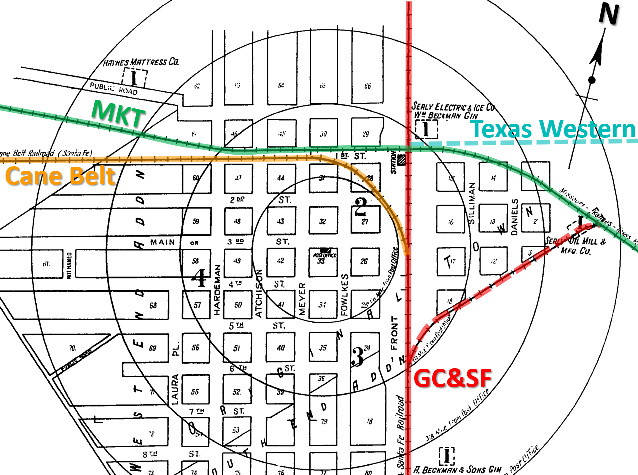
This index to the 1925 Sanborn Fire Insurance map set of Sealy has been
annotated
to show the paths of the railroads through town. All of the solid lines are tracks that still exist (albeit under different ownership); the Texas Western rails were taken up c.1900. Sanborn's cartographer drew the
map tilted about 12.5 degrees east of due north. This causes the GC&SF main line
to appear vertical whereas its actual heading is north-northwest at
347.5 degrees. Similarly, the map tilt causes the inaccurate visual that the
Texas Western and Cane Belt arrived in downtown Sealy on due west and due east
headings, respectively. Off the map to the left, the Cane Belt curved
substantially southwest onto a 213.9-degree heading toward Eagle Lake. Those
tracks are still intact out to approximately two miles from downtown to serve Sealy Transload, a facility for loading and unloading railcars. Where the former Cane
Belt and Katy tracks are parallel (for approximately 1,000 ft.), there is a
single crossover to facilitate eastbound-to-southbound and
northbound-to-westbound movements between the main lines (which support
important trackage rights held by the current owners.)
Right:
This index to the 1925 Sanborn Fire Insurance map set of Sealy has been
annotated
to show the paths of the railroads through town. All of the solid lines are tracks that still exist (albeit under different ownership); the Texas Western rails were taken up c.1900. Sanborn's cartographer drew the
map tilted about 12.5 degrees east of due north. This causes the GC&SF main line
to appear vertical whereas its actual heading is north-northwest at
347.5 degrees. Similarly, the map tilt causes the inaccurate visual that the
Texas Western and Cane Belt arrived in downtown Sealy on due west and due east
headings, respectively. Off the map to the left, the Cane Belt curved
substantially southwest onto a 213.9-degree heading toward Eagle Lake. Those
tracks are still intact out to approximately two miles from downtown to serve Sealy Transload, a facility for loading and unloading railcars. Where the former Cane
Belt and Katy tracks are parallel (for approximately 1,000 ft.), there is a
single crossover to facilitate eastbound-to-southbound and
northbound-to-westbound movements between the main lines (which support
important trackage rights held by the current owners.)
Historic aerial imagery shows that the former GC&SF exchange track (dashed
red line) with the Katy was removed prior to 1958 and was replaced by a shorter transfer
track (which remains intact) in the southeast quadrant, much closer to the
crossing. The imagery also shows that by 1958, a previous northeast quadrant transfer
track was no longer in place.
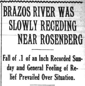
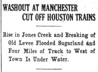
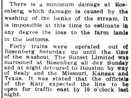
Below: The Houston Post
of Monday, May 3, 1915 reported that flooding had washed out four
miles of the GH&SA tracks between Sugarland and the Brazos River on Saturday
evening, stranding SP's eastbound Sunset Limited
passenger train at Rosenberg. Late Sunday, the Sunset Limited turned north at
Rosenberg, proceeded to Sealy on the GC&SF line, and took the exchange track to
reach Katy rails and head east into Houston once Katy's Brazos River bridge
reopened.
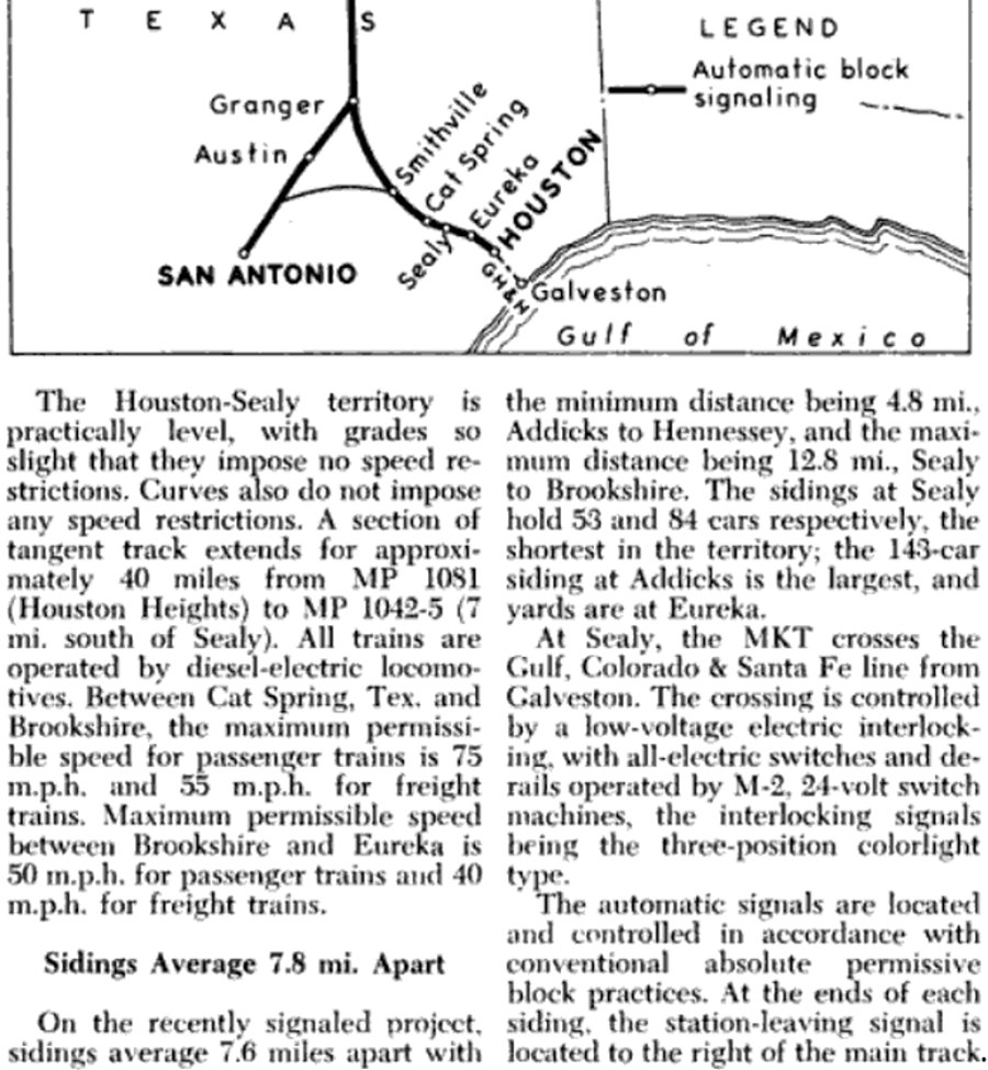
 Left:
This excerpt is taken from the May, 1954 issue of
Railway Signaling and Communications. A
lengthy article discussed the Katy's completion of Automatic Block Signaling
(ABS) between Houston and Sealy, the last component of a system-wide ABS upgrade
covering a 1,138-mile expanse from Kansas City to Houston and San Antonio via
Ft. Worth and Dallas. The article notes that it took a little over eight years
to complete the last 430 miles (with additional work remaining between Parsons,
KS and St. Louis.) Traffic along the newly signaled territory between Houston
and Sealy "...consists of one passenger train and two regular freight
trains each way daily, and one local freight each way daily except Sunday.
Additional freight trains are run as traffic warrants..."
Left:
This excerpt is taken from the May, 1954 issue of
Railway Signaling and Communications. A
lengthy article discussed the Katy's completion of Automatic Block Signaling
(ABS) between Houston and Sealy, the last component of a system-wide ABS upgrade
covering a 1,138-mile expanse from Kansas City to Houston and San Antonio via
Ft. Worth and Dallas. The article notes that it took a little over eight years
to complete the last 430 miles (with additional work remaining between Parsons,
KS and St. Louis.) Traffic along the newly signaled territory between Houston
and Sealy "...consists of one passenger train and two regular freight
trains each way daily, and one local freight each way daily except Sunday.
Additional freight trains are run as traffic warrants..."
The Katy
also installed flood detectors (above right)
at bridges over creeks that were prone to flooding (certainly a good idea in
southeast Texas!) The detectors were integrated into the ABS system so that
approaching trains would not enter a block where a flood had been detected.
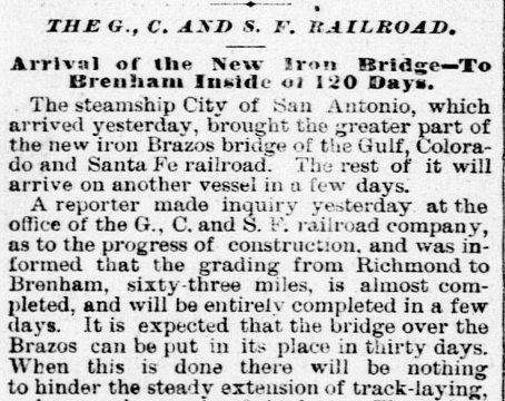
In 1964, the GC&SF corporate entity was dissolved and the
entire enterprise was merged into the AT&SF. At the end of 1996, the AT&SF
merged with the Burlington Northern Railway to create Burlington Northern Santa
Fe (BNSF), which continues to operate the former GC&SF main line as a major
artery between Galveston, Ft. Worth and points north. The Katy railroad remained
independent until Union Pacific (UP) acquired it in 1989 and merged it into
another UP-owned railroad, the Missouri Pacific (MP). (This was a hundred years after MP had lost its lease on the Katy when
Jay Gould's rail empire collapsed.) UP merged with SP in 1996,
and a few years later, MP and SP became fully integrated into UP and ceased to
exist as separate corporations.
In 1997, the former Katy tracks were cut
22 miles east of Sealy in the town of Katy, creating a lengthy industrial spur
served from Sealy. The remainder of the Katy line into
Houston was abandoned. As part of the BNSF merger and the UP/SP merger, UP
obtained trackage rights on the former GC&SF tracks from Sealy to Galveston,
while
BNSF has trackage rights on the former Katy tracks from Sealy to Smithville and San
Antonio. UP trains arriving at Sealy from the west can take the BNSF tracks
south to Rosenberg and return to UP (ex-GH&SA/SP) tracks there. Although
relatively few trains operate on the former Katy tracks east of Sealy, the
automatic interlocker at Sealy remains operational.
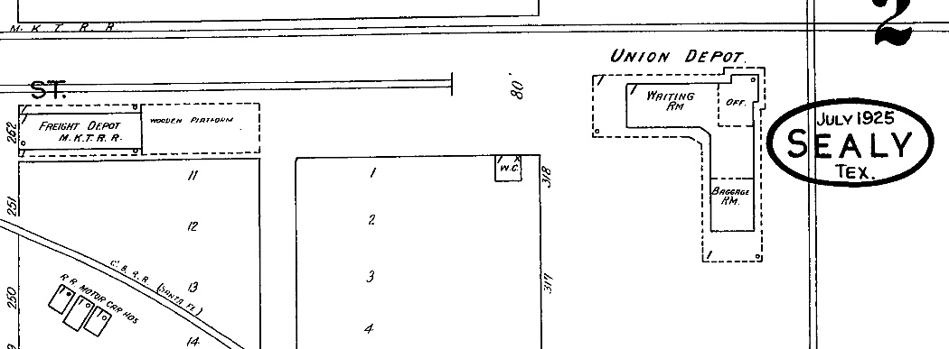
Above: The 1925 Sanborn Fire
Insurance map of Sealy shows the Union Depot in the southwest corner of the
Tower 163 crossing, with its privy ("W. C.") nearby. The Katy freight depot is
visible along the tracks west of the Union Depot. The GC&SF freight
depot was adjacent to the GC&SF tracks a similar distance south of the Union
Depot. A piece of the Cane Belt ("C. B. R. R.") transfer track is visible in the
lower left corner. A consultant's
report funded by the Katy's bankruptcy receiver in 1917 stated that the operating
expenses for the Sealy Union Depot were split evenly between the two railroads.
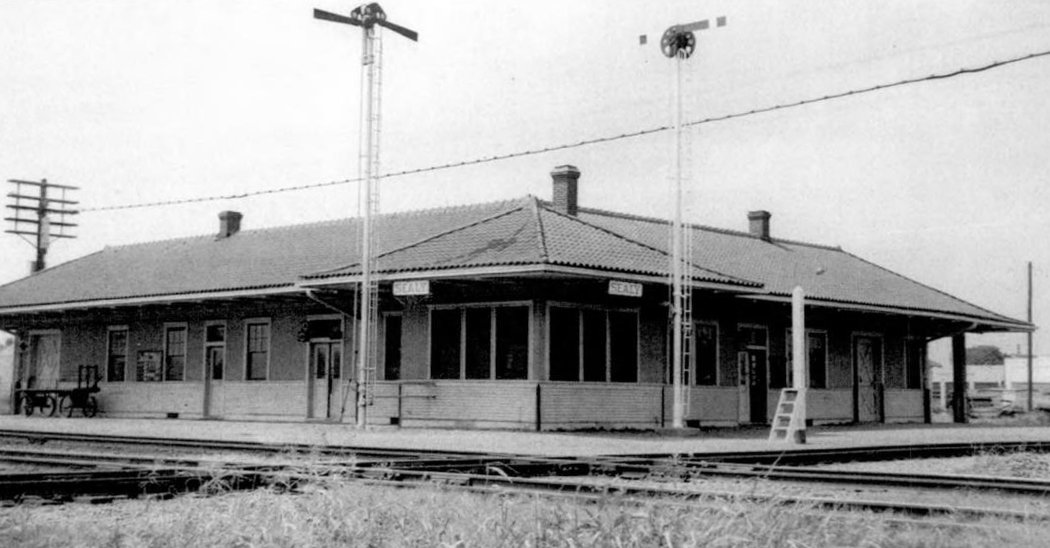
Below: This photo of the
Sealy Union Depot (Temple Railroad & Heritage Museum) is undated.
Originally, the Katy and GC&SF had separate passenger depots. Newspaper articles
referring to "Union Station" in Sealy appear at least as early as 1917, and an
article in Railway Review
published December 26, 1914 states that a new passenger station in Sealy had
been completed that year. This depot appears
identical to the one in the 1959 photograph, but it has not been
determined whether it is the 1914 station or possibly a later one that replaced
it. The Sealy Union Depot is reported to have been razed in late 1969 or early 1970.
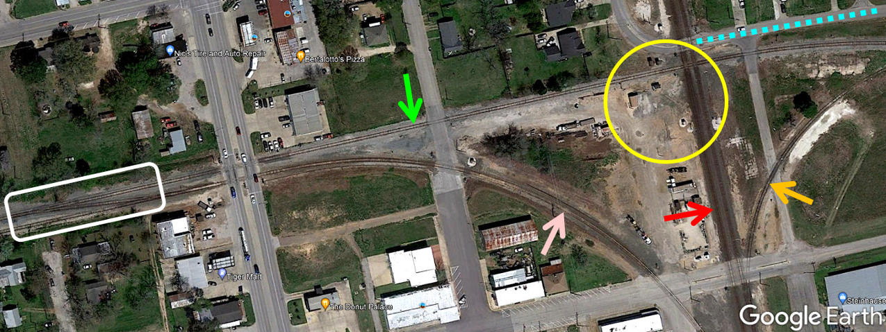
Above: This annotated Google Earth satellite image of
the vicinity of the Tower 163 crossing shows that the Sealy Union Depot is no
longer standing in the southwest quadrant of the crossing (yellow circle), where
the Katy (green arrow) and the GC&SF (red arrow) cross at a right angle. The
former GC&SF line has two tracks at the crossing, merging back to a single main
line at a switch a tenth of a mile north of the crossing. To the south, a small,
six-track yard remains in operation. Diagonally across from the depot site, the
Texas Western ROW (blue dashed line) sits beneath San Felipe Rd. for three
quarters of a mile, where the road ends. The Cane Belt connection (pink arrow)
to the GC&SF also served as an exchange track for the Katy using the crossover
(white rectangle) a quarter mile west of the crossing. The southeast quadrant
connector (orange arrow) was relocated from its original spot farther south
sometime prior to 1958.
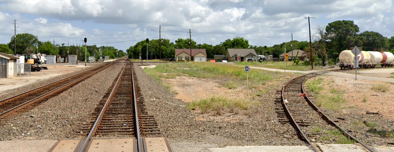
Above: This Google Street View image from June, 2022
looks north on the BNSF tracks toward the Tower 163 crossing. The exchange track
at right is still in use, but note the red derail installed to prevent rail cars
from accidentally rolling back into the BNSF yard. Various railroad equipment
now occupies the former depot site at left.
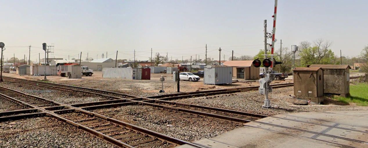
Below: This Google Street View from March, 2021 looks southwest
across the diamonds, essentially the same view as the undated depot photo above.
The former depot site now supports a variety of rail maintenence activities.
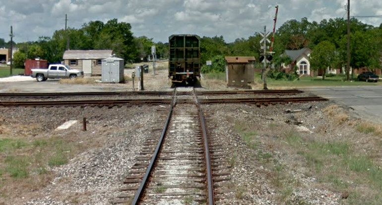 Left:
This Google Street View from July, 2011 looks west across the diamonds from E.
Front St. A railcar has just cleared the BNSF tracks (although the car may have been
stationary at the time of the photo.)
Left:
This Google Street View from July, 2011 looks west across the diamonds from E.
Front St. A railcar has just cleared the BNSF tracks (although the car may have been
stationary at the time of the photo.)
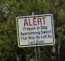
Below: In
the image at left, the sign visible trackside to the right of the
railcar says "ALERT Prepare to Stop Approaching Switch
That May Be Left As Last Used."