A Crossing of the Gulf, Colorado & Santa Fe Railway and the San Antonio & Aransas Pass Railway
The town of Wallis was named for J. E. Wallis, a director of the Gulf,
Colorado & Santa Fe (GC&SF) Railway, although the community had existed under
the name "Bovine Bend" for several years prior to the railroad's arrival. Santa
Fe was building its initial route from Galveston to Temple when it passed
through this area in 1880. A few years later, the San Antonio & Aransas Pass
(SA&AP) Railway was charted to build a railroad between its namesake cities, and
by 1887, this construction was complete. Desiring to serve the growing
Galveston-Houston area, the SA&AP built a branch line from Kenedy to Wallis in
1887, continuing to Houston in 1888. Tower 51 was commissioned to control the
SA&AP/GC&SF crossing in Wallis and began operations on July 20, 1904. The next
day, another SA&AP/GC&SF crossing, Tower 52
in Cameron, was commissioned for operations.
SA&AP was eventually acquired by Southern Pacific (SP), and ultimately, the
former SA&AP route into Houston was retired. The former GC&SF route through
Wallis remains in active use by successor Burlington Northern Santa Fe (BNSF).
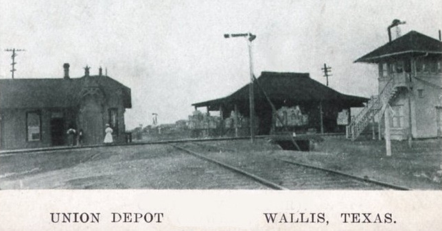
Ken Stavinoha provides this 1910 photo (above) of the crossing in Wallis and
describes it as...
"...left to right – Union Depot (1st
edition, built by the SA&AP – this building survives
today but away from the tracks), then the Wells Fargo & Co Express Building, and finally
Tower 51. This view is looking west along the SA&AP toward Eagle Lake. Modern
day Highway
36, which parallels the former GC&SF through Wallis, would be just beyond Union
Depot
and the Wells Fargo building."

Above: 1951 photo by K. B.
King of the Wallis
crossing, annotated by Chris Zurek. Chris explains...
"Due to the Jim Crow
laws, the depot had separate waiting rooms for whites and coloreds.
The whites had indoor restrooms, the coloreds had outhouses east of the depot.
Later the
depot was remodeled and there was only one waiting room. When I was a kid in the
early 70s,
the holes in the ground were still there from the outhouses."
(Russell
Crump's Santa Fe Photo Archive)
Ken Stavinoha comments on a better print he has seen of the K. B. King photo...
"Upon close inspection, the image clearly shows a rectangular number
board with 51 above the bay window. This second Union Depot was built by the
GC&SF in 1922 or possibly 1923 (blueprints are dated May 1922). The use of the
large bay window indicates that train order signal levers would be housed in the
depot – this is per Santa Fe standard plans – so it appears the plan was to
retire Tower 51 and relocate the signal function to the depot sometime after
completion. Former SP Agent Mary Meyer started clerking in Wallis in 1945 and
said there were four levers in the operator’s desk at the bay window. These
would have been labeled North and South for the Santa Fe pair of levers – East
and West for the SP (former SA&AP) levers."
Chris Zurek adds...
"I interviewed Mary Meyer in 1988 (at Tower 17) and she drew a
diagram of the Wallis Union Depot for me. Over the years I lost the diagram so
I'm going by memory here. It did have a four function plant, electrical pistol
grip like in Tower 17. The console was behind the operator at the bay window,
she told me that you had to turn completely around to line a train through the
crossing. The Santa Fe train order signal was across the tracks from the depot,
the rods went under the track through a pipe (this pipe was still visible until
1991 when the Santa Fe installed new rail). The handles were in front of the
operator in the bay window. The SA&AP/T&NO train order signal was on the north
side of the building, the handles were to the right of the operator. I think the
depot was torn down in 1967 (I was only three so I don't remember it)."
Bird's Eye View, Tower 51 Site, annotated by Chris Zurek
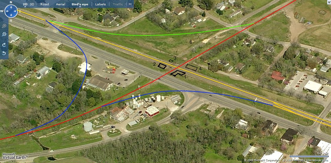
This north-looking bird's eye view of the Tower 51 site shows the BNSF tracks
paralleling Highway 36 with the remnants of the SA&AP
right-of-way crossing at approximately
a right angle in the center of the image.
The annotations provided by Chris Zurek are:
Yellow: GCSF/ATSF/BNSF
Red: SA&AP/T&NO/SP
Blue: old interchange tracks
Green: connecting track, Southern Pacific Santa Fe (SPSF),
1986
1: original SA&AP Union Depot
2: Wells Fargo Express building
3: Tower 51
4: Santa Fe Union Depot (c.1922)
5: Chris' grandmother's house
6: location where SA&AP depot
was moved when the Union Depot was built
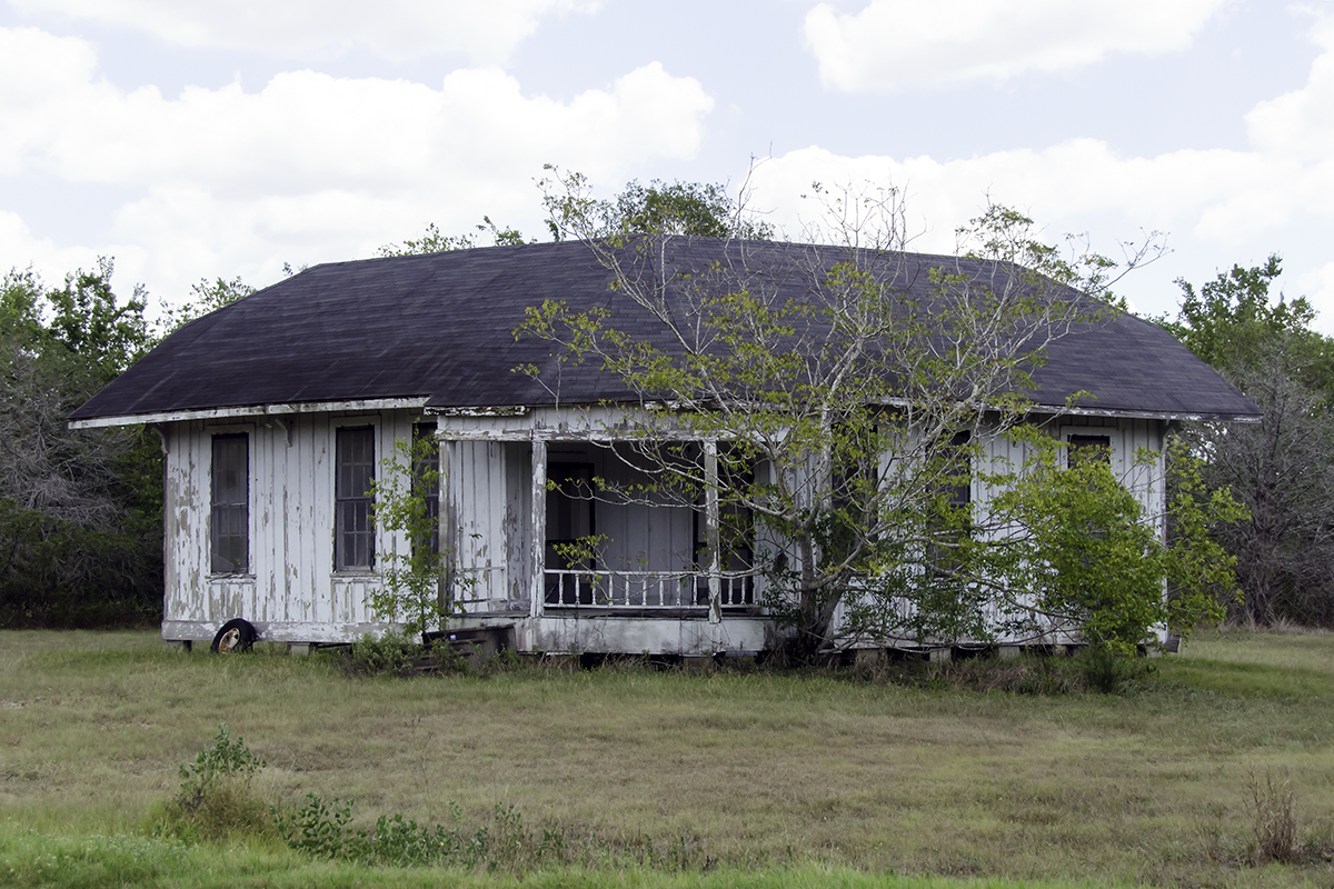
Chris Zurek explains the relocation of the SA&AP depot...
"When GCSF built the Union Depot, the interlocker functions and train order
functions for both railroads were moved into it. The SA&AP depot was moved to a
lot on Columbus Road (between Railroad St and Guyler) and used as a residence,
at first for the SA&AP/T&NO agent. In the 1970s, my friend's aunt lived there
and I was in the building. At the time I thought it was strange that it was not
built to a 90 degree angle (it was 73 degrees to match the diamond). In 1986,
when the Santa Fe and Southern Pacific were trying to merge into SPSF, a
connecting track was built in the NE quadrant. Most of the buildings in that
block were torn down but the old SA&AP was moved to a field east of town."
Below: And according to the image below which Chris provided, the depot is still
there!
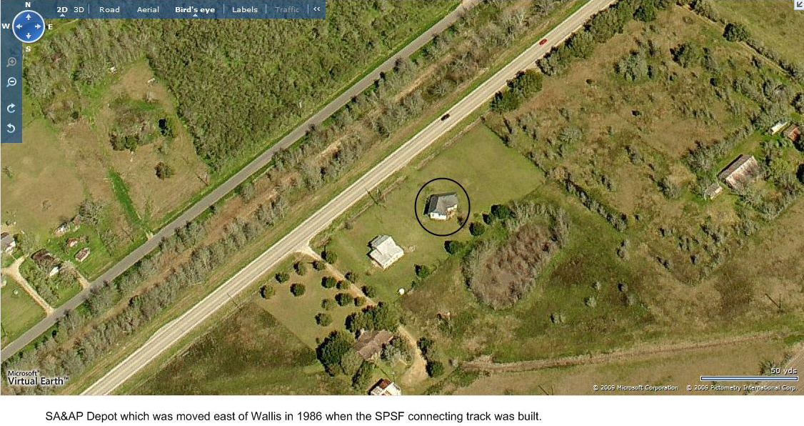
Below: Roger Mitchell supplies this image of the relocated
SA&AP Union
Depot.