Texas Railroad History - Tower 17 - Rosenberg
A Crossing of the Galveston, Harrisburg & San
Antonio Railway and the Gulf, Colorado & Santa Fe Railway
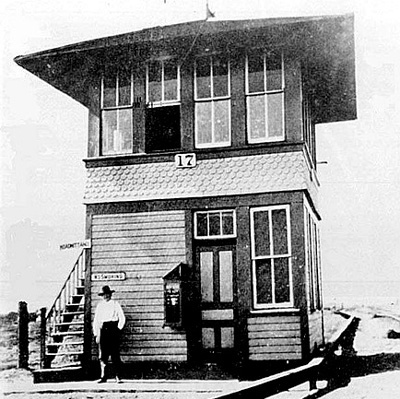
Above Left:
This photo shows the east face of the original Tower 17
as it appeared in 1907. The gentleman in the photo is C.C. Harris
who was employed as a towerman. (Rosenberg Railroad
Museum courtesy of Ken Stavinoha) Above
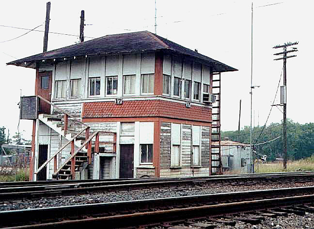
Right: Tower 17 was enlarged in the 1950's when additional
operators were moved from the Rosenberg depot to the tower. The ground floor
door and window on the east face remain in the same position as in the 1907
photo, but the tower has been expanded on the south side, necessitating removal
and redesign of the staircase. The Queen Anne style "fish scale" pattern between
the floors (common to SP towers, e.g. Tower 16) is
the same as in the 1907 photo but appears only beneath the original four
windows. (Jim King photo c.1997)

Above:
George Werner took this photo of an eastbound Southern Pacific train crossing
the diamond on January 4, 1969 (from Southern
Pacific's Eastern Lines 1946-1996, D. M. Bernstein, 2015)
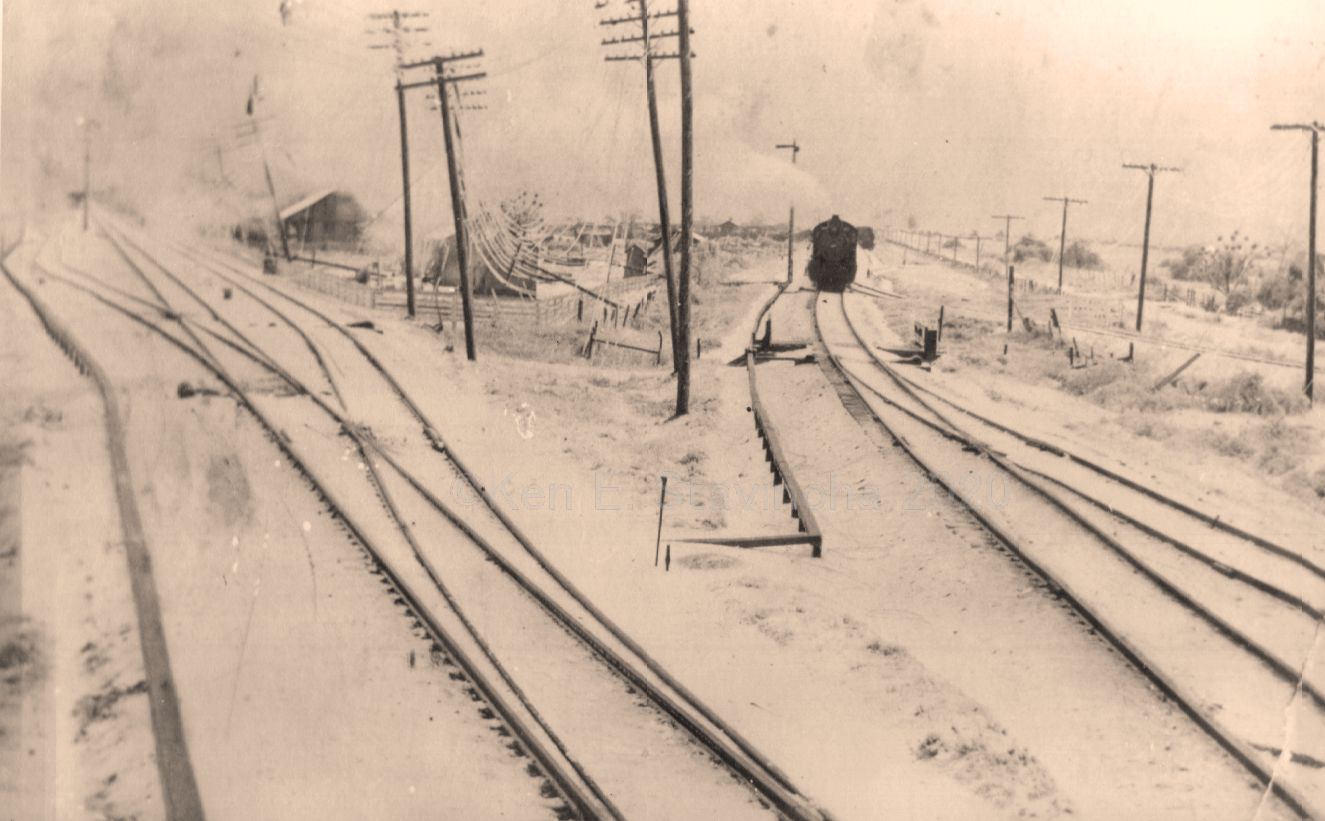
Below: This undated photo was
taken facing northwest from a window of Tower 17 during a rare winter storm.
Informed speculation suggests December, 1924 as a possible date. It shows a
southbound Santa Fe train waiting near a downed utility pole with ice-covered
wires. (Ken Stavinoha collection)
The town of Rosenberg was
founded when the Gulf, Colorado & Santa Fe (GC&SF) Railway built through
the coastal prairie southwest of Houston in 1879, crossing
the rail line of the Galveston, Harrisburg and San Antonio (GH&SA) Railway three
miles west of Richmond. The GH&SA tracks had been there for more than two
decades, originally as the Buffalo Bayou, Brazos
and Colorado (BBB&C) Railway, the first railroad in Texas, chartered several years before
the Civil War. The BBB&C had begun at
Harrisburg on Buffalo Bayou southeast
of Houston and had laid twenty miles of track west to Stafford's
Point in 1853. By 1855, twelve additional miles had been built to Richmond, the county
seat of Fort Bend County. Reaching Richmond, on the west bank of the Brazos
River, required the BBB&C's first major river crossing. By 1860, tracks
had been laid 48 miles farther west to the tiny community of Alleyton, three
miles east of the Colorado River, a river the BBB&C did not plan to cross.
Instead, the BBB&C charter called for the railroad to remain east of the
Colorado and
follow the river north to La Grange and Austin. Columbus, three miles farther west on the opposite bank of the river, was
determined to obtain railroad service given the proximity of the BBB&C tracks. Its citizens chartered
the Columbus Tap Railroad to build from Alleyton to the river and bridge it into Columbus, but the outbreak of the Civil War delayed those plans. After the
War, the tracks were built from Alleyton to the east bank of the river and a
ferry was used to move goods and passengers across it. In 1866, the Legislature
gave the BBB&C authorization to buy the Columbus Tap, but the Tap retained its
separate legal existence, likely due to the BBB&C's impending default. Post-war economic conditions
had left
the BBB&C unable to make payments on its construction contract. As a result,
an 1867 court
judgment awarded the BBB&C to the contractor, William Sledge.
 Sledge
was stuck with the BBB&C so he tried to make something of it. A newspaper
article in the La Grange States Rights Democrat
of May 24, 1867 reports the details of a meeting Sledge attended six days
earlier to discuss the BBB&C's plans to resume construction toward La Grange.
The article notes "The cost of the bridge now being built at Columbus was an
affair undertaken by the people of Columbus and Colorado County, and the
building of the bridge above Columbus it was desirable should be undertaken by
the people of La Grange and Fayette County." The significance of this
article and this specific passage is that the Colorado River bridge for the
BBB&C was already in progress and was being funded by citizens of Columbus. The
backers were likely the same people who had chartered the Columbus Tap. Columbus
was the county seat of Colorado County, definitely worthy of rail service once
the bridge was finished. But rather than make it a "tap spur" from Alleyton as the
Columbus Tap had envisioned, the BBB&C preferred to operate through Columbus and
then turn north and cross the Colorado River again to get back to the surveyed
route to La Grange. This explains the need for a "...bridge above
Columbus...", hopefully to be funded by "...the citizens of La Grange
and Fayette County..." If Columbus was served by the BBB&C on a through
route, a second bridge over the Colorado would be required
somewhere because La Grange sits entirely on
the opposite bank of the river from Columbus.
Sledge
was stuck with the BBB&C so he tried to make something of it. A newspaper
article in the La Grange States Rights Democrat
of May 24, 1867 reports the details of a meeting Sledge attended six days
earlier to discuss the BBB&C's plans to resume construction toward La Grange.
The article notes "The cost of the bridge now being built at Columbus was an
affair undertaken by the people of Columbus and Colorado County, and the
building of the bridge above Columbus it was desirable should be undertaken by
the people of La Grange and Fayette County." The significance of this
article and this specific passage is that the Colorado River bridge for the
BBB&C was already in progress and was being funded by citizens of Columbus. The
backers were likely the same people who had chartered the Columbus Tap. Columbus
was the county seat of Colorado County, definitely worthy of rail service once
the bridge was finished. But rather than make it a "tap spur" from Alleyton as the
Columbus Tap had envisioned, the BBB&C preferred to operate through Columbus and
then turn north and cross the Colorado River again to get back to the surveyed
route to La Grange. This explains the need for a "...bridge above
Columbus...", hopefully to be funded by "...the citizens of La Grange
and Fayette County..." If Columbus was served by the BBB&C on a through
route, a second bridge over the Colorado would be required
somewhere because La Grange sits entirely on
the opposite bank of the river from Columbus.
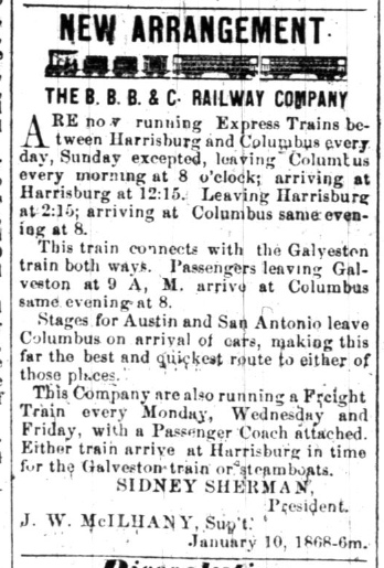
Left: The BBB&C bridge into
Columbus was apparently completed sometime later in 1867 because the
La Grange States Rights Democrat of January
10, 1868 carried this advertisement announcing new BBB&C Express Trains between
Harrisburg and Columbus. Note that "Stages for Austin and San Antonio leave
Columbus on arrival of cars..." Both of those towns lacked rail service, but a
western extension of the tracks at Brenham was
already being seriously contemplated for Austin, which would see its first train in December, 1871.
San Antonio also lacked rail service and, as the second largest city in Texas,
was desperate to obtain it. With the BBB&C committed to building north out of
Columbus to La Grange, there was extensive (but ultimately non-productive)
activity in San Antonio to sponsor a railroad to Columbus to intersect with the
BBB&C.
Although Sledge carried on and tried to generate revenue from
his railroad, Thomas Peirce had bigger and better ideas for it. Peirce (with the unusual ei spelling of his
last name) was a wealthy Boston businessman, lawyer and landowner (including a
large sugar plantation near Arcola.) He had done legal work for the BBB&C before
the War, so he was familiar with it. Peirce formed an investor group for the
purpose of acquiring the railroad from Sledge; Sledge agreed to the sale in
1870. The BBB&C was not in great shape, so Peirce rehabilitated it and improved
its operations. This was essential to set a reputation going forward. Peirce had
a vision of what he wanted to do, and like all wealthy businessmen, he planned
do it with other people's money. But investors would not sink money into his
larger vision if the railroad couldn't manage its existing operations.
Peirce and his investors eventually petitioned the
Legislature to modify the BBB&C's charter to authorize Peirce to implement
his plan,
which was...building to
San Antonio instead of to La Grange and Austin. The
citizens of La Grange protested, so the Legislature granted the request to build
to San Antonio but retained a requirement to build
a branch line to La Grange (which Peirce eventually fulfilled in 1881.) The
revised charter also allowed the railroad to connect with
any railroad to the Pacific (an innocuous provision that proved to have a
profound impact.) The railroad's name was also revised; it
would be the Galveston, Harrisburg and San Antonio (GH&SA) Railway. Peirce
bought out most of the other investors and initiated construction west from Columbus toward San Antonio,
reaching Luling, 71 miles from Columbus, by the end
of 1874. As part
of his efforts to
publicize his westward march toward San Antonio, Peirce coined the term "Sunset
Route", a name that remains familiar to every
railroader today, nearly 150 years later. As Columbus was roughly halfway
between Harrisburg and San Antonio, the GH&SA established a maintenance base on
the west outskirts of town in 1885. The community that grew up around it, known
as Glidden, remains unincorporated, but continues to provide the name for the
rail segment of the Sunset Route between San Antonio and Harrisburg, known as the Glidden
Subdivision, now operated by Union Pacific (UP).
The GH&SA's rails reached San Antonio
in 1877, and within a year, Peirce and Southern Pacific (SP) Chairman Collis
Huntington were discussing a potential partnership. SP was building east from
California to Yuma, Arizona. Huntington had decided they would continue past
Yuma all the way to El Paso, and he had obtained
permission from the territorial governments of Arizona and New Mexico to do so.
Huntington wanted to create a southern transcontinental route close to Mexico
via El Paso and San Antonio, while also serving Gulf ports at Houston and New
Orleans. This required building 800 miles across Texas, but SP did not have a
charter from the State of Texas. The chances of getting one anytime soon were
poor; the other major railroads in Texas would fight it vigorously in the
Legislature. Hence, Huntington's attention turned to the GH&SA for obvious
reasons. The GH&SA
did have a state charter that already authorized
construction to connect with any Pacific railroad, and it
did have a rail line covering part of the distance between El Paso and
Houston. It also had rights to operate into downtown Houston on the
International & Great Northern (I&GN) from Pierce Junction
(which had been Peirce Junction until the Post Office forced a spelling
change!) The GH&SA had everything Huntington needed except tracks between
San Antonio and El
Paso.
Building to El Paso would be a significant financial undertaking
for Peirce, but Huntington wanted to act fast; he needed to have a route between
El Paso and Houston in place by the time SP reached El Paso from Yuma. His
solution was to have SP finance the entire job for the GH&SA, with construction
teams building from both directions to meet in the middle. Both men understood
that by loaning the funds, SP would hold substantial GH&SA debt and be
well-positioned to acquire it outright, yet Peirce was agreeable. At age 60, he
had already surpassed life expectancy for that era, he couldn't run the GH&SA
forever, and he could ensure its long term viability by partnering with SP. By
the summer of 1880, an agreement between the two men was in place and SP survey
crews were sent to Texas to map the route. Peirce contracted with SP's Southern
Development Co. to field construction forces working east from El Paso. Their
work began in June, 1881 on behalf of the GH&SA while Peirce's own construction forces built west from San Antonio. After a
bit more than a year and a half, the two
railroads met at the Pecos River on January 12, 1883, where
Huntington and Peirce drove a Silver Spike signifying completion of a major
portion of a southern transcontinental
rail line. [It was not the southern transcontinental
rail line because the Texas & Pacific (T&P) Railway, controlled by rail
baron Jay Gould, was building west from Texarkana
to San Diego under a national charter granted by Congress. The T&P had been significantly delayed by financial issues;
construction had finally proceeded west of
Ft. Worth but it was still a long ways from El Paso. As SP began building east
from El Paso on behalf of the GH&SA, Gould realized he had little choice but to compromise with
Huntington.]
As SP trains began operating to Houston, SP leased the GH&SA for several years and ultimately acquired it.
Less than three years after the Silver Spike ceremony, Peirce died at age 67.
In 1875, as GH&SA construction was getting closer to San Antonio, the GC&SF was
just getting started out of Galveston. It had been
chartered in 1873 with a conceptual plan to build from Galveston to the Texas
Panhandle, continuing to Colorado. An unusual provision in the charter allowed the
Galveston County government to buy stock in the railroad, which they did, a half
million dollars worth! This was two-thirds of the issued stock, giving the
Galveston County Commissioners
controlling interest in the railroad should they choose to exercise it. The GC&SF's first step was to build a new
rail bridge from Galveston Island to the mainland at
Virginia Point; it was promptly damaged by a hurricane in September, 1875,
necessitating $25,000 in repairs. From Virginia Point, construction proceeded northwest toward
Richmond. The GH&SA would soon be serving San Antonio, hence the GC&SF envisioned
Richmond as a valuable interchange point for trade between San Antonio and
Galveston, the two largest cities in Texas. Beyond Richmond, the GC&SF would go
northwest, staying between the Brazos and San Bernard
Rivers where they converge to a separation of slightly under four miles at the
narrowest point.
 GC&SF
construction from Virginia Point toward Richmond was slow; only
the first 42 miles to Arcola was complete by 1877. But having finally reached
"somewhere", Arcola was promoted as a significant milestone for the GC&SF
because it was also a stop on the I&GN line out of Houston. The GC&SF
decided to advertise its progress (as if reaching Arcola could be counted as
such!) by running a VIP excursion train out of Galveston that went to Arcola,
turned north on the I&GN to
Pierce Junction, and then headed west to Richmond on the GH&SA.
GC&SF
construction from Virginia Point toward Richmond was slow; only
the first 42 miles to Arcola was complete by 1877. But having finally reached
"somewhere", Arcola was promoted as a significant milestone for the GC&SF
because it was also a stop on the I&GN line out of Houston. The GC&SF
decided to advertise its progress (as if reaching Arcola could be counted as
such!) by running a VIP excursion train out of Galveston that went to Arcola,
turned north on the I&GN to
Pierce Junction, and then headed west to Richmond on the GH&SA.
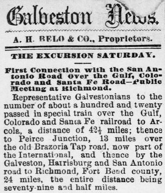
Right:
The lead story in the Galveston Daily News
of April 30, 1878 reported the first excursion train from Galveston to
Richmond via Arcola and Pierce Junction (which the reporter spelled "Peirce"
although the Post Office had changed it two years earlier.)
The
Brazos River was five miles west of Arcola, and bridging it became a significant
problem for the GC&SF, mostly for cash flow reasons. The major problem was that
Galveston County's majority ownership of the company raised novel legal
questions for investors assessing what would happen if the railroad defaulted on bond payments.
Suing the majority owner for
recovery would be impossible; Galveston County had sovereign immunity in both
state and Federal courts. This impacted investors' risk assessment and many banks and
lending institutions shied away from buying the company's bonds. By the fall of 1878, the
GC&SF lacked the
cash to finish the Brazos bridge which was the only remaining obstacle preventing service to
Richmond. To finish the bridge, the GC&SF advertised for proposals for a short-term loan of $250,000. They
only received one bid, from a private
syndicate led by GC&SF Treasurer George Sealy! The syndicate included several
other officers and members of the GC&SF Board of Directors, plus various
Galveston businessmen and companies. The loan would be for 90 days, and a key term of the syndicate's offer was that
the loan be secured by a Deed of Trust on the railroad's assets, overseen by an
independent Trustee.
GC&SF stockholders needed to approve taking the loan, but that issue was settled when the Galveston County Commissioners
approved. They had little choice since the railroad would otherwise go
bankrupt. The Commissioners subsequently agreed to sell the County's stock directly to Sealy's syndicate
for $10,000, literally pennies on the dollar compared to the $500,000 they paid for it. This eliminated the
legal uncertainties that had hampered the railroad's financial stability, but it
also ensured that company control remained in the hands of Galveston
businessmen whose interests were generally aligned with the County's. A
competitive stock sale -- or worse, a bankruptcy sale of the entire railroad --
could result in some other railroad acquiring control and then managing the
GC&SF (or dismantling it to eliminate competition) to the detriment of
Galveston's interests.
Despite the loan, the
GC&SF made little progress on the Brazos bridge; presumably much of the
funding went to pay outstanding construction bills. When the loan came due
after 90 days, the GC&SF was unable to make the required payment and went
into default. The Trustee forced a courthouse auction on April 15, 1879 which
was won for $200,000 by Sealy's syndicate. Since the syndicate owned two-thirds
of the outstanding shares of the GC&SF and most of its members were also private stockholders, the
syndicate effectively bought the railroad from itself (with the remaining
private stockholders getting nothing.) There was speculation that this had been
the plan all along, i.e. that GC&SF management had allowed the company to drift
into bankruptcy so the Directors could buy it at a greatly reduced price.
Regardless, the new GC&SF corporation was no longer encumbered by the prior
stock issue and was able to sell $540,000 in mortgage bonds. This provided the
cash to finish the Brazos bridge (in October, 1879) and fund additional construction to the
northwest.
In their initial route survey, the GC&SF had expected to serve downtown Richmond, likely sharing the
GH&SA depot for the convenience of connecting passengers. Coming out of
downtown, they planned a route that went west along the south side of the GH&SA
right-of-way (ROW). Three miles out of Richmond, the GC&SF would cross over the
GH&SA tracks and curve to the northwest toward Brenham.
This crossing, called San Antonio Junction for planning purposes, would also
host interchange tracks between the railroads. The major problem that remained
to be solved was actually getting a surveyed ROW into downtown. Richmond was on the
west bank of the Brazos and sat mostly south of the GH&SA ROW. The GC&SF's
Brazos River bridge was sixteen river-miles southeast of Richmond, hence they
were
approaching from the southeast; getting into downtown would
require a ROW through the heart of Richmond. The
GC&SF reportedly asked the city to provide the ROW, but city officials
declined. Perhaps it was due to the numerous residences and businesses that
would need to be bought out or condemned, an expensive and time-consuming
process. Or perhaps they were sufficiently satisfied with the rail service
they'd known for more than two decades that they didn't sense an urgency for the
GC&SF to serve downtown. Whatever the case, without a route
into downtown, the GC&SF had little choice but to pass south and west of Richmond,
approaching the GH&SA ROW nearly a mile west of the GH&SA depot, just
over two miles east of San Antonio Junction. [At this location, the railroads
might have considered adding a "depot track" to downtown, or perhaps a
connecting track to the GH&SA, either of which would have facilitated GC&SF
passenger trains going east to the depot and then backing out to return to the
GC&SF main line. No evidence has surfaced to indicate such an idea was ever
considered, which undoubtedly had its own set of issues.] The end result was
that the depot the GC&SF built to serve Richmond was a mile distant by city
streets from the GH&SA depot.
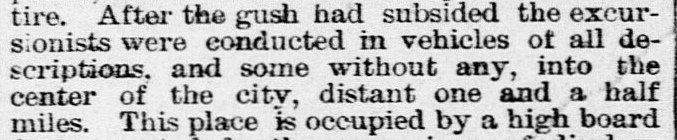
Foreseeing the difficulty for passengers to change trains at Richmond,
the railroads decided to establish scheduled connections at San Antonio
Junction where they had already agreed to have interchange tracks. Sharing a depot
there for connecting passengers allowed the railroads to help promote (and profit
from) the expected flow of passengers between Texas' two
largest cities, Galveston and San Antonio. Passengers originating or terminating
their trips at Richmond would simply use the depots in town. Before service began, the GC&SF renamed the crossing "Rosenberg Junction", in honor of former
GC&SF President Henry Rosenberg, a member of George Sealy's syndicate. It seems
unlikely that an isolated rail junction sitting out on the prairie three miles
from downtown Richmond would be named for a key member of
the GC&SF management team before service had even started unless the GC&SF
intended to develop a town around it. People began to settle in the vicinity of the
crossing, and by 1881, a Post Office had opened. The town's layout and
construction commenced in earnest in 1883 when the GC&SF bought 200 acres of
land adjacent to the crossing, much of it to the north between the tracks and
the river. At some point, "Junction" was dropped and the community simply became
Rosenberg.
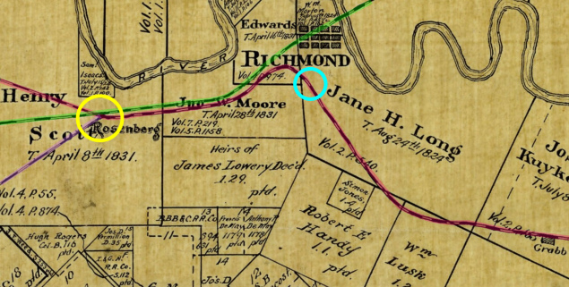 |
Left:
This 1892 Texas General Land Office map (hat tip, Ken Stavinoha) has been
annotated to show the GC&SF ROW (red highlight) crossing the GH&SA (green
highlight) at Rosenberg (yellow
circle.) By 1882,
Rosenberg had a true Union Depot serving the GC&SF, the GH&SA and the New York, Texas
& Mexican (NYT&M) Railway (purple highlight), which had completed a line from
Rosenberg to Victoria in 1882. The GC&SF depot for Richmond (blue circle) was
more than a mile from downtown, as mentioned (below) in this short excerpt taken from a
lengthy article published by the Galveston Daily
News
of October 19, 1879. The article was written by a correspondent on a special excursion train (of 600 people!) to Richmond that the GC&SF
operated from Galveston to promote its upcoming passenger service (which
commenced two months later.) The train had discharged its passengers at the
GC&SF station in Richmond, likely not much more than a simple platform as it had
only been a few days since the building materials arrived.
 |
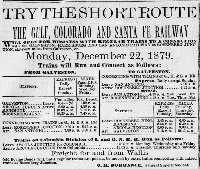 Right:
The
Galveston Daily News of December
21, 1879 carried this advertisement announcing GC&SF scheduled passenger service
to Richmond and Rosenberg Junction commencing the next day. Note the connections
for San Antonio via GH&SA trains at Rosenberg Junction, and the connections for
Columbia (not to be confused with Columbus) via I&GN trains at Arcola Junction.
Right:
The
Galveston Daily News of December
21, 1879 carried this advertisement announcing GC&SF scheduled passenger service
to Richmond and Rosenberg Junction commencing the next day. Note the connections
for San Antonio via GH&SA trains at Rosenberg Junction, and the connections for
Columbia (not to be confused with Columbus) via I&GN trains at Arcola Junction.
The ad mentions "Freight for and from
Wallis" to move by extra trains at Rosenberg. Wallis was the next town,
about sixteen miles northwest, in the narrow corridor between the Brazos and San
Bernard Rivers that had been identified by GC&SF route planners early on. It was named for GC&SF Director J. E. Wallis, who was also a member of Sealy's syndicate. As the ad makes clear, by the date of initial service to Rosenberg, tracks were already in service to Wallis for work trains. There was
an existing community there ("Bovine
Bend") with sufficient commerce potential that the GC&SF decided to show it as a viable service
point, even if not by regular trains.
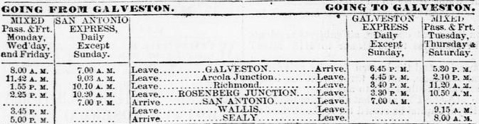
Below: Passenger service to Wallis and
Sealy, the next town farther north, commenced
January 16, 1880, less than a month after initial service to Richmond and
Rosenberg. This schedule in the
Galveston Daily News of January 15th
shows the GC&SF had begun using "Galveston Express" and "San
Antonio Express" to name its connecting service with the GH&SA.
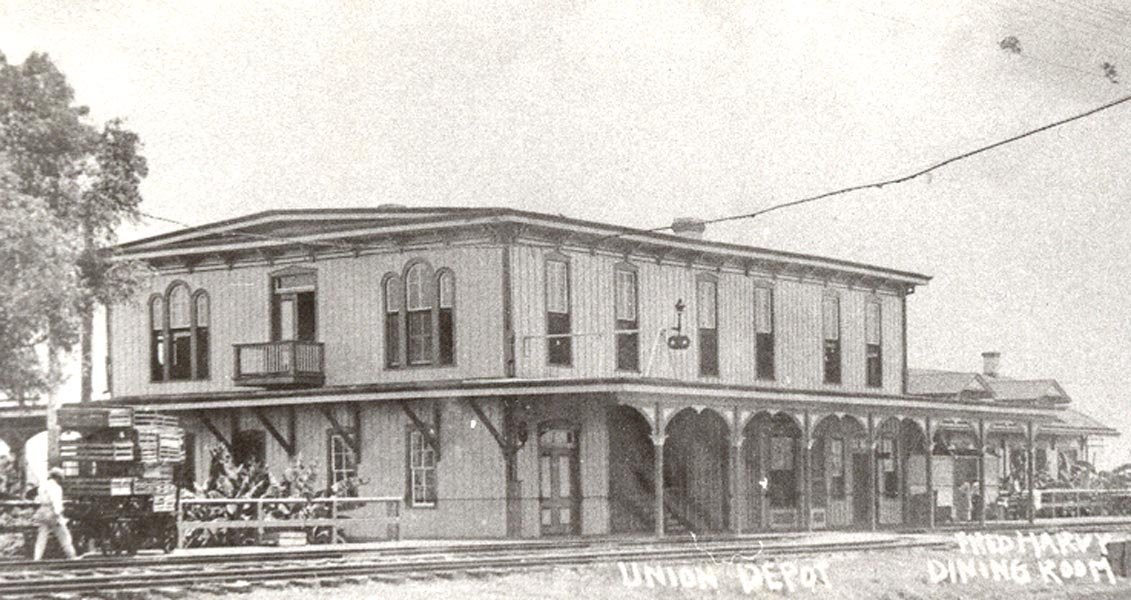
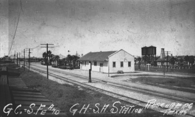
Above: This undated photo of Rosenberg
Union Station (Ken Stavinoa collection) faces northeast showing the southwest
corner of the depot. The tracks in the foreground and the train order signal
belong to the GC&SF, with Tower 17 roughly a quarter mile to the left (west).
The GH&SA tracks are on the other (north) side of the station. The Harvey House
restaurant that opened in 1899 is visible to the right of the station. The
street adjacent to the Harvey House on its far side (east) was 5th St., at least
in those days -- due to street renumbering several decades later, it is now 3rd
St. On the east side of that street, a new joint depot opened in 1917 and Union
Station was closed. The Harvey House appears to have continued operating until
closing c.1923.
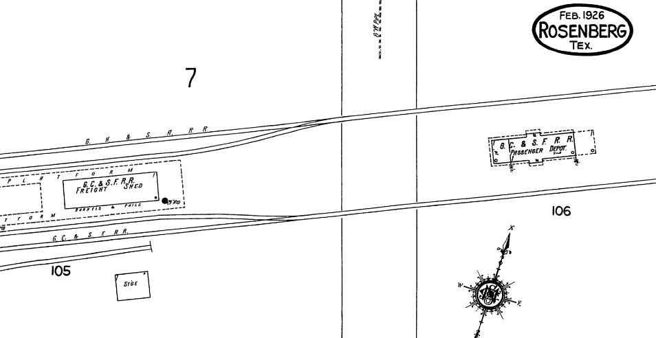
Below: This image from the 1926 Sanborn Fire
Insurance Co. map of Rosenberg shows the 1917 passenger depot sitting east of
5th St. (present day 3rd St.) between the GH&SA and GC&SF tracks. Although the cartographer
identifies it as the GC&SF depot, it served both railroads.
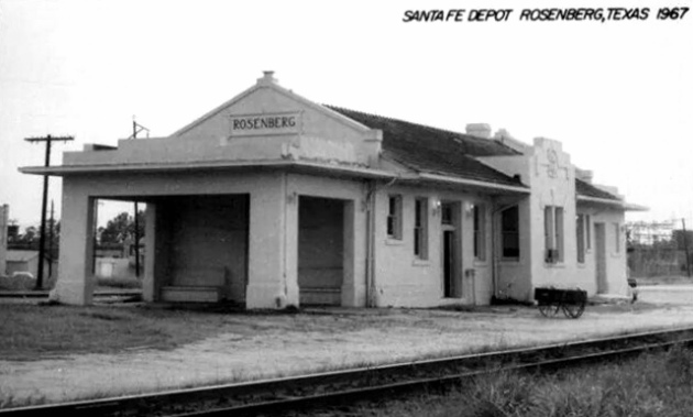
Above Left: The new joint
passenger station for Rosenberg opened in 1917 and survived
until 1980. (H. D. Connor Collection, 1967)
Above Right: The 1917 joint passenger station sits
amidst the palm trees (a tropical style park built by the GC&SF) in this undated photo of Rosenberg. Note
what appears to be a semaphore
signal rising above the trees. The white building in the foreground is the
Express Agency for shipping packages by train.
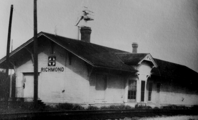
Above Left: The GC&SF eventually built a
standard depot at Richmond, apparently at or very close to the location that had
hosted the original 1879 structure.
Sometime between 1958 and 1970, this depot was removed. (Ken Stavinoha
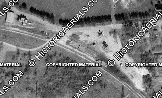
collection) Above Right: The
depot foundation remains visible in this 1970 aerial image. The road that
crosses the tracks to the left of the foundation is Austin St., a grade
crossing that remains intact on the west edge of Richmond. ((c) historicaerials.com)
The third railroad at Rosenberg was the New York, Texas
& Mexican (NYT&M) Railway, chartered in 1881 as part of a grand
plan to build a railroad from New York City to Mexico City. The enterprise was
organized by Italian financier Count Joseph Telferner. Work
began in Texas with construction of a 91-mile line from Rosenberg through
Wharton to Victoria.
It was completed in 1882, mostly built by laborers brought in from Italy (and
thus nicknamed "the Macaroni Line".) The NYT&M's plan was curtailed when
the railroad was acquired by SP in 1885, although it continued to operate under
its own name. In 1900, an NYT&M branch
line was built south from Wharton to Van Vleck to serve the rich agricultural
area of the lower Colorado River valley. In 1905, SP fully merged the NYT&M into
the GH&SA. Because the Macaroni Line branched off the Sunset Route a short
distance west of Rosenberg, the NYT&M was not officially associated with the
Tower 17 interlocker when it was authorized for operation by the Railroad Commission of Texas
(RCT) on July 23, 1903. The interlocker was a 27-function electric plant
manufactured by
the Taylor Signal Company.
The diamond at Tower 17 continues to see heavy traffic. The GH&SA
Sunset Route is now owned
by Union Pacific (UP) while the GC&SF line is part of Burlington Northern
Santa Fe (BNSF). During the UP/SP merger in the 1990s, Kansas City
Southern (KCS) obtained rights to operate on UP tracks between Beaumont and
Robstown, a vast distance that enabled KCS to
connect its Port Arthur - Kansas City main line with the Texas Mexican Railway
(of which KCS had controlling ownership) at Robstown. KCS' authorized route
through Rosenberg required its southbound trains coming out of Houston to continue west to Flatonia on UP's Sunset Route.
There, KCS trains turned south to Victoria and continued to Robstown
via Placedo. The Macaroni Line presented a route 61 miles shorter between Rosenberg and Victoria, but the
tracks had been out of service since 1986
(with 85 miles from Victoria to McHattie, near Rosenberg, formally abandoned in
1993-95.) In 2000, KCS was given the right to reestablish service over the
Macaroni Line if desired. After a 2004 study of the feasibility of
rehabilitating the route, construction commenced in 2007. Operations over the rebuilt line began in 2009 and continue today.
Tower 17 was the last traditional
manned interlocking tower in Texas. Tower 16 in Sherman and
Tower
47 in El Paso both closed in 2001 leaving Tower 17 as the last holdout until
it closed on February 10, 2004. Albeit somewhat non-traditional, the last
operational interlocking tower in Texas controls the lift bridge over Galveston Bay
(although it appears that this control system may no longer be referenced as
Tower 97.) Thanks to the Rosenberg Railroad Museum,
Tower 17 did not suffer the demise of so many such towers in Texas. It was
relocated to their museum site, just a few blocks from its historic home.

Above Left: James Starkey from Templeton, MA visited Tower 17
on November 30, 2000 and took this photograph of BNSF 722
in Warbonnet
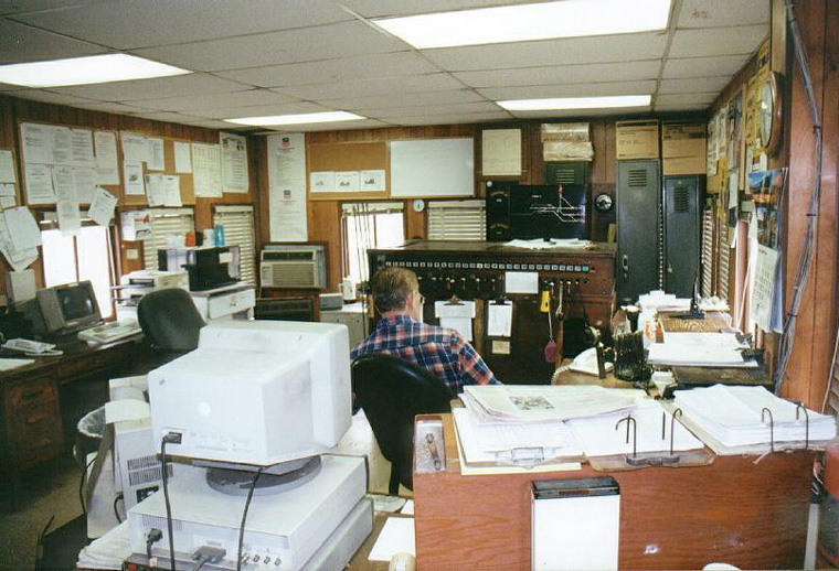
paint rolling past the tower. Above Right: interior photo of Tower 17 (James Starkey photo)
Below: Tower 17 now sits at the Rosenberg Railroad Museum (Jim King photo,
November 2012)


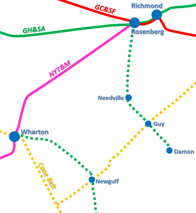 |
Above: In addition to the main lines built by the GH&SA, the GC&SF and the NYT&M, the GH&SA also built south from Rosenberg in 1918 to
serve mineral extraction at Damon Mound. Left:
The line to Damon came off the ex-NYT&M line, went eleven miles south to Needville,
then southeast five miles to cross the Cane Belt Railroad (a GC&SF property) at Guy, then six additional
miles to Damon. After SP abandoned the short Guy - Damon segment in 1944, the branch became known as the Guy Subdivision
and it survived another 42 years as an alternate
route to Victoria. This was feasible because SP's ex-NYT&M branch from Wharton to
Van Vleck passed through Newgulf, a town which had Cane Belt tracks from Guy.
Hence it was
feasible for SP trains coming east from Victoria on the ex-NYT&M to turn south at Wharton,
proceed to Newgulf, turn east on the Cane Belt to Guy, and turn back north on the Guy
Subdivision to Rosenberg. In both directions, this alternate route was valuable to SP whenever tracks between Rosenberg and Wharton were congested or blocked (e.g. a
derailment, or, as in 1950, when a bridge burned.) This alternate route was specifically identified in a
1936 agreement between SP and the Order of Railway Conductors which stated
"Movement over the Wharton Branch, Damon Branch, and over the Santa Fe will be
made only as the exigencies of the service require."
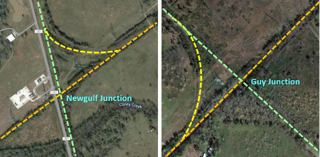
Below: The tracks
are
gone, but the junctions at Newgulf and Guy can be discerned from the tree
lines. Neither was interlocked.
 |
Historic Tower 17 to close in January
2004!
Bill Waldrop, Houston, 11/9/2003
I went to UP Tower 17 (Rosenberg)
today, and what we have long feared has happened. UP signal crews
are now installing a new interlocker control building that will
replace Tower 17, the last remaining operating tower in Texas.
The small metal control building is in, a microwave link is set-up,
and they are working quickly running wires, etc. According to a UP official I spoke with
about this, he stated the tentative date for the changeover is
the first week of January, 2004. The signal guys are going to have to
replace all switches (and possibly the signals as well) that are
controlled by the manned tower because they are not compatible
with the current computer control system. The tower will come under the direct
control of UP's Glidden Sub Dispatcher based in Spring. We are
not sure how the BNSF will have any control of their line crossing
UP at this tower, but I know their dispatcher sits very close
to the UP dispatcher in the Spring Dispatch Center, so I'm sure
it will be easily coordinated. The good news out of all this is the
fact that the tower will NOT be torn down! In fact, UP will be
moving it a few blocks east to the Rosenberg Railroad Museum,
where they have already measured for the concrete base, etc. I've heard different accounts about how
old this tower is and how long it has been in service...anywhere
from the late 1800's to the early 1900's. It still uses the original
equipment to control the switches and signals (manually pulled
levers by the operator on duty). We all knew this was coming for many
years, but reality has hit in the fact that it will happen very
soon. I hope everyone has their pictures of this last operating
tower in Texas, it's surely a classic, and it will be sorely missed.
It's the end of an era.
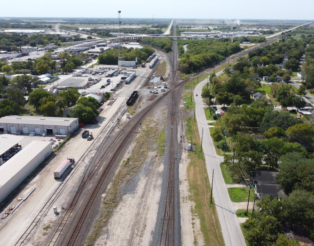
Above: Looking west from
Rosenberg down UP's Sunset Route toward Eagle Lake, the Tower 17 crossing is
just above the center of the image with white equipment cabinets and vehicles
sitting on the former tower site to the left of the diamond. The BNSF main line from Galveston enters the image at lower left and crosses the
UP tracks at the diamond, disappearing into the northwest horizon at upper right toward Wallis. Just beyond the diamond, a
lengthy siding begins along the Sunset
Route to the right of the main line. The KCS line to Victoria then splits off to the left, disappearing
into the southwestern horizon at upper left. (Abel Garcia photo, 2020)
Special thanks to Ken Stavinoha for his assistance
with material and research for the Tower 17 page!