
Below: This photo shows the TC tracks on the southwest side of the depot, possibly taken from the driveway of the garage noted above. (January 1, 1935, by H. F. Spivey, Santa Fe Railway Historical & Modeling Society collection)

A Crossing of the Texas Central Railway and the Gulf, Colorado & Santa Fe Railway
|
|
Left: Tower 50 at Morgan was
integrated into the union depot, a design similar to
McGregor farther south. The 1902 photo date is
inaccurate; the interlocking tower was not approved for construction
until 1903 and it did not become operational until 1904. Tracks of the
Gulf, Colorado & Santa Fe Railway are in the foreground. Those of the Texas
Central (TC) Railway pass between the tower and the garage in the
background at far left.
There appears to be a hotel behind the depot. (Mark Nerren
collection) Below: This photo shows the TC tracks on the southwest side of the depot, possibly taken from the driveway of the garage noted above. (January 1, 1935, by H. F. Spivey, Santa Fe Railway Historical & Modeling Society collection) |
The Houston & Texas Central (H&TC) Railway
was chartered to build north out of Houston toward the Red River.
Tracks had been laid through Hearne and Bremond
into Groesbeck
by the end of 1870. Bremond
was significant because it was the target of the Waco Tap Railroad which had been chartered with the intent
to "tap" the H&TC main line to bring rail service to
Waco. The
project was mostly dormant, but conveniently for the Waco Tap, H&TC's investors
had been looking at the prospect of building lengthy branch lines into the
Texas Panhandle. Waco was one obvious gateway in that direction, hence
negotiations ensued to see what might be done under the Tap's existing charter.
To convey H&TC's long range intent, a charter revision passed by the Texas
Legislature on August 6, 1870 established Waco & Northwestern (W&NW)
Railway as the new name for the Waco Tap. The branch from Bremond to Waco was completed for the W&NW by H&TC's construction forces in September, 1872.
The W&NW was formally bought by the H&TC in 1873 and then operated as a
subsidiary. By that time, the H&TC main line had reached
Denison and connected with the Missouri, Kansas
and Texas (MK&T, "Katy") Railway which had bridged the Red River
from Indian Territory (Oklahoma) into Texas.
The branch to Waco was not the first
one built by the H&TC. Before the Civil War, the H&TC had taken over the
Washington County Rail Road, a broad-gauge (66 in.) track out of
Brenham, and
completed it to the H&TC main line at Hempstead, bridging the Brazos River during construction
in 1861. Later, the Brenham branch was extended west to
Austin where the last
spike was driven on Christmas Day, 1871. The entire branch was converted to
standard gauge (56.5 in.) in 1877. For the towns along the main line and the branches
to Austin and Waco, the H&TC provided direct service to Houston which was
quickly developing as a transportation hub. Its port on Buffalo Bayou led to the
Gulf of Mexico and it had rail connections to
Galveston.
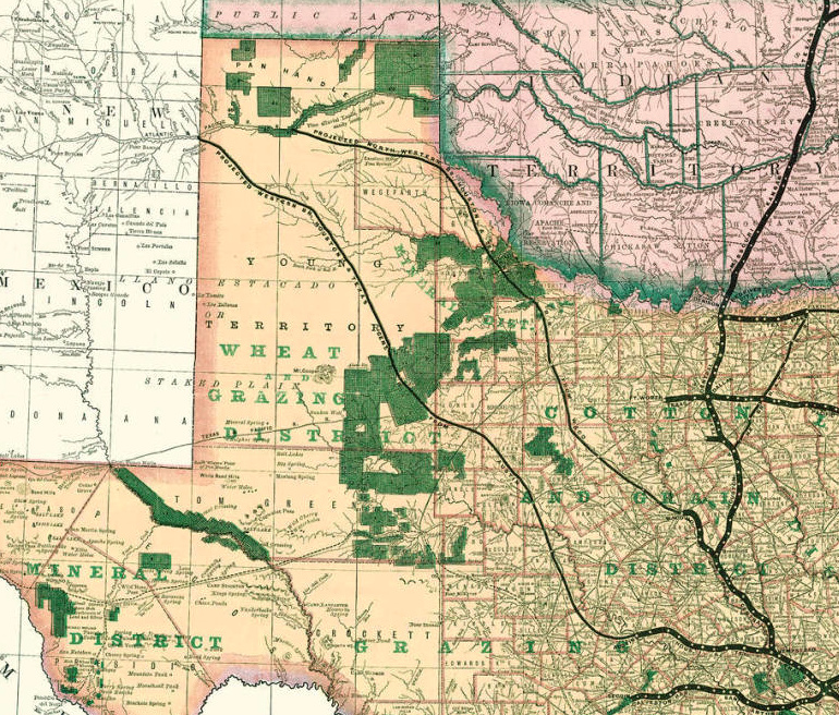 |
Left: The three thin black lines on this 1876
map of Texas railroads were H&TC's projections for two lengthy branches
running northwest into the Texas Panhandle and a branch to Paris running
northeast from the H&TC main line at Ennis. To the west,
the southern line was to build from Austin to the New Mexico border
where it would connect to the Atlantic & Pacific (A&P) Railroad. The
northern line out of Waco was to reach
the A&P at the Canadian River in the Texas Panhandle. Amarillo
was founded 18 miles south of the river a
decade after this map was created. H&TC's investors anticipated that both of the western branches would connect to the A&P, a company chartered by Congress to build a transcontinental route from Springfield, Missouri to the Pacific Ocean, generally along the 35th parallel. Eastern and western portions of the A&P were built, but for financial reasons, the central part of its planned route, including the Texas Panhandle, never materialized. Its western tracks became part of the Atchison, Topeka & Santa Fe Railway while its eastern tracks became part of the St. Louis & San Francisco Railway. The planned northern branch line to the Panhandle never made it that far and the branch out of Austin was never built. The Austin & Northwestern Railroad was chartered to build sixty miles from Austin to Burnet in 1882, but it was narrow gauge and was intended primarily to serve granite quarries. It was extended to Llano, but went no farther. (map courtesy of the Texas General Land Office) |
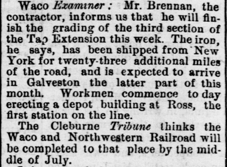  |
Left Top:
In late 1876, the H&TC began its northwest branch with an eleven-mile extension
of the W&NW from Waco to the community of Ross. On March 23, 1877, the
Galveston Daily News quoted a
Waco
Examiner report that the depot at Ross was under
construction. The article also carried a prediction by the Cleburne
Tribune that the W&NW extension would reach
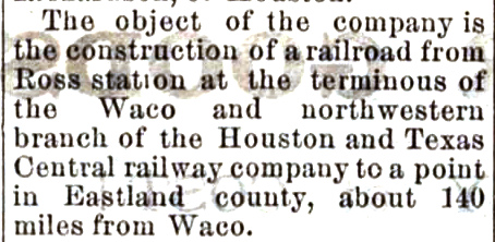
Cleburne within four months. Ross was named in honor of Lawrence Sullivan "Sul" Ross, a famous Texas Ranger and later a Confederate General during the Civil War. Ross settled in McLennan County during the post-war Reconstruction period, but whether he lived in the vicinity of his namesake community is undetermined. Ross would go on to become Governor of Texas in 1887 and President of what is now Texas A&M University in 1891. The H&TC main line between Houston and Denison had attracted the attention of Charles Morgan, owner of a major steamship company operating in the Gulf. Morgan recognized the need to acquire railroads to move goods and people in and out of the major ports servicing his steamship line. To this end, he organized Morgan's Louisiana and Texas Railway and Steamship Company and bought the H&TC in early 1877, naming his son-in-law, Charles Whitney, President. With Morgan and his family firmly in control, the H&TC and its investors refocused on the northwest extension, quickly discovering that its importance had increased for an unanticipated reason. Almost all of the land grant certificates awarded by the State of Texas for H&TC's main line construction needed to be surveyed and patented in the Panhandle; there was not enough state-owned land elsewhere to fulfill the grant. This simply reinforced the need for a northwest extension. Left Bottom: With the W&NW terminated at Ross, H&TC President Charles Whitney elected to form a separate investor group to build the remainder of the Panhandle branch under a new charter, the Texas Central (TC) Railway, filed on May 30, 1879 and reported a few days later by the Fort Worth Daily Democrat of June 6. Soon, construction trains were using the W&NW from Waco to Ross to move construction materials north. In addition to the northwest extension from Ross, the TC also built a branch off the H&TC main line at Ennis that went northeast toward Paris. The projected northwest extension from Austin to New Mexico was never built. |
| Work on the northwest extension out of Ross commenced
soon after the TC was chartered. Route planning had to account for crossing the
Brazos River which was only five miles west of Ross. The TC right-of-way (ROW)
went north and remained at least three miles east of the Brazos until it neared
the new town of Whitney, founded by the TC and named for H&TC President Charles
Whitney. The
Handbook of Texas asserts November 25, 1879 as the date town lots
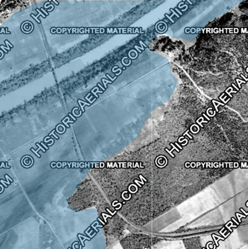
were sold at Whitney, a date backed by various newspaper accounts. The Handbook also claims that Whitney "...was established in 1876 when the Houston and Texas Central Railroad built a line through Hill County to Cleburne." This is simply untrue, and worse, it makes no sense. The town could not be "established" three years before town lots were sold. The TC construction north of Ross did not begin until 1879 and it did not continue to Cleburne, another mistake. There was never a rail line between Whitney and Cleburne (the prediction by the Cleburne Tribune was entirely wrong.) Approaching Whitney, the tracks curved west, passed through the center of the new town, and then turned slightly southwest for five miles toward the Brazos. Just before reaching the river, the tracks made a 90-degree curve and crossed the new bridge on a north-northwest heading. Presumably this unusual path was chosen for bridge engineering and cost reasons since it lowered the track elevation more than 40 feet before crossing the river on a 520 ft. bridge. Right: Nearing the Brazos, the TC tracks made a 90-degree turn and crossed the river on a north-northwest heading. The blue tint on this graphic shows the outline of what is now Lake Whitney superimposed on a 1938 aerial image ((c) historicaerials.com) of the river, the bridge and its approaches. Lake Whitney was authorized by an Act of Congress in 1944, primarily for flood control but also for hydroelectric power generation. Construction of the dam by the U. S. Army Corps of Engineers began in 1947 and was completed by March, 1951. A new bridge was built farther north to span the lake; the old bridge was dismantled. |
 |
  |
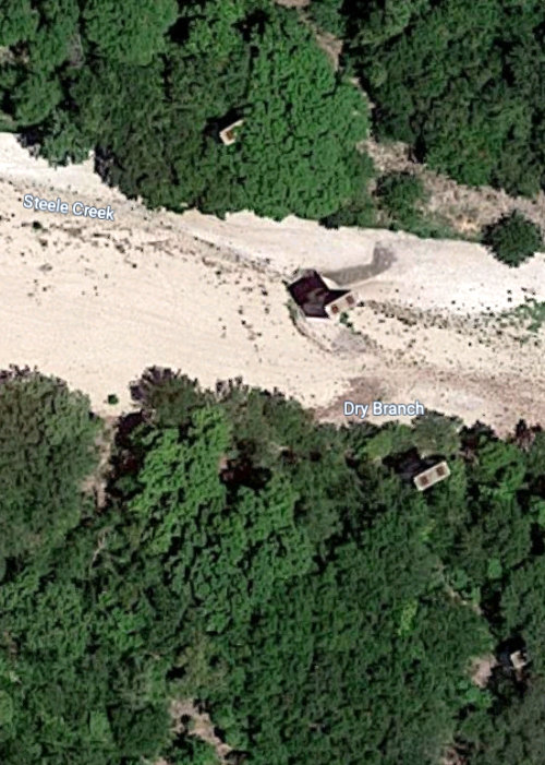
West of the Brazos River seventeen miles west-northwest of Whitney, the next town on the TC was named Morgan
but it briefly carried the name Steele's Creek, a local stream.
TC grading to the area had been completed in September, 1879, so the
scattered residents in the vicinity were aware of the coming
railroad. In August, 1879, they decided to form the town of Steele's
Creek and apply for a Post Office. In response to such
applications, the Post Office Department in Washington, DC would send
paperwork back to the requester to obtain specific geographic
information about the proposed site of the Post Office to determine how
mail routes might be altered to serve it. The paperwork would typically be
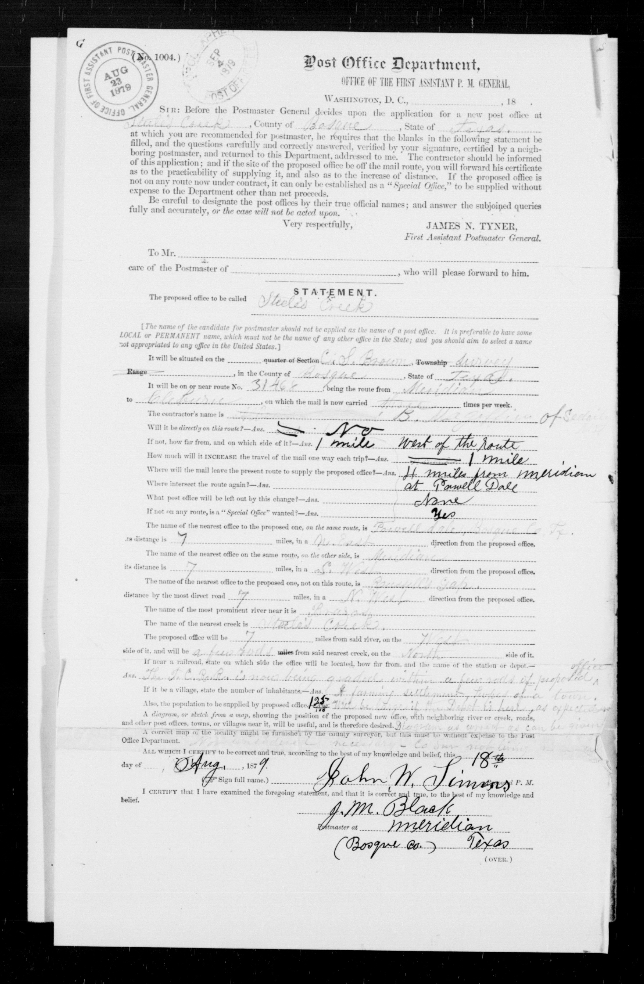
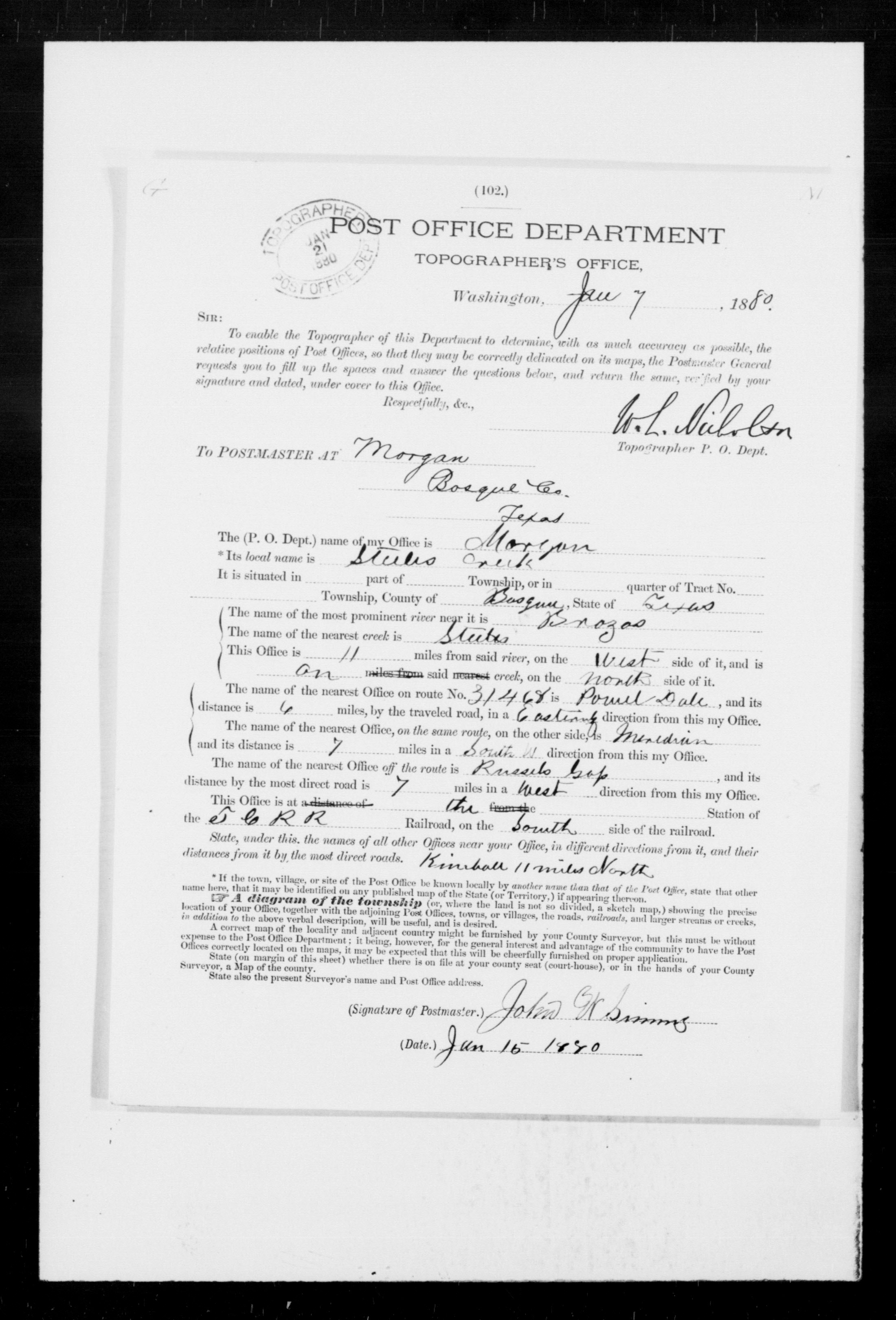
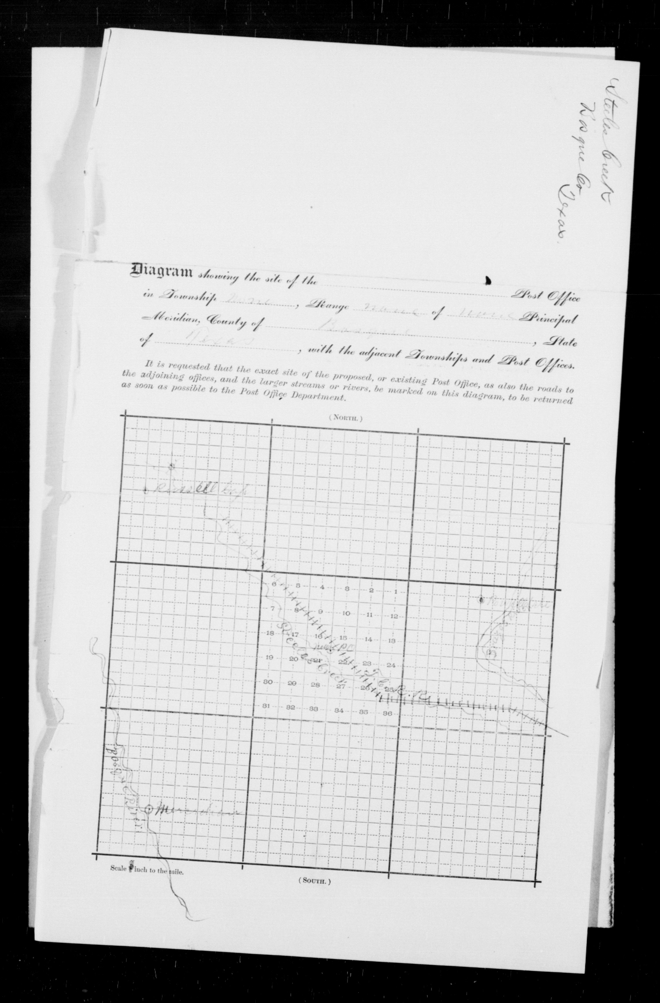
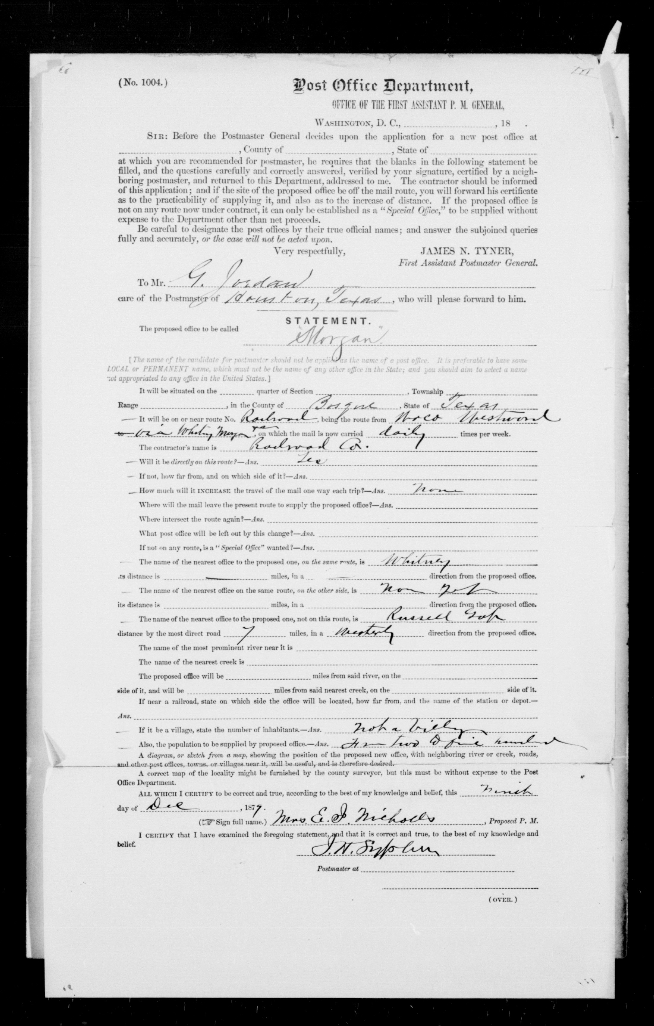
filled out by the proposed Postmaster who would sign it and send it back to the Post Office Department. Left Top: The response paperwork from Steele's Creek (click image to show full document) was signed on August 18, 1879. It was received in Washington DC on August 23, 1879 (5 days!) as noted by the stamp at upper left. [The purpose of the stamp on September 4, 1879 is unknown.] The Steele's Creek Post Office reportedly opened in December, 1879 but this date has not been independently verified. The document at left and its town sketch on the back are the only Steele's Creek site paperwork found in the National Archives. Left Bottom: On January 7, 1880, the Post Office Topographer's Department requested site data for a proposed Post Office for Morgan (click image for full document.) The reply from Morgan was sent on January 15 and the paperwork was received back in Washington on January 21 (stamp at upper left.) Note that the response identifies Morgan's "local name" as Steele's Creek. The asterisk beside the local name field leads to directions stating ... "If the town, village or site of the Post Office be known locally by another name than that of the Post Office, state that other name here." Steele's Creek was the name currently in use by locals (the TC's arrival was five months away) but this application is not a request to relocate or change the name of an existing Post Office. This lends credence to the possibility that a Steele's Creek Post Office was never granted, being superseded instead by the Morgan application. An earlier response document with site location information for a Morgan Post Office had been signed by the "Proposed P. M." (Postmaster) on December 8, 1879 and forwarded to the Post Office Department. Presumably its geographic details were deemed incomplete prompting the additional request by the Topographer's Office. Thus, no later than the first of December, 1879, the name "Morgan" had been contemplated. Most likely, it was the name assigned to the future town by the TC as part of its internal route planning. (National Archives) More than a year after the TC passed through Morgan, the town became the crossing point for the Gulf, Colorado & Santa Fe (GC&SF) Railway when that railroad reached the town in August, 1881 building north from Temple to Fort Worth. |
The Handbook of Texas asserts that Morgan was...
"...actually started as a result of the approach of the Texas Central Railroad. The population was sufficient in 1879 for a post office to be established in Steele's Creek. The intersection of the Gulf, Colorado and Santa Fe Railway with the Texas Central at the town made it a leading trade center, and the community changed its name to Morgan in honor of a Santa Fe stockholder and official, Thomas Morgan."
The GC&SF tracks didn't reach Morgan until August, 1881, sixteen
months after the TC had arrived. Thus it is not
credible that the "the
community" made the decision to change the name to Morgan to
honor an unknown
Santa Fe official. Postal records show that the name was in use by
someone in early December, 1879 when the request for a Morgan Post Office
was initiated a full twenty months before the GC&SF tracks reached town. At
the time, the GC&SF had only recently bridged the Brazos at Richmond
(October, 1879) and wouldn't begin service to the new town of
Rosenberg until December 22, 1879. The TC was using the name Morgan
in newspaper ads (see below) as early as February, 1880, eighteen
months before the GC&SF reached town. Searches for
"Thomas Morgan" as a Santa Fe official fail to develop any leads. The
name does not appear in the index of Tracks to the Sea (Earle B. Young,
1999 Texas A&M University Press) whereas numerous Santa Fe officials for whom
Texas towns were named are listed (e.g. Sealy,
Rosenberg, Moody, Blum, Kopperl, Bragg and
Somerville.)
Although the Post Office Department was
the ultimate arbiter of town names, the railroads had immense influence over the selection; they controlled their public timetables hence
they could decide by what name a town would be known in their service schedules.
For Morgan, the choice undoubtedly was made by the TC. Is it a simply a grand coincidence that the town bears the name of Charles
Whitney's father-in-law, Charles Morgan, the man who bought the H&TC and made
Charles Whitney its President? Is it plausible that the
TC's impending arrival caused the name Steele's Creek to be dropped
suddenly,
to be replaced by the name of an unknown
official for a different railroad that would not reach town for another sixteen months? Considering
the family and business relationships of Charles Whitney and his recently
deceased father-in-law (Charles Morgan had died May 8, 1878) is
it merely random happenstance that the next town on the TC after Whitney
was Morgan? Would Charles Whitney's wife have been happy if the
town had not been named for her father? (Umm...no.)
 Brenham Weekly Banner, September 12, 1879  Galveston Daily News, January 27, 1880  Galveston Daily News, February 15, 1880  Brenham Weekly Banner, March 26, 1880 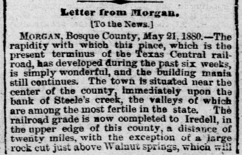 Galveston Daily News, May 28, 1880 |
Construction and Abandonment The Railroad Commission of Texas (RCT) was created by the Texas Legislature in 1891. One of RCT's early regulations was a requirement for railroads to report their annual track construction and abandonment activities including details of specific segments built or removed. Around 1980, Charles Zlatkovich gathered RCT's records plus information from other sources to publish a book detailing railroad construction and abandonment in Texas. Since RCT did not exist until 1891, records for track laying and dismantling prior to that year presumably reflect RCT's early efforts to gather this past information, supplemented by whatever additional sources Zlatkovich used. Drawing upon Zlatkovich's work, a table of railroad construction and abandonment in Texas through 2008 was published in 2011 by the Texas Transportation Institute (TTI) as an appendix to a report about policy and infrastructure issues pertaining to abandoned rail corridors in Texas. Although TTI's table is the best consolidated reference available, the errors and omissions in the RCT records compiled by Zlatkovich has led to mistakes in TTI's published data. An excellent example of these inaccuracies is the TC construction that passed through Morgan. The TTI table lists the segment as Ross to Albany, a distance of 178 miles, constructed in 1882. The GC&SF construction is listed as Temple to Fort Worth, 128 miles in 1881. Which railroad arrived in Morgan first? Contemporary newspaper articles tell the real story. The Brenham Weekly Banner of March 26, 1880 anticipates that the TC will arrive in Morgan in April since the tracks were within four miles of the town. This is confirmed by an article in the Galveston Daily News of May 28, 1880 discussing the "mania" of local construction that had occurred in Morgan during the six weeks since the TC's arrival. Work on the GC&SF line between Temple and Fort Worth actually began in November, 1880 southward from Fort Worth. Northward construction out of Temple started in early 1881, founding the new towns of Moody and Banks in late April or early May. [A Post Office was opened at Banks, but it was relocated and renamed for the new town of McGregor where the St. Louis Southwestern Railway crossed the GC&SF a year later.] GC&SF tracks reached Valley Mills in June, 1881 and Morgan two months later as confirmed by the Dallas Daily Herald of August 10, 1881. Work on the Brazos River bridge had been underway at least since March when a contractor advertised for quarrymen ("apply at Headquarters, Brazos River, 12 miles north of Morgan") in the Galveston Daily News of March 27, 1881. That newspaper's November 1, 1881 edition finally showed a GC&SF ad with a timetable "In Effect October 30, 1881" that served Cleburne. Although grading had been performed south from Fort Worth through Cleburne to the Brazos River, track-laying only proceeded northward. Full service between Temple and Fort Worth commenced New Year's Day, 1882. From the newspaper evidence, it is apparent that TC tracks reached Morgan in April, 1880 and the GC&SF tracks arrived there in August, 1881, precisely the opposite of what would be expected from TTI's table of construction and abandonment.  Morgan enjoyed growth in population and commerce spurred by its location at the crossing of two significant railroads. In 1900, it's population peaked but then began a slow decline, with 831 citizens as of 1910, down to 485 in 2000. It never became the leading town of Bosque County that some people had surely anticipated. |
 LaGrange Journal, November 24, 1880 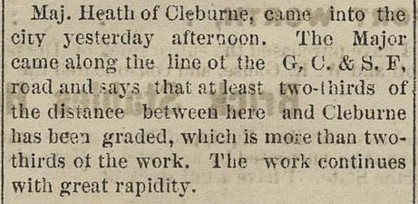 Ft. Worth Daily Democrat, January 25, 1881 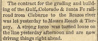 Fort Worth Daily Democrat, February 2, 1881  Galveston Daily News, March 27, 1881 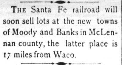 Brenham Daily Banner, May 18, 1881 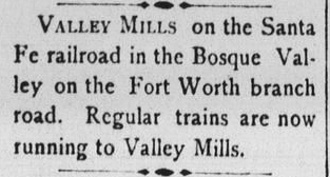 Brenham Daily Banner, June 24, 1881 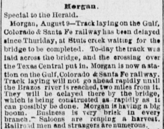 Dallas Daily Herald, August 10, 1881 |
When the GC&SF reached Morgan, it had only been in
existence for eight years, having been founded in
Galveston in 1873.
Starting with a new bridge
over Galveston Bay, construction had proceeded west to
Arcola in 1877, Rosenberg
in 1879, northwest to Brenham in 1880, and into Belton in January, 1881. Eight
miles shy of Belton, a construction camp named for the
railroad's chief engineer, Bernard Temple, became the branch point for
the line north to Fort Worth. As the tracks were
being extended westward beyond Belton to Lampasas (1882) and Brownwood (1885),
Temple was morphing into a significant city at the center of the GC&SF
network. The much larger Atchison, Topeka & Santa Fe (AT&SF) Railway acquired
the GC&SF in 1887 and operated it as a
wholly-owned subsidiary until finally merging it in 1965. The former GC&SF tracks through Temple
in all three directions (to Galveston, to Fort Worth and farther north, and
northwest to Coleman and beyond) remain in operational use, now owned by Burlington Northern Santa Fe (BNSF),
the
successor to AT&SF.
In 1901, the Texas Legislature passed a law assigning
RCT responsibility for regulating all crossings of two railroads (including those
that were grade-separated.) The law gave RCT the power
to specify where grade-separated crossings were required and to prioritize
locations for interlocker installations for crossings at grade. RCT also established procedures by
which new interlockers would gain final approval for operation, and they
specified information to be reported by the railroads annually for each
interlocker. On July 20, 1904, RCT authorized Tower 50 to commence operation
controlling the Santa Fe
/ TC grade crossing at Morgan.
Tower 50 first appears in RCT's table of active
interlockers dated October 31, 1904. RCT's published reports do not specify the
manufacturer of the interlocker at Morgan but they do state that it was
installed by Santa Fe. The Tower 50 interlocker was an electrical plant with 20
functions spread over 16 working levers (two thirds of its capacity of 24
levers.) By the end of 1930, the Morgan interlocker had only increased to 26
functions in RCT's list dated December 31, 1930 (after which RCT no longer
published this data.) Since the crossing had existed prior to 1901, the two
railroads were required by regulation to share the capital expense for the tower and
its
interlocking plant. They also shared the recurring costs for operating
the tower (e.g. staffing, utilities) and maintaining the facility and equipment. There is no
question that Tower 50 was a "Santa Fe tower". RCT records show Santa Fe
with operational responsibility, hence it was staffed by Santa Fe employees, and
they handled all tower and interlocker maintenance.
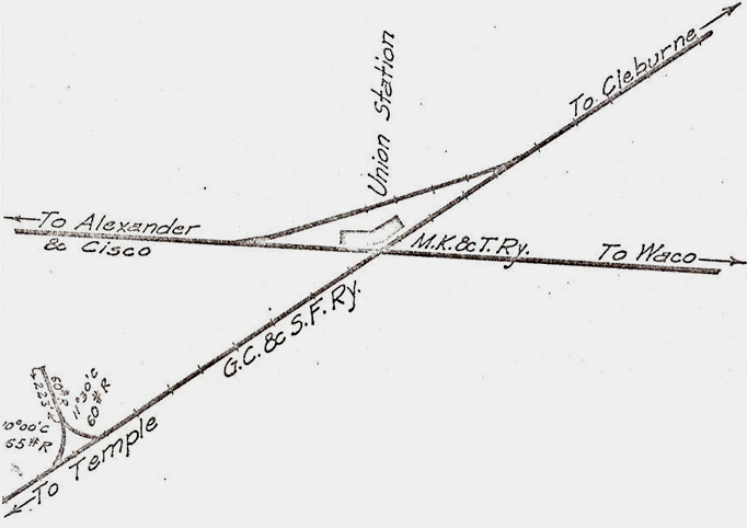 |
Left: This track chart of Morgan was created in
1915 by the Office of the Chief Engineer of the Katy Railroad (courtesy
of Ed Chambers.) The chart identifies the Katy ("M. K.& T. Ry.") as the
owner of the former TC tracks through Morgan; the Katy had acquired the
TC in 1910.
Below: Morgan's Union Depot was about a half mile
southeast of the town center on the north side
of the crossing with a connecting track located behind it. There were no homes or businesses
near the depot; a quarter-mile gravel road was built to reach
the depot from town. There is now a lengthy siding on the former Santa Fe line
through Morgan, hence two tracks are visible. (Google Earth, Dec. 2019
with annotations)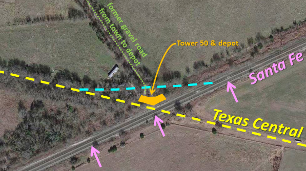 |
Beyond Morgan, the TC line toward the
Panhandle had crossed the Texas & Pacific Railway at Cisco
and then stopped 33 miles farther north at Albany. Newspaper articles pinpoint
December 20, 1881 as the date the first train rolled into Albany. The TC soon
discovered that operating a lengthy line through sparsely populated territory
was financially challenging. It entered receivership in April, 1885 and
continued to operate under court supervision. Six years later, the TC was sold
to a committee of bondholders. They in turn sold the northeast branch out of
Ennis to New York investor Hetty Green who
used it to create the Texas Midland Railroad. At the time, its tracks
terminated at the community of Roberts between Kaufman
and Greenville. The line was extended to Greenville
in August, 1894. The remaining branch to Albany was
deeded by the bondholders to a new Texas Central Railroad Company in
January, 1893. The new TC added tracks from Albany to Stamford (1900), Stamford
to Rotan (1907), and De Leon to Cross Plains (1911.) The TC also built a new
line from Ross to Waco in 1903, facilitating direct interchange with other railroads
in Waco rather than being dependent on the W&NW at Ross.
In 1910, the Katy acquired 90% of the stock of the TC. They did not, however,
take control of the company until May 1, 1914 when the TC was leased to the
Katy (technically, to its Texas-based subsidiary, the MK&T of Texas
chartered in
1891.) The lease enabled the Katy to comply with state law
regarding railroad ownership since the parent Katy corporation was not
headquartered in Texas. The
Texas Central name continued to be used, but "the Katy"
came into common parlance as operations continued for several decades.
Charles Wells
offers these recollections of riding Santa Fe passenger trains through Morgan in
the 1950s...(thanks, Charles!)
Trains 5 & 6, the Ranger, were the night trains I rode many times during the early 1950's to near their termination on May 29, 1960. My mother would put me on board #6 at Temple around 2:30 am bound for Fort Worth to visit my aunt and uncle and my two cousins. I always rode the first coach so I could clearly see in the baggage car with their lights on and the engines with its headlights and mars light on and the approaching signals. We would stop at Morgan just past the interlocking at the little platform and they would throw off mail and baggage and pick up the occasional passenger for Fort Worth or beyond. Sometimes made a double stop if they caught the sleeper on the rear. Morgan was a regular stop, both north and southbound for 5 & 6, and was always well patronized and quite full! Northbound at Morgan was around 4:30 am and southbound about 12:40 am and both trains often met at Temple. When I rode the Texas Chief, trains 15 & 16, they never stopped at Morgan though did seem to slow down over the Katy crossing. Never saw a Katy train there but did see some cars on the interchange track several times.
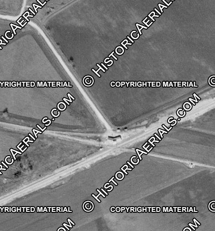
Right:
(1958 imagery (c) historicaerials.com.) As Charles' observations
indicate, the depot
remained operational at Morgan in the 1950s; aerial imagery from 1958
shows the depot and tower intact. The imagery also conveys the isolation
of the crossing southeast of town, surrounded by cultivated fields and
accessed only by a quarter-mile road. Unlike many small towns, there was
no "Front Street" in Morgan.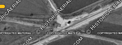 Left: 1965 aerial imagery (c) historicaerials.com The depot and tower are no longer present on 1965 imagery. The shadow near the crossing appears to be cast by the automatic interlocker cabinet that replaced Tower 50. A September, 1956 Employee Timetable (ETT) issued by the Katy identifies the Morgan crossing as controlled by an automatic interlocking even though the tower remains standing in 1958 imagery. Most likely, this automatic interlocking plant was housed in the tower / depot facility and was eventually replaced by the equipment cabinet visible in 1965 imagery, presumably due to the depot being razed. In 1967, almost all of the TC was abandoned, including the tracks through Morgan. About 25 miles of track between Gorman and Dublin was retained to serve the sizeable peanut industry located in those towns, served by railroads out of Dublin. Those tracks remain intact, now operated by the Fort Worth & Western Railroad. |
 |
 Above: Bricks line the former union depot platform adjacent to the BNSF main line. The Katy crossed at an oblique angle passing through the trees beyond the tracks. |
 Above: The Santa Fe crossed the Katy at approximately this location. This view down the BNSF track is to the northeast. The Katy grade to the east is visible in the gap through the trees. Below: A concrete signal base remains beside the Katy grade. The oblique angle of the crossing is apparent; the second BNSF locomotive is probably over the location of the diamond. (Tom Kline photos) 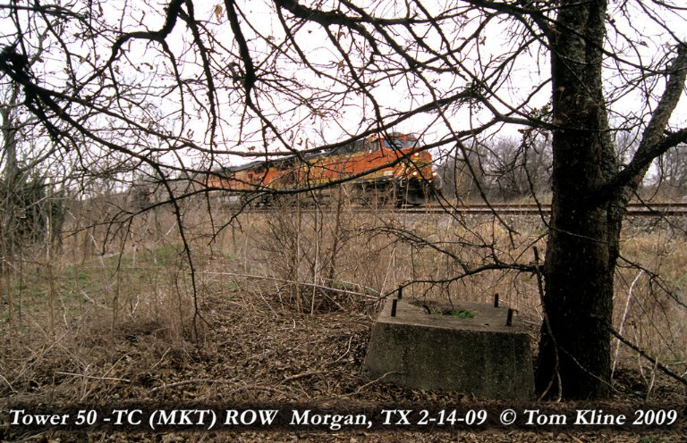 |
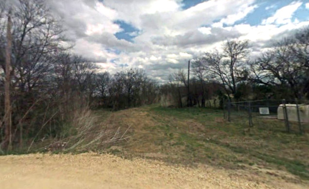
Above Left: A year before Tom's visit in 2009, Google
Street View captured this view of the turn-off onto the quarter-mile road to the crossing.
The road curves slightly to the right and disappears toward the crossing. There are no signals or
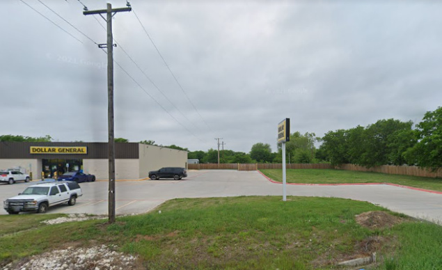
structures to be reached there, hence no apparent reason to maintain the road. Above Right:
These utility poles mark the path of the Katy / TC ROW looking west from FM
174 in the center of Morgan (Google Street View, April 2021.)
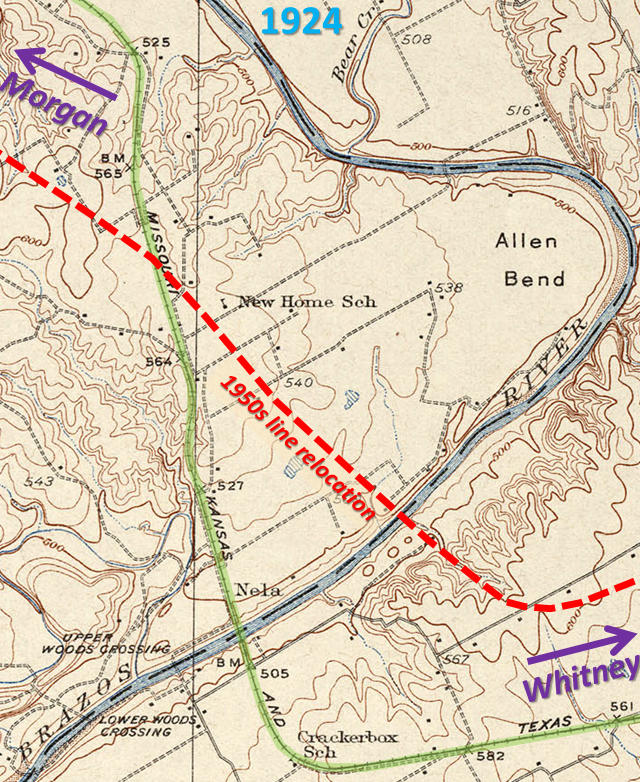 |
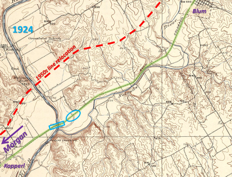
Left:
This 1924 USGS topographic map shows the Brazos River between Whitney and
Morgan. The original TC routing (green highlight) went five miles
south-southwest out of Whitney and then made a right-angle turn to cross
the river on a north-northwest heading. Proceeding farther north (and
off the map) on that same general heading, the route skirted the west
bank of the Brazos before finally turning due west to
approach Morgan
along the drainage of Steele's Creek. The proximity of the tracks to the
river undoubtedly caused disruptions during floods that were common on
the Brazos. It also meant that the entire line through this area had to
be relocated (red dashes) once the decision was made to build Lake
Whitney. When the Lake Whitney dam was completed in March, 1951, new bridges over the Brazos for both the Katy (TC) and Santa Fe were still under construction. This slowed the initial impoundment of the lake.  When the TC was abandoned in 1967, the Katy bridge over the Brazos that had been built c.1951 was reused as a highway bridge over Lake Whitney for County Roads 1713 and 1409. East of the lake, county roadway occupies about 3,100 ft. of ROW. West of the lake, a much longer section of ROW, about 2.5 miles, now carries the county road. The original TC grade can be seen on satellite imagery for most of its route between the connections where the new track departed from the original line. The east junction was on the west edge of the town of Whitney at 31 56 59N, 97 19 49W. The west junction is near Lakeside Village at 32 00 33N, 97 29 13W. Right: The new ROW (now CR 1409) crosses over the old ROW (green arrows) at 31 58 29N, 97 25 11W. (Google Earth, Dec. 2019) |
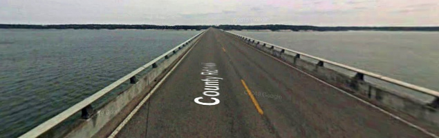
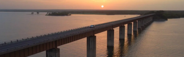
Above Left: Google Street View
from 2008 looking east across the Katy bridge that now carries FM 1409 / FM
1713. Above Right: drone shot
of the Katy bridge; click the image to see the drone video.

Above Left: Where the Katy
crossed Steele Creek south of Lakeside Village, these towering bridge piers were
left behind when the tracks were abandoned in 1967 (Mason Waldrep photo, August,
2023.) Above Right: This
Google Earth image from July, 2022 shows four of the piers. There is one
additional pier standing north of the creek. Historic aerial imagery from 1965 shows that the tracks
approached the bridge on large fills on both sides of the creek. The center pier
is
visible from Farm Road 56.
Right and Below: About twenty river-miles north
of where the Lake Whitney dam was built, Santa Fe's original Brazos
River bridge
was located across from the mouth of the Nolan River. Here, the river is
now ~ 1,000 ft. wide, still part of the lake. About
1,500 ft. beyond the north side of the bridge, the grade dropped low
enough that it would be inundated by the lake, hence Santa Fe built a
new bridge 7,000 ft. upstream, necessitating 13 miles of track
relocation (red dashes) and eliminating service to
the towns of Kopperl and Blum. The south connection was about 1.7
miles southwest of Kopperl at 32 03 22N, 97 31 25W. The north connection
was about 2.5 miles north of Blum at 32 10 36N, 97 23 09W. (USGS
1924 map/Google Earth)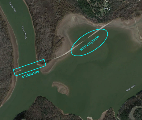 |
 |
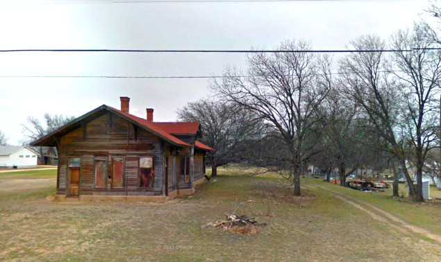
Above Left: The Santa Fe depot in Kopperl is abandoned
but still standing in this Google Street View of February, 2014. This view is
north along the Santa Fe ROW. Google Street View from March, 2025 confirms it is
still standing.
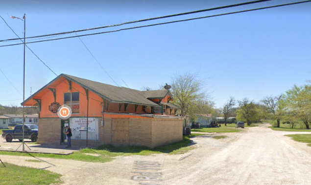
Above
Right: The Santa Fe depot in Blum was repurposed as the Redneck Grill and Bar, in business for several years. This view is south along the Santa Fe ROW.
The building remained standing as of March, 2023 but the business appears to be
closed. (Google Street
View, March 2021)