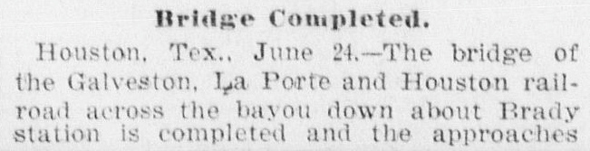
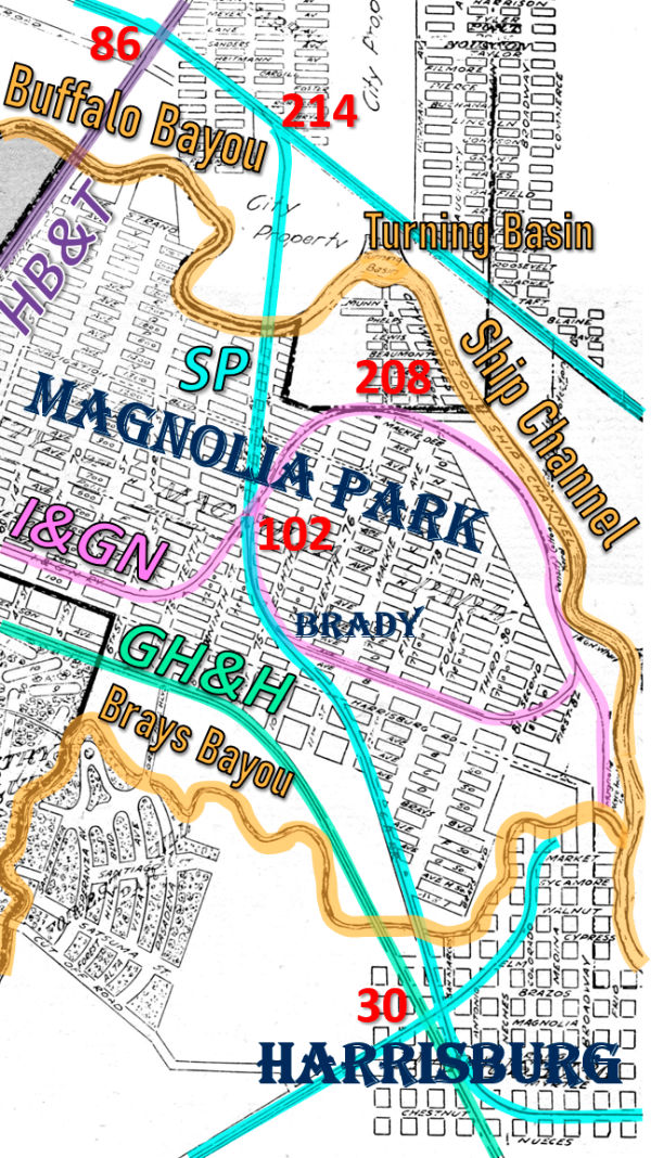
Texas Railroad History - Towers 102 and 208 - Houston (Magnolia Park)
Two Interlockers Supporting the Port
of Houston in Magnolia Park

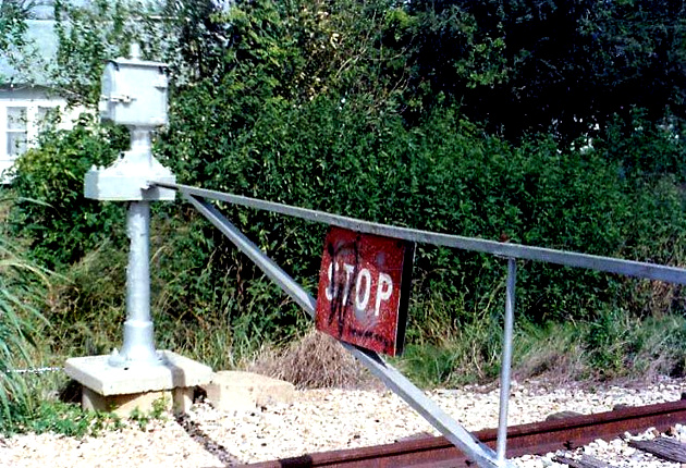
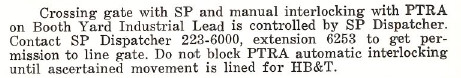
Above: Kenneth Anthony took
these two (undated) photos of the gate at Tower 102 that replaced an earlier cabin
interlocker. The gate was normally closed across the Southern Pacific (SP)
line, allowing continuous movements on the Houston Belt & Terminal (HB&T)
tracks known as the Booth Yard Industrial Lead. When closed and latched, trains on the HB&T track would
encounter a PROCEED
signal before reaching the crossing indicating the gate was open to them. When a
SP train needed to cross, the gate would be reversed, swung across the HB&T
track to allow the SP train to proceed. This required unlatching the gate which
produced a STOP signal to any approaching HB&T trains warning them to
anticipate a closed gate ahead. Gates provided a simple manual control system
for tracks that were lightly used, normally positioned to allow unrestricted
movements on the busier (HB&T) track. However, very few gates in Texas are
believed
to have been connected to signals; Tower 102 was one of them.
John Thomas Brady (sometimes incorrectly referenced as
Thomas M. Brady) was 26 years old when he arrived in Houston in 1856. Born in
Maryland and educated as an attorney, Brady settled at Harrisburg
near Buffalo Bayou and opened a law practice. Seeing steamships and
barges on Buffalo Bayou on a regular basis no doubt influenced his thinking that
it might one day become a more substantial transportation artery for vessels
operating in the Gulf of Mexico. Attempting to capitalize on this vision in
1866, Brady bought two thousand acres of land along the south bank of Buffalo Bayou, north of Harrisburg,
a few miles east of downtown Houston. Brady and other investors established two companies, the
New Houston City Company and the Texas
Transportation Company (TTC) to develop his property and build a rail line
to serve it.
Brady's timing was poor; the slow economic
recovery after the Civil War left investors leery of funding these
ventures. Very little construction was ever accomplished, perhaps in
part because Brady had been elected to the Texas Legislature and was
focused on his leadership duties in Austin
(including strong advocacy of railroads.) By 1876,
a controlling interest in the TTC had been acquired by Charles Morgan, owner
of a large steamship business that dominated shipping in the Gulf of
Mexico. Morgan wanted the TTC for its charter so he could build a rail
line along the north bank of Buffalo Bayou without the delay of
petitioning the Legislature (which met only in odd-numbered years) to grant a
new charter. Morgan's objective was to connect downtown Houston with
his new port of Clinton. He had recently paid to have a channel dredged
from Clinton to the Gulf, but he needed a railroad to serve the land
side of the port. The TTC opened tracks to Clinton from near downtown
Houston in late 1876; much of the right-of-way (ROW) remains in use
today. The starting point was the confluence of White Oak Bayou
and Buffalo Bayou,
commonly known as Allen's
Landing, the site of the original founding of the City of Houston. The port
of Clinton was on the north bank of the bayou opposite Harrisburg, near
the mouth of Sims Bayou. The town
of Galena
Park now occupies the site of Clinton.
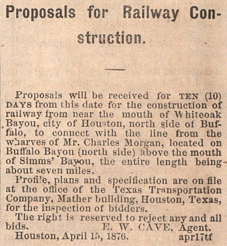
Right: The Age
(Houston) newspaper of May 22, 1876 carried this item soliciting
proposals to build the TTC rail line along the north bank of Buffalo
Bayou.
After Morgan's death in 1878, his Louisiana and Texas
steamship and rail operations were acquired and merged
into the Southern Pacific (SP) railroad in the 1880s. The TTC tracks
were combined with a subsidiary of SP, the Galveston, Harrisburg & San Antonio
(GH&SA) Railway, which SP had leased (and subsequently acquired) about
the same time. The GH&SA had started at Harrisburg in 1851 as the Buffalo Bayou, Brazos and
Colorado Railway, the first railroad in Texas and one that had long been
involved with shipping on Buffalo Bayou. Later, the TTC
tracks were transferred to another SP subsidiary, the Texas & New Orleans (T&NO) Railroad. |
 |
When Brady's New Houston City
Company did not succeed, he founded the Magnolia Park Company to develop his land. In
1890, he established the Magnolia Park community on 1,374 acres and built a
large amusement area, Magnolia Park, along the south bank of
Buffalo Bayou at Constitution Bend (named for the site where the
steamboat Constitution famously turned around in 1837 after navigating
up Buffalo Bayou, reportedly as a publicity measure for the new town of
Houston.) Brady planned a railroad that would
ferry passengers between downtown Houston and Magnolia Park, and support future industries along the
south bank of the waterway. To this end, he chartered
the Houston Belt & Magnolia Park (HB&MP) Railway on April 2, 1889. The
name captured the dual purpose of the railroad -- function as a "belt" railroad
interconnecting other main lines while carrying passengers to and from Magnolia
Park. The
charter specified that the railroad would be "...located so that it or any part
of it may be used as a belt or connecting line."
Brady's
vision of an integrated rail-served port along Buffalo Bayou was prescient, but
once again, his timing was poor. The industries that used Buffalo Bayou shipping
remained on the north side of the bayou, not the south side near the HB&MP.
The railroad sold passenger excursions to Magnolia Park from Houston but the
fare volume was insufficient to sustain the railroad; it went into receivership
in 1891. Brady died from a stroke in June, 1890, and the courts and
his heirs sorted out his holdings over many years.
The HB&MP's
construction is not listed in the official records of the
Railroad
Commission of Texas (RCT.) In the definitive reference A History of the Texas Railroads (St.
Clair Publishing, 1941)
author S. G. Reed says that in 1890, the HB&MP "...built six miles of track from Fannin
St. eastward on Commerce Avenue through Magnolia Park to Constitution Bend on
Buffalo Bayou." Reed's description measures a total distance of
approximately five miles. However, an 1891 "Bird's-Eye View" map of Houston shows that
where the line curved northeast toward the park, a spur continued east into
the residential area Brady was developing, likely accounting for the remainder of Reed's assertion of six miles of construction.
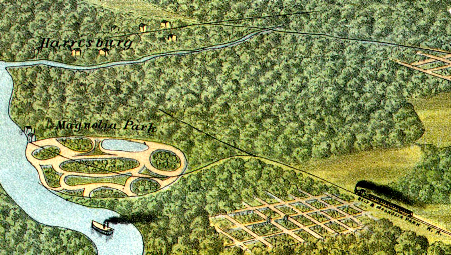 |
Left: This image is extracted
from the 1891 "Bird's-Eye View" drawing of Houston. It faces southeast,
with Buffalo Bayou at left flowing east toward Galveston. The town of
Harrisburg is depicted along Buffalo Bayou south of the mouth of Brays
Bayou. An HB&MP locomotive is shown moving eastward, away from downtown
Houston toward a junction where the main line curves to the northeast to
reach Magnolia Park. A rail spur continues east from
the junction, terminating in the area Brady planned to develop as a residential
community. (Library of Congress
image)
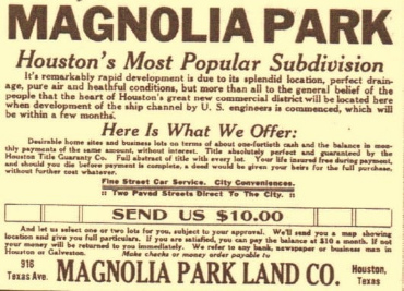
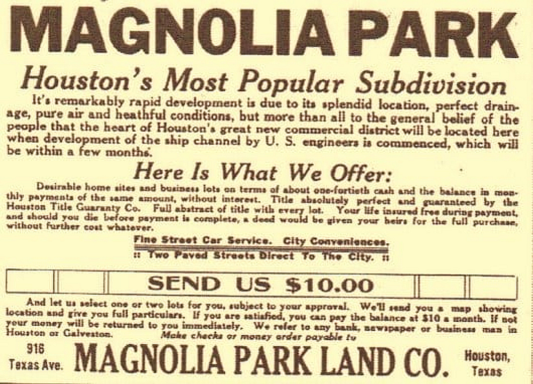
Above: c.1890 ad
(click to enlarge) offering lots for $10 per month (Margaret E. Young
collection) |
In receivership, the HB&MP faced lawsuits from the city of Houston and other property
owners claiming that it was not compliant with the ordinances that had granted its ROW. In particular, the city claimed
it had only authorized an electric rail line suitable for urban passenger service,
not the steam locomotives HB&MP operated. The HB&MP countered
that the ordinance allowed "...electricity, or such other power as will not
necessarily obstruct the use of said streets by the public...", and that
steam was in common use and met the criteria. As litigation proceeded, the Receiver
made arrangements to allow the International & Great Northern (I&GN) Railroad to
lease portions of the HB&MP for car storage, providing a small but steady
income. In 1894, the Receiver got a better offer; the Galveston, La Porte &
Houston (GL&H) Railway proposed to lease four miles of the HB&MP's track to
reach downtown Houston. As Reed explains, the lease gave the HB&MP "...a
mileage prorate of all revenue. This enabled the Receiver to keep the road
alive...".
The GL&H did not yet officially exist. It was the
La
Porte, Houston and Northern Railroad and it was in the process of getting the
legal arrangements in place to change its name. Its plan was to consolidate various rail lines
into a continuous route
between Houston and Galveston, building new tracks where necessary.
Approval of the GL&H's plan was
signed into Texas law on January 23, 1895 as Senate Bill 35, Chapter 7, subtitled
"An act to authorize the La Porte, Houston and Northern Railroad Company to
purchase and acquire and consolidate with it, all the property, rights and
franchises of the North Galveston, Houston and Kansas City Railroad Company and
the Houston Belt and Magnolia Park Railway Company, and to change its corporate
name." The name change to GL&H proceeded immediately with a new
charter dated January 30, 1895. The purchase of the North Galveston, Houston and
Kansas City Railroad Company was completed a month later. Although authorized to
do so, the GL&H did not purchase the HB&MP, choosing instead to lease four miles
of track into downtown Houston. With this accomplished, the GL&H began building tracks to
fill in the gaps between Houston and Galveston.
The GL&H's goal was to
compete in the Houston - Galveston market, capitalizing on
the new bridge it was building onto Galveston Island. Two such bridges
already existed; one was owned by the Galveston, Houston & Henderson (GH&H)
Railroad, a component of rail baron Jay Gould's empire leased to another Gould
property, the I&GN. The other Galveston bridge belonged to the
Gulf, Colorado &
Santa Fe Railway, a subsidiary of the Atchison, Topeka & Santa Fe Railway,
a major competitor to SP in the southwestern U.S. The GL&H wanted to build a
railroad that would be attractive to SP, taking advantage of an odd situation --
SP was one of the two largest railroad systems in Texas
(the other was the I&GN)
but it did not serve Galveston, the largest port in Texas. In early 1896, before the Galveston bridge was finished, the GL&H filed for bankruptcy protection on
January 7, having exhausted its capital in less than a year.
The District
Court appointed Receivers to take control of the GL&H, and it selected an
independent Master to review the financial situation and make recommendations. A
hearing was held on January 20, 1896, and three days later, the Master reported
to the Court that approximately $300,000 was needed to make the GL&H a viable
competitor for Houston - Galveston traffic. The Court approved the Master's
report and authorized the GL&H Receivers to borrow money by issuing Receiver
Certificates for a total not to exceed $250,000. With the authority granted by
the Court, the Receivers proceeded to hire L. J. Smith, a Kansas City
construction firm, to perform much of the work, including completion of the
Galveston Island bridge and construction of a new bridge over Buffalo Bayou at
Magnolia Park. Smith had been the original contractor for the GL&H.
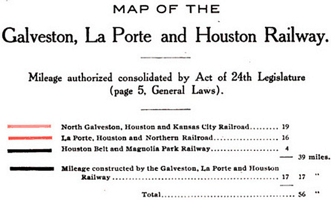
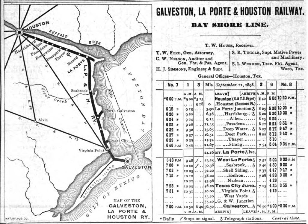
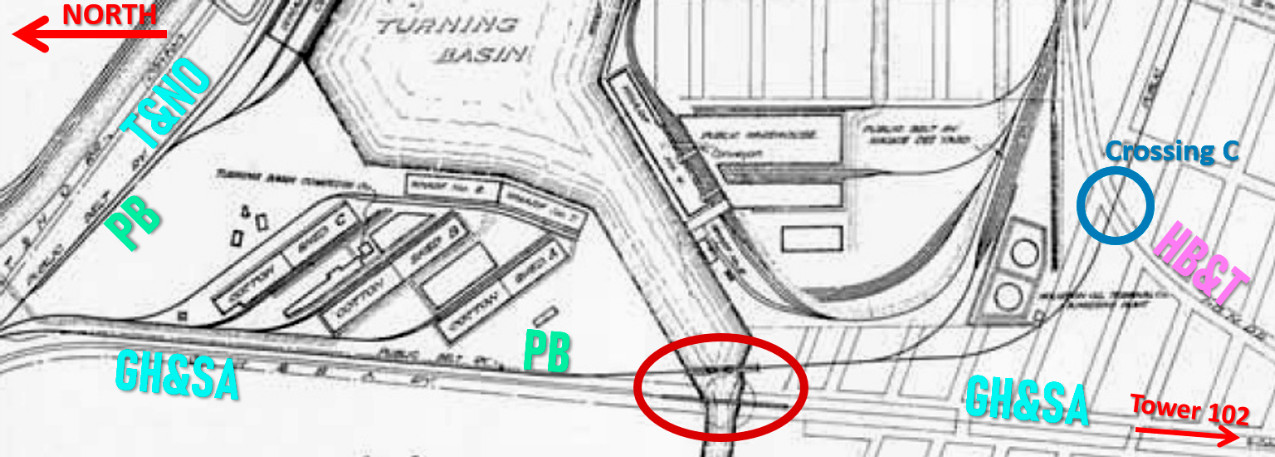
Above: This map appears in
the book Railroad Consolidations in
Texas 1891 - 1903 by Joseph Draper Sayers published in 1903.
It illustrates how the GL&H was formed and shows that its final segment into Houston
was from Brady on
the HB&MP.
The above map shows the HB&MP providing four miles of track for the GL&H from
Brady to Houston.
Because the GL&H freight depot was on the north side of
Buffalo Bayou, the GL&H
did not need to
use the entire HB&MP line from Brady into downtown.
Instead, its trains turned north near the intersection of Commerce and Hutchins
Street to take a rail bridge shared by SP and other railroads over Buffalo Bayou
to reach both its freight depot
and the passenger depot it used, SP's Grand Central Station.
Backtracking from the intersection of Commerce and Hutchins St., it's about 3.5
miles to HB&MP Junction where the main line curved northeast toward the
amusement park and the spur continued east into a residential area. A half mile
farther east on the spur brings the total distance to four miles near the
intersection of 75th St. and Avenue B. This was Brady, where the GL&H
tracks from Harrisburg made the connection to the HB&MP.
Reed asserts that the HB&MP's lease
to the GL&H was "...four miles of its track from Brady St. to
Fannin St. ..." but Reed surely meant Brady instead of
Brady St., which was halfway to downtown from Brady. The GL&H would have
had no means of
reaching Brady St. without using the HB&MP tracks from Brady. Also, the GL&H did not need to operate all the way to Fannin St. Four miles of track west from
Brady
was precisely enough to reach the rail junction near Commerce and Hutchins that led to the
Buffalo Bayou bridge. That the HB&MP ROW passed
through Brady but also operated for about 1200 ft. on Brady St.
appears to have led to the confusion.
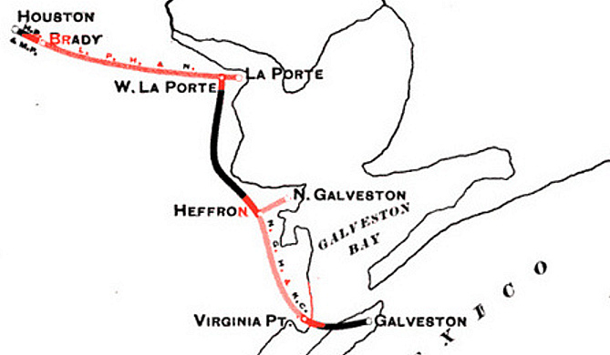
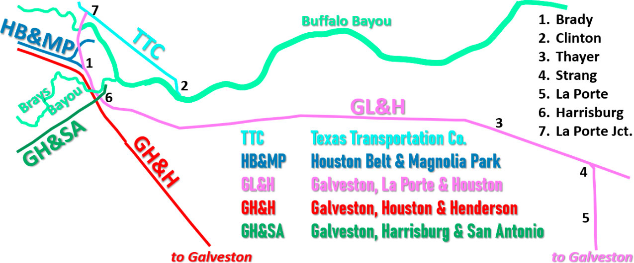
Right: This notional map shows the railroads between
Houston and La Porte that existed in 1895-96 when the consolidation of the
GL&H took place.
Below:
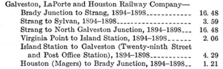
A 1932 ICC Valuation Report contained this synopsis of GL&H
construction, not including predecessors and acquisitions. The
distances appear precise, but the generic date range of 1894-1898
doesn't convey useful information.
 |
 |
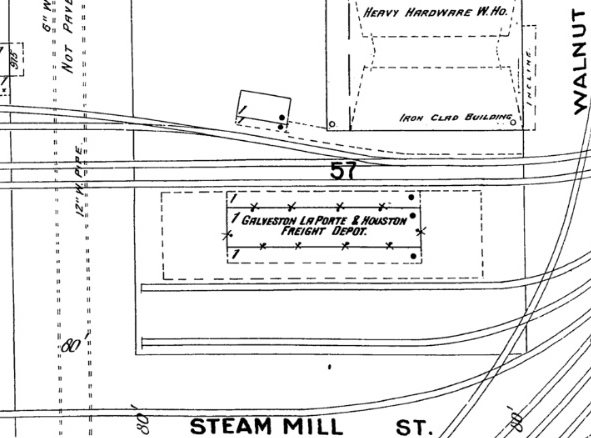
Right: The
GL&H freight depot was north of Buffalo Bayou near the intersection of
Steam Mill St. and Walnut St., about 500 ft. northeast of Bonner's Point, the future
site of Tower 108. Both streets still exist
but no longer intersect.
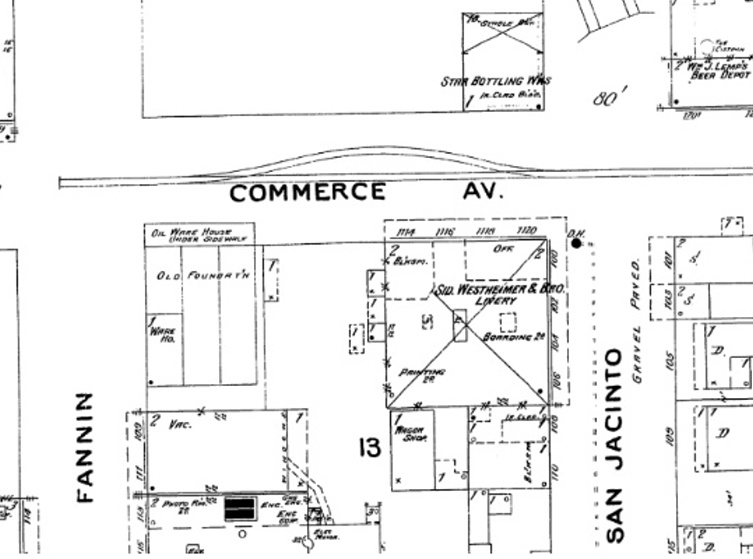
Far Right: The HB&MP tracks ended literally in the center of the
intersection of Fannin and Commerce in downtown Houston, without a wye or a depot in sight
(not counting "Wm. J. Lemp's Beer Depot" at the northeast corner of Commerce
and San Jacinto.)
(both images, 1896 Sanborn Fire Insurance map of
Houston) |
 |
 |
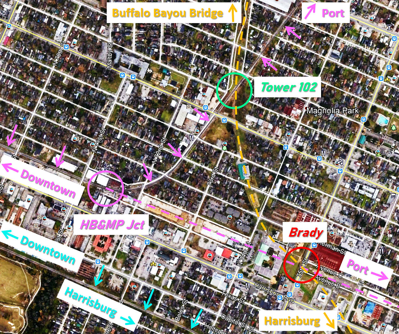 |
Left:
This annotated Google Earth image shows the rail connections and crossings in
Magnolia Park, with dashed lines used for tracks that are no longer intact and
pink arrows for tracks that continue to use the HB&MP ROW. The red circle
identifies the location of Brady (also called Brady Station and Brady Junction)
which may literally have been John T. Brady's homestead at some point in time.
It is where the GL&H's construction (orange dashes) north from Harrisburg intersected
the HB&MP spur (pink dashes.) The GL&H did not stop at Brady; its
construction continued north to cross the HB&MP at the future Tower 102
(green circle) as it headed toward the planned bridge over Buffalo Bayou.
At some point, the spur
at Brady was extended east to Buffalo Bayou providing another route to the Port of Houston. East of
75th St., the current alignment of Ave. B has an unusual shift of 70
feet to the north compared to farther west. This may be a tell-tale sign
that it was built atop the HB&MP ROW
after the demise of the spur's extension. The resolution of aerial imagery from 1930
is insufficient to show spur tracks east of Brady but does show that the spur ROW began
a slow curve to the northeast where Ave. B intersects
79th St. The spur reached the port near the east end of Ave. F, but the rail
connections it made there are undetermined.
After the demise
of the HB&MP, its tracks to the Magnolia Park amusement area northeast of
Tower 102 remained valuable for
servicing new industries along the south bank of Buffalo Bayou.
The former GH&H
tracks are marked with blue arrows in the lower
left quadrant of the image, now owned by Union Pacific (UP.) Coming out of
downtown, they pass through Harrisburg and continue to Galveston. |
RCT records show two construction activities by the GL&H
in 1895:
between La Porte and a location "0.5 mi. E. of Thayer", a distance of
5.76 miles, and 1.7 miles between
Harrisburg and Brady. Both of these activities were cited in a short article
about the GL&H in the industry periodical Railway
Review in 1895. The article mentions that "Track-laying between
Thayer and La Porte is now in progress. The contract let to L. J. Smith of
Kansas City, mentioned last week, calls for the construction of two miles of
road between Magnolia Park and Harrisburg, including a bridge over Bray's
Bayou..." The 1895 construction consolidated tracks and built missing
segments between Harrisburg and Galveston, and also built tracks from Harrisburg
to Brady. The track construction to Brady continued north toward the
site of the planned Buffalo Bayou bridge. From the south
bank of the GL&H Brays Bayou bridge to the north bank of the GL&H Buffalo Bayou
bridge is approximately 1.92 miles, a distance that fits with "...the construction of two miles of road
between Magnolia Park and Harrisburg, including a bridge over Bray's Bayou...".
The Master's plan allowed construction of a new bridge over Buffalo Bayou near
Constitution Bend which is now the Turning Basin of the Houston Ship Channel. There is
no doubt that the GL&H's effort to build to the north side of Buffalo Bayou was
a result of discussions with SP which owned several railroads
serving industries
there. SP wanted a route -- preferably its own -- for
those railroads to reach Galveston efficiently. If SP could use the GL&H's three major bridges -- over Galveston Bay onto the island,
over Brays Bayou at Harrisburg, and over Buffalo
Bayou at Magnolia Park -- its north side railroads would benefit
immensely with a reasonably direct route to Galveston. The decision by the GL&H to woo SP with construction of a
Buffalo Bayou bridge also explains why the GL&H leased the HB&MP instead of
buying it. The lease was a quick way to reach a Buffalo Bayou bridge near
downtown for access to the GL&H depot on the north side. When the new bridge
was completed, the GL&H could use SP's former TTC tracks to reach
its depot and the SP passenger station. The lease on the HB&MP tracks toward downtown would
no longer be needed.
 |
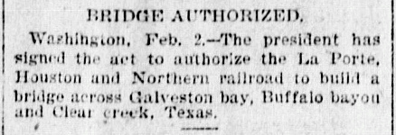
Below Left:
Federal navigation regulations required enactment of a law to approve three GL&H bridges
(Galveston Bay, Cedar Creek and Buffalo Bayou) before work could commence.
(Galveston Daily News February
3, 1896)
Below Right:
Completion of the Buffalo Bayou bridge was reported in the
Galveston Daily News on June 26. The approaches remained in
work. Left:
(Galveston Tribune, July 7, 1896)
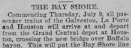
The GL&H began using the Buffalo Bayou bridge for passenger
trains on July 9, 1896.
  |
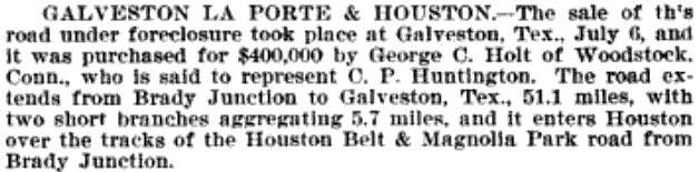
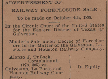
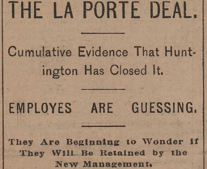
In 1897, SP Chairman C. P. Huntington offered to buy the
GL&H from the Receiver. Railway Review
reported in its March 20, 1897 edition... "An offer has been made, so it is
reported, by Mr. C. P. Huntington for the purchase of the Galveston, La Porte &
Houston... The price offered is said to be $1,000,000.
This is taken to be a confirmation of the promise made by the Southern Pacific
some time ago to make Galveston one of its principal gulf ports. The G. L. P. &
H. is 53 miles in length running from Brady Junction to Galveston."
Huntington's offer was reportedly accepted by a creditor's committee (Railroad
Gazette, June, 1897) but it was rejected by the Receiver.
| Right:
The Receiver's rejection of Huntington's offer was a big mistake. The
GL&H was ultimately sold at a court-ordered sale on July 6, 1898 for
only $400,000. The mysterious George C. Holt of Connecticut was the
buyer, apparently an intermediary, but for whom? Holt asserted he was
only representing himself, but rumors claimed he was working for SP or
Rock Island. Note that Brady is mistakenly referenced in this citation as a GL&H endpoint ("from Brady Junction to
Galveston") even though the
GL&H had already bridged Buffalo Bayou. (The Northwestern Railroader and Railway Age, Vol. 26, Jul - Dec. 1898) |
 |
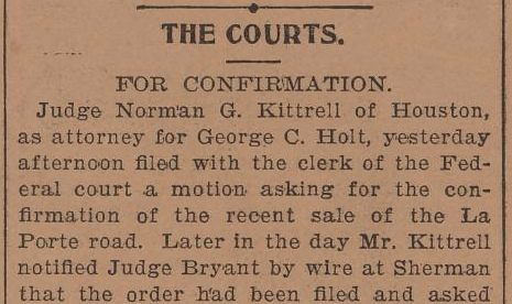
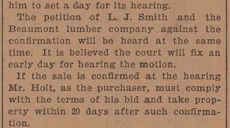
Above Left and Left Center: (Galveston
Tribune, July 20, 1898) Shortly after the sale, Holt filed a motion with the District Court
to confirm the purchase. Two creditors, one of whom was L. J. Smith, the GL&H
contractor, petitioned the court in opposition to the confirmation. Judge Bryant set
the hearing date for August 8, but newspaper accounts of the hearing have not
been located. It is clear, however, that Judge Bryant refused to confirm the bid
results and instead ordered a new sale be conducted. The most likely
explanation is that Holt's bid of $400,000 was
below the court-mandated minimum bid of $500,000. Other bidders might
have outbid Holt but did not do so because they were unwilling to bid the minimum price.
 |
Above Right Center:
A new auction
was set for October 4, 1898, presumably with a new minimum bid. (Galveston
Tribune, September 5, 1898)
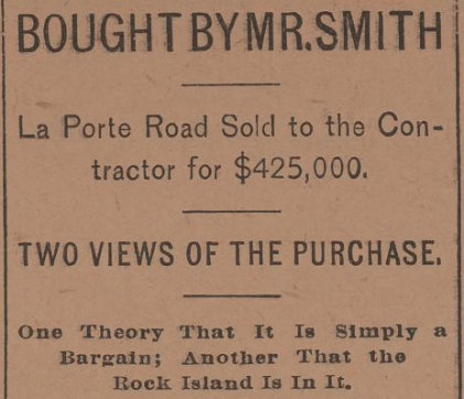
Above
Right: At the sale on October 4, L. J. Smith was awarded
the GL&H with a bid of $425,000. There was speculation that Smith was working
with Rock Island. On October 19, Smith motioned the court to delay his required
final payment "until the controversy concerning priority among the claimants
against the road be determined." Though the purchase funds would go to the
creditors committee, numerous damage claims against the GL&H remained pending
despite the sale. (Galveston
Tribune, October 4, 1898)
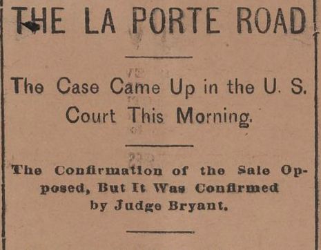
Left: As
expected, Judge Bryant confirmed the sale at a hearing on October 27.
The ruling did not permit Smith to delay his final payment. Like all
bidders, he had made a $50,000 deposit with the court to be credited
toward the purchase, but he could not take control of the railroad until
he paid the balance. (Galveston
Tribune, October 27, 1898) |
It didn't take long for creditors to sue the GL&H for non-payment of
the Receiver Certificates authorized by the Court at the Master's suggestion. After a
ruling in Federal District Court, the case went to the Fifth U.S. Circuit
Court of Appeals in 1900. The published decision of the Fifth Circuit included
a lengthy description of the sad state of the GL&H at the time it began
operations over the HB&MP. The Court explained (Federal Reporter, 1900) that the
GL&H's only connections were...
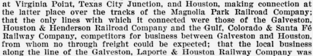
"...bridges
along its line needed repairing..." along with numerous other maintenance
issues. The Court discussed the rationale for borrowing money to build a bridge
across Buffalo Bayou, even though, at the time of receivership, the Galveston
Bay bridge had not yet been completed. The Master's report had insisted that
completing the Galveston Bay bridge was necessary for its...
"...Galveston
with the tracks of the Galveston Wharf Company..." was essential to having
any business at all. Significantly, all four of the railroads "running into
Houston north of Buffalo Bayou" were owned by SP. Later in the ruling, the Court looked back at the justification
for building north across
Buffalo Bayou, quoting from the District Court's decision...
"While the result shows that the road under the receivership was operated at
a heavy loss, even after its extension and completion, yet 95 per cent of the
business done by it was derived from those railroads and manufacturing
industries on the north side of Buffalo Bayou, in Houston, with which there
could have been no connection, and consequently there could have been no
opportunity to get business, unless the extension across Buffalo Bayou had been
made."
 |
Left: Although the
receivership would end for the GL&H when Smith paid the balance of his
bid in November, the advertisement for the GL&H in the Official Railway
Guide issued the same month had already been submitted for publication showing T. W. House as Receiver.
Notwithstanding the
creative license exercised in drawing the map (showing the GL&H operating
exclusively south
of the "Buffalo River") the timetable was presumably accurate. It showed a
stop at La Porte Junction which was a short distance beyond the north
end of the GL&H bridge over Buffalo Bayou. Today, La Porte Junction is known as
Galena Junction which remains an
important location for rail movements along the north side of the Houston Ship
Channel. |
The GL&H's lease of four miles of HB&MP
tracks ended while the HB&MP remained in receivership. Reed says the HB&MP was offered to SP for $10,000 but that SP declined. Instead, the HB&MP was sold by the Receiver to Herbert F. Fuller for $9,100 on
November 1, 1898. Six months later, Fuller transferred the property to the newly
chartered Houston, Oak Lawn & Magnolia Park (HOL&MP) Railway of
which he was a Director. Shortly thereafter, the HOL&MP was sold to I&GN. The
HOL&MP operated passenger service under its name; I&GN handled all freight
service on the line. I&GN had been working with Fuller to acquire the HB&MP, but
liability related to pending lawsuits against the HB&MP likely convinced I&GN to
acquire the property through a subsidiary. I&GN valued the property with the
same vision that had motivated Brady to build it, e.g. ocean-going ships would
someday traverse Buffalo Bayou up to Constitution Bend and industries would
populate the south bank as they did the north bank. I&GN
later built tracks along the south bank all the way to the mouth of Brays Bayou. The city of Houston owned some of this land and established the
Port of Houston, served by I&GN's route through Magnolia Park.
In April, 1899, less than six months after Smith
acquired the GL&H, he sold it to the newly chartered Galveston, Houston &
Northern (GH&N) Railway of which he was a board member. Though an independent railroad, GH&N
management had been selected by SP, which had also assembled the ownership group. In early
1900, the GH&N was sold to SP.
Right: Galveston
Tribune, January 16, 1900
SP decided to merge the GH&N into its GH&SA subsidiary, not
the Houston & Texas Central (H&TC.) This required a modification of the GH&SA's railroad charter
by the Texas Legislature. Thus, the sale to SP did not become
official until the charter revision was enacted in 1905. The GH&N operated under its own
name during those years as a subsidiary of SP, but it was managed and
integrated into GH&SA's operations. By this time, SP had begun operating
its Texas railroads cohesively, but it was not until 1927 that SP took
steps to merge all of them into the T&NO.
|
 |
 |
RCT has a construction record for 1900 stating that the
GH&N built 1.2 miles "between" Brady and Magers. This is
perplexing; the tracks had existed since the opening of the
Buffalo Bayou bridge in 1896, so this appears to be a report of reconstruction
by the GH&N. The RCT reports are organized as "from / to", but this
GH&N report lists "between Brady" as the "from" location.
Presumably, the report meant that
1.2 miles (out of a total of 1.9 miles from Brady
to Magers) was being rebuilt somewhere between the endpoints. This assumes that the construction report was referencing
the same Magers where
Tower 86 was eventually built, which raises the general problem of Magers.
No historical record of any location named Magers has been found
outside of the railroad context (lots of people
seem to have that name, but no towns, communities, neighborhoods, parks, etc.) Thus, how the Magers name originated
as a place, and
precisely what it encompassed and where it was located, is unknown except that Magers was used by RCT to describe the location of Tower 86 when it was
commissioned in 1911.
 |
Prior to acquiring the GH&N, SP had determined that it needed another bridge over
Brays Bayou at Harrisburg. The one built by the GL&H c.1895 went to Tower 102 whereas SP
wanted a bridge to reach the port developing along the south bank of Buffalo
Bayou, due north of Harrisburg. The planned bridge was approved by the Secretary of
War on January 13, 1903 but the bridge was not built. In 1915, SP built a 50
ft. plate girder lift bridge at the mouth of Brays Bayou. This allowed SP to
gain access to various port industries in competition with I&GN without having
to circle around the north side of Magnolia Park.
In 1917, the City of Houston
decided that it needed its own bridge over Brays Bayou to be used for electric
railway mass transit in support of the port's workforce at Harrisburg and La
Porte. The bridge was built
about 750 ft. upstream of SP's lift bridge. Sometime in the 1950s, the lift
bridge was dismantled and SP began using the former electric railway bridge, no
longer in use for transit. The GL&H bridge was just over a half-mile upstream
from the electric railway bridge, and the GH&H bridge was another 275 yards
farther upstream.
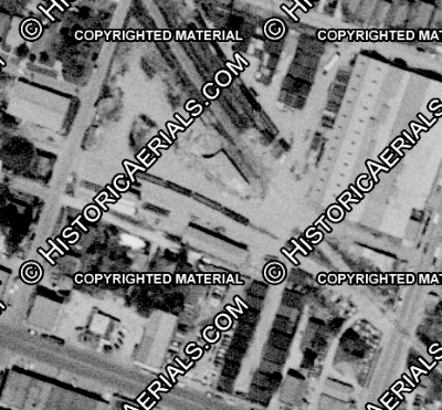
Among the
four railroad bridges over Brays Bayou within the first mile of its confluence
with Buffalo Bayou, the GH&H bridge was the earliest constructed, in the late
1850s. The last to survive are the (rebuilt) GH&H bridge and the electric railway bridge,
both of which remain in service by UP.
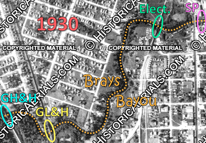
Left: The four known
rail bridges over Brays Bayou near Harrisburg existed simultaneously in
this 1930 aerial image ((c) historicaerials.com.) |
The hurricane of 1900 that obliterated much of Galveston including two of
the three rail bridges onto the island (only Santa Fe's survived) put renewed
emphasis on the value of establishing a ship channel on Buffalo Bayou as a protected deep-water port. Four railroads responded to the
idea by creating the Houston Belt & Terminal (HB&T) Railway in 1905
to coordinate freight movements around Houston and to build a new
Union Station
for passenger traffic. The HB&T's founding railroads contributed various tracks
and the company built additional tracks and a Buffalo Bayou bridge (to Magers) a
mile upstream from the GL&H bridge. By 1924, the growth of industrial trackage motivated the creation of the Port Terminal Railroad Association (PTRA)
to coordinate port-related movements on both sides of the Ship Channel and to guarantee port access to all railroads.
In 1925, Missouri Pacific (MP) acquired three of the four railroads that owned the
HB&T (the fourth being Santa Fe.) MP also gained ownership of the "I-GN" at the same time (the I&GN's
corporate name having changed to International - Great Northern coming out of
receivership in 1922.) The I-GN's former HB&MP tracks
along the south bank of Buffalo Bayou were transferred to HB&T.
With the official opening of the Houston Ship Channel in September, 1914, rail traffic through Magnolia Park
was destined to increase, even though ocean-going vessels did not access the Port
of Houston until 1919 due to World War I. The former GL&H / HB&MP crossing, by
this time a GH&SA / I&GN crossing, was already becoming a bottleneck due to
port-related industrial growth, and the traffic would undoubtedly increase. As a non-interlocked
grade crossing of two railroads, all trains were required to stop before
proceeding across the diamond. The decision was made to interlock the crossing,
and the planning was initiated in the fall of 1914. Tower 102 was authorized for service as
a cabin interlocker on March 31, 1915, reported by
RCT to have an
8-function mechanical interlocker.
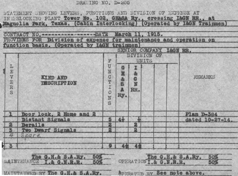 |
Left: Two weeks before RCT
commissioned Tower 102, this interlocker drawing (from SP's archives,
courtesy Carl Codney) was finalized on March 11, 1915. It shows that a
Magnolia Park interlocking plan existed by October 27, 1914.
Although RCT's table of active interlockers dated October 31, 1915
reported Tower 102 as an 8-function interlocker, the drawing shows there
were nine functions, the extra one being the "Door lock" for which the
allocation was split evenly between the two railroads (one-half function
each.) RCT finally corrected the error in its table of active interlockers
published at the end of 1923. Function allocations in the interlocking
plant were important because they were used for computing the share of
recurring expenses each railroad would pay. For Tower 102, both
railroads paid half because they each used half of the nine functions.
The plan states that Tower 102 was a "cabin interlocking" typically used
where a busy line crossed a lightly used line. Signal and derail control
levers would be mounted in a trackside hut and the levers would always be set to signal trains on the busier track
to PROCEED without stopping. When a train on the lightly used track needed to cross,
the train stopped and a crewmember entered the cabin to reverse the controls, signaling trains on the busier
line to STOP. After his train crossed, the crewmember would reset the
controls to permit unimpeded operations on the
busier line. Because the Tower 102 cabin was "Operated by I&GN Trainmen", the
signals were normally lined to allow continuous movement on the GH&SA tracks,
the busier line. This would be reversed in later years
 when
the gate was installed. By then, the HB&T tracks had become the busier
route. when
the gate was installed. By then, the HB&T tracks had become the busier
route.
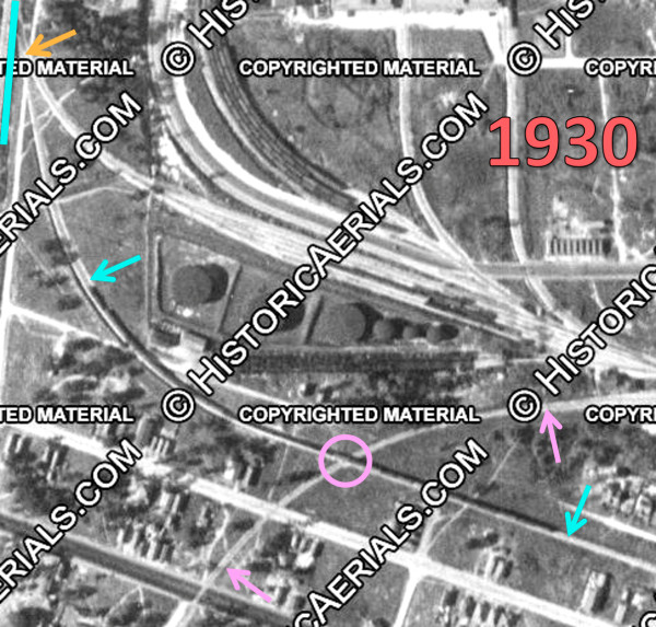
Left: In this 1930 aerial ((c) historicaerials.com)
the Tower 102 cabin casts a shadow to the east in the center of the
image. The cabin was in the east quadrant of the 'X'-pattern crossing. |
Other small but important details are present on the
above document obtained by Carl Codney. It shows the I&GN as the SENIOR
COMPANY. I&GN's seniority was inherited from the HB&MP because its
tracks were laid through the area first. Since the GL&H created the crossing
(and hence, the eventual need for an interlocker) when it built across the HB&MP
tracks, its successor, SP (GH&SA / GH&N) would have been the inferior company
tasked with all of the capital expense of the interlocking...EXCEPT...the
crossing existed as of 1896, prior to the 1901 interlocking law taking effect.
By RCT rules, the capital expense for interlockings at crossings that existed
prior to 1901 would be split evenly among the railroads involved. Another detail
in the document is that the interlocking was MAINTAINED BY the
GH&SA. This is not surprising; as discussed above, the GH&SA was the busier line
through Tower 102. Typically, the railroad with the busier line had the greater
incentive to ensure that there were no maintenance issues with the interlocking,
thus it would take responsibility for maintenance. The recurring maintenance and
utilities costs were split between the railroads according to the function ratio
(here, 50 / 50, as noted above.) Trainmen operated the Tower 102 controls hence
there was no recurring labor cost as there otherwise would be for manned towers.
Since GH&SA had the maintenance responsibility, they almost certainly managed
the cash flow for the interlocking by billing the I&GN on a periodic basis
(monthly or quarterly.)
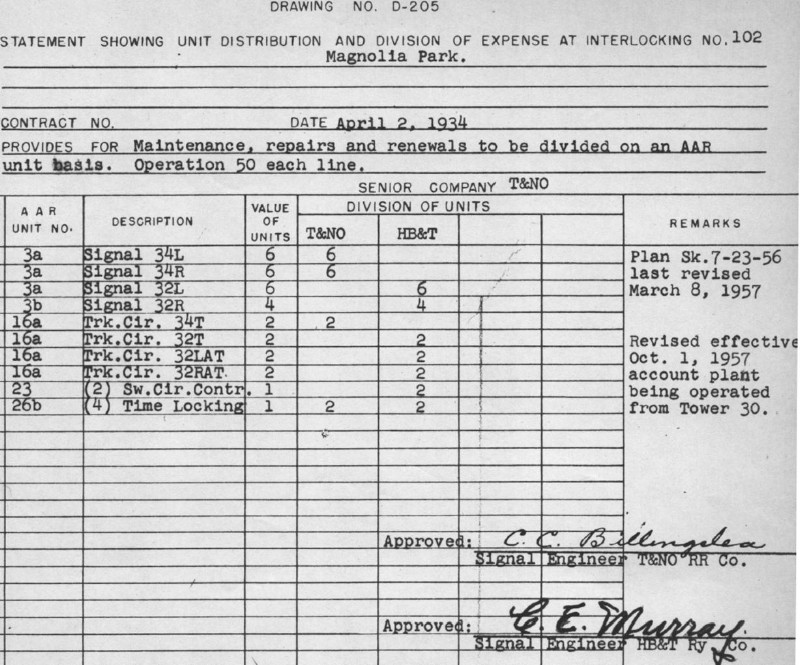
Right: This plan for
Tower 102 (Carl Codney collection) was a redrawn and revised version
beginning April 2, 1934 when the interlocker was converted to an
automatic plant. The GH&SA's participation was replaced by the Texas &
New Orleans (T&NO) Railway, SP's principal operating railroad in Texas
which had leased the GH&SA in 1927 (and then formally merged it in
1934.) The I&GN's participation was replaced by the HB&T, which had
taken over responsibility for what later became known as the Booth Yard
Industrial Lead (leading to a freight yard at the port.) On July 23, 1956,
the interlocker plan was revised with a new sketch ("Sk.") of unknown
changes. The plan was then updated on March 8, 1957 to conform to the
new sketch. On October 1, 1957, the document was
modified to show that Tower 30 had taken over
responsibility for remote control of the Tower 102 interlocking plant.
In the mid 1960s, the automatic interlocker was removed and replaced by
a manual gate (photos at top of page) when the SP line ceased to be a
through route due to the dismantling of the Brays Bayou bridge. The gate was normally closed against the SP
tracks and manually swung across the HB&T
tracks when an SP train needed to cross to serve a business farther
south near Brady. The gate latch provided status
to HB&T approach signals and to the SP dispatcher responsible for train
movements in the area. A latched gate would result in a
PROCEED signal; an unlatched gate produced a warning signal on the HB&T
telling trains to plan to STOP at
the diamond.
Left: This 1947 image
((c) historicaerials.com) shows the cabin has been replaced by equipment
cabinet(s) for the automatic interlocking plant. The bright ROW to the
right is an I-GN spur used to reach (as of
1948) the Southwest Fabricating and Welding Co. located farther south
near Brady. |
 |
In its order
of November 8, 1901, RCT required all
crossings to be protected by gates pending further orders for interlocking plants.
This wasn't universally implemented, but eventually, most of the significant
non-interlocked crossings had gates.
But ... even with gates installed, state law required all trains to
stop at all crossings. This requirement remained in effect until the Interstate
Commerce Commission (ICC) began regulating interstate rail lines in 1920 (which
included essentially all rail lines in Texas.) The ICC allowed trains to
approach gates at "restricted speed", i.e. slow enough that a full stop could be
achieved if a gate was found to be closed against the approaching train.
Otherwise, trains could proceed past the open gate without stopping. Tower 102's
gate was rare (in Texas) because it was connected to
signals to provide status to approaching trains (and to the dispatcher
controlling the area.) Trains could maintain a higher track speed when passing a PROCEED signal
since they were assured of finding the gate open when it came into view.
 |
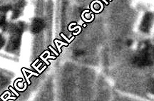
Left:
This snippet from a 1957 USGS topo map shows the I-GN spur coming off
the main track northeast of the Tower 102 crossing and proceeding
southeast parallel to the T&NO (GH&SA / GH&N / GL&H) tracks, terminating at or
near Brady. Note that the former HB&MP spur between Brady and HB&MP
Junction is shown mostly intact from each end, with a break in the
middle.
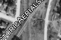
Right:
The center of this 1957 image ((c) historicaerials.com) shows railcars
on the spur immediately west of the connection at Brady. Mapping the
spur's street grade crossing to the west to
current imagery
shows the spur roughly equidistant between Ave. B and Ave. C. As noted
earlier, the spur ROW projects eastward onto Ave. B aligned 70 ft. farther north compared to west of Brady,
suggesting Ave. B
east of Brady was built after the spur extension to the port was abandoned, prior to 1930. The GL&H bridge over
Brays Bayou
was dismantled in the mid-1960s and the tracks from the bridge to Brady were
removed. The spur was probably removed at this time. At HB&MP Jct., there is clear
evidence of the spur only in 1957 imagery, but no railcars are present. |
 |
 |
Left: This
1930 aerial image ((c) historicaerials.com) shows the area southeast of
SP's (GL&H) Buffalo Bayou bridge. Tower 208 was established in this
vicinity in 1957.
As of 1930, what eventually became Tower
208 (pink circle) was a crossing of the HB&T (pink arrows) and SP (blue
arrows - note the train on the tracks between the arrows) although SP
might already have transferred the track to PTRA. The HB&T track was the
original HB&MP acquired by the I&GN through the HOL&MP in 1899. The
tracks were transferred to HB&T after the I-GN was acquired by
MP in 1925. The association of SP's track with the PTRA comes from the
content of a letter from HB&T to RCT dated November 12, 1957 wherein
HB&T announced that an interlocker at Crossing C (near Old City
Yard and Booth Siding, which eventually became Booth Yard) had become
operational on September 24. The letter states that this junction was "not previously interlocked but now controlled by Tower
30". HB&T requested RCT to "please assign tower number to interlocked
HB&T (I-GN) - PTRA crossing". The next day, a response letter from RCT
stated that the engineering department "can't find a file for this interlocker,
but will set one up", requesting additional details as to the precise nature of
the interlocking. This was provided in a return letter on November 15. On
November 18, the Tower 208 designation for Crossing C was officially
conveyed to HB&T in a letter from RCT.
The SP / PTRA tracks switched
off of the SP line to Tower 102 (blue line) immediately south of the
Buffalo Bayou bridge (located off the image directly above the blue
line.) The tracks immediately switched again (orange arrow) into two
lines: one that went to the large yard visible in the image, presumably
a PTRA facility, and another that made a larger curve through Tower
208 and continued southeast along the Ship Channel. The 1930 imagery
shows this SP / PTRA line feeding into a large yard farther east at the
Port of Houston. It probably connected by some means with the lift
bridge at the mouth of Brays Bayou that SP had opened in 1915, but the
imagery has insufficient clarity to follow the tracks that far. Between
1962 and 1964, SP made the line a double-track that began just east of Tower
208 and reverted to single-track about 250 yards north of SP's bridge over Brays Bayou
(the former electric railway bridge.) This became the main line from
Englewood Yard to Galveston, allowing the
original (GL&H) Brays Bayou bridge to be dismantled c.1965,
triggering the downgrade of Tower 102 to a manual gate with signaling
since it was no longer a through-route for SP. |
Above:
This image is taken from a map that appeared in the May, 1928 edition of
Port Book, a
periodical produced by the Port of Houston. The map is oriented with North to
the left showing the vicinity of the Turning Basin. At the time, the Public Belt
(PB) was the railroad operated by PTRA. The blue circle denotes the
future Tower 208; whether it was known as Crossing C in 1928 is undetermined. A significant detail is the map's
illustration of two bridges (red oval) over Buffalo Bayou near the Turning
Basin. One was SP's GL&H bridge; the other was a parallel PB bridge. This map
is the only evidence
of the PB bridge that has surfaced thus far, and
neither the bridge nor rights-of-way approaching its planned location appear on 1930 aerial
imagery, only two years after the publication. It seems likely that the
bridge had been
planned and was incorporated into the map on that basis, but the 1930 imagery suggests it was
never built. The tracks shown here on the
south side of the PB bridge were actually connected to the south approach to SP's bridge,
at least by 1930. PTRA and SP shared the GL&H bridge over Buffalo Bayou, so
perhaps difficulty with the sharing arrangement had motivated PTRA to begin
planning its own bridge.
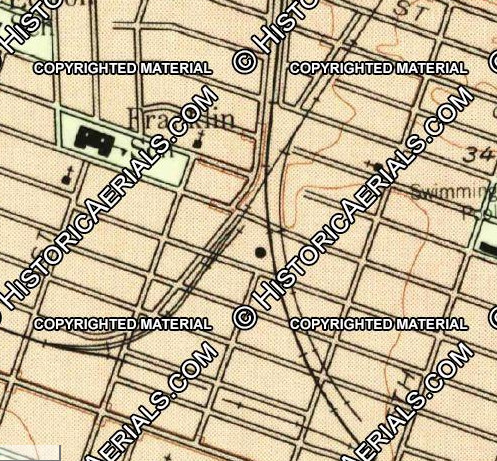
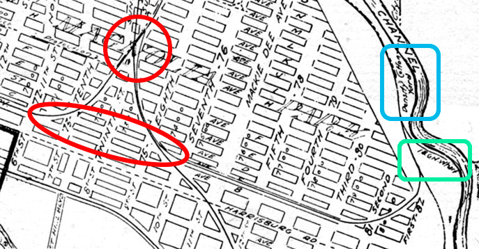
Right: annotated, wide area view of Magnolia
Park from a 1920 map of Houston
This map has been annotated
to show a bigger picture of the rail lines in Magnolia Park. Numbered
interlocking towers are shown in red, though Towers 208 and 214 would
not exist until the 1957 - 1964 timeframe. No rail lines are shown
assigned to PTRA since it did not exist in 1920. The map also does not
show the electric railway bridge over Brays Bayou. Having been initiated
in 1917, it should have been completed by 1920, but the map might have
intentionally omitted electric rail lines and trolley lines.
North
of Buffalo Bayou, SP had a mix of GH&SA and T&NO tracks, but by this
time, the GH&SA tracks were limited to areas east of Tower 5.
South of Buffalo Bayou, the map does not show the tracks that departed
SP's line immediately south of the bridge to curve along the port,
presumably all the way to the Brays Bayou lift bridge. These tracks
appear on 1930 imagery, and probably existed by 1928 (see map above.) It
seems likely that they existed in 1920. SP's lift bridge at the mouth of Brays Bayou had opened in 1915
and SP's GL&H bridge over Buffalo Bayou had opened nearly twenty years
earlier. Whether SP had built tracks along the port between the two
bridges by 1920 is undetermined, but this map suggests it had not.
As illustrated
below, the
map does not show the original HB&MP spur intact between the former
HB&MP Jct. (west end of red oval) and Brady (east end of red oval.) This
could be a simple oversight by the cartographer or it may indicate that
the spur had been dismantled between those points as of 1920. Since
short spurs from both ends are visible in 1957 imagery, those tracks
were either reinstalled later or else they were intact in 1920. Aerial imagery
prior to 1957 shows the spur's ROW extending west from Brady for varying
distances (depending on image quality for specific years) but never
shows an obvious ROW east from HB&MP Jct. until 1957 when tracks are
visible.
Note that the spur east of Brady
continues to the port, intersecting I&GN tracks near the I&GN Wharf
(green rectangle) and the Density Cotton Yard (blue rectangle.)
The map also shows that the I&GN spur to the immediate east of Tower 102
(red circle) was intact and appears to connect to the spur at Brady,
forming a complete circle for I&GN tracks in Magnolia Park.
 |
 |
The GL&H bridge over Brays Bayou was dismantled
by SP between 1964 and 1966 per historic aerial imagery. Tracks north to
Brady were removed, but tracks south from Buffalo Bayou to Brady
remained intact for
industrial access.
Right:
A 1982 HB&T Employee Timetable noted the Booth Yard Industrial Lead had a "crossing gate
with SP" (Tower 102) and a "manual interlocking with PTRA"
(Tower 208) both of which were "controlled by SP Dispatcher."
The location and function of the "PTRA automatic interlocking" is
undetermined. |
 |
 |
 |
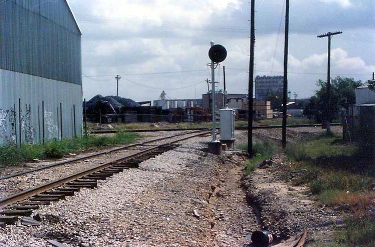
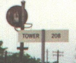
Two views looking north at the Tower 208 diamond:
Far Left: Kenneth Anthony
photo, undated;
Left: Google Street View, Dec. 2019 with radio sign
Below:
Westward view of Tower 208 sign
c.1998. (Jim King photo)
 |
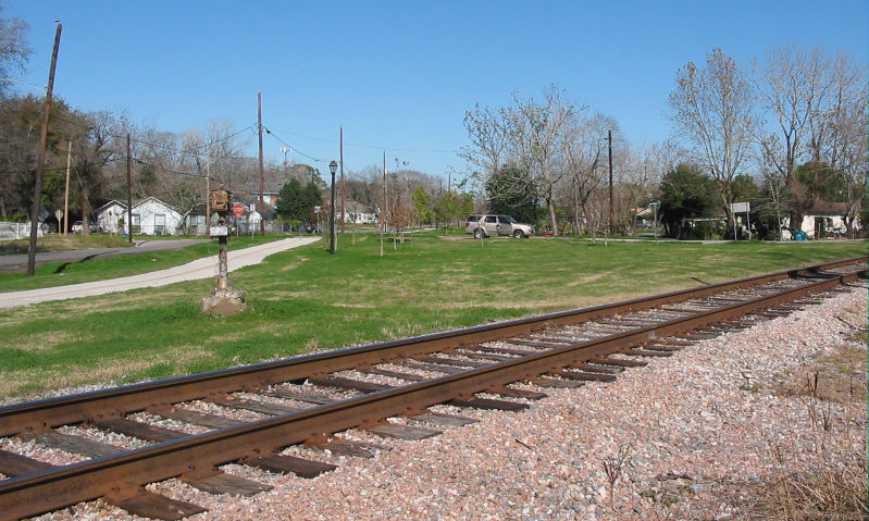
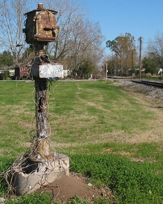
Above: Facing north c.2006, the Tower 102 crossing
is at the south end of a
greenbelt park and trail (the
Sunset Trail) built along the former SP ROW. The HB&T Magnolia Branch
continues to Tower 208 to the right. The diamond was in the foreground and the
SP tracks ran directly ahead passing to the right of the gatepost. The pivot
post for the gate was to the right of the SP tracks in the acute angle between
the two rail lines. The control box (still padlocked!) atop the gatepost
provided a manual override for signals.
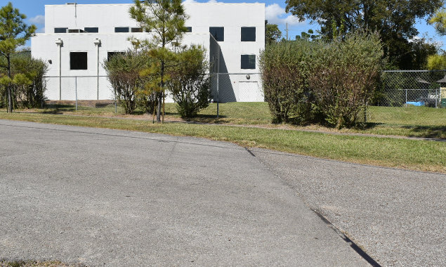
(Jim King photos) Below Left:
The Community Family Center on Ave. E was built atop the former SP right-of-way.
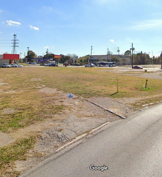
(Abel Garcia photo) Below Right: Rails are
still evident in this December, 2019 Google Street View looking south from 75th
St. where the SP tracks crossed approximately 220 ft. south of the
intersection of 75th St. and Avenue C, i.e. this is the location the railroads
called Brady. Mapping the spur switch using coordinates taken from 1957 aerial
imagery places it on the opposite (west) side of 75th St., only a handful of
yards beyond the curb. The large utility tower above the red sign sits on the SP
ROW and its power lines proceed southeast to cross Brays
Bayou at the former GL&H bridge site.
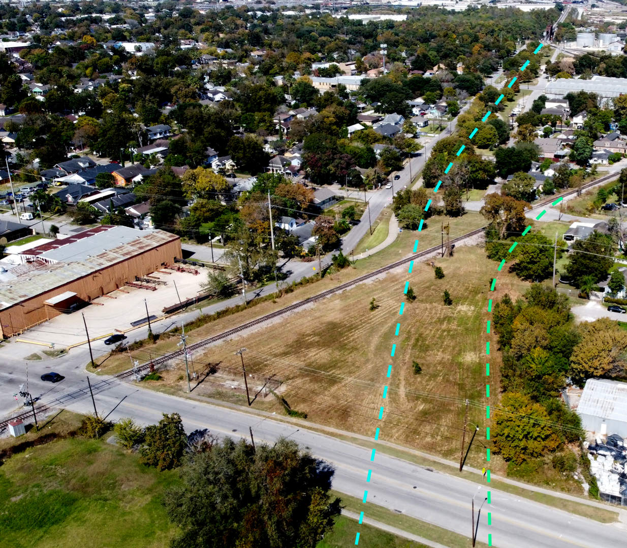
Below: This drone image of the Tower 102 crossing was
captured in Nov. 2020 by Abel Garcia. The HB&T Booth Yard Industrial Lead remains
active through the former crossing. The annotations show the SP ROW (blue dashed
line) and the spur track ROW (green dashed line.) The Buffalo Bayou bridge is located where the dashed blue
line ends near the top right corner of the image. A track to the east from the
south end of the bridge splits into two tracks to serve the industries along the
ship channel. The one closest to the camera continues southeast and crosses the HB&T at Tower 208.