Texas Railroad History - Tower 95 - Brenham
A Crossing of the Houston & Texas Central Railway and the
Gulf, Colorado & Santa Fe Railway

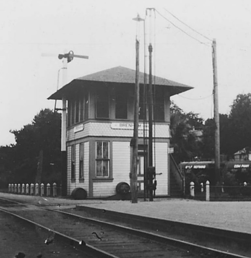
Above: This photo of Tower 95
was taken by George W. La Lumiere, a photographer based in Houston hired by
Southern Pacific. Based on city directories and census records, La Lumiere
appears to have been active in the 1915 - 1920 timeframe. Although
some of his photos have dates noted on the back,
this one does not. (Ken Stavinoha collection)
 |
Left:
The signs on the side of Tower 95 appear to say 'Brenham' without the tower
number. The assumption is that these photos were taken before the use of white,
rectangular placards with black numerals became the standard. Whether this
standard was actually mandated by regulation has not been determined, but it was
certainly followed. Because of the dearth of tower photos prior to the 1930s, it
is difficult to estimate when this standard was first used, but it is seen on
virtually every tower photo taken in the 1930s or later. The horizontal,
rounded-end style of the sign in this photo appears to be the standard that
Southern Pacific used (e.g. Tower 41) before it
began using the rectangular white placard. (Russell Crump archives, Temple
Railroad and Heritage Museum) |
The town of Brenham dates to the days of the Republic
of Texas in 1843 when the settlement changed its name from Hickory Grove. Within
a year, Brenham had become the county seat of Washington County. In 1856, local
businessmen chartered the Washington County Rail Road Co. to build a railroad to
Hempstead, which was expected to become a stop on the Houston & Texas Central
(H&TC) Railway coming north out of Houston. The H&TC reached Hempstead in 1858
and continued construction north toward Navasota. That same year, the Washington
County Rail Road started at Hempstead and built west toward Brenham. With a
delay in bridging the Brazos River, it was not until 1861 that Brenham saw its
first train. After the Civil War, the Washington County Rail Road was acquired
by the H&TC. H&TC
extended the line west to Austin using tracks of 5 1/2 ft. gauge, driving the last spike there on Christmas Day,
1871. The spikes were driven a second time when H&TC converted the line to standard gauge in 1877.
The H&TC was acquired by Southern Pacific (SP)
in 1883, and eventually leased (1927) and merged (1934) into SP's operating
railroad for Texas and Louisiana, the Texas & New Orleans (T&NO) Railroad.
The second railroad into Brenham was the Gulf, Colorado & Santa Fe (GC&SF)
Railway. It was founded because of Galveston civic leaders' desire to have
a railroad to Galveston Island that did not pass through Houston; they accused Houston authorities of periodically interfering with Galveston trains to create
business for Houston shippers. With a new bridge over Galveston Bay, Santa Fe
built out of Galveston well south of Houston and reached
Arcola in 1877. Richmond was next, in 1879, but
since Richmond was already a stop on the Galveston, Harrisburg & San Antonio
(GH&SA) railroad, city leaders decided to ignore Santa Fe's request for a
right-of-way into downtown. With no other choice, Santa Fe's route came up the
west side of Richmond to reach the GH&SA tracks a mile west of downtown.
From there, the GC&SF paralleled the GH&SA tracks for another two miles west
where an interchange point between the two railroads,
Rosenberg Junction, was established in late 1879. Santa Fe
crossed over the GH&SA and continued northwest to Sealy
in January and Brenham
in April, 1880. Work continued at an accelerated pace, and by the end of 1881,
they had completed another hundred miles to Belton plus 128 miles from
Temple (which was originally a construction camp
near Belton) to Ft. Worth. GC&SF's line through Brenham
to Temple and Ft. Worth was
their original main track, and it remains an important route for Santa Fe's
successor, Burlington Northern Santa Fe (BNSF).
In July,
1901, a new state law mandated interlockers for busy railroad crossings, and in
May, 1902, the Railroad Commission of Texas (RCT) issued regulations governing
the interlocker approval process. Without an interlocker, trains could not cross
another railroad at grade without coming to a complete stop, adding delay and
wasting the energy stored in a train's momentum. The state also mandated the use
of manual gates as an interim safety measure until a crossing could be
interlocked. For new crossings, the railroad initiating the crossing was
responsible for funding the interlocker and any associated tower or cabin
facilities. For existing crossings, these capital expenses would be shared by
the participating railroads. Operation and maintenance (O&M) expenses were also
to be shared, generally on a weighted function basis. Brenham was not on RCT's
initial priority list of crossings to be interlocked, but that did not excuse
the railroads from
taking action to initiate an interlocker installation. Yet, SP and Santa Fe waited more than a decade
before finally installing a 21-function electric interlocker at the Brenham
crossing, commissioned as Tower 95 by RCT on June 29, 1914.
SP used an
internal
form "D-205" to record interlocker functions and O&M expense allocations for
each interlocker with which it was involved. The original D-205 drawing for
Tower 95 was dated July
29, 1913, exactly eleven months prior to the date the tower was commissioned.
Typically, a tower number was assigned by RCT when they created a file for
correspondence associated with a planned interlocker installation, usually as a
result of a notification letter from the railroad responsible for implementing
the interlocker. In most cases, the chronological order of tower commissioning
dates did not deviate substantially from their numerical order, but there were
exceptions such as Tower 95. The original D-205 drawing reflects a design plan
dated February 26, 1913, suggesting that the planning effort for the tower began
more than a year before its commissioning. But considering other evidence, there
was apparently a large delay just to create the initial design. The next tower
that was numbered
higher than Tower 95
and also commissioned
after Tower 95 was Tower
101 on December 1, 1914. Towers 96 through 100 all received RCT approval
before Tower 95 did despite higher tower number assignments by RCT due to later
notifications. In particular, the intent
to interlock the Island crossing on the Galveston Causeway (assigned as
Tower 96) must have been passed to RCT by early
1912 since it was able to be commissioned by September -- a nine month process
would be reasonably expeditious. Thus, SP had notified RCT of the intent
to interlock the Brenham crossing at least by early 1912 (and more likely in
1911) which resulted in Brenham's tower number preceding that of the Island
interlocker.
For unknown reasons, it took at least 30 months to design, build, install and
commission Tower 95.
Below Left: As changes occurred at interlocked
crossings, SP's method was to mark revisions on the original D-205 and then
eventually re-write the entire document. The REMARKS column indicates that this form
D-205 was last updated on December 23, 1926 to reflect a function count
change that had occurred in July, 1925. Previous updates were noted in March and
June, 1924. The document was subsequently marked as "Superseded effective June
13, 1927". (Carl Codney collection)
Below Right: The June 13, 1927
rewrite of the D-205 for Brenham shows that although the tower was maintained and operated by H&TC, Santa
Fe paid nearly 82% of the O&M expenses. This was a 6% increase from the
original share. (Carl Codney collection)


According to noted SP historian David Bernstein, Tower 95 closed on September 5, 1931.
The
interlocker was retained and its controls were relocated to the Union Passenger Station across the
street. Presumably razed, the fate of the tower structure has not been
determined. In February, 1957, an automatic interlocker design plan was issued
for Tower 95, becoming effective on August 22nd of that year. Each railroad had
eight signals and two track circuits resulting in a 50/50 split on O&M costs.
SP retained staffing and maintenance responsibility.
By
1961, one hundred years after the first train entered Brenham, SP knew that their
track segment east of Tower 95 to Hempstead was in physical jeopardy. The Brazos River bridge would not survive the next
major flood or
hurricane, and building a new bridge was not enough. It was adjacent to a
90-degree turn in the river which caused the last mile of right-of-way east of
the bridge to be perilously close to the river bank. Significant erosion with
each new flood meant that the grade would be undercut sooner rather than later;
at minimum, two miles of track would need to be relocated. Knowing that traffic
revenue could not justify the expense of rerouting the line and building a new bridge, SP petitioned the Interstate Commerce Commission (ICC) for
permission to abandon the Hempstead to Brenham segment, with both towns retaining
SP service. Under Finance Docket 21573, the ICC
accepted SP's petition on August 17, 1961.
On September 11, 1961, Hurricane
Carla hit Texas and SP's Brazos River bridge was heavily damaged. The bridge had
probably been in service up to that date as this was only a little over three
weeks since the ICC proceeding. With abandonment greatly accelerated by the
hurricane, SP reported to RCT that by the end of 1961, it had officially abandoned 10.4 miles of track between
Hempstead and Chappell Hill.
The remaining 8.1 miles into Brenham was abandoned in 1962. Brenham was
still served by SP trains from the west, and Hempstead was still served by SP's
route between Houston and Navasota, which remains in use today by successor
Union Pacific. In 1979, SP abandoned their line between Giddings and Brenham, 35
miles, with tracks in Brenham sold to Santa Fe
to serve local industries.


Above Left: The 1931 Sanborn Fire Insurance Co. map of Brenham shows the
T&NO/GC&SF
crossing in downtown Brenham, with Tower 95 sitting across the Santa Fe tracks
from the
Union Passenger Station. Above Right: Magnification reveals a 2-story tower with the stairs located on the
north side.


Above Left: This historic post card
shows Brenham's Union Station, date unknown. The station was across the Santa Fe
tracks from Tower 95. SP's track
is in the foreground passing along the south side of the station. Tower 95 is
off the image to the left, adjacent to the crossing diamond. The rooftop sign says "BRENHAM" in the
middle, with "GC&SFRR" to the left and H&TCRR" to the right, each
sign angled to face their
respective tracks. The station is no longer standing, and the date of its demise
remains to be determined. Above Right:
West of downtown, the former SP tracks are intact for a couple of blocks, and
then out of service. But the rails are still present all the way to Blinn Blvd.
where they end in the pavement behind the camera. This view is to the east from
Blinn Blvd. (Google Street View, 2019) Below Left: The
Santa Fe freight depot still stands in Brenham (repurposed as an office
building) at the
intersection of Peabody and South Austin St., less than fifty yards north of
where Union Station sat. (Google Street View, 2008)
Below Right: The former SP line is still in use by BNSF for 1.7 miles east of the diamond.
Here, looking east beyond S. Blue Bell Rd.,
the tracks begin to curve south and end in a half mile. The Blue Bell Creamery
appears to be the last industry served. (Google Street View, 2019)


Above: This Google Earth
image is annotated
with heritage railroads and shows Tower 95's location, but all lines are currently owned by BNSF.
Below: In 2019, Tom Kline took
these drone photos of BNSF locomotives southbound (left) and northbound (right)
across the Tower 95 diamond. The brown building with the manicured lawn occupies
the site of Union Station. The building houses Washington County's Chamber of
Commerce Information Center, Convention and Visitor's Bureau, and Economic
Development Foundation.


Above: Looking west down the
former SP line from the Hwy 36 grade crossing in downtown, a block light remains
in use protecting the former Tower 95 diamond. In case anyone forgets which two
railroads crossed here, the "Santa Fe & S.P. Cafe" provides a sign
as a reminder. Below: This view is
south from the Peabody Street grade crossing down the Santa Fe main line with
the former SP tracks crossing horizontally in the image. The "Brenham
Interlocker" sign identifies the cabin where the electronics reside. Although
there are many examples of modern interlocker cabins retaining a reference to
the original tower number, there's no evidence of that here. (Google Street View
images)


Above: One concrete bridge
support remains intact at the site of the former SP bridge over the Brazos
River.
Below: SP's grade was so close
to the Brazos River east of the bridge that a new bridge and a line relocation
project would have been required to maintain service between Hempstead and
Brenham. (Google Earth images, 2019)
