
Above: undated photo facing east along the Santa Fe tracks at Tower 52; Southern Pacific tracks cross at an angle on the opposite side of the tower (A. E. Brown, Collection of Gordon C. Basett)
A Crossing of the Gulf, Colorado & Santa Fe Railway and the San Antonio & Aransas Pass Railway
Above: undated photo facing east along the Santa Fe tracks at
Tower 52; Southern Pacific tracks cross at an angle on the opposite side of the
tower (A. E. Brown, Collection of Gordon C. Basett)
A Commission charged with finding a suitable location
for the seat of Milam County in 1846 chose a site near the center of the
county and named it for a Scotsman, Ewen Cameron, who had served two tours in
the Texas Army. In 1873, the International & Great Northern (I&GN) Railroad
built across the southern part of Milam County, acquiring land and establishing
the new town of Rockdale about a dozen miles due
south of Cameron. Rockdale was an immediate competitor to become the principal city of Milam
County, and the railroad gave it an edge. Had it been more
centrally located in the county, it would have quickly prevailed in a vote to
relocate the county seat out of Cameron. Although Rockdale came up short in county seat elections held in 1874
and 1880, continued growth fueled by the I&GN would have given Rockdale sufficient population to win the next election. Cameron's
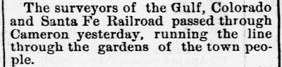
citizens were only able to prevent that from happening by attracting a railroad to build
through their town.
That railroad was the Gulf, Colorado & Santa Fe (GC&SF)
Railway. It had been founded in Galveston in the early 1870s; local politicians
were seeking a railroad onto Galveston Island that did not pass through
Houston. Santa Fe built a bridge over Galveston Bay and laid tracks to the west,
well south of Houston, reaching
Arcola in 1877.
Construction proceeded to Richmond in 1879. As Richmond was already a stop on
the Galveston, Harrisburg & San Antonio (GH&SA) railroad, city leaders chose to ignore
Santa Fe's request for a separate right-of-way through town. With no other
choice, Santa Fe paralleled the existing GH&SA tracks through Richmond but
stopped beyond the west city limits to found the new town of
Rosenberg. Santa Fe
resumed construction, crossing over the GH&SA and continuing northwest to
Brenham in April, 1880. Work continued at an accelerated pace, and by the end of
1881, Santa Fe had laid another hundred miles of track to Belton, passing
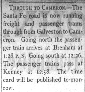
through Cameron 62 rail miles northwest of Brenham. Also in 1881, Santa Fe built
128 miles to Ft. Worth from Temple, which at the
time was merely a construction
camp east of Belton.
 Galveston Daily News, April 22, 1877 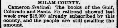 Galveston Daily News, May 14, 1878 |
Left: Santa Fe's plans to build through Cameron
and Milam County were established long before they had even reached
Richmond. Passing well south of Houston on a mostly westward trajectory
out of Galveston, the plan was to angle northwest through Brenham,
Caldwell, Cameron, Belton and Comanche heading toward Colorado (it was,
after all, the Gulf, Colorado and Santa
Fe.) In 1879, the railroad went through a foreclosure and was purchased
by its Treasurer, George Sealy, who reorganized the company under its
original charter. Construction resumed at multiple locations along the
planned route with an emphasis on establishing service into Belton. A
major construction camp was established at Temple, named for Santa Fe's
chief engineer, Bernard Temple, which became the branch point for a line
northward to Ft. Worth. The Ft. Worth branch morphed into the main line
as the westward expansion beyond Belton slowed. Right: Service to Cameron from Galveston began in November, 1880. (Brenham Daily Banner, November 9, 1880.) |
 |
The main reason the line to Ft. Worth became the GC&SF's main line was because of discussions with the vastly larger Atchison,
Topeka & Santa Fe (AT&SF) Railway. AT&SF was willing to acquire the GC&SF on
favorable terms if three GC&SF construction projects were completed within a
year. The deal signed in 1886 required completion of a main line extension
north from Ft. Worth to Purcell, Oklahoma,
construction of a Dallas -
Paris line, and construction of a branch line from Cleburne to
Weatherford. The acquisition proceeded as planned in 1887 and the GC&SF began
operating as a wholly-owned subsidiary of the AT&SF. The GC&SF operated under
its own name until August 1, 1965 when it became fully merged into the AT&SF. In
1995, the AT&SF merged with Burlington Northern to create Burlington Northern
Santa Fe (BNSF.)
The Santa Fe tracks through Cameron were in place long before
the next railroad into town had even been chartered. The San Antonio &
Aransas Pass (SA&AP) Railway began in 1884 with plans to connect
San Antonio
with the Gulf port of Aransas Pass. Efforts to establish a deep water port on
Aransas Bay dated back to the late 1850s, but it was not until Congress got
involved in 1879 that the idea was translated into action. By late
1886, tracks had been laid between San Antonio and
Corpus Christi, chosen as the preferred endpoint instead of Aransas Pass.
The SA&AP continued by adding other branch lines in south Texas, and in 1887,
work began on a lengthy branch line to Waco. Construction proceeded from Yoakum
north to West Point that year, and in 1888, the
SA&AP began planning to build south from Waco. Segments from Waco to Lott and
West Point to Lexington were completed in 1889, and the final 58 mile segment
between Lexington and Lott was completed in 1891. The last gap, between Cameron
and Lott, had been held up by a lawsuit filed by a contractor for claims of
unpaid grading work. After the suit was resolved and the line completed, the
Brenham Weekly Banner of October 29, 1891 simply reported "The gap
between Cameron and Waco has been closed." With railroad service in four directions,
Cameron prospered, reaching 2,000 population in 1892.
While the tracks to
Waco were under construction, the SA&AP went into receivership on July, 14 1890. The
railroad's General Manager, B. F. Yoakum, was named Receiver, though he was only
30 years old at the time. His boss, Uriah Lott, President of the SA&AP, had
recognized Yoakum's brilliance early on and had promoted him rapidly from
Traffic Manager to General Manager in a few short years. (Lott was so impressed,
he named the
new town of Yoakum, Texas for him -- as a railroad CEO years later, Yoakum would
return the favor by hiring Lott as President of the St. Louis, Brownsville &
Mexico Railway, "SLB&M".) As Receiver, Yoakum was able to get the bankruptcy court
to approve completion of the line to Waco while he worked on a plan to reorganize
the SA&AP out of bankruptcy. Yoakum knew that soon after the SA&AP
was discharged from bankruptcy in 1892, it would be acquired by Southern Pacific
(SP), hence Yoakum arranged to take an executive position with the
GC&SF when his Receiver duties were complete. In 1903, SP got quite a
shock when they were suddenly sued by the Railroad Commission of Texas (RCT)
which claimed that their acquisition of the SA&AP
eleven years earlier was unlawful (supposedly violating Texas law that
prohibited railroads from buying direct competitors.)
SP
claimed (but was unable to prove) that the lawsuit was attributable to B. F. Yoakum through his
close relationships with RCT commissioners. At the time of RCT's
lawsuit, Yoakum was the
Chairman of the St. Louis San Francisco Railway and he was working to establish
a consortium of rail lines along the Gulf Coast to
compete with SP. The lawsuit put SA&AP's construction bonds in limbo, causing
them to stop their efforts to build a rail line to the Rio Grande Valley.
Coincidentally (or...not), Yoakum's SLB&M was under
construction between Brownsville and Houston via Algoa.
In 1904, SP lost
the lawsuit and the SA&AP returned to independent ownership. Yoakum
completed his line to the Valley while the SA&AP suspended their
efforts to build to the Valley.
In
the Transportation Act of 1920, Congress directed the Interstate Commerce
Commission (ICC) to promote and plan consolidation of U.S. railroads into a
limited number of "systems". The ICC responded by hiring economist William Z.
Ripley to develop a plan. The Ripley Plan proposed that SP
would be in
charge of one of these systems, and that the SA&AP would become part of it. On
December 6, 1924, SP filed an application with the ICC for authorization to
purchase control of the SA&AP. The State of Texas opposed the move, but lost
their challenge before the ICC, which granted SP's application. In March, 1925,
SP re-acquired the SA&AP
under the authority granted by the ICC and leased it to another SP railroad
active in south Texas, the Galveston, Harrisburg & San Antonio (GH&SA) Railway. (Shortly
thereafter, the SA&AP's stalled construction to the Valley was resumed after
a twenty year hiatus.) In 1927, SP leased the GH&SA to the Texas & New Orleans
(T&NO) Railroad which was becoming SP's operating railroad for its Texas and Louisiana lines.
The SA&AP and the GH&SA were merged into the T&NO in 1934.
The T&NO consolidated the SA&AP tracks into its network and for the next twenty-five years,
T&NO operations continued along the former SA&AP line between south Texas
and Waco via Cameron.
In 1959, SP abandoned fifty miles of the former SA&AP tracks from Cameron
south to Giddings, a major junction about forty miles north of
Flatonia. SP still had two other lines into Waco, so Cameron was served
by local T&NO trains running south out of Waco and back. In 1967, SP abandoned another 37 miles of
the former SA&AP line from Waco south to Rosebud. This isolated the track segment
between Cameron and Rosebud from SP's network. To reach Cameron, SP
made arrangements to use Santa Fe's tracks from their nearest mutual connection
at Caldwell. SP then operated a switcher from Caldwell to reach
Cameron and Rosebud on an as-needed basis. In 1977, the tracks
were abandoned from Rosebud south to Quinif, a location on the northern outskirts of Cameron
which SP continued to serve with the Caldwell switcher. Seven
years later, SP sold the Cameron - Quinif track segment to Santa Fe and
it remains in service today by BNSF.
Below: A new rail-served facility was added at Quinif
between February, 2017 (left)
and January, 2018 (right).
Google Earth imagery

In 1901, RCT began exercising new authority to regulate both grade and grade-separated crossings of railroads in Texas for safety purposes. Tower 52 was commissioned by RCT on July 21, 1904 to manage an electric interlocker for the Cameron crossing. The interlocker had 21 functions dispersed over 17 operating levers in the tower. By the end of 1930, the function count had more than doubled to 43, indicative of the sidings, industry spurs, exchange tracks and signals that had been added near the tower over a period of more than twenty-five years.


Above Left: This map shows the railroads in the vicinity
of Cameron, with tower numbers identified in the purple circles.
Tower 24 controlled the Santa Fe crossing of the
Missouri-Kansas-Texas (MKT) line through Temple. Tower
23 controlled the Santa Fe crossing of the I&GN. Both of these towers were
built and staffed by Santa Fe, as was Tower 52. Tower
54 in Rockdale was built and staffed by the I&GN.
Above Right: The Tower 52 crossing was on the southwest
side of Cameron, just far enough away from the center of town that the crossing
does not appear on any Sanborn Fire Insurance maps of Cameron. BNSF now operates
the remnant of the original SA&AP tracks from the Tower 52 junction north to
Quinif.
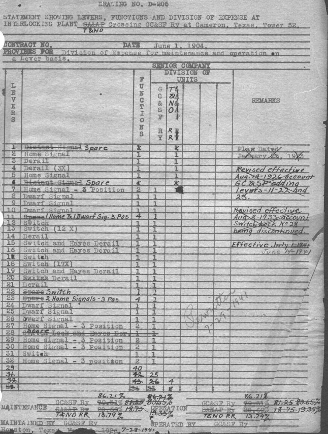 |
Left: At least within the T&NO operating
area (and perhaps elsewhere), SP used a "D-205" drawing form to record
the basic details of each interlocker with which it had an involvement.
The original forms were stored and maintained at SP's offices in
Houston. This document (courtesy Carl Codney) describes the Tower 52
interlocker at Cameron. The document was substantially modified by hand
over four decades as changes to the interlocker were incorporated. This
crossing existed prior to the 1901 law that authorized RCT to manage
crossing safety, so RCT required the railroads to split the capital cost
of the tower and interlocker. Recurring costs for staffing and
maintenance were shared on a negotiated basis. The most common basis was
by function count, but the document shows that the cost sharing for
Tower 52 was "on a Lever basis" (the difference being that a lever might
control multiple functions.) It was also permissible for railroads to
negotiate their own sharing arrangement which could include specific
direct rates (for labor) and overhead rates (for materials.) The document shows that a new plan dated January 25, 1923 was implemented but the effective date is not specified. A revision was made on August 14, 1926 to account for Santa Fe adding functions to previously "Spare" levers 11, 22 and 23. Another revision occurred on August 8, 1933 when lever 28 was deactivated and returned to "Spare" status. It had previously controlled a "Switch Lock and Hayes Der." (derail) for Santa Fe. The interlocker was restructured effective June 14, 1941. The changes were sufficiently complex that the decision was made to create a new, 2-page document (on July 29, 1941) rather than attempt to mark up the original any further. After the 1941 changes, there were no modifications until May 1, 1951 when Santa Fe installed "light type signals" (presumably replacing semaphore signals.) Planning for this change, yet another version of this document was generated on April 11, 1951. The last documented change to the Tower 52 interlocker became effective on November 1, 1958 (below, Carl Codney collection) when "Semi-automatic operation" was established and the cost sharing became 50/50. 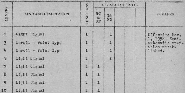 |


Above Left: In the center of this 1960 image
((c)historicaerials.com), the shadow of Tower 52 is visible as a black square.
The roof of the tower is also visible as a dark gray square slightly southeast of
(and significantly overlapping) the shadow.
By this date, the home and distant signals controlled by the interlocker were
automated. Above Right: This photo
was taken facing north-northeast at the site of Tower 52. The BNSF tracks cross
horizontally in the foreground with BNSF's spur to Quinif visible beyond,
heading north out of Cameron. (Jim King photo, c.2004)
Below: A gravel road (visible in the 1960 aerial image)
east of the tower and parallel to the Santa Fe tracks that was used by
operators to reach the tower remained sufficiently intact as of 2013 that the
Google Street View vehicle drove out as far as it could, blocked by a pile of
gravel. The view is due west; SP's line crossed at an angle here, somewhere near
the gravel pile, to join the ROW to Quinif to the right. Tower 52 was located
just beyond SP's tracks.


Above: Perhaps that's Tower 52
being depicted in the model train layout of Cameron located at the Milam County
Railroad Museum. Click the image to see the video. (courtesy, The Texas Bucket
List)