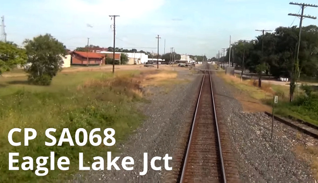
Texas Railroad History - Tower 115 - Eagle Lake
Crossings of the Galveston, Harrisburg & San Antonio, the San Antonio & Aransas Pass, and the Cane Belt railroads

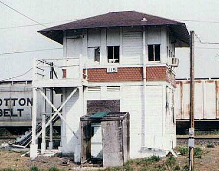
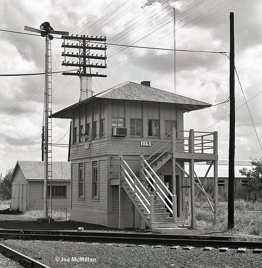
Above: This photograph
of Tower 115 was taken September 3, 1967 by H. D. Conner (Doug Jackson
collection.) The camera is facing southeast down tracks belonging to Southern
Pacific (SP) that continue to Houston, part of the
southern transcontinental Sunset Route. Signals in the distance pertain to a
crossing of the Gulf, Colorado & Santa Fe Railway about a third of mile from the
tower. Crossing on this side of the tower are SP tracks originally built by the San Antonio
& Aransas Pass (SA&AP) Railway. They proceed east (left) to
Bellaire Junction in Houston, and west (right) to Altair, beyond which
they are abandoned all the way to Yoakum. At far right, the Santa Fe depot lead
is visible parallel to the Sunset Route tracks. It comes off the Santa
Fe main (in the distance) and proceeds northwest, passing Tower 115, crossing the SA&AP
tracks (off the image to the right) and continuing 200 yards to the Santa Fe depot.
The building behind the tower
from this angle is a shed that houses a small
gasoline-powered cart used by maintenance personnel to travel to locations along
the tracks that are otherwise difficult to reach, typically to assess and repair
switch, signal or communications issues. The "driveway" between the shed and the
tracks is paved, here perhaps with a simple mixture of asphalt and aggregates, to
enable the cart to roll more easily to and from the tracks and to preclude the
development of low spots ("mud holes") that could make the ingress / egress more
challenging. The "decking" installed between the rails is similar to a wooden
grade crossing for a roadway. It makes the process of rotating the cart onto the
track easier by elevating the wheels closer to the rails.
Tower 115 was
built by SP in 1924 and authorized to commence operation by the Railroad Commission of Texas
(RCT). Tower 115's design had a
minor peculiarity in that the door to enter the second
floor was not on the same side of the tower as the staircase. This was
not typical, but there were a few towers with this feature (e.g.
Tower 94, Tower
121, and others.) Here, the landing wraps around to the back of the tower
where the door was located in the corner. (See back view at lower left.)
 |
Left: Tower 115 sits silently
abandoned as an eastbound freight train rumbles by on the Sunset Route
headed for Houston. The tower was razed shortly after this photo was taken. (Jim
King photo, November, 1996)
Right: Looking
west, the SA&AP tracks that originally passed beside the tower (as in
the photo above) have been removed. Instead, the tracks curve northwest
to join the Sunset Route. A connecting track for this purpose had been
in place for many years. To the east behind the camera, SP's former
SA&AP tracks were still intact to Houston when this photo was taken. (Jim King photo,
November, 1996) |
 |
The town of Eagle Lake,
adjacent to its namesake, was one of
the earliest railroad towns in Texas, eventually served by three different rail
lines. It was founded in 1859 as a settlement on the Buffalo Bayou, Brazos
and Colorado (BBB&C) Railway which had built west from the Buffalo
Bayou port of Harrisburg to the Colorado
River near Columbus. The Handbook of Texas
explains that Eagle Lake was intentionally founded as a railroad town when Gamaliel
Good bought 2,400 acres near the lake and...
"... subsequently deeded half interest in 600 acres to DeWitt Clinton
Harris, a director of the Buffalo Bayou, Brazos and Colorado Railway. Together
they planned the town to be a station on a new railroad between Harrisburg and
Austin."
Whether Harris had advance knowledge of the BBB&C's planned
right-of-way or perhaps was able to influence its route toward his land is undetermined,
but the railroad came through and continued thirteen miles farther northwest to
Alleyton near the east bank of the Colorado River.
The BBB&C did not plan to cross the river.
Its charter called for it to continue
northwest
along the east bank to La Grange and Austin,
but the Civil War interrupted
progress and the BBB&C built no further during the War.
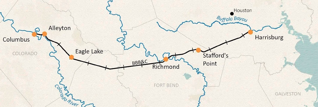 |
Left: BBB&C map, Texas General Land Office
The BBB&C went southwest
out of Harrisburg, crossed the Brazos River at
Richmond, and passed through Eagle Lake to
reach Alleyton
across from Columbus. Tracks between Alleyton and Columbus were built by
the Columbus Tap Railway, chartered by local citizens and then acquired
by the BBB&C, which bridged the Colorado River c.1867. Serving Columbus,
the county seat of Colorado County, was a fair trade for the cost of the
bridge, but it meant that a second bridge would be needed to return to
the east bank of the river to serve La Grange en route to Austin as
planned. The
railroad's subsequent decision to make San Antonio the objective
destination instead of Austin
rendered the second bridge unnecessary. |
The Civil War left the
BBB&C in poor shape physically and financially, and it was sold in 1870 to Thomas Peirce
(with the unusual ei
spelling.) Peirce was a wealthy businessman, landowner and lawyer who had done
legal work for the BBB&C before the War. Peirce owned a large sugar plantation
at Arcola, southwest of Houston near where the
BBB&C passed through Sugar Land. As Peirce
rehabilitated the railroad and improved operations, he petitioned the Legislature for a charter
revision to authorize construction west to
San Antonio instead of
Austin, and to rename the BBB&C the Galveston, Harrisburg & San Antonio
(GH&SA) Railway.
Peirce initiated GH&SA construction from
Columbus
toward San Antonio in April, 1873. He reached
Luling, 71 miles, by the
end of 1874, and completed the line into San Antonio in March, 1877, the first
railroad to reach Texas' second largest city. Peirce began to develop plans for
a line west to El Paso to connect with the
Southern Pacific (SP) Railroad which had begun building east from California
across Arizona. SP offered to finance the construction for Peirce, and the route was completed in January 1883
when Peirce drove a silver spike near the Pecos River. This signified completion
of a southern transcontinental route -- the Sunset Route, a marketing
identity Peirce had coined in 1874 -- between Los Angeles and New Orleans. SP leased the GH&SA and subsequently acquired it,
operating the route through Eagle Lake for just over a century until 1996 when
SP merged with Union Pacific (UP), which now operates the line.
 |
The second set of tracks into Eagle
Lake belonged to the San Antonio & Aransas Pass (SA&AP)
Railway, the end of a branch that would terminate with a Sunset Route
connection. In the spring of 1887 before the tracks reached town, a continuation to
Houston via Wallis
was negotiated with
Houston interests. The branch originated from SA&AP's main line at the tiny south Texas town of Kenedy, roughly midway between San Antonio and
Corpus Christi. Connecting those endpoints had been
the objective for SA&AP's founding in 1884. In 1886, SA&AP began expanding aggressively in all
directions: east to Eagle Lake from Kenedy, west to Kerrville from San Antonio, north to Waco
from Cuero (between Kenedy and Eagle Lake) and south to Alice from Skidmore
(between Kenedy and Corpus Christi.) After being reorganized during a
receivership that ended in 1892, SA&AP resumed independent operation, but it was
closely aligned with SP (a bit too close for RCT; see
Tower 2.) SA&AP was acquired by SP in 1925, and the Alice branch was
extended to Edinburg shortly thereafter.
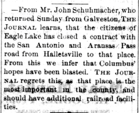
Left: The
La Grange Journal of February 17,
1887 was disappointed to learn that SA&AP's northeast extension from
Kenedy to Hallettsville would continue to Eagle Lake instead of
Columbus, leaving the latter with only the Sunset Route tracks. La
Grange had experienced a similar disappointment in the early 1870s when it appeared that the Legislature would approve
Peirce's request to change the GH&SA's endpoint from Austin to San Antonio, leaving La Grange
without the railroad service it had been expecting. Local legislators
objected vigorously, and the Legislature's final
approval of Peirce's charter revisions became contingent on his
agreement to build a branch from Alleyton to La Grange. The branch was built in 1881 and abandoned
in 1942. |
The third railroad at Eagle Lake
was founded by local
investors in 1898, with William Dunovant named President. It was called the Cane Belt Railroad,
and the plan was to build
from Lakeside, a tiny community one mile south of Eagle Lake, to Bonus, about ten
miles farther south. Dunovant owned a large plantation at Bonus; sugar cane was
among the crops he grew there. To serve a planned sugar cane
refinery, the GH&SA had built a spur into Lakeside which the Cane Belt was
able to acquire and extend south to Bonus. In 1900, the Cane Belt
continued the line south from
Bonus to Wharton and also built an 18-mile connection
from Eagle Lake northeast to Sealy. The
tracks to Sealy provided the Cane Belt with
connections to two major railroads, the Gulf,
Colorado & Santa Fe (GC&SF) Railway and the Missouri, Kansas &
Texas ("Katy") Railway. The sugar cane refinery at
Lakeside had begun producing as much as five million pounds of sugar
annually, so the railroads at Sealy provided competition for the GH&SA
and SA&AP at Eagle Lake for outbound shipments of refined sugar.
Right: In late 1903, the Cane Belt was acquired by the
Atchison, Topeka & Santa Fe Railway, parent company of the GC&SF. (Grapevine Sun,
November 28, 1903)
In 1905, the Legislature approved Santa
Fe's plan to lease the Cane Belt to the GC&SF. The Cane Belt continued
to operate under its own name until 1948 when it was fully merged into the GC&SF. |
 |
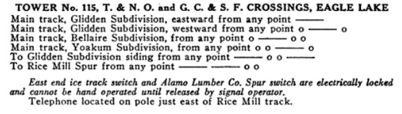
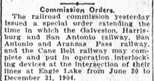 |
The three railroads at Eagle Lake had been put under a June 30, 1904 deadline
by RCT to interlock their
crossings. The three bilateral crossings
formed a right triangle, and they were far enough apart (between
0.32 and 0.46 miles) that it would be difficult with prevailing
technology to interlock all three with only one tower. The general rule
at the time was that tower operators needed to be able to see trains
approaching a diamond, but a tower near any one of the three diamonds meant
worse visibility for trains near the other two. A single tower placed to minimize
the total distance from all three diamonds would still be nearly a
quarter mile from each of them. How the railroads managed to resist
RCT's order is undetermined, but this news item shows RCT
granting a six months' schedule extension. Twenty years, not six months, would have
been more appropriate!
Left:
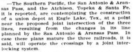
Austin Statesman, May 26, 1904 |
| Right:
The September 3, 1910 edition of The
Railway and Engineering Review carried this note regarding a
union depot proposed for Eagle Lake. The depot was to be located "near
the proposed joint intersection of the three lines." Such intersection
would apparently result from "changes in its line planned by the San
Antonio & Aransas Pass." What those changes might have been is
undetermined, but they would also have led to a "joint interlocking
system" which, despite RCT's earlier order, had never been built.
The railroads' main lines never had a "joint intersection" at Eagle
Lake, and thus, there was never a union depot. In 1911, Santa Fe built a
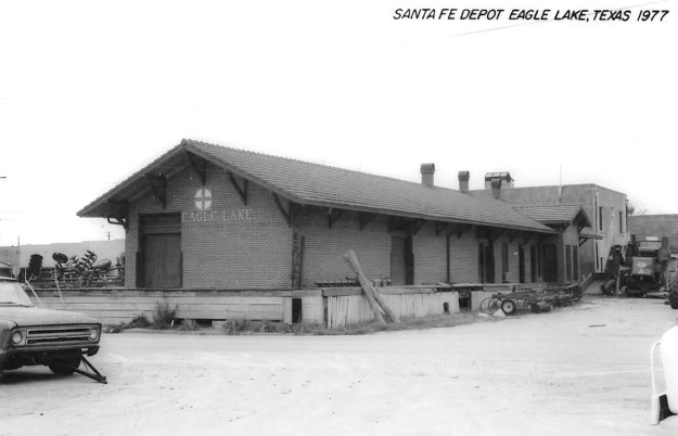
combo freight and passenger station close to downtown accessed by a depot lead track. |
 |
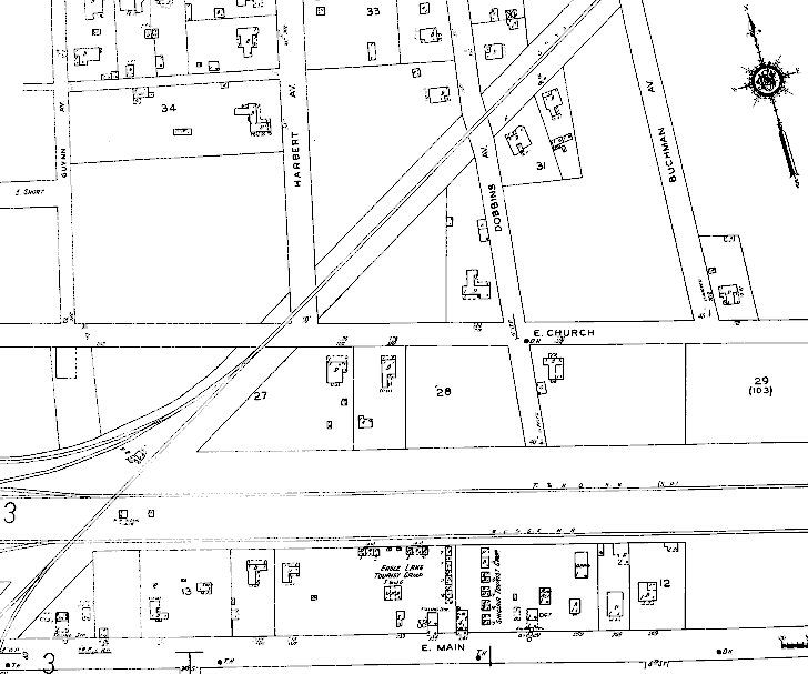
Below and
Right: These images are from the September, 1922 Sanborn
Fire Insurance map of Eagle Lake. Although the gap between these two map
snippets should be larger, and
their scales are not precisely the same, they reasonably represent the
locations of the three passenger depots in Eagle Lake relative to each
other.
 |
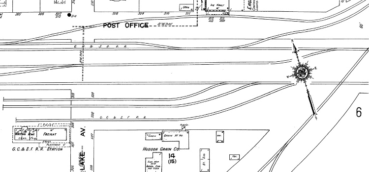
Above:
The map shows the Santa Fe depot in the lower left corner, about 150
yards southeast of the GH&SA passenger station (top of left map.)
The Santa Fe depot was accessed
by a spur track that connected to Santa Fe's main line near the GH&SA crossing. Coming northwest into downtown, the depot lead
crossed the SA&AP close to Tower 115, which was built and commissioned a
couple of years after the map was drawn. The tower's future site was
located above the numeral '6' on the far right side of the map, inside the right triangle formed by the
SA&AP, the Santa Fe depot lead and the right edge of the map. The Santa Fe
depot has been preserved and is now the
Eagle Lake Depot Museum.
Left: The GH&SA's separate freight and passenger stations are
depicted at the top of the map sitting trackside along the GH&SA
main line. A GH&SA / Santa Fe exchange track passes south of the depot
adjacent to the Public Square.
About 200 yards southwest of the
GH&SA passenger depot, the SA&AP combo freight and
passenger depot sits at the bottom of the map along the north
side of the SA&AP main line. About two and a half years after this map
was drawn, SP acquired SA&AP. Trains
on the SA&AP tracks eventually began using the GH&SA depots via
depot leads and yard tracks accessed from the connecting tracks at the Tower 115 crossing.
In
1927, SP leased the GH&SA and SA&AP to the Texas & New Orleans
(T&NO) Railroad, SP's principal operating company for Texas and
Louisiana lines. The 1932 Sanborn map identifies the GH&SA depots as T&NO
facilities and shows that SA&AP's depot had been converted to a
warehouse. The GH&SA was merged into T&NO in 1934. |
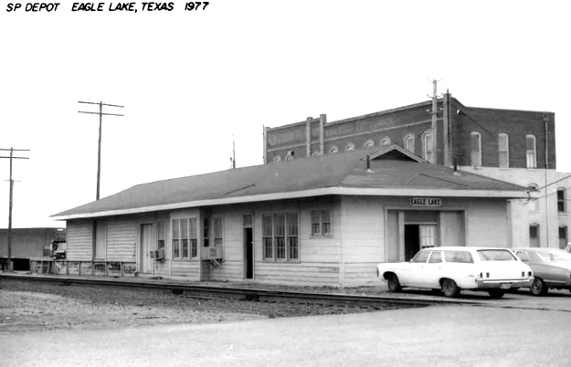
Above Left: The SP depot was
photographed by H. D. Conner in 1977. Between 1938 and 1956, SP expanded the passenger depot
to incorporate the freight depot functions. The freight depot was eventually dismantled.
Above Right: The Santa Fe
depot, built in 1911, also was photographed by H. D. Conner in 1977. (both
images, Chino Chapa collection)
 |
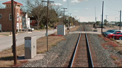 |
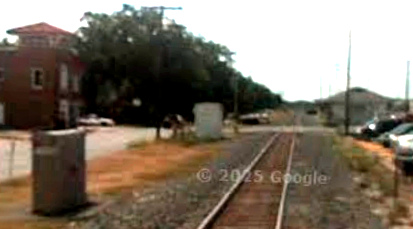
Far Left
(2008) and Left
(2013): When Google Street View got started in 2008, the camera car
unfortunately did not cover all of the streets in downtown Eagle Lake.
However, its view from McCarty Ave. southeast along the Sunset Route did
capture the SP depot building one block away sitting on the south side
of the tracks beside the Commerce St. grade crossing. By 2013, it was
gone. |
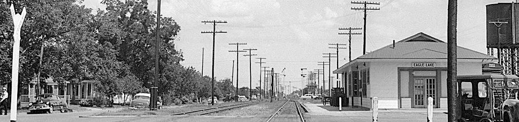
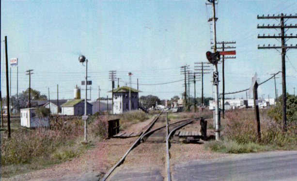
| Right:
This image comes from a larger photo taken by Joe McMillan in 1953. The
camera is facing southeast down the Sunset Route with Tower 115 barely
visible along the right side of the tracks in the distance. The SP depot
is at right. |
 |
 |
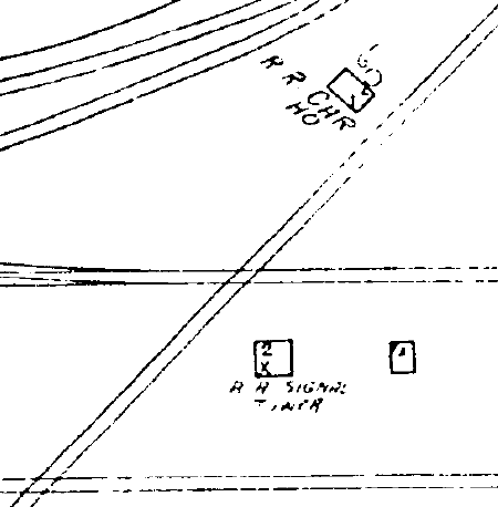
Left:
The 1932 Sanborn map shows Tower 115 sitting between two parallel tracks:
the GH&SA (T&NO) main line (north) and the Santa Fe depot lead (south). SA&AP's track
crosses the other two at a 45-degree angle.
Above:
Magnification reveals the cartographer's depiction of Tower 115 as a
two-story "R R Signal Tower." |
Tower 115 was built by
SP and commissioned by RCT most likely on July
22, 1924. In a table dated December 31, 1923,
RCT identifies Tower 115 as a 77-function electrical interlocker at Houston
Yards commissioned on March 14, 1924 (a date in the future!) serving the
Houston Belt & Terminal (HB&T) Railway.
Tower 116 is shown with identical
information. This was an obvious corruption, but the following year,
there was yet another corruption; Eagle Lake was listed as the
name of the Tower 115 railroads, still at Houston
Yards!
A year later, the RCT table dated December 31, 1925
finally shows Tower 115 at Eagle Lake, commissioned on July 24, 1924 with
a 47-function electric interlocker serving the GH&SA, GC&SF and SA&AP railroads.
The following year, the Tower 115 entry was revised to 54 functions and the
commissioning date was moved back two days to July 22, 1924. This information
remained unchanged through December 31, 1930 after which RCT no longer published
an annual interlocker list.
Right:
This view of Tower 115 was taken in November, 1976 looking west on the
SA&AP line. By the time of the 1996 photo at top of page, the
connecting track leading off to the right was the only track, and the SA&AP
had been abandoned past the tower. (Doug Woods photo, courtesy of David Bernstein) |
 |
 |
Left: Joe
McMillan returned to Eagle Lake and photographed Tower 115 on September
19, 1972. Joe is standing on or near the Sunset Route tracks looking
south. SP's former SA&AP tracks pass in front of the staircase, and the
Santa Fe depot lead is barely visible off to the right. The maintenance
shed appears unchanged from the 1967 view (top of page.)
Above: A 1942 T&NO Employee Timetable (ETT)
provides this set of whistle codes for the Tower 115 operators. SP had a
yard and maintenance base at Glidden on the western outskirts of
Columbus, and the Glidden Subdivision ran from there east through Eagle
Lake to Houston. T&NO's Bellaire Subdivision was simply SA&AP's Bellaire
Branch between Eagle Lake and Houston. SA&AP's tracks west of Eagle Lake
became the T&NO's Yoakum Subdivision. This same ETT confirms that
connecting tracks at Tower 115 were used for access to the T&NO depot by
trains on the Bellaire and Yoakum Subdivisions. Regarding the movements
of motor cars "...No. 309 and 310 to and from the passenger station at
Eagle Lake ... transfer and siding must be kept clear. Trains will move
with caution within Eagle Lake yard limits expecting to find main track
occupied." |
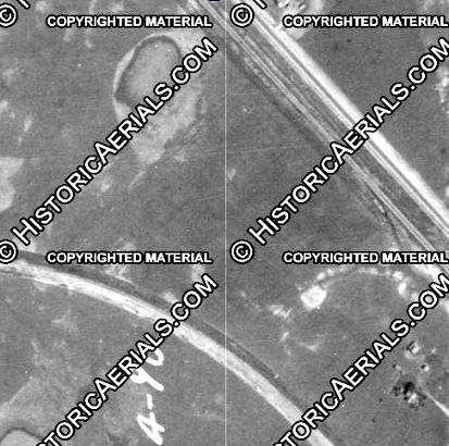
Above: (all images (c)
historicaerials.com) On the north side of Eagle Lake, the GH&SA and SA&AP
tracks became parallel on a southeast heading for a mile prior to SA&AP's crossing
of the GH&SA at Tower 115. This 1938 image (left)
shows the two lines were about 850 ft. apart across open land (GH&SA upper
track, SA&AP lower track.) With SP having acquired SA&AP in 1925, this location provided an
excellent spot to build a new connection, at least by 1956 (center.)
Between 1981 and 1995, the SA&AP tracks through Eagle Lake were abandoned
between this connection and Tower 115. By 2004 (right)
under UP ownership, an additional connection was put in place to support direct access to and
from the southeast direction on the Sunset Route.
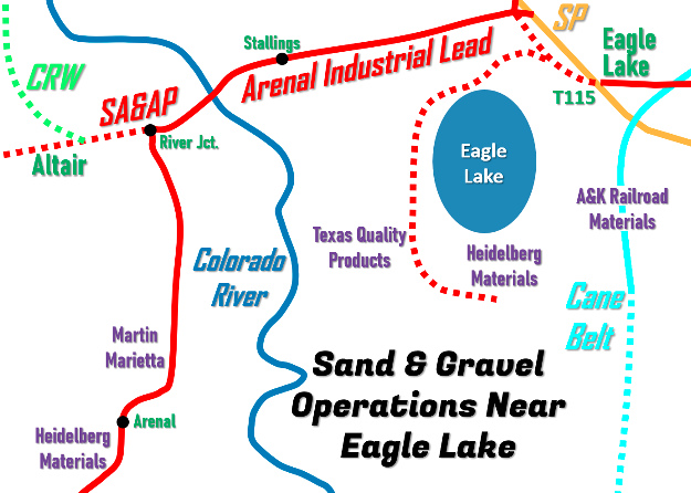 |
Sand and gravel operations began to
establish mines near Eagle Lake served by rail. By 1930, a spur off the SA&AP near downtown had been built to the west and south, passing along the west side of the lake
but remaining east of the Colorado River. A nearby "Parker Rd." suggests that
this line may have served a sand and gravel operation owned by the Parker Brothers of
Houston who had mining interests in Eagle Lake. The spur was eventually removed,
but sand and gravel operations continue along Pioneer Plant Rd.,
portions of which sit atop the abandoned grade.
Near Altair, seven miles west of Eagle
Lake, a spur was built
north to Helms in 1955 by the Colorado River Western (CRW) Railroad to
serve a large sand and gravel mine on the west bank of the river. This
spur was purchased three years later by SP and operated until it was
abandoned in 1975. Another mine was active by 1956 along the north side of the SA&AP tracks
at the west
bank of the river.
By 1965, the former SA&AP tracks west of
Altair had been abandoned as far as Yoakum. Service to Altair was retained to support
various mines and the CRW. Between 1964 and 1969, a 2.7-mile track south of Altair was built to serve a sand and
gravel operation. It was extended five miles farther south to serve another
mine. By 1969, a short gravel spur at Stallings had been built east
of the river, about 4.4 miles west of Eagle Lake.
The former
SA&AP line west from Eagle Lake is now known as the
Arenal
Industrial Lead, departing the Sunset
Route at the connection on the north side of town discussed above. It turns south just before reaching Altair.
At present, sand and gravel operations owned by Martin
Marietta and Heidelberg Materials are served by the spur. |
Matthew Dittert fills in some details about the Arenal
Industrial Lead:
In
regards to the line built in the 1970's to reach new rock pits (including Arenal)
south of the SA&AP west of the Colorado River, here are some clues as to when
the line was built.
"Arenal" does not appear in SP San Antonio and
Houston Division ETT #2 which went into effect June 13, 1971 but does appear in
SP Houston Division ETT #201 which went into effect June 11, 1972.
Arenal appears as a station at MP 67.9 on the
Bellaire Branch 2.3 miles west of Stallings.
There is an asterisk next to "Arenal" directing
attention to a note that reads "Arenal is on spur track 6.16 miles from Lead
Switch."
The latest ETT that I have listing Arenal in similar
fashion is SP/SSW Eastern Region ETT #2 which went into effect November 20,
1985.
I do not have the three ETT's that followed #2, but I
have #6 (effective date: May 15, 1988), which no longer has the Bellaire Branch
extending west of Eagle Lake.
Instead, ETT #6 has the Arenal Industrial Lead
with "River Junction" at MP 0, located 2.2 miles west of MP 65.6, the location
of Stallings.
Arenal is shown to be at MP 5.0.
East of Eagle Lake, the SA&AP
Bellaire Branch to Houston was
abandoned in 1993 so that it could be conveyed to an entity that was
not a common carrier, the Metropolitan Transit Authority of Harris County
("Metro"). However, SP retained an operating easement on the line to continue
to provide service. Acquiring SP in 1996, UP planned to continue service until 2001. Meanwhile, a request to
"rail bank" the right-of-way was made by Metro. The Surface Transportation
Board granted a Certificate of Interim Trail Use in November, 2000 covering the
right-of-way from Milepost 3.48 near Bellaire Junction at Houston
to Milepost 52.9 located 8.3 miles east of Eagle Lake. The remaining track into
Eagle Lake became the Chesterville Industrial Lead as an 8-mile spur
off the Sunset Route. In 2001,
Metro and UP agreed to rail bank the right-of-way. Metro retained the right to
re-install tracks and
reopen service on the former Bellaire Branch except for the final eight miles,
the Chesterville Industrial Lead.
In 2008, UP sought to abandon the
Chesterville Industrial Lead. To do so, UP and Metro agreed to a transfer of
rights, officially restoring common carrier service so the tracks could formally
be abandoned. The tracks were left in place but the connection to the Sunset
Route was severed. In 2014, Metro acquired the restoration rights to the
Chesterville Industrial Lead, giving it such rights for the entire Bellaire
Branch. The Chesterville Industrial Lead is still disconnected from the Sunset
Route, but its tracks remain intact, the only ones in place on the former Bellaire Branch.
Above Left: This image captured
from a
YouTube video shot looking northwest from the rear of an eastbound Amtrak train in 2014 shows that the Sunset
Route connection to the Chesterville Industrial Lead
at lower right is no longer intact. The railcar from which this image was
captured is passing over the former site of the Tower 115 diamond. The former Santa Fe depot
is the
brown building to the left, home of the Eagle Lake Depot Museum. Above
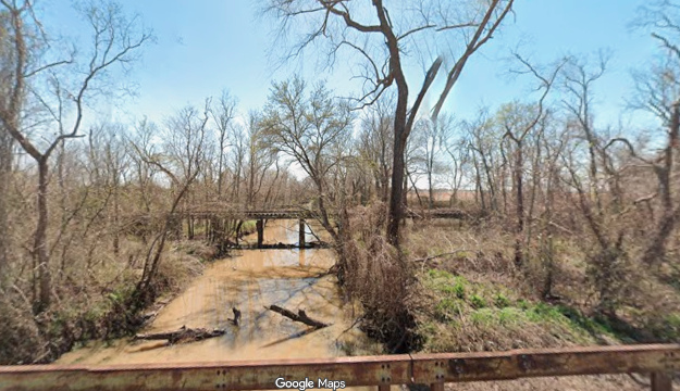
Right: Looking south from FM 1093, the tracks remain in place at
the east end of the Chesterville Industrial Lead, just over eight miles from the
severed Sunset Route connection. They terminate at the east
(left) end of this bridge over Middle
Bernard Creek. The Chesterville Industrial Lead almost exclusively traversed
farm land, much of it dedicated to rice farming. Large rice silos
near the end of the spur may have been the motivation for retaining service when
the Bellaire Branch was abandoned. (Google Street View, March, 2025)
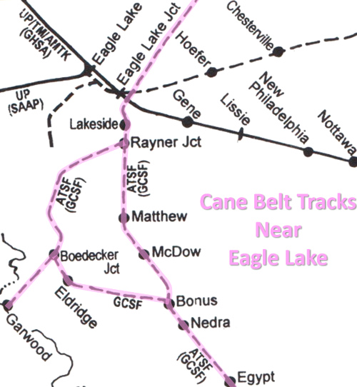 |
Left: map of Cane Belt
lines near Eagle Lake ((c) Mike Walker, SPV)
The Lakeside Sugar Refinery provided the
original purpose for the founding of the
Cane Belt. When the
Texas Legislature
in 1909 banned state prisons from leasing out convict labor, a practice the sugar
companies had come to rely on for manually intensive field work, the Texas
sugar industry began to decline. The Lakeside refinery site was abandoned in 1918.
Today, it is occupied by A&K Railroad Materials, a
nationwide supplier to the railroad industry, and is served by UP on the
former Cane Belt tracks. Although the map depicts the tracks to Lakeside
as abandoned, A&K's yard is accessible from a connection to the Sunset
Route at the former Cane Belt / SP crossing. Storage tracks extend south
from the A&K yard for three quarters of a
mile, but the Cane Belt is abandoned farther south.
The Cane Belt's Bonus Loop
tracks to Eldridge and Garwood were abandoned between 1940 and 1961. The main line south
to Wharton and
Bay City survived into the 1980's before
abandonment by Santa Fe in various phases.
After the
Cane Belt line northeast to Sealy was abandoned in 1990, Tower 115 was decommissioned.
Above: As
viewed from Beaks Ave., access onto the eastbound
Sunset Route from the A&K Materials spur is governed by a dwarf signal
(Google Street View, March, 2025.) |
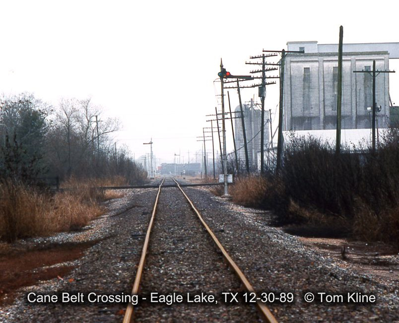
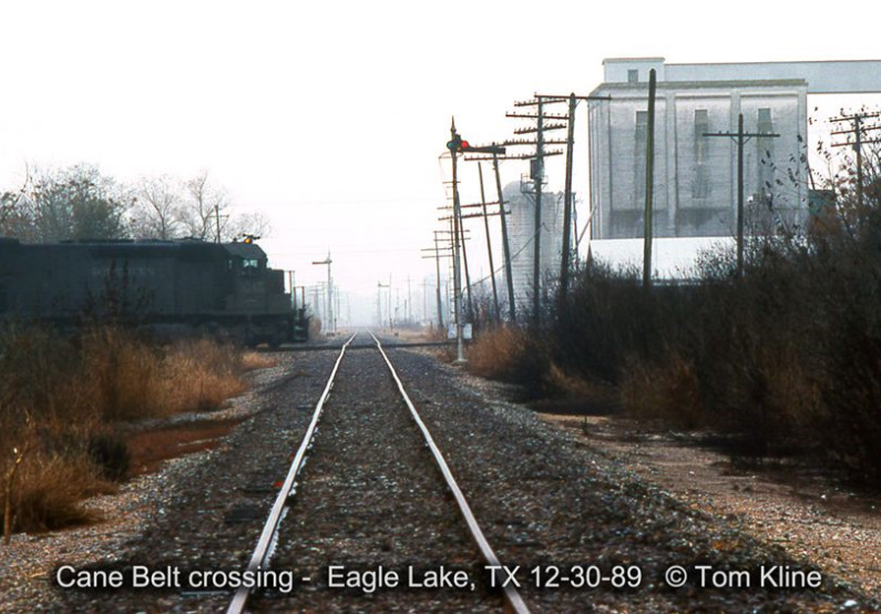
Above: Tom Kline visited Eagle Lake in 1989 and took these photos along the Cane
Belt tracks. Tom discusses what he saw: "In both photos you are looking south-southwest [along
the Cane Belt] with Sealy being behind the camera.
The left
photo shows a stack train crossing the Cane Belt in the distance on
the SP Glidden Sub as it heads to Houston. The
right
photo
shows a westbound crossing the Cane Belt on the SP Bellaire Line heading towards Tower 115 right after the
eastbound stack cleared the interlocker. This train is arriving from Houston on
the Bellaire Line back when it was used as the
high speed shortcut to Eagle Lake."
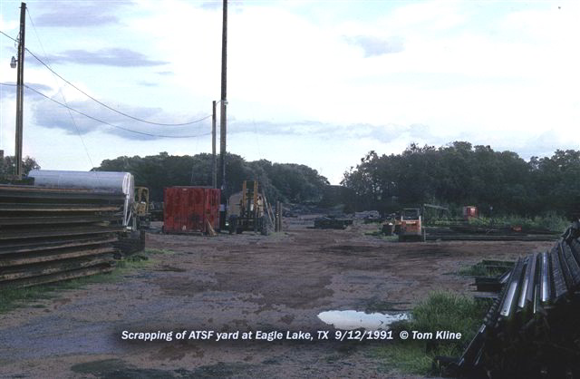
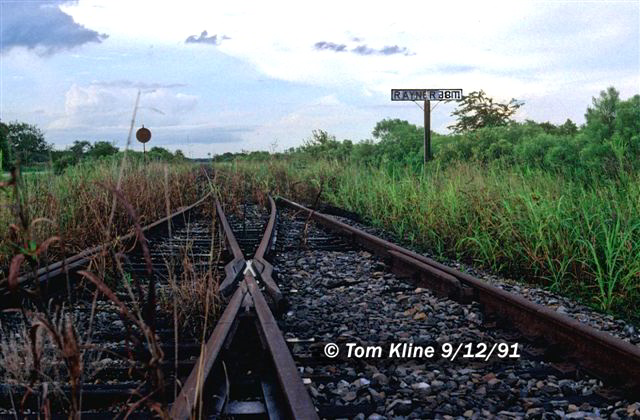
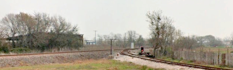
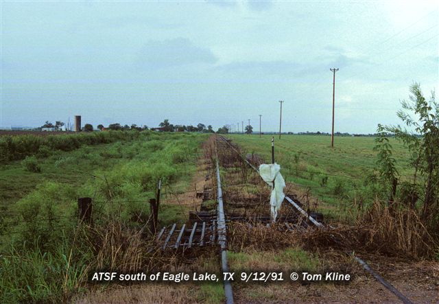
Above: Tom returned to Eagle Lake in September, 1991. What he found was the
Santa Fe yard being
scrapped (left) and weeds overtaking the Cane Belt route at Rayner Junction
(right.) Tom explains..."Rayner
Junction was located
about 2 miles S/SW
of Eagle Lake on FM 102. Here the line branched off to the west to Matthews and
Garwood. To the
left in the photo you can see FM 102 and the crossing warning sign for
the spur. This view is not far from the historical roadside marker about the Lakeside
Sugar Refinery just south
of Eagle Lake. Farmers have reclaimed the right of
way south of town by
fencing over the rails."
Below Left: Tom photographed a fence over the rails...
"This view is north towards Eagle Lake and
Egypt. Wharton
and Bay City are behind us; Rayner Jct. is ahead of us."
The white plastic is attached to a fence stake, presumably to warn any wayward
trains that might venture into the area.
Below right:
This Google Street View from January, 2013 looks north along the Cane Belt
right-of-way at the south end of the storage tracks located south of the A&K
Materials yard. Four of the five tracks are filled with hopper cars. A Street View from March, 2025 shows all of the tracks
empty, but a satellite view from October 18, 2024 shows three of the five tracks
filled with hopper cars. The Street View camera is looking north from Senior
Bridge Rd. at the Cane Belt right-of-way crossing, about 0.4 miles north of
Rayner Jct.

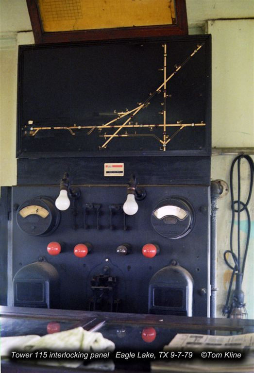
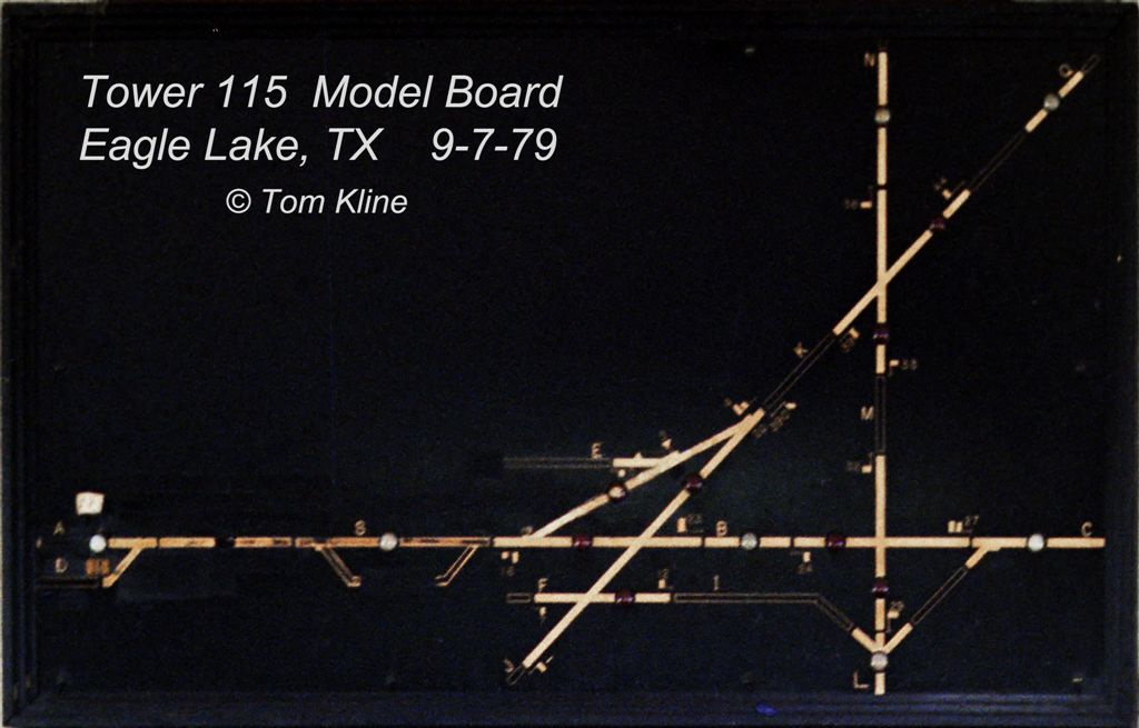
Above: Tom Kline took these photos of the Tower 115 Model Board
in 1979. A yellow square has been superimposed onto the image to show the location
of Tower 115. The horizontal line is the Sunset Route. The vertical line is the
Cane Belt. The diagonal line is the SA&AP. The horizontal line below the
tower is the Santa Fe depot lead.