Texas Railroad History - Tower 134 - Houston (Pierce
Junction)
A Crossing of the Galveston, Harrisburg & San Antonio Railway
and the International & Great Northern Railroad
Above:
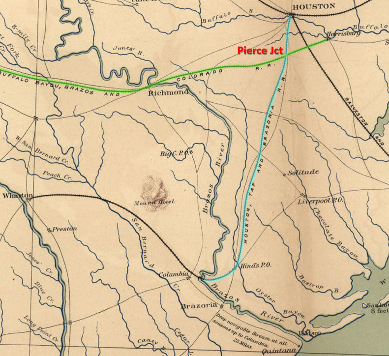
This image taken from an 1865 map has been annotated to highlight two railroads: the Houston Tap & Brazoria
Railway (HT&B, blue) and the Buffalo Bayou, Brazos & Colorado Railway
(BBB&C, green). The settlement that grew up around the crossing of the two
railroads became known as Pierce Junction. Although the HT&B charter planned for a crossing of the
Brazos River at Columbia, neither the bridge nor the extension to Wharton was
ever built. The HT&B terminated at East Columbia on the east bank of
the river, and the town of Columbia (the first capital of the Republic of Texas)
eventually became known as West Columbia. The close association of the HT&B with
this important river port led to the railroad being nicknamed "Columbia Tap", a
title that has persisted more than 150 years. (from the
Atlas to Accompany the Official
Records of the Union and Confederate Armies. Washington, DC: Govt. Print.
Off., 1895, courtesy of the Texas Transportation Archive)
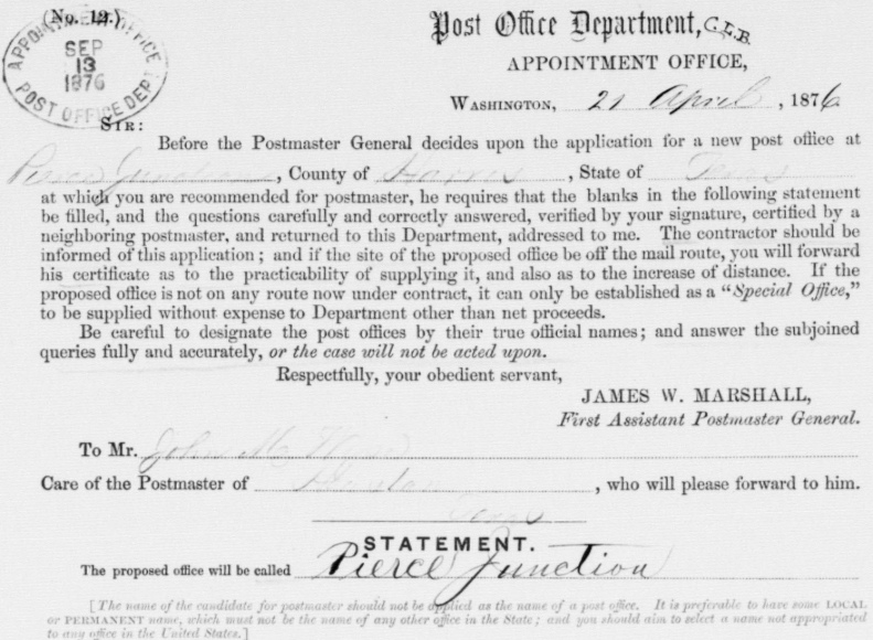
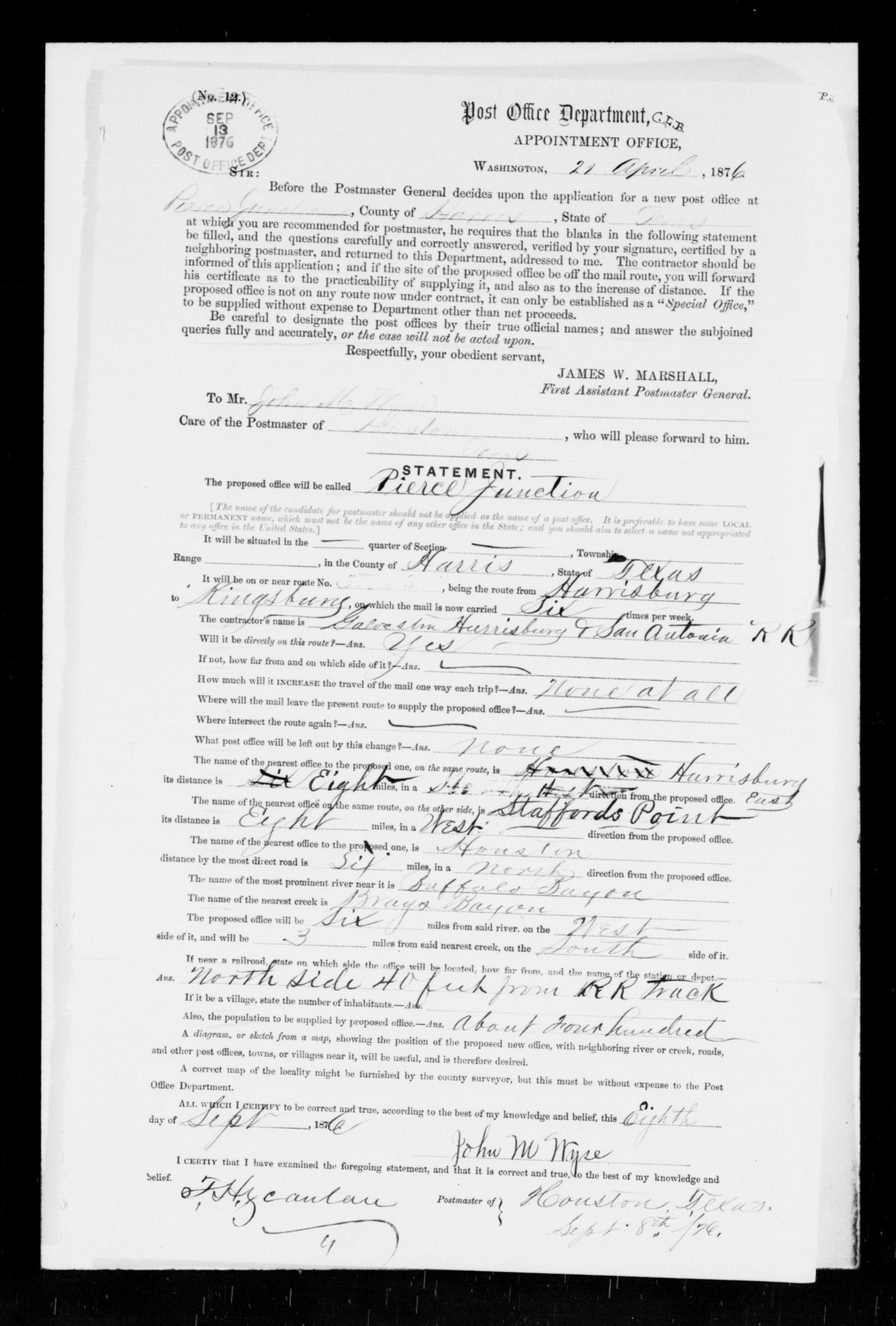
Below: The top portion of the
one page application for a post office at
Pierce Junction shows that it was initially filled out on April 21, 1876.
After the form was completed, certified and mailed to the Post Office
Department, its Appointment Office stamped its receipt of the application
on September 13, 1876. (National Archives)
The first railroad in Texas, the Buffalo Bayou, Brazos
and Colorado (BBB&C) Railway, began construction in 1851 at
Harrisburg, a small port on Buffalo Bayou
a few miles downstream from Houston. The objective
was to build west to the vicinity of the Colorado River near Columbus. From
there, the railroad would build north
and west,
following the river to La Grange and Austin but never crossing it. The endpoint for the first track segment
(completed in 1853) was Stafford's Point (now the Houston suburb of Stafford), approximately
twenty miles west of Harrisburg. By 1855, twelve additional miles had been built
to Richmond, the county seat of Fort Bend County, on the west bank of the
Brazos River. As traffic on the BBB&C increased, merchants in Houston noticed
that much of the trade brought into Harrisburg by rail was going south on
Buffalo Bayou to Galveston rather than north on the bayou to Houston. They
successfully pursued having the Legislature amend the BBB&C's charter to
authorize the City of Houston to issue bonds for a rail line to "tap" the BBB&C.
Funded by Houston's bond money, construction of the Houston Tap Railroad
commenced in April, 1856 and operations began in October. The
connecting point of the two railroads was 6.5 miles south of Houston, and was known
simply as "Junction", the first railroad junction in Texas.
Owners of the
vast sugar and cotton plantations south of Houston realized that an extension of the Houston Tap's
rails south from Junction would give them the transportation options they
sorely lacked. Thus, before the Houston Tap had even begun operations, the
Houston Tap & Brazoria (HT&B) Railway was granted a charter by the Legislature
authorizing it to acquire the Houston Tap and extend its rails south to
Columbia. Columbia was a major port on the Brazos River close enough to the Gulf
of Mexico (about 23 river-miles at the time) that navigation by ocean-going
steamships was generally feasible year round. The acquisition was consummated in
June, 1858 and
HT&B trains were operating to Bonney, 25 miles south of Junction, by the end of the
year. Rails reached East Columbia in 1860, about 45 miles south of
Junction. East Columbia was on the east bank of the Brazos River across from
Columbia, the first capital of the Republic of Texas. The close association of
the HT&B with Columbia resulted in the rail line's nickname, "Columbia Tap",
which has persisted to the present day. With rail service, East Columbia's
population and commerce grew, gradually causing Columbia to become identified as
West Columbia. In 1873, the HT&B was acquired by the International & Great
Northern (I&GN) Railroad, the largest railroad in Texas at the time, but the
rails never crossed the Brazos into West Columbia.
At Arcola, thirteen miles south of Junction, Thomas W. Peirce
owned a large sugar plantation. Peirce was a wealthy mercantile businessman and attorney from
Boston who used the uncommon ei spelling of his last name. The Columbia
Tap gave Peirce's plantation access to barges and steamboats at East Columbia,
and also provided a route to the port of Harrisburg via the connection with the
BBB&C at Junction. Since much of his wealth had been derived from exporting
Texas products, particularly cotton and sugar, Peirce had become interested in
the development of railroads in Texas. By 1857, he had become a director of the
Houston & Texas Central (H&TC) Railway and had also performed legal work for the
BBB&C.
Although
the BBB&C had built 48 miles beyond Richmond to the tiny community of Alleyton
three miles east of the Colorado River, economic malaise during Reconstruction
put the railroad into receivership. In a lawsuit for non-payment, the contractor that had
built it, William Sledge, acquired the BBB&C and then made a valiant attempt to continue
its operations and restart construction toward La Grange. Peirce saw an
opportunity, and in 1870, he formed a small investor group that purchased the
BBB&C from Sledge. He petitioned the Legislature to modify its charter to
authorize building to San Antonio instead of La
Grange. Although the charter retained a requirement to build a branch line
to La Grange (which Peirce fulfilled in 1881), the Legislature granted his
request to build to San Antonio. Peirce also asked that the
railroad's name be changed to the Galveston,
Harrisburg and San Antonio (GH&SA) Railway. Peirce bought out most of the other
investors and initiated construction westward. As part of his efforts to publicize his
railroad, Peirce coined the term "Sunset
Route", a name still in use today.
 Newspapers
began referencing the GH&SA as "the Peirce Line"; the community
that grew up around Junction appears to have begun using the name "Peirce Junction"
as a result. The
earliest appearance of
"Peirce Junction" in the Galveston Daily News
("Circulation More Than Double That Of Any Paper In Texas") is September 8, 1874.
Both "Pierce Junction" and
"Pierce's Junction" (using the normal spelling) also began to appear in the
Galveston newspaper but not before July 3, 1875.
Newspapers
began referencing the GH&SA as "the Peirce Line"; the community
that grew up around Junction appears to have begun using the name "Peirce Junction"
as a result. The
earliest appearance of
"Peirce Junction" in the Galveston Daily News
("Circulation More Than Double That Of Any Paper In Texas") is September 8, 1874.
Both "Pierce Junction" and
"Pierce's Junction" (using the normal spelling) also began to appear in the
Galveston newspaper but not before July 3, 1875.
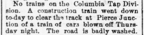
Left: The
Galveston Daily News of Sept. 21, 1875
reported on the aftermath of a storm at Pierce Junction.
The Peirce Junction name had probably been in use for only a couple of
years when John M. Wyse filled out the official application requesting a new
post office for "Pierce Junction". The handwriting is consistent
throughout the application, suggesting that
Wyse personally entered the normal spelling of "Pierce". Whether he did so of
his own volition or as a result of a community-wide decision is lost to history.
Wyse dated the application April 21, 1876 and answered a series of questions
pertaining to the location of the proposed post office and the populace it would
serve. Wyse was required to have the application certified by the postmaster at
the nearest post office, Houston, which was accomplished on September 8, 1876. It was mailed to the Post Office Department,
which stamped it as received by the Appointment Office on September 13. Among the details supplied by Wyse on the completed
application... the Contractor that operated the mail route was the GH&SA; the post
office would be located "north side 40 feet from RR track"; and the population
to be served numbered "about four hundred." The post office
was granted, but it lasted on a couple of years before being decommissioned,
presumably for insufficient activity.
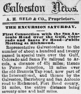 |
Left:
The author of this article in the Galveston Daily
News of April 30, 1878, didn't get the memo. A year and a half after
the Pierce Junction post office had been granted, the reporter still
used the "Peirce" spelling when describing the route of a special
excursion train out of Galveston. The Gulf, Colorado & Santa Fe
(GC&SF) Railway had finally reached
Arcola, reason enough for 120 "Representative Galvestonians" to
celebrate with an excursion. The
reporter explains that the train turned north at Arcola, went
13 miles to "Peirce Junction", and then turned west and proceeded to
Richmond on the GH&SA, the terminus of the day's trip. At Arcola,
the GC&SF would eventually build across the Columbia Tap (called
"Brazoria Tap" in the article) and continue west to Richmond and beyond, founding
Rosenberg in the process.
The improper
"Peirce" spelling no longer appeared in the
Galveston Daily News after
September 25, 1888. |
The GH&SA's rails reached San Antonio in 1877, and
within a year, Peirce and Southern Pacific (SP) Chairman Collis Huntington were
discussing a potential partnership regarding the line SP was building east from California to
Yuma, Arizona. Huntington had decided that SP construction would continue past Yuma all the way
to El Paso, and he had obtained permission from the territorial governments of
Arizona and New Mexico to do so. Huntington wanted to create a southern
transcontinental route close to Mexico via El Paso and San Antonio that would also
serve Gulf ports at Houston and New Orleans. This required building 800 miles
across Texas, but SP did not have a charter from the State of Texas. The chances
of getting one were poor; the other major railroads in Texas would
fight it vigorously in the Legislature. Hence, Huntington's attention turned to
the GH&SA. The GH&SA had a Texas railroad charter, and due to an
innocuous provision added by Peirce when the charter was amended, the GH&SA was already authorized to
build as necessary to connect with any
Pacific railroad. The tracks to San Antonio covered 200 miles of the
distance between El Paso and Houston, and the GH&SA had rights to operate into downtown
on the Columbia Tap. Peirce had everything Huntington needed except
tracks between San Antonio and El Paso. Huntington and Peirce agreed that SP
would
loan the GH&SA the funds to build between those two points,
and that
Peirce would contract with SP's Southern Development Co. to field construction
forces working east from El Paso. Their work began in June, 1881 under the GH&SA
charter while Peirce's own construction forces built west from San Antonio.
After a bit more than a year and a half, the two railroads met at the Pecos
River on January 12, 1883 where Peirce drove a Silver Spike
signifying completion of a major portion of SP's southern transcontinental rail
line. SP leased the GH&SA for several years before acquiring it.
Huntington's plan for SP's southern transcontinental route across Texas had
ramifications for traffic at Pierce Junction. Huntington needed to transition
all the way across Houston to connect with the rails he was planning to acquire
that ran from Houston to Beaumont and beyond (the
Texas & New Orleans Railroad.) Before work on the San Antonio - El Paso segment
even began, Huntington convinced Peirce to build a GH&SA branch line directly
into Houston. This would eliminate dependence on the Columbia Tap, but more important, the route into Houston could be chosen
for maximum compatibility with the yards north of Buffalo Bayou where SP
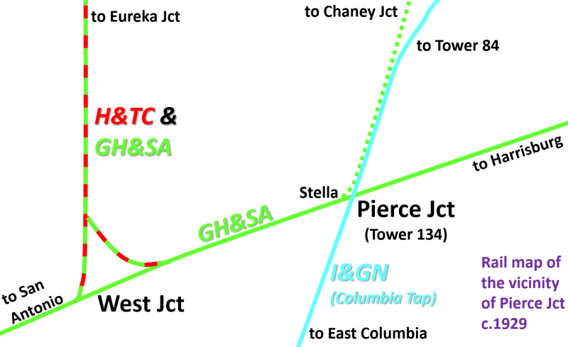
intended to base their southeast Texas operations. Thus, in 1880, the GH&SA
built its own line into Houston from a point immediately west of Pierce Junction
called "Stella". The line proceeded north parallel to the Columbia Tap and
maintained a straight, north-northeast heading for 3.6 miles before turning to a
north-northwest heading and crossing the San Antonio & Aransas Pass (SA&AP) Railroad at
Blodgett Junction. Farther north, the GH&SA crossed
Buffalo Bayou and intersected with the H&TC at grade at "Chaney
Junction". From there, it curved east toward downtown where the GH&SA
was sharing the H&TC passenger depot. SP proceeded to acquire the H&TC
in 1883.
With the GH&SA no longer using the I&GN tracks to reach Houston,
the SP trains that passed through Pierce Junction were mostly those
coming from (or destined to) Harrisburg or Galveston. The massive hurricane of
1900 had wiped out two of the three rail bridges onto Galveston Island, seriously
impacting rail traffic for many years. In 1912, the
Galveston Island Causeway opened, carrying rails shared by several railroads including the GH&SA. As traffic increased to normal levels and
expanded, SP needed a bypass around Houston so that Galveston traffic on the H&TC main line to the
northwest (e.g. Waco, Dallas and Ft. Worth) could avoid transiting through
central Houston. To
satisfy this need, the H&TC built a
9-mile north/south spur about five miles west of downtown to connect the H&TC main line
with the GH&SA main line. The spur ran between
Eureka Junction on the H&TC (a crossing of the Missouri, Kansas & Texas Railroad
interlocked as
Tower 13) and a newly established connection on the
GH&SA known as West Junction.
The GH&SA began
using this new SP route between West Junction and Chaney Junction via Eureka Junction, eliminating
the need for the tracks into Houston from Stella. Except for a short spur at
Chaney Junction, the line into Houston from Stella was abandoned (Almeda Road, from just north
of Holmes Rd. to the intersection with Calumet St., is on the former GH&SA
right-of-way.) On November 17,
1915, SP wrote a short note to the Railroad Commission of Texas (RCT) stating "FYI,
we have removed crossing of the GH&SA Railway Co. and the H&TC Railroad Co. main
line at Chaney Junction and have discontinued operation of Interlocking Plant
#14." In 1918, a second track parallel to the H&TC line between West Junction and
Chaney Junction via Eureka Junction was built to connect with the GH&SA rails
into downtown that had remained intact at Chaney Junction. The traffic through
this corridor warranted an
additional track, and the GH&SA wanted rails into Houston, a claim they had lost
when their line from Stella was abandoned.
Above: Railway Signaling, May,
1928
Tower 134 was commissioned by RCT at Pierce Junction on March 27, 1929
as an 11-function cabin interlocker (reduced to ten functions shortly
thereafter.) A cabin interlocker was chosen because the Columbia Tap was
significantly less
busy than the GH&SA. I&GN trains would stop at the crossing
for a crewmember to enter the cabin to set the
signals to allow his train to pass; this also signaled trains on the GH&SA that the crossing was occupied. A crewmember would return the
signals to normal (for unrestricted movements on the GH&SA) as
soon as the I&GN train had completely crossed the diamond. The ten functions of
the interlocker would have been four derails, four home signals and two distant
signals. Distant signals weren't needed on the Columbia Tap since all I&GN
trains stopped
to operate the interlocker controls in the cabin.
By the time of the interlocker installation, the
reduction in operations on the Columbia Tap could be attributed to various factors
beyond the loss of GH&SA traffic nearly fifty years earlier. These included
the GC&SF's expansion of service on their shortcut to Galveston from Arcola, a substantial decline in sugarcane and sugar
production around 1923, the rapid loss of population at East Columbia when oil was discovered
in West Columbia in 1918, the development of the port of Freeport after 1912,
and the completion of the St. Louis, Brownsville and Mexico Railway between
Brownsville and the southern outskirts of Houston in 1907.
A salt dome
with an oil and gas field was discovered in the vicinity of Pierce Junction in
1906, but drilling by famed wildcatter Hugh Roy Cullen in 1921 proved that the field was much larger than expected. This
led to an increase in the Pierce Junction population as the oil companies
created housing camps for their employees near the drilling sites. Through 1984,
the field had
produced nearly 90 million barrels of oil.
Robert Martin explains...
"PJ [Pierce
Junction] covered about four square miles roughly defined by Holmes Road on
the north side with Almeda Road running north to south through the center.
Drilling for oil around a salt dome was the reason for development of the
community.
Since Houston was such a long distance away, numerous oil producers built
housing for their employees. There was little infrastructure in this
unincorporated community. The discovery oil well, Taylor #2, was completed on
February 19, 1921 at a depth of 3,490 feet by Gulf Production Company. By
the end of that year over 1.4 million barrels of oil had been produced. By 1938
over 32 million barrels had been produced from 77 wells. ...
Any significant
grocery shopping was done in Houston with the nearest "super market" being on
Main Street and Holman. The only concentration of homes was in the Gulf and
Humble camps with over twenty homes together. The remainder of the homes were
scattered throughout the oil field. At some point the Almeda schools were
consolidated with the Houston schools and the older Almeda children rode busses
with the PJ children."
In 1925, Missouri Pacific
(MP) acquired the I&GN, but both railroads went into a lengthy receivership when
the Great Depression hit in the early 1930s. Coming out of receivership in 1956,
MP fully merged the I&GN and abandoned several unproductive routes including the
southernmost ten miles of the Columbia Tap between East Columbia and Anchor. MP
owned a 4-mile branch line from Angleton to Anchor that was abandoned in 1962
along with nine miles of the Columbia Tap between Anchor and Rosharon. In 1982,
Union Pacific (UP) acquired MP and, five years later, proceeded to abandon 7.5
miles of the Columbia Tap from Rosharon to Hawdon.
Finally, in 1999 UP abandoned three
miles from Hawdon to a point just south of the grade crossing of the Burlington Northern Santa Fe
(BNSF) Railway at Arcola. This was around the time
that UP rehabilitated the Columbia Tap between Pierce Junction and Arcola to be
able to carry coal trains for the Smithers Lake power plant. The Columbia Tap now
terminates immediately south of the BNSF crossing as it makes a sweeping curve
back to the northwest
to reach a switch for a sand and gravel operation while continuing west to Smithers Lake. Although, UP's plan to compete for coal deliveries to Smithers
Lake did not fare well, the Columbia Tap tracks remain intact between Arcola and
Pierce Junction serving various industries. North of Pierce Junction, the tracks
continue 2.5 miles to Holcombe Blvd. and terminate there, serving as an industrial spur but no longer reaching
downtown Houston. North of Holcombe, portions of the right-of-way have been
preserved by the City of Houston to create the
Columbia Tap Rail-Trail. As for the former GH&SA tracks through Pierce Junction, they
remain operational, now owned by UP which acquired them when it merged with SP
in 1996.
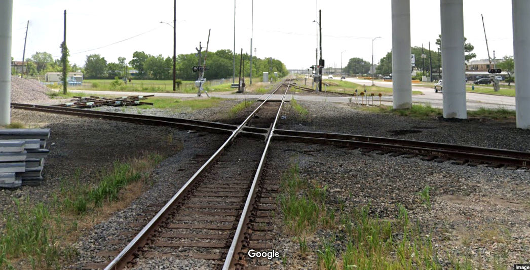
Above: Looking east at Pierce Junction in June, 2022, it appears that construction work
involving a new diamond is underway. Note the southeast quadrant connecting track
partly visible in the distance. Whether this connector has been sustained for
the entire history of Pierce Junction is undetermined, but it certainly existed
at the outset, providing the rail connection to Galveston and Harrisburg needed
by the plantations to the south.
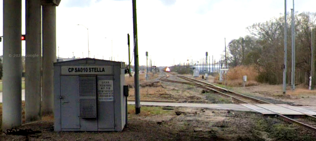
Below: Looking west from the west side of Pierce
Junction in March, 2021, a train approaches Control Point Stella which sits
beneath the overpass for Almeda Road. The street visible in the distance
crossing the two tracks is Knight Rd. which is approximately the location of the
switch at Stella for the GH&SA line to Chaney Junction. According to a 1912
GH&SA timetable, Stella was 0.2 miles west of the I&GN crossing at
Pierce Junction. (Google Street
Views)
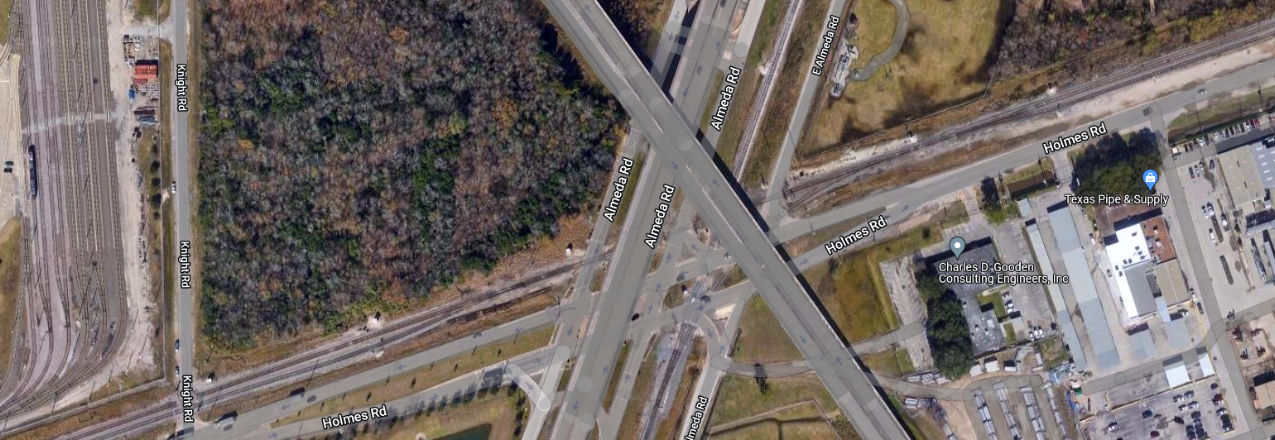
Above: This Google Maps satellite view of Pierce
Junction shows that Holmes Rd. is parallel to the former GH&SA line. The diamond
sits directly beneath the Belfort Ave. overpass which crosses over both Almeda
Rd. and Holmes Rd. The main artery of Almeda Rd. is also elevated over Holmes
Rd. and the tracks, but two frontage roads for Almeda Rd. cross at
grade, as does E. Almeda Rd. Since Holmes Rd. is not elevated, it crosses the
Columbia Tap at grade. The collection of
tracks at left is a maintenance and operations facility for Houston's METRO
Rail. The adjacent street, Knight Rd., marks the location of the switch at
Stella for the tracks to Chaney Junction. [If you use your imagination,
you can see a hint of a tree line that curves north, marking the right-of-way as
it approaches its alignment onto Almeda Rd.]
The timetable shows that at least by 1912 (and probably much earlier), the
route north from Stella was listed as the GH&SA main line and the
track through Pierce Junction to Harrisburg was considered a branch line. Below Left: the Columbia Tap
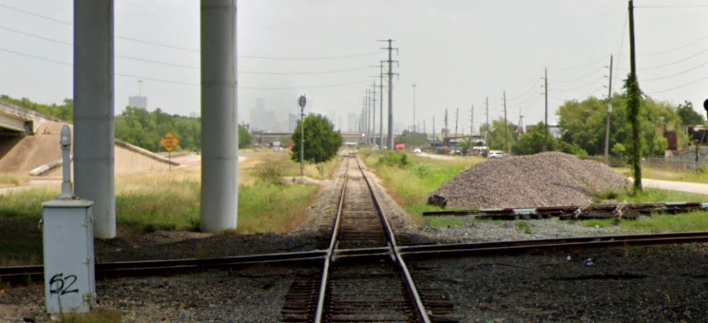
looking north from the diamond in June, 2022 (Google Street View)
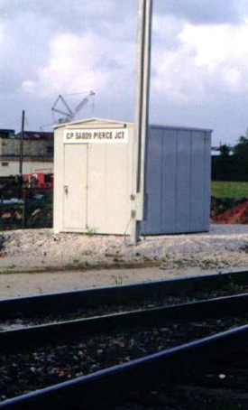
Below Right: This 2005 image
shows that UP had a control point named "Pierce Jct"; it no longer exists.
(Jim King photo)
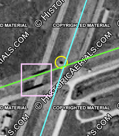 |
Left:
This 1953 aerial image ((c)historicaerials.com) shows a shadow being cast to the
north (yellow circle), presumably by the interlocker cabin adjacent to
the Pierce Junction diamond. The cabin was north of the SP
(GH&SA) tracks (green) and west of the MP (I&GN) tracks (blue).
Two bridges
casting shadows to the north (pink rectangle) show that in those days, both
Holmes Rd. and the SP tracks went over Almeda
Rd., a situation that is now reversed. Historic aerials show that the
Holmes Rd. bridge survived to at least 1973, and the SP bridge survived
until at least 1983. |