Texas Railroad History - Tower 118 (Belt Junction) and
Tower 119 (T&P Junction)
Two Towers on the Dallas Belt Line


Above Left:
This undated photo of Tower 118 at Belt Junction shows it to be a standard
Southern Pacific (SP) design, architecturally similar to many other SP towers in
Texas, particularly Tower 115. (Robbie Patterson photo, hat tip,
Mark St. Aubin) Above Right:
This photograph of Tower 119 at T&P Junction was taken by Myron Malone on
December 28, 1981. Records of the Railroad Commission of Texas indicate that it
was operated, at least in the early years, by Texas & Pacific (T&P) personnel.
This suggests that the tower was also designed and built under T&P supervision.
It doesn't particularly resemble an SP tower, but the photos of it date from
1981, so how it looked in 1926 and the unknown extent of any modifications over
the decades leave this an open question. The T&P was the only other
railroad at the junction and unfortunately, among all of the Texas towers for
which photos are extant, the handful known to have been operated by the T&P and
thus, potentially designed by them, do not exhibit any common architectural
themes that would shed light on the origin of Tower 119, e.g.
Towers 20, 28,
42, 55,
62 and 79. SP and the
T&P shared the tower's capital and recurring expenses, but the definition of how
those expenses were split has not been uncovered.
In the aftermath of the Great Flood of
1908 on the Trinity River through Dallas, government and business leaders
scrambled to develop a plan to mitigate devastation from the inevitable next
flood. The water level had reached 52 ft. above normal, resulting in
loss of lives and homes, a city-wide failure of electric power, drinking water and
communications links, and the destruction of numerous highway and railroad bridges. Renowned city planner
(and former Dallas resident) George Kessler was hired to create
a plan for Dallas' physical infrastructure to make the city more livable while
improving the city's flood preparedness. Among many elements of the Kessler Plan was the
establishment of a new Union Station at the
west end of downtown Dallas for the convenience of the traveling public.
Exercising authority under a new state law, the Railroad Commission of Texas
(RCT) issued an order in December, 1909 requiring the City of Dallas to
plan and build a union passenger station. This had been the subject of a
long-simmering dispute among Dallas' railroads, but RCT's order provided the
legal impetus to solve the problem. Kessler's work on a comprehensive plan for
Dallas had just begun, but he was able to provide his concept and guidance to
government, business and railroad officials for a new Dallas Union Station.
In addition to
building a new passenger station, Kessler wanted to improve pedestrian and
vehicle safety in the central business district by eliminating the main line
railroad crossings in downtown, either by grade separation or by establishing
alternate routes. The Dallas City Commission hired a consulting engineer, J. F.
Wallace of Chicago, to study the problem. As reported by
Railway Review on December 18, 1915,
Wallace recommended "...the construction of a belt line railroad around the
city with interchange and terminal facilities for the joint use of all lines
entering the city. Estimated cost of construction is $900,000 as compared with
an estimate of about $5,000,000 to elevate tracks now existing."
Moving forward with the belt line concept, the first need was to establish alternate
routes so the tracks through downtown could be relegated to secondary status. The
plan that evolved called for the main lines of the Texas & Pacific (T&P) Railway
and the Houston & Texas Central (H&TC) Railway, a Southern Pacific (SP)
subsidiary, to
be rerouted south and east of downtown on a new Dallas Belt Line to be
constructed by SP. For the T&P, this meant eventually removing their east/west tracks
on
Pacific Ave. that crossed the center of downtown. The T&P main line could not be
completely eliminated from the west end of downtown because its bridge over the Trinity River began
at the western terminus of Pacific Ave. For
SP, it meant abandoning the H&TC's tracks through the east end of
downtown. It would take decades to complete these track removals because both
railroads served businesses in and near downtown that could not simply be
abandoned.
Construction of the Dallas Belt Line began in 1919.
 |
Left:
Four years before the Belt Line construction began, this 1915 track
chart for Dallas (hat tip Ed Chambers) was created by the Missouri,
Kansas & Texas (MK&T, "Katy") Railroad. The interlocking tower
locations and major
tracks have been highlighted. Notably, the downtown crossing of the H&TC and
T&P main lines was not interlocked despite an order to do so issued by
RCT in 1902. The railroads likely prevailed in rescinding the
order due to the proximity of Union Depot ("Depot"), where trains on
both tracks frequently stopped anyway (as required by state law for
uncontrolled grade crossings of two railroads.) Despite the name or the presence of the Union Depot
Hotel across the SP tracks, it was not
a union passenger station since none of the other railroads used it. The
new Union Station would open at the far west end of downtown on
October 14, 1916 preceded by Towers 106 and 107 two weeks earlier, replacing Tower 57.
SP's tracks were in the east end of downtown, hence its passenger trains
would need to use the Katy to access Union Station, going north via
Tower 35 and south via the new Belt Line connection at Forest Ave. SP's line to Briggs was its
southeast route to
Beaumont, officially owned by a subsidiary, the Texas & New Orleans (T&NO)
Railroad.
The Gulf, Colorado & Santa Fe Railway main line between
Cleburne and Paris
crossed diagonally past the south side of the central business district.
A spur to the north was built to reach Santa Fe's passenger station
(Commerce at Murphy St.) and a warehouse
downtown. The main line's three crossings of other railroads were controlled by Tower 19 (Katy), Tower 10 (H&TC) and
Tower 22 (T&P); all had been commissioned before the end of 1903. |
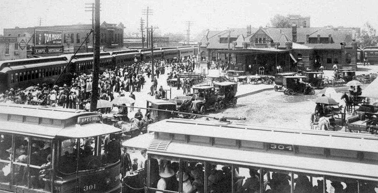
Below: The "Depot" on the map above may not have lived
up to its "Union Depot" name, but as this c.1908 northwest-facing photo shows,
it could be a busy place. The crowd in the plaza and the fully loaded streetcars
on Elm St. in the foreground suggest that a SP passenger train is making a stop.
A passenger car is also visible (at right) on the "depot lead" on the other side
of the station facing the T&P tracks which SP also used, for its Beaumont trains
via the T&NO line through Briggs. The T&P
did not use this station initially; its passenger depot was farther west on Pacific Ave.
at Lamar St. It appears that T&P moved its operations here at
some point, resulting in the name change to Union Depot. The Union Depot Hotel is the large building across the SP
tracks, although at the time of this photo, it was called the Conerty Hotel
under Charles Connerty's short-lived ownership. The hotel resumed its original
name when Conerty
sold it, perhaps to pay for legal assistance, having been charged in 1909 with
selling liquor on a Sunday. With the opening of the new Union Station facility
in 1916, the hotel's profitable business selling convenient accommodations to
railroad passengers was eliminated and it went into a lengthy decline. The
building nonetheless avoided the wrecking ball until 1968, but had been vacant for many
years. With passenger traffic gone, Union Depot remained in use as a freight
station through 1933 and then was razed in January, 1935. Google Street View
provides a ground level view in the same direction from approximately the same
location, but it's truly
hard to imagine. (DeGolyer Library collection, Southern Methodist
University)
The first phase of the Belt Line construction in
1919-20 was to build the bypass south of downtown. There were existing Katy
tracks that ran southeast from Union Station to Forest Ave. (about
0.6 miles southeast of Tower 19) where they turned south to cross the
Trinity River toward
Waxahachie. Under SP ownership, the Belt Line
construction laid 1.9 miles of new track southeast from the Katy main
line at
Forest Ave., staying on the north/east side of the river. These tracks connected with
the H&TC main line about four miles southeast of downtown. Where the
Belt Line crossed the H&TC, two
new control points were established: Metzger and Belt
Junction.
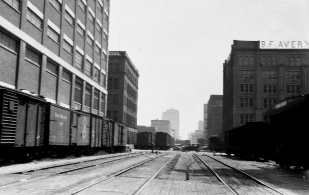
Above:
Although the T&P main line bypass south of downtown was in place by 1921, it would still take many
years to remove the tracks from Pacific Ave. as evidenced by these
photos (courtesy John W. Barriger III National Railroad Library) taken by
railroad executive John W. Barriger III in the mid 1930s. The views are down
Pacific Ave facing west (left,
from N. Houston St.) and east (right,
from N. Record St.). The west view shows the T&P bridge over the Trinity River
in the distance; Tower 106 sits to the left of the signal bridge. The east
view shows the B. F. Avery building on the right and a building at 301 N. Market
St. in the foreground on the left, both of which still stand.
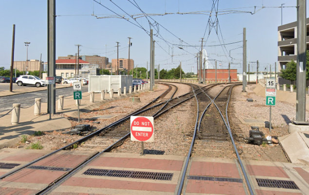
Below: The equivalent Google
Maps views from May, 2022 show how much has changed. Ironically, rails were put
back onto Pacific Ave. for the Dallas Area Rapid Transit (DART) light rail
system in the 1990s. Tower 106 now has a red roof, and the B. F. Avery building
has been painted white and acquired new lower story windows -- the arched upper
story windows remain intact.
From Belt Jct., the new construction continued
approximately three miles northeast to intersect the T&P main line at what
became known as T&P Junction. About 0.75 miles south of T&P Jct., the
Belt Line crossed SP's main line from Dallas to Beaumont at grade, a location
called Briggs. The track from Briggs into downtown would be abandoned
because it terminated into the T&P main line already planned for removal. In
1926, Belt Line construction resumed north from T&P Jct. and reconnected to SP's
main line about eight miles north of downtown, a location SP called
Gifford. Between T&P Jct. and Gifford, the Belt Line's crossings of
the Santa Fe and the Katy were grade separated.
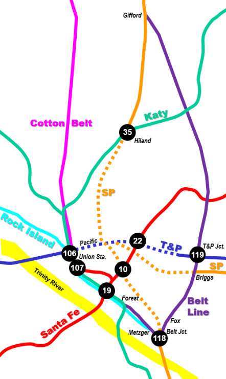 |
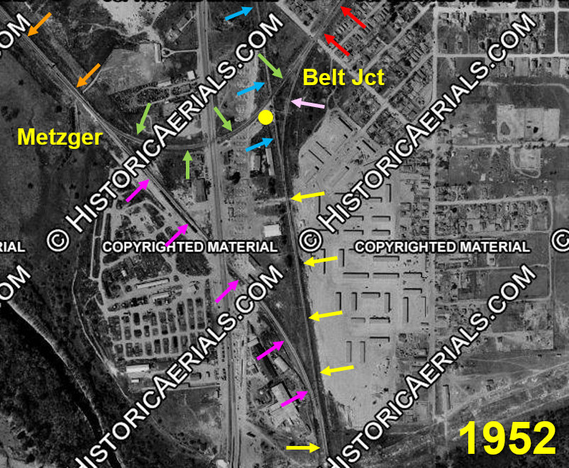
Left: area map depicting main tracks and
planned abandonments
Above: This
image ((c) historicaerials.com) shows the Belt Line (orange) toward the
Katy at Forest Ave. SP passenger trains used a connector (purple) on/off
the SP main line (yellow) while freight trains took a connector (pink)
on/off the Belt Line (red) to T&P Jct. and Gifford. Trains between
downtown and Briggs or T&P Jct. continued (green) across the old SP main
(blue) which appears still intact in this image; it was
gone by 1956. Tower 118 (yellow dot) opened in 1926. The visible north /
south roadway is S. Lamar Blvd. |
Noted Texas rail historian David Bernstein explains how operations
began on the
new Dallas Belt Line...
The first SP timetable to
include this line was Dallas Division No. 181, effective October 1, 1920. There
was no signal system nor interlockings in service on the Belt Line. The switches at Forest Avenue
were handled by a switch tender; the switches at Metzger, Belt Junction and
Briggs were handled by trainmen. The railroad crossings at grade with the
Denison Subdivision (H&TC main line) at Belt Junction and the Beaumont-Galveston
Division at Briggs were not interlocked. Effective with timetable No. 181,
Beaumont-Galveston Division passenger trains 147-148-155-156 began accessing
Union Station via the Belt Line. The only regular trains crossing the diamond at
Briggs were Beaumont-Galveston Division freight trains 165-166-167-168 which
began using the Belt Line in 1926.
Effective with issuance of Dallas Division Timetable No. 183 on July 31, 1921,
the T&P began using the Belt Line to T&P Junction. An interlocking office was
established at Metzger, 0.34 miles west of Belt Junction at the east end of
double track from Forest Avenue. The operator controlled four power switches. At
this time the switches at Forest Avenue, Briggs and T&P Junction were hand
operated and the crossings at Belt Junction and Briggs were not interlocked.
Train order offices were established at Metzger, Briggs and T&P Junction.
Regular trains between Belt Junction and T&P Junction consisted of four T&NO
Beaumont-Galveston Division passenger trains (via Briggs) and eight T&P
passenger trains (via T&P Junction). Freight trains and switch engines operated
as extra trains.
The 1922 Sanborn Fire Insurance map of Dallas shows two
parallel tracks between Metzger and Forest Ave. The north track is labeled "SP"
and the south track is labeled "CRI&G" (Chicago, Rock Island & Gulf), neither of
which appears on the next earlier map (1905). The SP tracks reflect the Belt
Line construction, and they end at Forest Ave. where they connect to the Katy.
The Rock Island tracks extend all the way to Union Station. Whether Rock
Island's tracks were laid as a component of the initial Belt Line construction
is undetermined, but the result was a double track between Union Station and
Metzger. It also gave Rock Island access to a growing industrial area south of
downtown which they had probably been prohibited from serving under their existing trackage
rights on the Katy between Dallas and Waxahachie.
The diamond at Briggs was
soon eliminated, replaced by connector tracks
in the southeast and southwest quadrants, with signals controlled by the Tower
119 operator. David Bernstein explains...
SP Dallas Division Timetable No. 196 issued
April 4, 1926, was the first with the entire Dallas Belt completed from Forest
Avenue to Gifford. Fox siding was now in service. At this time, regular trains
were four SP Beaumont Division passenger trains between Forest Avenue and
Briggs, eight T&P passenger trains between Forest Avenue and T&P
Junction, and two SP Dallas Division freight trains between Belt Junction and
Gifford. During 1926, automatic block signals were installed between Belt Jct.
and T&P Jct. and the two interlocking towers were constructed at a cost of
approximately $100,000. Tower 118 (Belt
Junction) was in service September 24, 1926, a 40-lever electric machine
controlling Metzger, Belt Junction, the crossing of the original H&TC mainline with
the Belt Line, and both ends of Fox siding. Tower 118 was established as a train
order office replacing Metzger. Technically, Belt Junction was south of Tower
118 at the bottom of the inverted triangle where the west leg (to Metzger/Forest
Avenue) and the east leg (to Briggs/T&P Junction) joined the original H&TC
main line.
Metzger no longer appeared in timetables beginning with No. 198 in November,
1926.
Tower 119 (T&P Junction) was in service May 18, 1926 with a 48-lever electric
machine controlling signals and switches at T&P Jct. and Briggs. The crossing at
Briggs was retired and the southeast connection to the Beaumont Division was
interlocked. The southwest connection to the former Beaumont Division main track
to Dallas was a hand operated switch with an absolute signal controlled by Tower
119. Tower 119 and Briggs continued as train order offices. In later years T&P
Junction was renamed MP (Missouri Pacific) Jct. and later UP (Union Pacific) Jct.
By November 1927, the Belt Line was
handling an average of 68 through train movements and 35 switch engine movements
daily. All T&P movements had been shifted off the original main line which was
partly retained as an industry lead. SP had moved all traffic from the
original H&TC mainline between Dallas and Gifford to the Belt Line except switch
engines. Passenger trains 19 and 20, the Central Express operating between
Houston and Denison, were operated over the Katy between Dallas Union Station
and Tower 35 (H&TC MP 268.5), then on the original
main line 4.5 miles to Gifford.
RCT's published
table of interlocking towers dated December 31,
1926 identifies Tower 118 as
"Dallas, Metzger
Junction" and Tower 119 as "East Dallas". It also lists the
railroads involved at Tower 118 as "H&TC -- Belt Line" whereas for Tower 119, it
lists "T&P -- H&TC -- Belt Line" (but there was no Belt Line railroad; the
notation was simply a geographic descriptor.) No other railroad being listed for
Tower 118 implies that the T&P did not participate in sharing the recurring
operating and maintenance costs. This is likely due to the fact that all of the
tracks at Belt Jct. were owned by SP -- the T&P was simply exercising trackage
rights granted as part of the Dallas Belt Line plan that the railroads
collectively negotiated. The T&P being listed first for Tower 119 indicates that
that T&P had the staffing responsibility, at least for operations and most
likely for maintenance. This would not, however, preclude joint staffing as the
railroads were free to negotiate their own arrangements (e.g. maintenance at
Briggs was likely SP's responsibility -- they were the only railroad there --
even though the signals and switches were controlled from Tower 119.) Beginning
with the table published December 31, 1927, Tower 119's location was changed to "Dallas", and this persisted
(along with Tower 118's
"Dallas, Metzger Jct." listing) through the final published table dated December
31, 1930.
The H&TC main line north of Belt Jct. was
relegated to spur status, leading to a substantial reduction in traffic at Tower 10.
It was closed as a manned facility in 1933 (but its interlocking plant remained in use, controlled by Tower 19.) As more of the planned track removals were
implemented, traffic reductions at Tower 22 and Tower 35 resulted in downgrades, closures
and conversions to automatic operation in later years. As freeway development
began to seek available rights-of-way, most of the remainder of the H&TC and T&P
tracks into and through downtown were finally removed in the 1950s.
It took decades to accomplish the
abandonments envisioned by the Dallas Belt Line plan, and there have been many
other modifications to the Dallas rail landscape since then. A major change occurred in the mid
1960s when the Cotton Belt right-of-way (ROW) was converted to host freeway
traffic, becoming the Dallas North Tollway. Then, in
the 1980s and 90s, two
complementary trends occurred that greatly affected the topology of Dallas' rail
network. Union Pacific (UP) acquired Missouri Pacific (MP), the Katy and SP
while Burlington Northern merged with Santa Fe creating BNSF. These
mergers and acquisitions occurred during the time that the DART light rail system was being
planned. DART needed rights-of-way
while UP and BNSF had excess rights-of-way due to various route alternatives
created by their acquisitions. DART was able to acquire various excess railroad
ROWs from UP and BNSF and use them for its new light rail system. For example,
UP made operational changes that deprecated the former SP
main line north from Dallas to Sherman and
Denison. DART built light rail on this ROW from
approximately Tower 35 north through Gifford to Plano.
Kansas City Southern (KCS)
also entered
the Dallas market from Greenville by purchasing
Santa Fe and SP (ex-Cotton Belt) trackage. The Belt Line / Santa Fe crossing
north of T&P Jct. was reworked into a single direct connection between the Belt
Line to the south and the Santa Fe tracks to the northeast (by then owned by
KCS.) The result was a route for KCS to reach
downtown
Dallas from Garland via this new Belt Line
connection. The Santa Fe ROW southwest of the crossing was abandoned and became
a recreational trail. The Belt Line north to Gifford was sold to DART, but it is
now a recreational trail
as DART never used it.
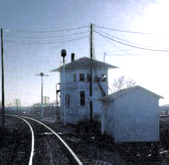
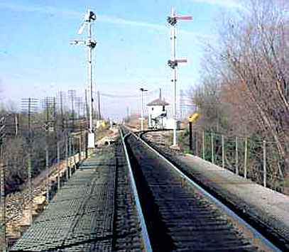

Above Left:
This photo of Tower 119 at T&P Jct. is the view that a westbound T&P locomotive
would have had when approaching the Belt Line tracks (behind the tower) to proceed
south to Belt
Jct. The tower was within the acute angle near the switch. This track is now the
main line; the original T&P main track that passed north of the tower was
removed, no longer crossing the Belt Line. Above Center: This photo was
taken standing on the Belt Line looking north toward T&P Jct. The track
departing to the right passes beside Tower 119 (see left image) and connects to the
original T&P main line. When this photo was taken, the Belt Line straight
ahead beyond the tower
continued to
Gifford and was seeing regular SP freight trains. Now this track continues north
to Garland operated by the switching railroad Dallas, Garland & Northeastern
(DG&NO). Above Right: This
view of the northwest corner of the tower was taken from the connector off the
Belt Line that led to the T&P tracks west of the junction. This
connector now becomes the west track from the junction since there is no longer
a crossing over the Belt Line. This trackage was
initially preserved to serve industry spurs and to provide access to the former
Age of Steam Railroad Museum at Fair Park. The museum is no longer at Fair Park,
and the tracks now end about a half mile west of where they reach the original
ROW. Tower 119
closed in 1989 followed by Tower 118 in 1994. (Myron Malone photos,
December 28, 1981)
Below Left and
Center: These two views of Tower 118 were taken by Myron Malone
on December 28, 1981. The east side of Tower 118 had a footbridge that allowed
operators to cross a creek to reach the tracks and hand paper orders up to
passing train crews. Below Right:
A westbound Southern Pacific (SP) SW1500 switcher takes the south connector at
Tower 118 toward SP's Miller Yard. The track in the foreground is the bypass
built by SP in 1920 as part of the Belt Line construction. Tower 118 did not
last long after it was closed. The abandoned building was damaged by
fire, presumably set by vandals, and it was
razed by Union Pacific c.1997.
(Myron Malone photo, May 15, 1982)


Summary of Key Dates (courtesy
David Bernstein)
1926 - Train order
office Briggs closed late in year (prior to November).
1930 - Crossing frog removed at Belt Junction (Dallas Belt Line crossing old
H&TC main track).
1943 - Centralized Traffic Control (CTC) was installed between Miller Yard
(south of Belt Jct.) and T&P Junction. Tower 118
controlled from Miller to Briggs, but not including Briggs. Tower 119 controlled T&P
Junction to Briggs, including Briggs. Tower 119 interlocking was extended to
control west end of T&P Orphans Home siding in 1943.
1989 - Tower 119 (MP Jct.) closed. UP and Tower 118 jointly controlled MP
Jct.; Tower 118 assumed control of CTC between Briggs and MP Jct.
1990 - Tower 118 (Belt Jct.) assumed control of Tower 15 (Hearne) and
Tower 72 (Corsicana).
1992 - UP assumed maintenance and operation between Forest Avenue and T&P
Jct. (SP retained ownership).
1994 - May 26th Tower 118 (Belt Jct.) operator positions were abolished.
SP Train Dispatchers in Houston assumed control of the Hearne and Corsicana
interlockings. UP Train Dispatcher in Omaha assumed control of CTC between
Forest Avenue and UP Jct. (formerly T&P Jct.) and between Miller and Belt
Junction. Fox siding was retired.
1996 - September
11th, UP and SP merger takes effect; UP subsequently consolidates all
subsidiary rail operations under the UP name; December 31st, the BNSF merger
takes effect


Above Left:
This bird's eye view of the site of Tower 118 c.2008 (Microsoft Virtual
Earth) faces generally west. The concrete pad for the
tower is still intact, located beside the "bypass" track that leads to Forest
Ave. and Union Station beyond the freeway. The bottom track is the main line
south toward Miller Yard (to the left.) The footbridge is gone, but the small ravine
it spanned is visible
adjacent to the track. Above
Right: In this north-facing bird's eye view of T&P Junction c.2008 (Microsoft
Virtual Earth), the
right lead becomes the UP main line to the east on the original T&P ROW. The center track is the Dallas
Belt Line heading north, originally to Gifford but now to KCS'
operations in Garland via the revised interchange at the former Santa Fe
crossing. The left hand track goes to the original T&P main line
ROW to turn west to reach industry tracks.
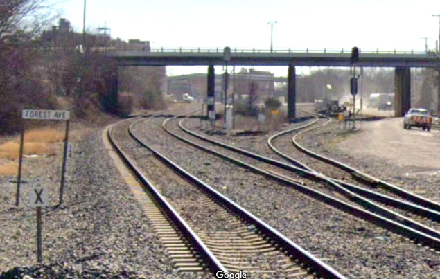
Below Left: In the Google Street View image looking southeast
from the Forest Ave. grade crossing, the double track at left goes to Belt Jct.,
essentially the SP and Rock Island tracks from c.1920. Dating from the 1880s, the former Katy
line branches off to the right, curves to the south, crosses the Trinity River
and proceeds to Waxahachie. Originally it continued southwest to
Hillsboro, but those tracks have been abandoned.
The tracks to Waxahachie are now used primarily by BNSF to reach the connection
to its main line to
Teague and Houston. BNSF is the current successor to the Trinity & Brazos Valley
(T&BV), which negotiated the Dallas - Waxahachie rights with the Katy c.1906 so
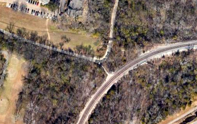
they would not need to build their new line from Teague all the way into Dallas. Below Right:
Where the north/south Belt Line formerly went over the east/west Santa Fe tracks
north of T&P Jct., this Google Earth satellite view shows how the crossing has
been reconfigured. The two rail lines now connect to form a route for KCS
(operated by DG&NO) from Garland to downtown via T&P Jct. and Belt Jct. The
other two legs now form a right angle turn on the
Santa Fe Trail. To the
left, the trail goes toward downtown as far as the site of Tower 22. To the
north, the trail runs beside White Rock Lake and becomes the
SoPac Trail extending up
the Belt Line ROW nearly to Gifford.