Texas Railroad History - Tower 182 - Lufkin (Prosser)
A Crossing of the Texas & New Orleans Railroad and the Angelina & Neches
River Railroad
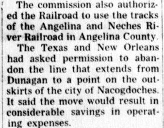
Above: Facing east along
the Angelina & Neches River (A&NR) Railroad, a derail is in use in the foreground,
adjacent to the chrome interlocker control post.
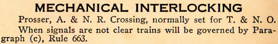
The cabinet adjacent to the crossing houses interlocker electronics. (Mark St. Aubin
photo, March 2018) The upper left inset
describing the interlocker is an image taken from an A&NR employee timetable effective October 30, 1983
(Richard Pennington collection).
Below Left: With "182" barely
visible on the attached nameplates, the Tower 182 electronics cabinet sits
parallel to the Union Pacific tracks. In a side view of the same cabinet (below
right), another cabinet adjacent to the "Prosser" sign
is
visible north of the diamond. (Mark St. Aubin photos, March 2018)


The Houston East & West Texas (HE&WT) Railroad line
through east Texas became known "the Rabbit", but how the nickname originated isn't
well-established. One source
claims it derived from passengers shooting rabbits from the train during stops
en route between Houston and Shreveport. A more
plausible explanation can be found in Robert S. Maxwell's book Whistle in the
Piney Woods (East Texas Historical Association and University of North Texas
Press, 1998) where Maxwell writes... "Because of its short, bobbing,
narrow-gauge cars, its up and down hill roadbed, its tendency to jump the track,
and, above all, its proclivity for "stopping behind every stump", the road was
promptly labeled 'The Rabbit'..." Although "the Rabbit" ran to
Shreveport, HE&WT's direct ownership ended at the
Louisiana border. The HE&WT charter had called for
Texarkana to be the northern endpoint, but the plan for a branch line to
Shreveport morphed into the main line, and no branch to Texarkana was ever
built. Construction commenced in Houston in 1877 and proceeded slowly
northeast. It took nearly a decade to reach the state line, the Sabine River, forty miles southwest of Shreveport. The bridge over the Sabine into
the town of Logansport, Louisiana opened on January 26, 1886.
Hard
economic times led to bankruptcy for the HE&WT, a common occurrence for
railroads of this era. After receivership and reorganization, the newly
reconstituted HE&WT converted all of its tracks to standard gauge on July 29,
1894, a massive one-day project (that somehow succeeded without cell phones.)
Standard gauge made the HE&WT substantially more valuable as it could
interchange cars directly with other railroads, providing better service to
Houston and Galveston for east Texas agriculture and lumber.
The dense woods and frequent rains of east Texas often made the dirt roads
impassable, hence passenger service to the two largest towns, Lufkin and
Nacogdoches, was critically important. Civilization at Nacogdoches dated back to
the founding of Spanish missions in the early 1700s, whereas Lufkin was founded
by the HE&WT in 1882, named for HE&WT President Paul Bremond's close friend,
Abraham Lufkin. Ten years
later, Lufkin became the county seat of Angelina County.
 |
The HE&WT's evolution into a
standard gauge line through east Texas caught the attention of Southern
Pacific (SP) Chairman C. P. Huntington, who sought to gain control of
the HE&WT to be part of a direct line he was contemplating from Houston to St. Louis.
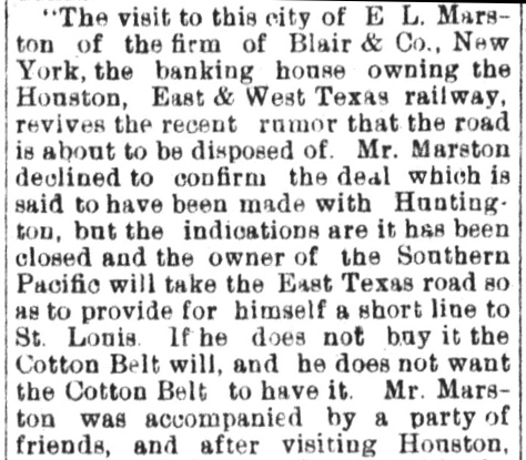
Left:
Although the dean of Texas railroad historians, S. G. Reed, asserts
October, 1899 as the timeframe of SP's takeover of the HE&WT, this
article from the El Paso International
Daily Times of March 1, 1900 suggests that the deal had only
been rumored, with the public announcement and closing of the sale
coming several months later. The same article (right)
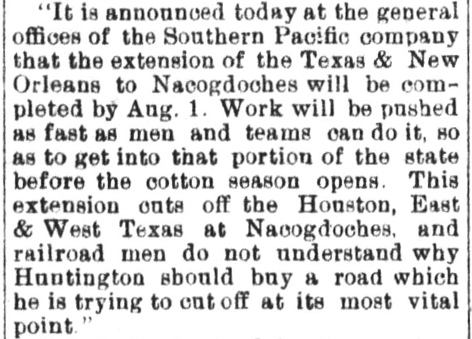
also announced SP's intention to extend its Texas & New Orleans (T&NO)
Railroad to Nacogdoches, which some "...railroad men do not
understand..." The T&NO extension was part of a deal in which the Texas
Legislature had authorized SP to acquire the Sabine & East Texas tracks
from Beaumont to Rockland and the Texas
Trunk Railroad from Dallas through
Kaufman to Cedar. The deal required the T&NO to
complete the gap between Cedar and Rockland, thereby creating a Beaumont
- Dallas main line. |
 |
As with its other Texas railroads, SP allowed the HE&WT
to continue operating under its own name. This arrangement continued until 1927
when the HE&WT was leased to the Texas & New Orleans (T&NO) Railroad.
Once it was merged fully into the T&NO in 1934, the HE&WT became extinct...but "the Rabbit"
hopped on, as the T&NO's Lufkin and Shreveport Subdivisions.
Among numerous east Texas lumber
companies was one
founded in 1890 by Joseph Kurth, Sr., who had purchased a sawmill two years
earlier from Charles Kelty. The sawmill site on the northwest outskirts of Lufkin became known as the
community of Keltys, and it became
the headquarters for Kurth's Angelina County Lumber Co. Kurth's company followed
the common practice of building narrow gauge tram lines into the
forest lands where it had timber rights; approximately sixteen miles of rail had been
laid
by 1893. Like many other east Texas lumber companies, Kurth eventually decided to organize
a portion of the tram lines as a separate railroad company owned by himself and a few
of his lumber
company executives. Thus, in 1900, the
Angelina & Neches River (A&NR) Railroad was chartered as a common
carrier railroad to take over the main line
of the tram
operation.
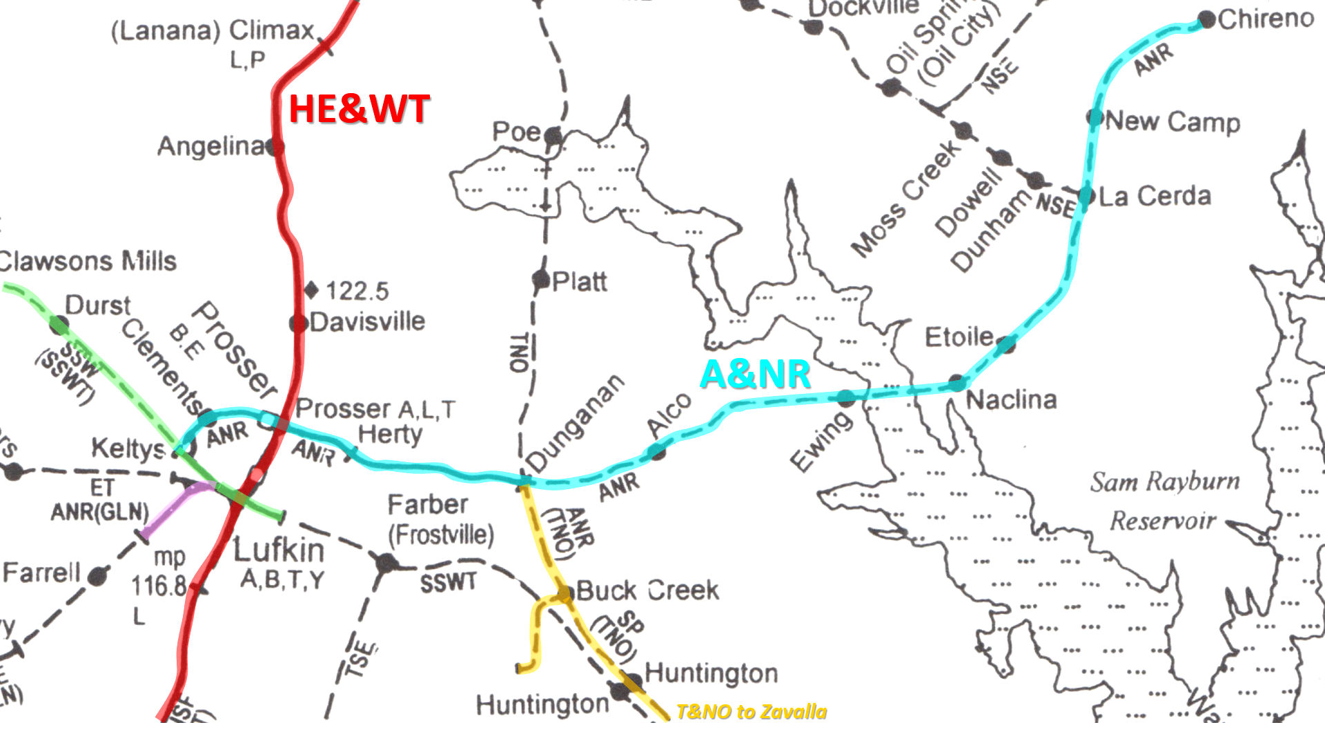
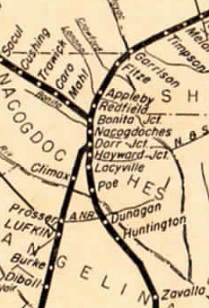
Above: This rail
map ((c) 2001, Mike Walker - SPV) has been annotated
to highlight the main route of the A&NR (light
blue) and the track segments that the A&NR began operating as other rail
lines were abandoned, sold or had trackage rights granted. These include the St. Louis Southwestern (SSW) commonly
known as the "Cotton Belt" (green); parts of a T&NO main line between
Beaumont and Nacogdoches (orange) that crossed the A&NR at Dunagan (misspelled
as "Dunganan"); and the
Texas Southeastern (TSE) Railroad (pink) on which the Groveton, Lufkin & Northern
(GLN) had operated into Lufkin using trackage rights until 1932. The TSE was
based at Diboll on the HE&WT (red) just off the map
south of Lufkin. The A&NR crossing of the HE&WT at Prosser, two miles north of downtown Lufkin,
became interlocked as Tower 182 in 1936. By that time, HE&WT's merger into the T&NO
had occurred, hence Tower 182 was considered to be a T&NO/A&NR interlocker.
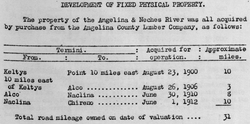 |
Left:
This item appeared in a Valuation Report for the A&NR released by the
Interstate Commerce Commission (ICC) in 1919 showing that all of the
tracks owned by the A&NR had been built originally by the Angelina
County Lumber Co. When the A&NR was incorporated on August 23, 1900, the
first ten miles of the "main line" of the existing tram were conveyed by
the lumber company. After that, tracks were built by the lumber company
and sold soon thereafter to the A&NR. It was less expensive for the
lumber company to do the construction because they could supply for
themselves the lumber needed for bridges, structures, signposts, etc.
This simplified the accounting that would otherwise be required if the
A&NR had to "buy" these items from the lumber company and hire lumber
company work crews to lay the tracks. Also, the lumber company built
temporary spurs into the forest so that raw logs could be moved to the
mill, but these spurs were not sold to the A&NR. Thus, work crews that
were extending the main line tracks for the lumber company could be
redirected to build forest spurs whenever necessary. Overall, having the
A&NR buy rail lines built by the lumber company was the most expeditious
way to expand A&NR trackage. |
Charles Zlatkovich's book, Texas Railroads: A Record
of Construction and Abandonment (University of Texas, 1981), compiled
construction records from the archives of the Railroad Commission of Texas
(RCT). It lists the Cotton Belt line into Lufkin as having been originally built
by the Kansas & Gulf Short Line Railroad in 1885. This was a 43-mile extension
south from Rusk that ultimately led back to Tyler where the Cotton Belt was
based. In 1903, the Cotton Belt acquired the tracks of the Texas & Louisiana
Railroad that had been completed from Lufkin east to Montery in 1902. This line was
later extended deeper into the east Texas forest to White City. As the timber
along this line was cut out, the segment from Prestridge (near Huntington) to
White City was abandoned in 1933, and the remaining tracks into Lufkin were
abandoned in 1939.
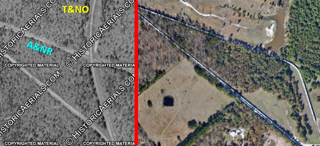
The first
A&NR record in Zlatkovich's book is dated 1911, a 19.89 mile segment from Keltys to "Nadina". The endpoint was
actually Naclina,
derived from the community's location very close to the Angelina River which is
the county line separating
Nacogdoches County and Angelina
County. The error undoubtedly stems from someone mistaking the letters cl for
the letter d in transcribing handwritten information (and not simply a
recent mistake; it appears in a document issued by the state of Minnesota in
1913 summarizing all of the rail lines in the U.S.)
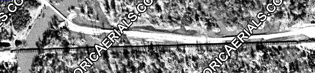 |
Left:
Naclina was the founded on the first reliably dry land on the east bank
of the Angelina River. Although the river's normal channel was not
particularly wide, the vicinity of the A&NR crossing, like much of the
upper reaches of the Angelina River, was prone to flooding due to
numerous creeks in the watershed and frequent heavy rains in east Texas.
To stay above the expected flood level required the A&NR to construct
the 2,000 ft. wooden trestle visible in this 1946 aerial image. ((c)
historicaerials.com) Today, this entire image would show nothing but the
waters of Sam Rayburn Reservoir surrounding a Texas Highway 103 bridge
built on the south side of the former A&NR right-of-way. |
The RCT record denotes construction of nearly
twenty miles, but the first ten miles to just beyond Dunagan that existed when the A&NR was formed in 1900
had never been reported to RCT nor had the additional three miles built to Alco
in 1906. Dunagan (a tiny settlement nearby) was the name chosen by T&NO
in 1901 to identify its new crossing of the A&NR. This was very close to the
original end of track for the A&NR known as McCoy, but Dunagan
became the mutually accepted name. As of 1942,
T&NO was operating a mixed train daily in each direction through Dunagan with
stops at 11:45 pm (northbound, but officially westward toward Dallas) and 4:25 am (southbound,
but officially eastward toward
Beaumont.) The T&NO had a siding at Dunagan that held 36 cars, and there
was a crew telephone at the station.
The impetus for incorporating the
A&NR was the opportunity to increase revenue by operating as a tap line. A tap line
was simply a chartered and incorporated common carrier railroad owned
by a lumber company (or its closely related interests, e.g. management
investors.) Tap lines moved raw logs inbound to the mill and moved
outbound
lumber products from the mill to
interchanges with trunk line railroads. Tap lines were also
allowed to serve the transportation needs of the general population and other industries along their
rail lines. Sawmill companies in Texas and
elsewhere were incentivized to convert their private logging trams to tap lines
because when common carrier
railroads exchanged traffic for interstate destinations, the revenue for the
entire shipment was shared. Thus, identical cars of identical lumber products
transferred to a trunk line for interstate shipments to different
customers would produce varying revenue to the tap line depending on
the division rate negotiated with the trunk line for each of
the final destinations. As common carrier railroads,
tap lines accepted two significant legal obligations: they had to offer
transportation services to the public without discrimination, and they had to set public
tariffs and charge fees for their services.
While it seems obvious that tap
lines would charge fees for transportation services, lumber companies
weren't accustomed to paying their tram lines to haul logs to the mill --
hauling logs was just another of the many plant activities that comprised the
mill's operations. As common carriers, tap lines had to charge
the mill to haul its logs since failing to do so would allow other nearby sawmills
to request the same service at the same tariff -- free. Offering transportation services with public tariffs and without
discrimination was an important legal obligation of common carriers, one
they did not always meet. Hence, the ICC began a
comprehensive investigation of tap lines in the early 1900s.
The
A&NR was called to testify before the ICC at a hearing held in New Orleans on
December 15, 1910. The ICC probe sought to identify railroads across the south
and west that were not legitimate tap lines due to violations of common carrier
obligations. The so called "Tap Line Cases" resulted in lengthy and complex
litigation that was ultimately settled by the U.S. Supreme Court. The ICC had
essentially disclaimed common carrier status for any tap line that was primarily
owned by a lumber company, regardless of evidence that it was fulfilling its
common carrier duties. The
courts rejected the ICC's position and remanded the cases for reconsideration
under a different legal interpretation. When the litigation finally faded out,
many tap lines had improved compliance with their obligations, but the ICC rulings were largely
rejected in the courts. As Ernest M. Teagarden described it in
The History of Federal Regulation of Railroad Joint
Rate Divisions (Bowling Green State University, Ohio, June, 1955)..."In the final analysis,
about all the Commission had accomplished toward a solution of the tap
line problem was to have its power defined by the Supreme Court. Commission
policy had been shifted from a policy of preventing proprietary divisions to one
of regulating them."
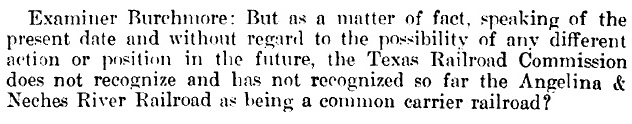
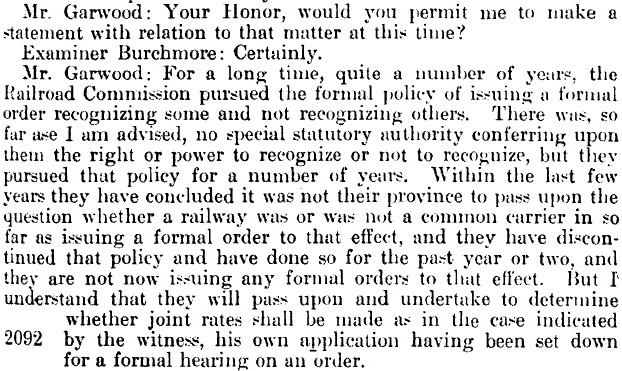
Below: The ICC hearing was conducted by Examiner
Burchmore and Administrative Judge Cowan. Appearing as the main witness for the
A&NR was Eli Wiener, its Secretary and Treasurer. In this passage, an
unidentified witness, Mr. Garwood, also appears (from his testimony, perhaps he
was an attorney representing RCT.) The witnesses discuss the difficulty of
getting RCT to recognize common carrier status. RCT had no jurisdiction over
interstate tariffs, but they were empowered to set rates for all intrastate
shipments. The complicated wording in the final sentence below explains that
RCT had already scheduled a hearing to determine whether the A&NR would be
allowed to establish joint rates for intrastate traffic.
The ICC hearing
transcript sheds significant
light on how the A&NR expanded and operated:
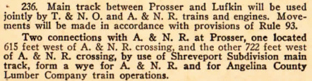
-
"The stockholders of the Angelina County Lumber
Company own the stock of the Angelina & Neches River Railroad in
substantially the same proportion, about 95% of the stockholders of the
lumber company own about 98% of the stock of the railroad company."
-
The A&NR "...is incorporated as a common
carrier railroad...and has held itself out in that capacity to the public
from the beginning..."
-
The Angelina County Lumber Company's only mill was
at Keltys. The Cotton Belt had connections into the mill such that it could
receive some types of lumber products for shipment "...without actually
moving over the rails of the Angelina & Neches River Railroad."
-
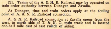
"...the present [December, 1910] terminus of
the railroad is Naclina, which is in Nacogdoches County, 19.89 miles from
Keltys." The 19.89 miles was the entire main line of the
A&NR, but the A&NR
also had 2.43 miles of sidings.
-
"There are logging lines at Naclina...owned
by...the Angelina County Lumber Company." Like all tap lines, the
A&NR had hauled raw logs to the Keltys mill for a fee.
By 1910, the lumber company and the A&NR had changed the process so that "...logs...cut up in the woods are
loaded on logging cars belonging to the lumber company..." The logging
cars "...are hauled by the lumber company's engines first to the
connection with the railroad, and there another lumber company engine
operated by the lumber company's employees brings those log cars into Keltys."
For the trackage rights to use the A&NR line to Keltys, the lumber company
paid the A&NR "...50 cents per thousand feet log scale for the logs
handled over the road."
-
The A&NR intersected with three trunk lines: the
Cotton Belt at Keltys, the HE&WT at Prosser and the T&NO at Dunagan. The
T&NO and HE&WT were both SP properties, but the A&NR did not exchange
traffic with the T&NO. "The T&NO and the HE&WT interests are practically
identical, and for that reason, we have never interchanged with them."
-
For most of 1910, the volume of finished lumber
shipped out via the HE&WT at Prosser was "...fairly heavy, and for the
last month or two the Southern Pacific system seems to have been short of
empty cars and the tonnage has not been so heavy..."
-
Because the A&NR was chartered as a common carrier
when it was incorporated, it began receiving negotiated divisions on interstate traffic via the Cotton
Belt in 1900. It did not receive divisions with the HE&WT at that time.
This changed several years later, and by 1910, the A&NR had "...joint rates on lumber with both the
Cotton Belt and ... the Houston East & West Texas ...to points all over the
country."
-
The A&NR acquired a passenger car from SP that "...is used in daily operation of a mixed
passenger and freight train." Passenger service commenced November 7,
1910. The daily mixed train "...leaves Keltys in the
morning about fifteen minutes after the arrival of the Cotton Belt train and
returns about ten minutes before the arrival of the Cotton Belt train going
in the opposite direction. ... It does not connect with the Houston East &
West Texas trains..."
-
The A&NR has "...requested the Houston East &
West Texas to give ... trackage privileges into the town of Lufkin..."
for passenger service purposes; the request was later granted. The HE&WT station
for Lufkin was about two miles south of Prosser.
-
"We have about ten miles that we expect to
build in the next ten or twelve months...[to] the town of Chireno and give a
market outlet for five thousand bales of cotton. ... The charter has been
amended to include that extension." The longer term objective was to
build 28 miles "...to the Santa Fe, at San Augustine."
...but the
extension beyond Chireno to San Augustine was never built.
The A&NR had been chartered as a common carrier
railroad. Thus, for interstate traffic, they could negotiate divisions under ICC
rules. In 1905, A&NR decided to seek a formal
declaration of common carrier status from RCT so they could propose divisions on intrastate traffic.
Such declaration from RCT would also give A&NR the
unquestioned right to carry goods and people for fares. Unfortunately, A&NR
submitted its application to RCT during the time the Commission had begun to question whether it had the
legal authority to make declarations of common carrier status; no law
explicitly said they could. Railroads with charters that asserted common carrier
status presumably possessed the legal authority to provide general
transportation services since charters were state laws. But intrastate fares
were regulated by RCT, and it held the exclusive power to authorize intrastate
joint rates, something it would not do for a railroad that it had not recognized
as a common carrier. RCT's sudden unwillingness to make
that declaration created a murky legal limbo. Carrying goods and people for
fares was not authorized for tram operations; it was strictly a common carrier railroad
function. Despite complying with RCT's general tariff regulations, railroads that did not
have a common carrier blessing from RCT risked potential legal action for
accepting fares for moving people and goods, particularly if their charters
didn't explicitly assert common carrier status.
Austin Statesman, October 25, 1905
El Paso Morning Times,
February 18, 1911 |
 |
Left &
Below:
Galveston Tribune, March 2, 1911
Right Top:
San Antonio Express, March 26, 1911
Right Bottom:
Houston Post, April 19, 1911 |
 |
Above: As early as 1905, the A&NR was
planning a request to RCT for a common
carrier status declaration, primarily to gain the right to seek divisions on revenue from outbound products
shipped intrastate from the mill at Keltys. No
evidence has surfaced to indicate that RCT ever acted on the
request; it certainly wasn't granted. The subject
returned in 1911 as the A&NR was nearing completion of an extension into the
community of Chireno, eleven miles beyond Naclina. In the aftermath of the ICC
hearing, the A&NR was concerned about carrying passengers and goods for the
townspeople of Chireno without RCT approval. RCT denied the request, but then agreed to reconsider
after a delegation from Chireno made a plea directly to the three Commissioners in
early March. Although the March news item from the
Galveston
Tribune stated that RCT's denial of the request would be reversed, the
outcome remained in doubt until mid April when it became clear that Commissioner Wortham had changed his position and favored granting common carrier status to
the A&NR. RCT issued
Circular No.
3770 on May 1, 1911 to approve the request.
RCT's order required the A&NR
to commence services at Chireno by January 1, 1912. That date was chosen because
the A&NR had signed a contract with Chireno to provide service to the town
by that date
in exchange for various considerations,
e.g. a free right-of-way and depot grounds in Chireno. The A&NR's 1919 ICC
Valuation Report states that donations of $10,100 were received "...from the
citizens of Chireno and Lufkin, Tex., as an aid in constructing its road into
Chireno, Tex." The extension to Chireno also resulted in a connection with the
Nacogdoches & Southeastern (NSE), a tap line railroad, at La Cerda. The nature of
the NSE exchange at La Cerda is undetermined, but aerial imagery from 1956
shows there was a connecting track in the northwest quadrant of the diamond. The NSE was abandoned in 1954, and the A&NR line from Dunagan to
Chireno was abandoned in 1963.
The location where the Angelina County
Lumber Co. had built its tram line across
the HE&WT c.1893, about three miles east of Keltys, came to be
known as Prosser, but the origin of the name is undetermined. Lumber trams
building across Class 1 railroads was not uncommon in east Texas, and it
took many years for RCT to enforce safety requirements on uncontrolled
tram crossings. Railroads occasionally ignored the state law requiring all trains
to stop at all uncontrolled crossings, perhaps because
they considered "tram crossings" to be different from "railroad crossings". RCT
began regulating railroad grade crossings in 1901, and the first
interlockers were commissioned for operation in 1902. The first tap line
crossing to be interlocked was Tower 110 in 1917,
and the first tram crossing to be interlocked was Tower 111
in 1919.
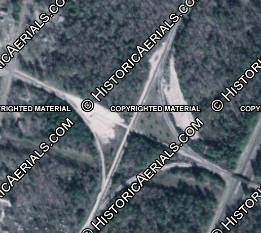 |
Left: This 1982
aerial image ((c) historicaerials.com) of Prosser shows
the A&NR angling slightly more than due east/west and SP's tracks
similarly angled north/south. There are connections in three quadrants,
two of which remain intact; the northeast connector was taken out in the mid 1990s.
Imagery from 1947 shows northwest and southwest connectors only, and
1955 imagery adds a southeast connector.
The crossing at Prosser was not interlocked until 1936 when
Tower 182 was commissioned by RCT. SP records obtained by Carl Codney list Tower
182 as a "ground lever" plant, a mechanical interlocker that required
rotating trackside levers near the diamond to effect derail and semaphore
signal changes permitting A&NR trains to cross.
A table in the January 2, 1937 edition of
Railway Age lists the Prosser
interlocking as a 3-lever mechanical plant built by Union Switch &
Signal Co. The plant was later upgraded to use electronic relays, but it
was (and apparently still is) operated by A&NR
train crews when they wish to cross. While Prosser has been swallowed by the growth of Lufkin, and Union
Pacific (UP) has succeeded SP, the A&NR
continues to operate over the remnants of the original line from Keltys through
Tower 182 east to Dunagan. It also operates on 3.5 miles of UP tracks into
Lufkin, and uses remnant tracks of the Cotton Belt from Keltys, where
the mill has long been closed. A paper mill at Herty became a
major customer for the A&NR in the 1940s, producing newsprint and other
products. The mill was closed at the end of 2003, but its multiple
siding tracks appear to remain in use by the A&NR for railcar storage.
The A&NR's business is now based on serving a variety of industrial
facilities across Lufkin and providing railcar storage for other
railroads.
Below:
excerpt from a 1949 T&NO Employee Timetable (ETT)
 |
Six miles east of Prosser, the T&NO/A&NR crossing at Dunagan
does not appear in RCT's interlocker numbering system. There is, however, a clue
that it was controlled to some extent by the railroads. A T&NO ETT dated March
8, 1942 specifies that "F-1 and MK-5 class engines must not use the
following tracks:", followed by a list that includes "Dunagan -- Track leading to
A. & N. R. R. R. beyond derail." The existence of a derail on the
A&NR track at Dunagan
suggests that there was some kind of manual control, presumably designed to
restrict A&NR movements across the diamond so that T&NO trains were able to pass through Dunagan without stopping. Whether it
qualified as an interlocker or was simply manually operated signals and derails is undetermined,
but no evidence of RCT oversight of the Dunagan crossing has surfaced. There is
one documented instance of railroads controlling a tram crossing "on their own", without RCT oversight; see
Cruse.
 |
Left:
This map snippet taken from a June, 1954 T&NO ETT
shows that the two T&NO lines that crossed the A&NR at Prosser and Dunagan, respectively, combined into a single track through Nacogdoches
and then split north of town. The T&NO line through Dunagan was part
of a route between Beaumont and Dallas that had been completed in 1903.
Nacogdoches city leaders opposed creating a separate right-of-way for
the T&NO; the town had 2,000 residents and the downtown area was already
well-developed. They favored having the T&NO share the existing HE&WT
tracks since both railroads were SP properties. T&NO may have
obtained a right-of-way and they may have laid some track, but the
decision was made early on to share the tracks between Dorr Junction
(south) and Bonita Junction (north.) The
3.58-mile track segment between the two junctions is listed in the 1904 edition of Poor's Manual of
Railroads as "jointly operated".
Below:
The ETT provided rules governing A&NR movements at Prosser and
between Prosser and the Lufkin station. Note that the Angelina County
Lumber Co. was still hauling timber cars through Prosser using A&NR
trackage rights, and had the right to use the T&NO tracks when necessary
for wye purposes. The A&NR had trackage rights on the T&NO between Dunagan and Zavalla (lower right corner of the map), apparently to serve
a business at Zavalla at which the A&NR had built additional tracks.
 |
T&NO's
line between Dunagan and Nacogdoches (Dorr Jct.) had been difficult to maintain from the
outset due to its path through swampy lowlands where several creeks
flowed into the Angelina River. The route required multiple trestles,
and it was subject to frequent flooding and numerous bridge repairs.
Right: The
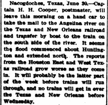
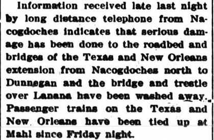
Alpine Avalanche dated July 4, 1902 reported on a major
Angelina River flood; this was perhaps only a year after the T&NO had
built its line through the river's bottomlands. Note that Lanana was a
bayou near Dorr Jct.; the HE&WT tracks crossed Bayou Lanana between
Nacogdoches and the river near Climax. Also, Dunagan was
south of Nacogdoches, not north.
While the
difficulty in maintaining this track segment may have motivated T&NO to consider a
permanent reroute via Prosser long before 1957, the die was cast when work began
on the McGee Bend Reservoir in 1956 (re-dedicated as Sam Rayburn Reservoir in
1965.) The substantial
investment required to rebuild the T&NO's Angelina River crossing to rise above
the flood control pool elevation could not be justified. |
 |
|
Above Left: In late
January, 1956, the T&NO asked the ICC to approve abandoning the tracks between
Dunagan and Nacogdoches. It also requested permission to "acquire" the A&NR's
tracks between Dunagan and Prosser. (Sulphur
Springs Daily News-Telegram, February 1, 1956)
Above Right: The ICC granted
permission to the T&NO on April 21, 1957, but trackage rights, not outright
acquisition, was authorized for T&NO's use of the A&NR line between Dunagan and
Prosser. (Ennis Daily News, April 22,
1957)
T&NO trains from Beaumont
began turning west at Dunagan on the A&NR to Prosser where they turned
north to continue to Bonita Junction. A northeast quadrant connector at
Prosser was built to support these movements. SP and A&NR agreed that SP
would handle dispatching duties for the tracks between Dunagan and
Prosser.
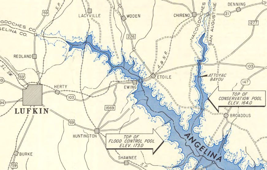
Right: This March,
2022 Google Maps simulated 3-D view of the former T&NO line looks south
across the Angelina River swamp from the north bank near Poe. At least
four small outcroppings are visible where tracks briefly transitioned
between trestles. The portion of the right-of-way at the bottom of the
image is now Nacogdoches County Road 539, which ends at a "tram boat
ramp" for river access.
Below:
This image is taken from a map produced by the Army Corps of
Engineers (courtesy, The History Center, Diboll) detailing the McBee
Bend Reservoir project. The T&NO's Angelina River crossing was about 4.5
miles south of Lacyville and 6.5 miles north of Dunagan (not marked.)
When this map was made in 1960, the T&NO line was already abandoned.
 |
 |
 |
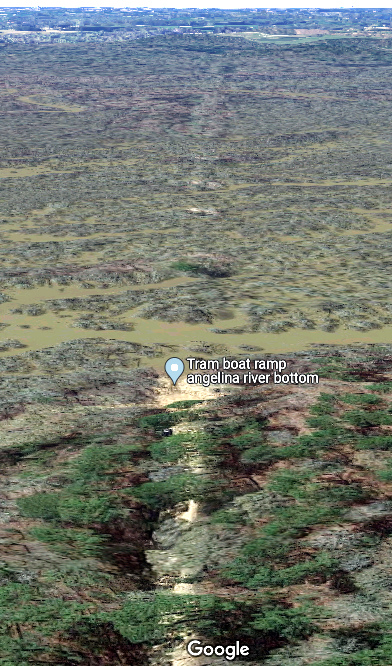
Left:
Pilings from the T&NO trestle remain in the Angelina River at the "tram
boat ramp", presumably where Postmaster Cooper caught the boat to cross
the river in 1902. (Google Maps photo by "Grandma Ghee")
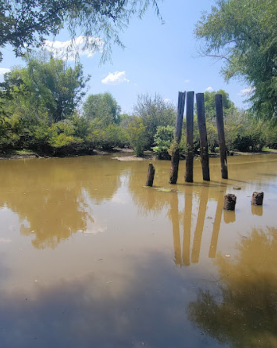
Above:
Approximately three miles of the T&NO right-of-way north of the former
Angelina River crossing has been repurposed as Nacogdoches County Road
539. Considering all of the roadways near Lufkin and Nacogdoches that
are not covered, it is surprising that Google Street View has imagery
for almost the entire distance to the boat ramp.
Drive it yourself going south from the FM 538 intersection, but be
careful -- it's a
dead end. Locals assume all such east Texas railroad rights-of-way
were logging trams, but this one never was. |
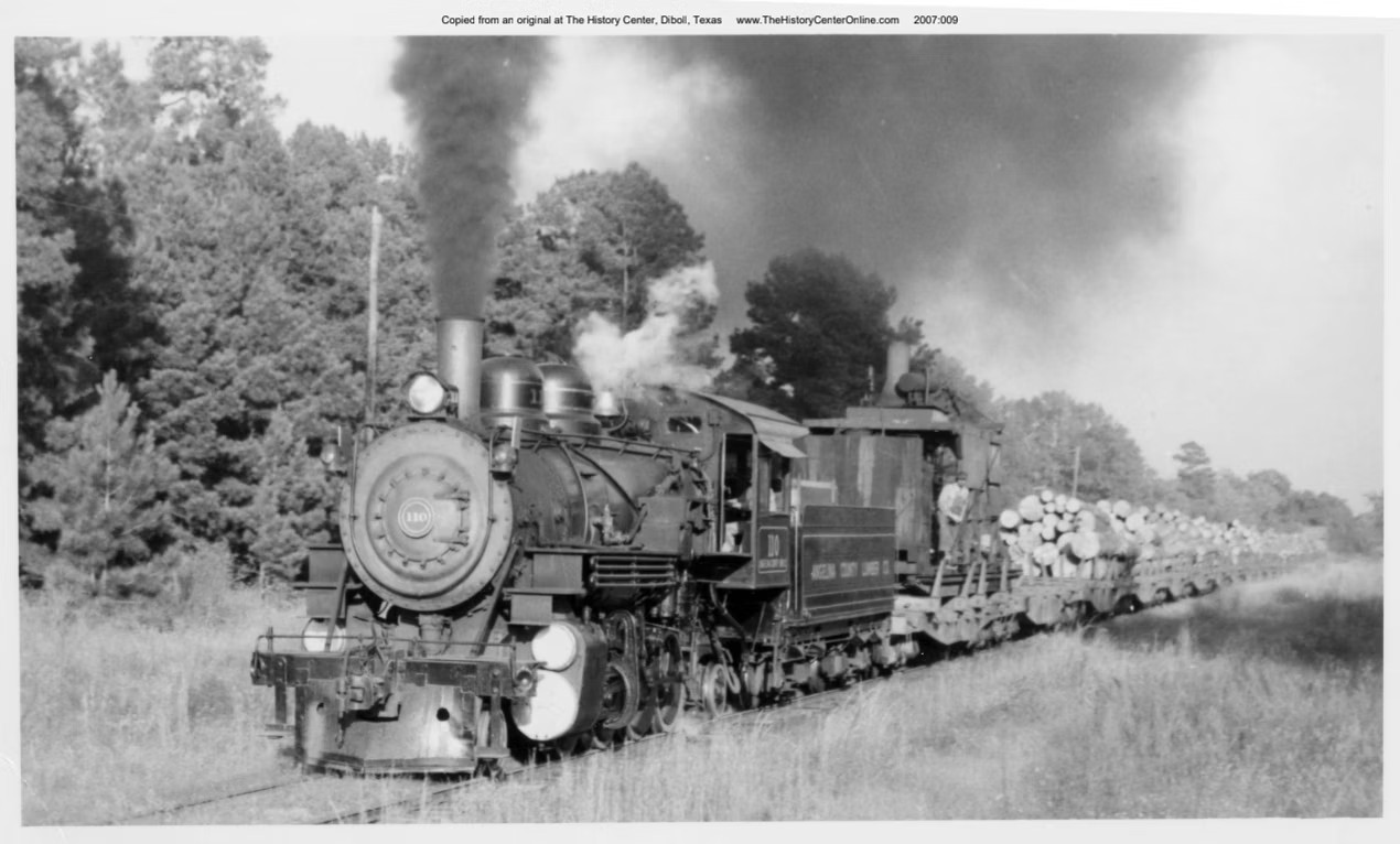
Above: In 1957, the Angelina
County Lumber Co. was still hauling logs to Keltys using A&NR trackage rights.
Here, #110 led by Engineer Jay Morrison pulls a load of logs between New Camp
and Dunagan. (A. E. Brown photo, collection of The History Center, Diboll,
Texas) Click the image to hear this engine with Jay Morrison at the controls as
it pulls a heavy log train near Keltys in 1959. (from A Symphony in Steam, by
L.J. Carlson and H.K. Vollrath, 1959, courtesy The History Center.)
On May 5, 1982, the Cotton Belt announced "...its
intention to sell the portion of its Lufkin Branch that extends approximately
from Rusk to Keltys to the Angelina and Neches River Railroad." (Alto
Herald, May 20, 1982.) The A&NR
decided not to proceed with the entire purchase, instead acquiring 6.6 miles of track
from near downtown Lufkin through Keltys to Clawson. The A&NR
officially abandoned the 4-mile segment from Keltys to Clawson in 1989. It no
longer provides services on this track but the track remains intact for railcar storage purposes. The
end of track at Clawson is just shy of its former grade crossing of Farm Road 2021
(at 31 24 01N, 94 47 46W); Google Street View shows railcars parked there as of
August, 2022. In the other direction from Keltys, tracks remain in use by A&NR as far as
the Bakelite Chemical facility a mile east of downtown Lufkin.
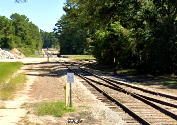
Above Left: Looking northwest at the Nile St. grade
crossing, this view faces the former Keltys sawmill site. The track at left is
the former Cotton Belt to Clawson, now used for railcar storage. The A&NR track
curving to the right was built c.1981 to connect the main line (which
intersected the Cotton Belt north of the sawmill) with the Cotton Belt tracks to
the southeast toward downtown. This facilitated A&NR serving businesses along
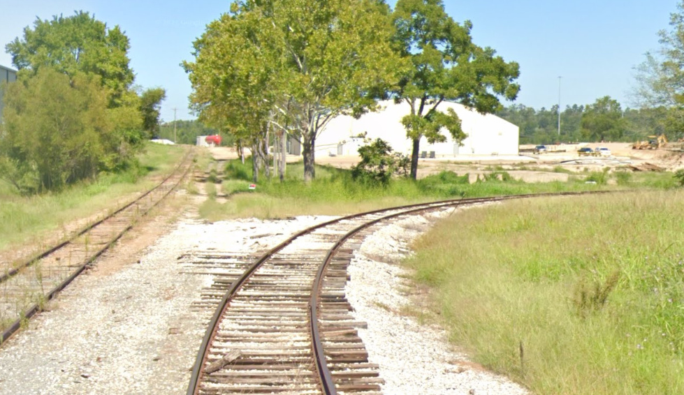
those tracks into central Lufkin. Above Right: This view
is east along the A&NR main track from the Spence St. grade crossing. The
Prosser diamond is in the distance, adjacent to the silver electronics cabinet.
(both images, Google Street View, 2022)
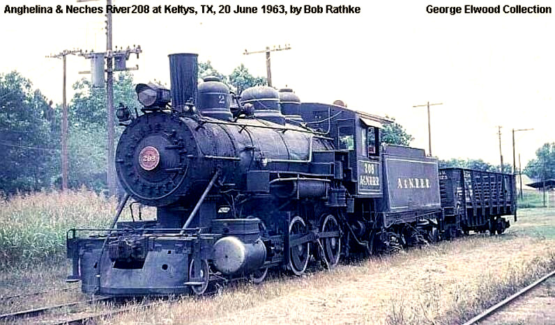 |
Left:
A&NR #208 (hat tip, Chino Chapa)
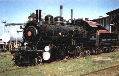
Above: Angelina County
Lumber Co. #110 c.1955 (collection of The History Center at Diboll, hat tip
Chino Chapa) This locomotive has been cosmetically restored and is now
on display at the Ellen Trout Zoo in Lufkin. |
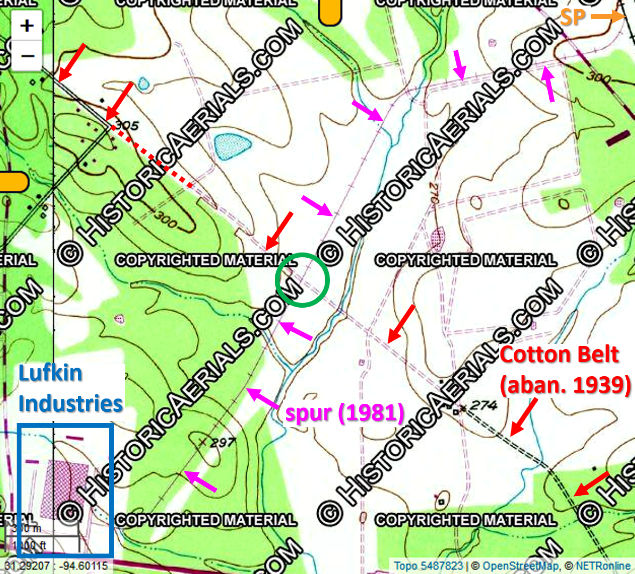
Right: In 1983, the ICC granted permission for A&NR to operate 2.79 miles of the SP main line south from Dunagan
to Buck Creek where a connection was made to a spur into a Lufkin
Industries manufacturing facility that had opened c.1981. The
facility was located on the north side of U.S. Highway 69, three miles
west of Huntington (a town named for C. P. Huntington, one of the founders of
SP.) This 1981 USGS topographic map shows the facility and the spur. Two
miles of spur tracks served the facility, but only the first 0.67 miles
off the main line was owned by SP; the remainder belonged to Lufkin
Industries. The spur crossed (green circle) the long abandoned Cotton Belt line
to White City.
In 1994, service to the Lufkin Industries facility ended.
Below Left: This 1955
aerial ((c)historicaerials.com) of Dunagan shows the connecting track
used by A&NR to reach Buck Creek and Zavalla that also facilitated the
T&NO's 1957 permanent reroute via Prosser.
Below Right: Two half-mile long track segments remain in use
at Dunagan for railcar storage. (Google
Earth, 2015)
 |
 |
The connector at Dunagan dates back to at least 1946,
probably for trackage rights to Zavalla. It was probably not
for emergency
reroutes to Dorr Jct. via Prosser because the northeast quadrant connector at
Prosser doesn't exist even as late as 1955. The northeast connector was
undoubtedly in place at Prosser for the 1957 permanent reroute, and it appears
to have remained intact until the reroutes terminated in the early 1990s. The T&NO line through Dunagan was part
of SP's Rockland Branch that ran from Beaumont to
Jacksonville. SP began abandoning this branch from
Beaumont toward Dunagan in 1991. The final track segment from Dolan to Dunagan,
23.2 miles, was abandoned in 1994. A&NR's request to the ICC to relinquish its
trackage rights to Buck Creek appeared in the Federal Register on October 13,
1994.
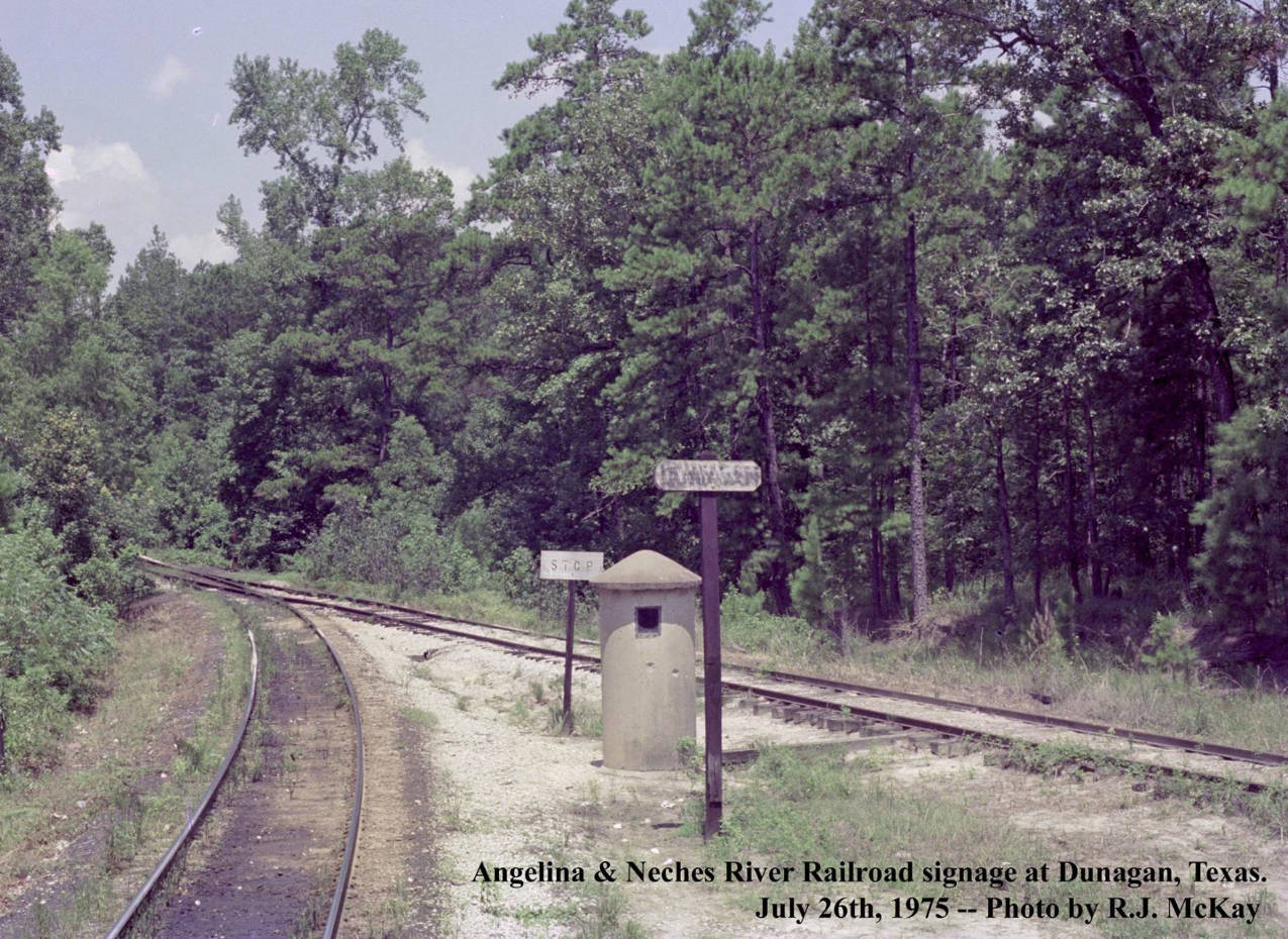
Above: R. J. McKay took this
photo at Dunagan in 1975 where the connector from the SP tracks joins the A&NR.
R. J. comments: "The
station sign is hard to read, but I believe this is Dunagan, Texas, a point on
the Angelina & Neches River Railroad. ... there is an SP style phone booth
there."