Texas Railroad History - Tower 111 - Trinity
A Crossing of the International & Great Northern Railroad and the Rock Creek
Lumber Co.
 |
Left: Railroad
Commission of Texas (RCT) records show Tower 111 located in the vicinity
of the town of Trinity at a crossing of the International & Great
Northern (I&GN) Railroad and a logging tram of the Rock Creek Lumber
Company (RCLC.) The precise location of the tower
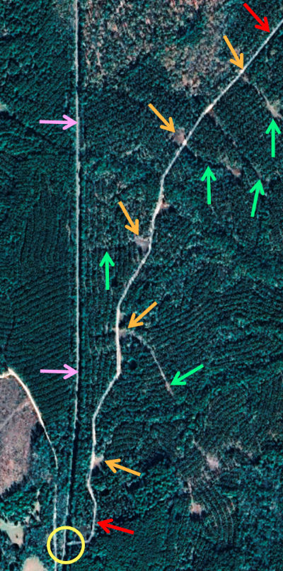
remains in question, but the best guess pertains to this "road" (red
arrows) just north of town. Google Maps has
artificially highlighted it on satellite imagery but does not
identify the road, even in the normal map view. Magnification shows it
to be nothing more than a "2-track" dirt road on a narrow right-of-way
through tall trees, with no obvious purpose
(e.g. houses, pond or river access, etc.) as it continues northeast off the
image. It has the appearance of a tram line cut through the forest,
curving somewhat randomly east to cross
Trinlady Park Rd. and continue toward the Trinity River.
Small parts of it are visible on 1958 aerial imagery, but the various
clearings (orange arrows) and cuts into the forest (green arrows) are
not. They are from more recent times, most likely to facilitate
harvesting logs, loading trucks and turning
them around. The working assumption is that the road is a
former tram right-of-way (ROW) from the 1920s that became overgrown and mostly
(but not entirely) invisible on late 1950s aerial imagery. It appears to
have been reused in more recent decades for forest access by logging
companies. If it was a tram road, might it have been
associated with the RCLC whose tram operated past Tower
111?
Below: An
employee timetable (ETT) of the Missouri Pacific (MP) Railroad,
Palestine Division dated October 30, 1932 (courtesy Missouri Pacific
Historical Society) lists the community of Red
Branch at milepost 55.8 on the I-GN rail line (pink arrows.) [Note that
the I&GN had become the "I-GN" in 1922 and had been acquired by MP in 1925.]
The interlocking for the RCLC tram is identified at milepost 63.0, 7.2 miles
south of Red Branch. Red Branch Rd. still crosses the former I-GN
rail line at grade, and aerial imagery from 1955 shows a small
settlement adjacent to the crossing. Assuming this crossing represents MP's
1932 location for Red Branch,
then measuring 7.2 miles south pinpoints the grade crossing (yellow circle) of the road
highlighted by Google Maps. If this was indeed a tram crossing in the
1920s, then it is very likely the site of Tower 111.
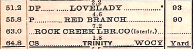
Can the opposite direction be measured? MP's ETT lists "Trinity" as the
next location south of Tower 111 at milepost 64.8, a distance of 1.8
miles. "Trinity" was presumably the town's passenger depot but it could
have been a freight depot or a yard office (or nothing at all, simply
the closest tenth of a milepost to downtown.) The distance from the road
crossing (yellow circle) to the site of the I-GN passenger depot is
about 1.66 miles. This is a bit shy of 1.8 miles, but t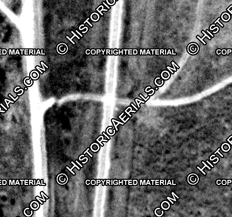 he uncertainty of
how MP defined "Trinity" along with the inherent imprecision
(a tenth of a mile) in the difference between any two places identified
by mileposts renders this error insignificant. he uncertainty of
how MP defined "Trinity" along with the inherent imprecision
(a tenth of a mile) in the difference between any two places identified
by mileposts renders this error insignificant.
Right: This 1958 aerial image of the
road crossing (yellow circle) of the I-GN tracks shows a tiny white dot in
the center of the image sitting in the southeast
corner of the crossing (just above the letter 'E'.) This looks remarkably
like a small equipment cabin, the kind a railroad would use to house
an interlocking plant. Its close proximity to the rail line guarantees that it is railroad related. The Tower 111 cabin had
likely been decommissioned in the early 1930s, perhaps 25 years before
the 1958 aerial imagery was captured. Railroads have been known
to leave decommissioned interlocker cabins trackside for long periods of
time (e.g. Tower 213,
Tower 142, and -- forty years with neither
track intact -- Tower 179.)
((c)historicaerials.com) |
The rail history of the town of Trinity begins with construction of
the Houston and Great Northern (H&GN) Railroad. One of the early
railroads in Texas, construction moved north out of
Houston in 1871. In 1872, the H&GN passed through the new town of Trinity, named for its county
and the Trinity
River nearby. The following year, the International & Great Northern (I&GN)
Railroad was formed by the merger of the H&GN with the International Railroad,
whose main line ran from Longview to Hearne, later extended
south through
Austin and
San Antonio to Laredo. The merger was approved by
the Legislature in 1875. The two railroads intersected at
Palestine which became the location of the I&GN's
principal maintenance facility.
By 1881, the I&GN was the largest railroad in
Texas. Its access to St. Louis via connections at Longview and Texarkana
with other railroads
was a boon to commerce between Texas and the Midwest. Lumber interests wanted to
connect with it to reach northern and eastern markets via St. Louis. One such railroad was the Trinity & Sabine (T&S) Railway
chartered at Trinity in 1881. Its plan was to build east into the
vast forest north of Beaumont to bring lumber
products to Trinity for shipment on the I&GN, either north via St. Louis or south
to Houston and the Port of Galveston. After 38 miles of track had been laid, the T&S was
acquired in December, 1882 by rail baron Jay Gould and resold immediately to the
Missouri, Kansas & Texas (MK&T, "Katy") Railway of which Gould was President
(since December, 1879.) Gould was looking to increase lumber traffic on the I&GN
which he had acquired in June, 1881 in a swap for Katy stock. Although the stock
swap gave the Katy corporation ownership of the I&GN, this fact was obscured
by Gould to avoid scrutiny. He was concerned it was a violation of Texas railroad
ownership laws since the Katy was headquartered in Kansas. A complicating factor was that Gould owned very little Katy stock.
He had
leased the Katy to MP in December, 1880 to enable Katy profits to
be moved to MP's books, to his significant financial benefit (he had controlling
interest in MP.) This was entirely detrimental to Katy stockholders who
eventually realized
their railroad was simply breaking even each year despite excellent performance. Gould
named himself President of the I&GN and proceeded to lease it to the Katy so its
profits could flow to MP as well.
Gould's position
as President of the Katy was precarious because he was vulnerable to collective
action by Katy stockholders ... if they could ever summon a quorum to a meeting
(which Gould worked diligently to prevent.) In 1888, Gould was fired by a majority of an assembled quorum of angry Katy
stockholders upset with the terms under which the Katy had been leased to MP. The Katy's new management
immediately sought bankruptcy protection and was able to obtain a court ruling
that abrogated the lease to MP. The Texas Supreme Court affirmed the lower court
order breaking MP's lease, but the Court
also ruled that the Katy did not have a Texas railroad charter, hence its
expansion in Texas under Gould (from Denison south
to Taylor) had been unlawful. It fell to the Legislature to
solve the problem. They did so in October, 1891, passing a railroad charter law establishing a Texas-based Katy subsidiary to own the tracks the Katy had
built in Texas. By this time, the Katy's ownership of the I&GN was public
knowledge, and the new charter required the Katy to sell the I&GN -- the
Legislature did not want Texas' largest railroad owned by an out-of-state
company. Gould was
the only viable bidder, hence he was able to
buy it for the meager sum of $350,000. When Jay Gould died in December, 1892,
his son George took over the family business and became President of the I&GN.
The
1891 charter law formally integrated the T&S into the Katy railroad as
its Sabine Division. Several years earlier in 1884, Gould had directed the Katy to extend the T&S tracks
29 miles east to Colmesneil. This resulted in the Sabine Division having
connections with three major railroads: on the west end at Trinity with the
I&GN; on the east end at Colmesneil with the Texas & New Orleans (T&NO) Railway,
a Southern Pacific (SP) property; and between the two at Corrigan with the
narrow gauge Houston East and West Texas (HE&WT) Railway (converted to standard
gauge in 1894 and acquired by SP in 1899.) Unfortunately, none of
these connections were with the Katy's route network, thus the Sabine Division
became known as the Orphan Branch of the Katy.
 |
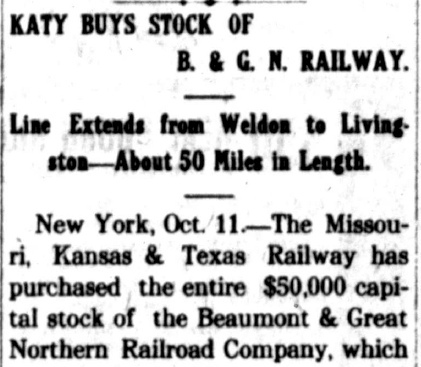
In 1905, a new railroad was
chartered as the Beaumont and Great Northern (B&GN) with plans to build from
Trinity southeast to Livingston, ostensibly continuing to Beaumont. Construction
to Livingston (33 miles) was accomplished in 1907-08, and the line
was extended 16 miles west from Trinity to Weldon in 1911. Shortly thereafter, the B&GN
was sold in successive transactions and was ultimately acquired by the
Katy in 1912. The sale to the Katy was fought in court by the State of Texas and
was eventually
annulled in a 1914 settlement wherein the Katy leased the B&GN for 99 years.
This gave the Katy three lines extending out from Trinity: a 15-mile line
northwest to Weldon, a 33-mile line southeast to Livingston, and the 67-mile
Sabine Division east to Colmesneil via Groveton and Corrigan.
Left: The
Galveston Tribune
of May 6, 1910 reported RCT's
refusal to postpone an order requiring the B&GN to install an
interlocking plant at its crossing of the I&GN south of downtown
Trinity. The Tribune was
an afternoon newspaper; it appears that "Special to The Tribune" was a
code phrase indicating that the story was copied verbatim (with permission) from
that day's morning edition of the Austin
Statesman.
Despite RCT's refusal to postpone its
order, there is no evidence that an interlocker was ever installed at
the B&GN's crossing of the I&GN. No other newspaper stories on
the topic have been found. The crossing was probably gated as there
would have been no need for Weldon - Livingston through trains that did
not also stop at Trinity. Thus, the delay of a complete stop at the
diamond to reposition the gate would have had virtually no impact on
B&GN operations. The normal gate position would be open for I&GN trains
which would approach the crossing at restricted speeds to verify it was
open. A 1918 I&GN ETT lists the B&GN crossing at Trinity,
but mentions neither an interlocker nor a gate. The crossing does not
appear at all
in MP's 1932 ETT. Historic imagery from the 1950s shows there had been
connecting tracks in three of the four quadrants, omitting only the
southwest quadrant. |
| Right:
The Crockett Courier of
October 24, 1912 carried a news story announcing and explaining the
Katy's purchase of the B&GN. |
 |
 |
 |
 |
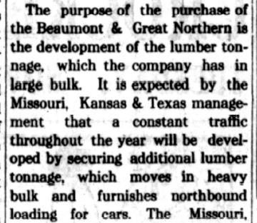
In 1913, there was industry speculation that the
Katy was planning to extend some of its Texas lines. One such report
appeared in The Railway and Engineering Review
of March 29, 1913 (below)
regarding the Katy's B&GN line to Weldon being extended fifty miles
northwest to Jewett. There, the I&GN's Longview - Laredo main line crossed
two other railroads: the Trinity & Brazos Valley and SP's Mexia -
Nelleva Cutoff. Construction was supposedly underway, but no such
route was ever built.

The Katy went into receivership in 1915. As it emerged from bankruptcy
in 1923 (with a new
corporate name, the Missouri - Kansas - Texas Railroad, "MKT", but still
"the Katy") the lease was canceled and control of the B&GN reverted back
to its owners. The owners changed the B&GN's name
to the Waco, Beaumont, Trinity & Sabine (WBT&S). Within a year, the WBT&S had acquired the Katy's Sabine Division
(Trinity to Colmesneil via Groveton and Corrigan) which had been omitted
from the Katy's reorganization plan. By 1924, the WBT&S had essentially
reconstituted the Katy's Orphan Branch. The Trinity - Colmesneil tracks were abandoned in 1936 and the
line to Weldon was abandoned in 1940. The tracks to Livingston were cut
back in part during 1949, leaving 18 miles southeast from Trinity
intact. This remainder was abandoned in 1961.
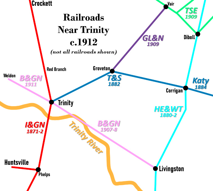
Right:
This map shows railroads near Trinity c.1912 and when they were built. Lumber trams are not shown.
Diboll became a major sawmill town, founded
northeast of Trinity in 1894 by Thomas L. L. Temple. In 1900, Temple
chartered the Texas Southeastern (TSE) Railroad to convert
Temple's logging trams into standard gauge rail lines. The TSE's rail
lines are no longer in use, but the railroad continues to switch the
mill at Diboll. In 1909, the Groveton, Lufkin & Northern (GL&N)
was chartered to establish a standard gauge rail line between Groveton
and Vair. The right-of-way had been a lumber tram owned by the Trinity
County Lumber Co. The GL&N also operated into Lufkin (north of Diboll)
over TSE tracks. It ceased operating in 1931. |
 |
In 1910, the Thompson Brothers established a sawmill at
Trinity. The Thompson family had been a major player in the Texas lumber
industry for
multiple generations and was one of the first to recognize the
wisdom in separating their land ownership from their lumber production. This
allowed independent decision-making by the land owners and lumber
producers, usually resulting in better long term success for both during
periodic boom and bust economic cycles. To implement this strategy, the Thompson Brothers
converted their existing lumber companies into land-holding companies and
founded two new lumber companies, Texas Long Leaf Lumber Co. and Rock Creek
Lumber Co., in which they retained only a minority stake. The August 10, 1917
edition of Lumber World Review reported that
the Rock Creek Lumber Co. was formed with $500,000 of initial capital by J. W. Ferguson
, J. W. Reynolds and H. H. Thompson (who is listed as a resident of Trinity.) The Thompson Brothers
mill at Trinity and various timber rights were then sold to Rock Creek Lumber Co.
for "in excess of $2,000,000" according to the September 1, 1917 issue of
The Lumber Trade Journal. The Texas
Transportation Archive lists the RCLC tram as "Standard-gauge. Operating by 1917 to at least 1928. Length, 11 miles.",
but when and where it was constructed is undetermined.
Eventually, the Rock Creek Lumber Co. was consolidated with the Texas Long Leaf
Lumber Co., which operated the mill at Trinity until it closed in 1955.

Above: The January, 1920
edition of Railway Signaling & Communications
published a table of new or modified interlockings completed in 1919, a list
that included the new interlocker installed at Trinity for a crossing of an
unidentified "logging road" and the I&GN. The table does not
identify the "logging road" but it was undoubtedly the RCLC. The I&GN is attributed with
responsibility for the interlocking, and the isolated '3' indicates there were
three levers in the cabin to be operated by a crewmember whenever a tram
needed to cross. Note that only the I&GN portion of the interlocking is
identified as "Electrical". Presumably the levers in the cabin mechanically
controlled the derails on the tram tracks while electrically controlling the
signals and derails on the I&GN line.
Documents in the RCT archives maintained at DeGolyer
Library, Southern Methodist University state that Tower 111 was placed in
service on November 13, 1919, at "...Mile 65, just north of Trinity Station."
"Mile 65" is confusing and likely a mistake. Milepost 65 was in downtown Trinity roughly a thousand feet
south of the station, not "north of Trinity
Station". MP's 1932 ETT identifies the RCLC tram crossing at Milepost 63,
about 1.8 miles north of "Trinity", presumably MP's reference for Trinity
Station. And a 1918 I&GN ETT shows that the milepost markers on the 1932 MP ETT
had not changed. Ironically, Mile 65 was very close to the B&GN / I&GN
crossing for which RCT's 1910 order for an interlocking was apparently never
executed. The B&GN was not a "logging road"; the journal surely would have mentioned the B&GN if it was involved in the
interlocking.
RCT's table of active interlockers published annually confirms the November
13, 1919 date for the commissioning of Tower 111 and identifies it as an
8-function mechanical cabin interlocker. The DeGolyer documents report that Tower
111 had two levers for six signals -- presumably two distant and two home
signals on the I&GN and two home signals on the tram line. There was one lever
that covered two derails and two "locks", but precisely how the
derails were allocated and controlled, and what, specifically, was being locked is undetermined. (The
locks could have been facing point locks, but only if there was a
switch on the I&GN for a connecting track to the tram line -- an unknown
detail.) The I&GN
undoubtedly had derails in both directions, but whether the tram did also is
undetermined. A note dated October 22, 1919 found in the Tower 111 file states that
the interlocking plant is "...identical with the one constructed by the
Walker County Lumber Co. near Elmina...". The note also states that
RCLC was waiting for approval to install the diamond for its track to cross the
I&GN.
The notation
regarding Elmina is interesting. Elmina was ten miles south of Phelps near New
Waverly, about 31 miles south of Trinity. Although no interlocker anywhere near Elmina
was ever incorporated into RCT's numbering system (the closest being at
Conroe 18 miles farther south), the 1918 I&GN ETT includes "Walker
County Lumber Co., Elmina (Interlocked)" in a list of railroad crossings on
the Palestine Subdivision. Elmina may have been a "temporary interlocking"; RCT is known to have approved
at least one such interlocking, at Cruse, that
was never incorporated into RCT's numbering system. (Presumably, others remain to be discovered.) There is evidence that
Tower 143
at Devers might have initially operated as a temporary unnumbered interlocker for several years. RCT information
regarding a plant at Elmina has not been found. Oddly, a note in the 1918 ETT states "Elmina
is flag stop for Nos. 4 and 5 and is a regular stop for Nos. 3 and 8."
yet
Elmina is not listed in the timetable!
Tower 111 was the first interlocking plant
commissioned by RCT that involved an actual logging tram. Such trams were numerous in east Texas and for many years were completely uncontrolled.
How did the railroads and logging companies evade the 1901 law granting RCT
authority to regulate crossings? The law applied "when one railroad seeks to
cross the tracks of another railroad company", but logging companies
were not railroads! The railroads eventually decided it was to their benefit to
secure these crossings and they began relying on swing gates and restricted speeds to provide
a modicum of operational safety. The trams had no choice but to cooperate; they
did not have state railroad charters, hence they had no means to force a
railroad to allow them to install a crossing. When the idea of
interlocking these crossings began to take hold, RCT got involved to assert
authority to approve all interlockings on Texas
rail lines, regardless of the circumstances. [RCT's zealous protection of its
authority over all interlockers arose initially in the context of yard tracks
for Towers 116 and 117
(which, despite higher numbers, preceded Tower 111.) RCT reinforced its
authority with Tower 121, and expanded it in 1927
with the double-track interlocker at Canyon.] The tram interlockings that
followed Tower 111 were Tower 113 at Hyatt,
Tower 143 at Devers and Towers 178 and 180 near
Magnolia.
There were also tap lines -- most of them converted tram lines -- that
crossed Class 1 railroads, and many of these were interlocked. A tap line
was simply a chartered and incorporated common carrier railroad owned
by a lumber company (or its closely related interests, e.g. management /
investors.) Tap lines moved logs inbound to the mill and wood products outbound to
interchanges with trunk line railroads while also serving the general
population along its routes. Converting a tram line to a tap line realized two
major benefits -- it would no longer be
restricted to hauling logs and company supplies, and it would share in the trunk
line revenue for all shipments, inbound and outbound. By accepting the benefits
of common carrier status, the tap lines also accepted two significant
legal obligations. They had to offer transportation services to the public
without discrimination, and they had to set public tariffs and charge fees for
their services. [Charging fees might seem obvious... except that lumber trams
did not charge their owners for moving logs to sawmills -- trams were simply
part of the logging enterprise. As a common carrier, a tap line that continued to move logs
for its owners at no charge had to offer the same free service to other
sawmills along its tracks!] Tap lines were involved with Tower 11
at Orange, Tower 110 at Dayton,
Tower 123 at Jefferson,
Tower 125 at Mauriceville, Tower 148 at Fullerton,
Tower 182 at Lufkin and
Tower 185 at Diboll.
 |
 |
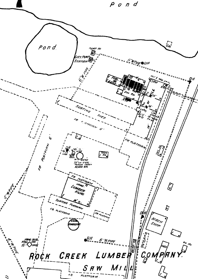
Above Left: The 1925
Sanborn Fire Insurance map of Trinity includes this detail of the Rock Creek
Lumber Co. located on the north side of Trinity. The cartographer drew the map
with 15 degrees of rotation to the east (right) causing the two WBT&S rail lines
on the mill grounds to appear to be on a slight northeast heading when they were
mostly running slightly northwest. The left rail line was a spur off the mill
track and is shown terminating adjacent to the saw facility whereas the mill
track continues off
the north end of the map. Its grade appears to form the eastern boundary of
the larger mill pond located north of the sawmill.
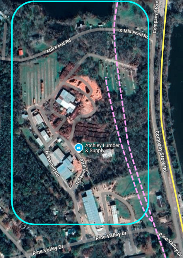
Above Right: This recent
Google Maps satellite image has been annotated to show the RCLC
site (blue rectangle) and the WBT&S rail lines (pink dashes) into the facility.
The former I-GN tracks (yellow line) are now owned by Union Pacific (UP) and are
still operated as a main line between Houston and Palestine. UP acquired MP in
1982; MP had acquired the I-GN in 1925 and had fully merged its operations in
1956.
 |
Left: This 1958 aerial image ((c) historicaerials.com) has been
annotated to show the location (pink circle) of Mill Junction 200 ft. north of Church St.
(the east / west street visible immediately
south of the switch.) The WBT&S main line (pink arrows) came north along
Maple St. and curved northeast at the switch; the mill track (blue
arrows) continued north. Farther north, the I-GN tracks (yellow arrows)
came very close to the mill but no evidence of direct I-GN access into
the facility has been found.
At the outset, the WBT&S
reconstituted the former Katy Orphan Branch including the line to
Colmesneil via Groveton and Corrigan (green arrows.) That line came out
of the I-GN yard which in 1925 had at least five parallel tracks
according to the Sanborn Map. It appears that the I-GN allowed its yard
tracks to be used by the WBT&S to connect the Groveton line with the
ex-B&GN Weldon - Livingston line farther south. The image also shows a
connecting track (orange arrows) for the Groveton line that switched off
the I-GN. The WBT&S shops were located in this area.
 Left:
The WBT&S was nicknamed "Wobbly, Bobbly, Turnover and Stop" for the
rocking trains that ran slowly over its poor roadbed. The name stuck, so
much so that when the abandoned WBT&S ROW was repurposed as a county
road west of Livingston, the new road was called "Wobbly Bobbly Tram"
(an inaccurate name; it might have been a tap line at some point, but it
was not a tram.) The name remained in use as recently as 2018 as shown on this
Google Maps snippet. Early on, a portion of the new road was named
"Chris Brent Rd.", and Google Maps now shows that to be the exclusive
name for the entire length of the former Wobbly Bobbly Tram roadway.
Near Livingston, the WBT&S ROW was repurposed to become Pridgen Rd.
Although Pridgen and Chris Brent roads are co-linear -- the WBT&S ROW
was perfectly straight in this area -- they do not connect due to a 0.7
mile gap where the county opted not to bridge East Temple Creek. Left:
The WBT&S was nicknamed "Wobbly, Bobbly, Turnover and Stop" for the
rocking trains that ran slowly over its poor roadbed. The name stuck, so
much so that when the abandoned WBT&S ROW was repurposed as a county
road west of Livingston, the new road was called "Wobbly Bobbly Tram"
(an inaccurate name; it might have been a tap line at some point, but it
was not a tram.) The name remained in use as recently as 2018 as shown on this
Google Maps snippet. Early on, a portion of the new road was named
"Chris Brent Rd.", and Google Maps now shows that to be the exclusive
name for the entire length of the former Wobbly Bobbly Tram roadway.
Near Livingston, the WBT&S ROW was repurposed to become Pridgen Rd.
Although Pridgen and Chris Brent roads are co-linear -- the WBT&S ROW
was perfectly straight in this area -- they do not connect due to a 0.7
mile gap where the county opted not to bridge East Temple Creek. |
The Texas Forestry Museum Sawmill Database associates the RCLC tram
with "Sequoyah, just north of Trinity, in Trinity
County". Sequoyah was a stop on the WBT&S main line toward Weldon
about 0.9 miles northwest of Mill Junction. This would place it along Highway 19
near the Most Holy Trinity Catholic Church, very close to where the mill was
located. The tram was based at the mill, and it appears that Sequoyah
is just a slightly more accurate location for the mill than Trinity.

Above Left: This
map snippet is taken from a plat of property owners at Trinity located by the
Texas Transportation Archive On-Line at the Trinity County Courthouse in
Groveton. The I&GN (yellow) and B&GN (pink) tracks are highlighted with the
assumption that the B&GN owned the tracks that continue north from the mill and
turn west to reach the line to Weldon. The map is believed to date from the
1910-1915 timeframe, but unfortunately, is not drawn to scale and is misleading.
As shown in the 1958 aerial image further above, Mill Junction is farther north
than the switch off the I&GN for the track to Groveton whereas this map shows it
well to the south. After the B&GN crossed the I&GN, it curved to a due north
heading up Maple St. to Mill Junction whereas this map shows it on a northwest
heading to Mill Junction. Above Right:
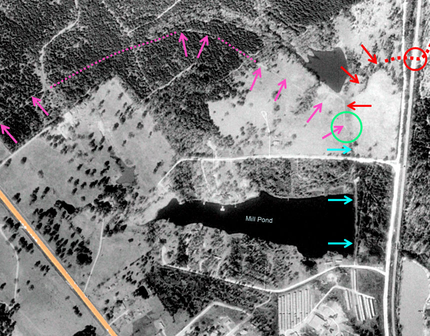
This 1989 Google Earth imagery has been annotated to show the potential route of
the WBT&S (B&GN) right-of-way (pink arrows and dashes) north of the mill. The route
raises the possibility that a short section of the track (blue arrows) might
have been shared with the RCLC tram (red dashes.) Doing so would have required a
switch (green circle) between the Mill Pond and a smaller pond farther north. Unfortunately,
historic aerial imagery of this area from the late 1950s is inconclusive due to
a large span of disturbed earth between the two ponds.
The Texas Historical Society held an event at the Most
Holy Trinity Catholic Church on May 29, 2016 to unveil a new
historical marker for the Texas Long Leaf Lumber Company which took over the
RCLC some time between 1928 and 1943. According to the
Trinity Standard of June 2, 2016, the marker
was to "...be placed at the site of the 'Old Mill' with a base constructed
out of bricks from the building itself..." that were salvaged when the mill
was razed in the 1950s. The marker is located adjacent to the Most Holy Trinity Catholic
Church at the intersection of State Highway 19 and Pine Valley Drive.