Texas Railroad History - Tower 135, Canyon and Tower
188, Farwell
Two Junctions to Lubbock on the Panhandle
& Santa Fe Main Line
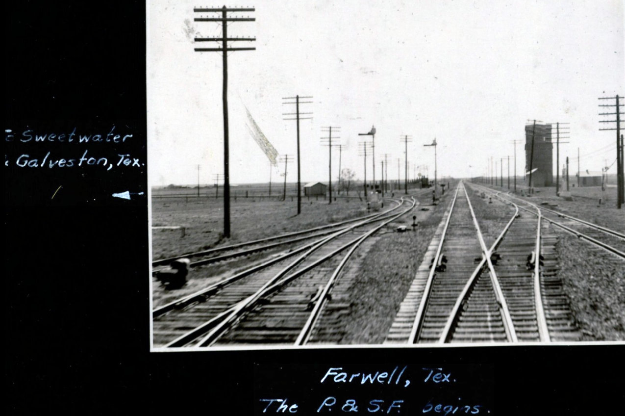
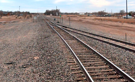
Above: On May 5, 1940,
railroad executive John W. Barriger III took this photo facing west from the
rear platform of his business car as his train proceeded eastbound on tracks of
the Panhandle & Santa Fe (P&SF) Railway. When Barriger went through his
developed film post-trip to make annotations, he mistakenly identified this
location as Farwell, a tiny Texas community at the New Mexico state line where
eastbound trains effectively transition from the Belen Cutoff onto the P&SF
("The P&SF begins.") Barriger's camera instinct had been provoked by tracks
coming in from the left to merge onto the Belen Cutoff (westbound) and the P&SF
main line (eastbound). Barriger's annotation notes that the junction leads to
Sweetwater and Galveston, hundreds of miles southeast of Farwell. The track to
the left does indeed lead to Sweetwater and Galveston, but the photo was not
taken at Farwell. It was taken at Lubbock Junction in Canyon, Texas, 77 miles
east of Farwell. The telling detail is that at Farwell, the track from
Sweetwater joins the P&SF at the beginning of a significant curve across the
state line into the community of Texico, New Mexico and the Belen Cutoff, a curve not present in this
photo. Unlike Farwell, the main line at Canyon remained perfectly straight as it
passed near and through the junction leading to Lubbock, Sweetwater and
Galveston.
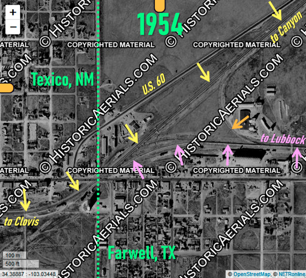
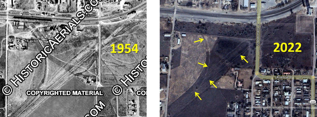
Below Left: This 1954 image
((c)historicaerials.com) shows the Santa Fe main line (yellow arrows) at the
Texas / New Mexico border (green dashes). On the Farwell side, the line from
Sweetwater and Lubbock comes in from the east (pink arrows) and crosses into
Texico, New Mexico followed immediately by a
curve to a due west heading toward Santa Fe's yard and maintenance base at
Clovis, nine miles farther west. This
curve is not present in Barriger's photo above, clarifying that his Farwell annotation
was a mistake. A connecting track (orange arrow) for the opposite direction
supported switching movements for local freights. Below
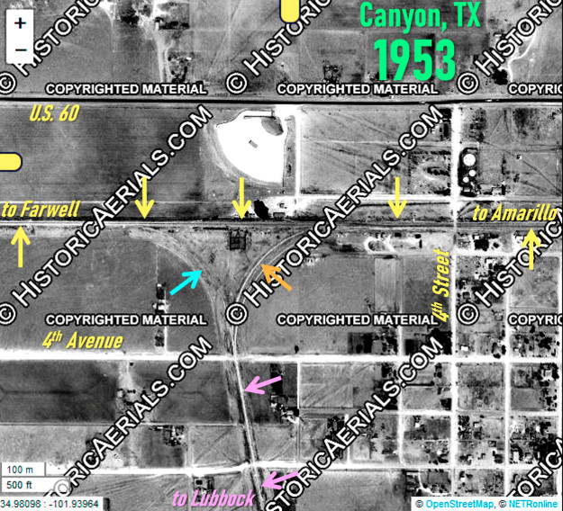
Right: This 1953 image ((c)historicaerials.com) of Lubbock
Junction at Canyon shows the P&SF main line (yellow arrows) running due east /
west on the west side of town. The line from Lubbock and Plainview (pink
arrows) approaches from the south on a nearly due north heading. It is apparent
from the image that the east connecting track (orange arrow) was being
maintained to a much higher standard than the west connector (blue arrow) due to
frequent movements on the east connector for Amarillo / Lubbock traffic.
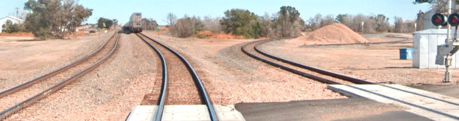
Above: Looking north
from the 4th Avenue grade crossing in
Canyon, this Google Street View image from May, 2013 shows that the track into Lubbock Junction
now splits south of 4th Avenue; in the 1953 image above, the switch was barely
north of 4th Avenue. The west (left) connector appears to be in better shape
than it was in 1953 but still not maintained to the same quality as the east
connector. In the
distance, an intermodal train is passing through Canyon on the former Santa Fe
main line, now owned by Burlington Northern Santa Fe (BNSF).
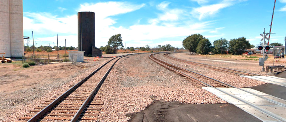
Below Left: Looking south from
the same location as above, the connectors combine into a single track going south to
Plainview and Lubbock, continuing to Sweetwater and Galveston. The "straight through" route is the east connector which
is used for Amarillo / Lubbock traffic.
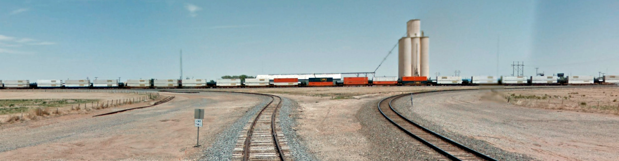
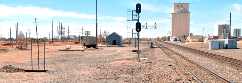
Below Right: As noted by the sign on the left side of
the image, this Google Street View (March, 2022) was captured at "Lubbock Jct."
in Canyon. It was taken from the 4th Street grade crossing facing due west
toward Farwell, 77 miles distant. The switch visible on the south (left) track
across from the equipment cabinets on the right is the east connector leading
south toward Plainview and Lubbock. The corresponding west connector is barley
visible in the distance curving onto the south track. The large pink building
trackside at right might be the same building in Barriger's photo at top of
page, or perhaps a successor.
 |
Left Top:
This Google Street View from October, 2021 was taken from the U.S. Hwy
84 grade crossing over the BNSF tracks at the New Mexico / Texas state
line. The camera is facing northeast into Texas toward the tail end of
an intermodal train that is passing through Farwell on BNSF's double
main line toward Canyon and beyond. The track curving to the right is
the line to Lubbock, Sweetwater and Galveston. It
opened in March, 1914 when it was known as the Lubbock - Texico Cutoff.
Left Bottom:
This view in the opposite direction faces southwest into Texico, New
Mexico. It was captured simultaneously with the image above by Google
Street View. The major yard at Clovis is about nine miles distant around
the bend of the curve which takes the line to a due west
heading. Notice that the Lubbock track (far left) no longer intersects the main
line here. Instead, it continues for nearly two miles before finally
merging onto the south track. Before the Belen Cutoff opened in
1908, there
was no curve here at all. The tracks simply continued southwest on a
direct heading for Portales and Roswell. Now, those towns are reached by
a track segment running 8.7 miles due south from Clovis that intersects
and curves to the southwest to rejoin the tracks on the original right-of-way to Portales. |
Canyon was named for its proximity to the spectacular
Palo Duro Canyon.
Originally known as Canyon City, the town's humble beginnings were in a dugout built by Lincoln
Connor c.1887, his home also serving as a general store. With the organization
of Randall County in 1889, Canyon became the county seat. By 1896, a weekly
newspaper had survived long enough to be published regularly (becoming known as
the Canyon City News in 1903.) The town received
rail service in 1899 when the Pecos & Northern Texas (P&NT) Railway
laid tracks to Amarillo from Farwell on the New Mexico state line,
the Texas portion of a lengthier route originating in Roswell, New Mexico.
The P&NT was the brainchild of noted railroad developer James J. Hagerman
who had decided to build northeast from Roswell.
Hagerman was an industrialist known best for developing mines and railroads in
Colorado, New Mexico and Texas. [He does not appear to have been directly
related to James Hagerman, the General Solicitor for the Missouri, Kansas &
Texas Railroad who was active in railroading at the same time.] In 1890, Hagerman built the Pecos Valley Railroad
between Pecos, Texas and Roswell (legally chartered on the Texas side of the
border as the Pecos
River Railroad.) Hagerman expected agricultural products from the Pecos
River Valley near Roswell to find commercial outlets in
Fort Worth and El Paso via the Texas & Pacific
(T&P) Railway connection at Pecos. The results were disappointing and Hagerman came to understand that the proper outlet for Pecos
Valley crops and livestock was the Midwest. By 1896, he had begun
planning a lengthy rail line from Roswell to the Texas Panhandle. His objective
was to make a connection with the Atchison,
Topeka & Santa Fe (AT&SF) Railway through its Texas subsidiary, the Southern Kansas Railroad (SKR).
SKR tracks in the Panhandle led northeast through Oklahoma into Kansas,
eventually reaching the major Midwest rail junction at Kansas City.
The obvious
SKR connection for Hagerman was at
Washburn, a tiny community fifteen miles east-southeast of Amarillo. The SKR's
nearest tracks were fifteen miles northeast of Washburn at Panhandle City, but
years earlier, the Panhandle Railway had been built between the two towns.
Washburn was significant only because it was on the Fort Worth & Denver City Railway (FW&DC, but mostly just FW&D
-- "City" was formally dropped in 1951.) The FW&D had leased the
Panhandle Railway when Washburn was being promoted as a major future rail junction serving the FW&D and
Santa Fe. In 1891, Santa Fe had begun looking at routes out of Washburn toward the South Plains of the Texas Panhandle
and into New Mexico, stoking
the fires of Washburn's promoters and landowners. Santa Fe chose not to build
beyond Washburn; instead it agreed to
help Hagerman finance his line to the Texas Panhandle. Hagerman followed up on Santa Fe's
prior discussions with Washburn landowners, requesting a $20,000 bonus and half of the
townsite in exchange
for creating what would undoubtedly become the major railroad junction in the
Panhandle. Washburn negotiators drove a hard bargain, willing to grant
right-of-way (ROW) for tracks and land for depot facilities, but nothing else.
In their view, Hagerman had no other option. In railroad circles, it was known
that Hagerman preferred to connect at Amarillo, the commercial center of the
region, but the SKR had no tracks at Amarillo.
At some unknown date (and
certainly no later than the summer of 1897), Amarillo civic leaders got
wind of Hagerman's plan to connect at Washburn and were absolutely
flabbergasted at the possibility that a major railroad, Santa Fe, would
bypass Amarillo -- a much larger town than Washburn -- by
only fifteen miles. Amarillo dispatched local attorney Squire
Madden to meet with Santa Fe officials at
their Chicago headquarters. The date of this meeting is undetermined;
the Handbook of Texas asserts that it
was sometime in 1896. Madden's mission was successful; Amarillo agreed
to pay $20,000 for the railroads to change their connecting point, even
though Santa Fe had no tracks at Amarillo. Santa Fe did, however, have
trackage rights on the FW&D between Washburn and Amarillo, rights the
FW&D had sold only because it expected Santa Fe's major junction to be
at
Washburn. Instead, Hagerman's railroad would connect with Santa Fe at
Amarillo and the FW&D tracks would carry Pecos Valley traffic on
Santa Fe trains between Amarillo and Washburn.
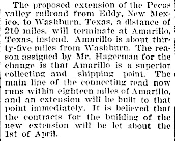
Right: This article in the
Fort Collins (Colorado) Courier of
March 24, 1898 narrows the timing of when Hagerman changed the
connecting point to Amarillo (only fifteen miles from Washburn, not
"thirty-five.") The decision was probably made a few months earlier in
the latter part of 1897, time used for revising the ROW and securing
easements. As for the extension between
Amarillo and "the
main line of the connecting road" (Santa Fe's terminus at Panhandle City), it was built
"immediately" ... if "immediately" means "ten years from now". |
|
 |
Modifying the alignment for a direct route to Amarillo from the New Mexico
border would have meant bypassing Canyon City. Instead, the route was maintained
into Canyon City and then revised abruptly north toward Amarillo. In
A Branch Line Comes of Age, Part
Two, author Bob Burton explains why the route through Canyon City was retained:
Southwest of Amarillo
there was a choice of a direct route passing north of Canyon or of a longer line
through that town. Landholders at Canyon and southwards threatened to deny water
to the railroad if it missed Canyon, so the longer route was chosen.
Hagerman proceeded to obtain a Texas railroad
charter in 1898 for the P&NT which would own the Texas portion of his route as
required by state law. From a Pecos River crossing near Roswell, Hagerman's
original survey had planned to maintain a general 55-degree heading for 200
miles to Washburn, a heading that would pass through Canyon and proceed
northeast
along the north side of Palo Duro Canyon. Where the ROW crossed into Texas, the surveyors
elected to stay north of the Tierra Blanca Creek drainage which brought
the line slightly farther north than needed for the route into Canyon. Near Umbarger,
the heading was adjusted slightly to the east toward Canyon; a second adjustment
on the outskirts of Canyon sent the right-of-way due east through town.
Instead of continuing toward Washburn, the
revised ROW out of Canyon turned north to Amarillo, which the P&NT reached in 1899.
While the P&NT owned the tracks in Texas,
they were operated by a railroad Hagerman had reorganized from his Pecos Valley
Railroad for the new line, the Pecos Valley and Northeastern (PV&NE). Santa Fe bought all of Hagerman's Texas and
New Mexico rail interests in 1901, and several years later, elected to use
the P&NT charter for track expansion into the South Plains.
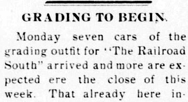
Right: Construction of "The Railroad South"
began in February, 1906. (Canyon City
News, February 16, 1906)
With the P&NT in its
fold, Santa Fe wanted to build into the South Plains
region south of Canyon, a cattle ranching area with increasing production of
wheat and cotton.
Plainview and Lubbock were the only towns of any
size; both were small and neither had rail service.
Plainview had been founded c.1886 through the efforts of two settlers, Z. T.
Maxwell and Edwin Lowe, who had simply decided to establish a town near their
land. Lubbock was another 42
miles farther south, the county seat of Lubbock County. It had been founded by
land promoters in 1891, although a Lubbock Post Office had been granted for a
tiny outpost in the county in 1884. |
 |
 |
 |
 |
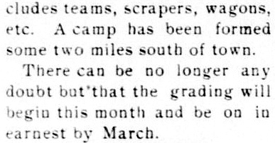
Left: The
Canyon
City News of Friday, January 4, 1907 reported the arrival of
the first train into Plainview the prior Saturday, December
29, 1906. Note that the "officials" were from the "Pecos Valley"
(PV&NE),
i.e. the P&NT simply held title to the tracks Hagerman had built in Texas;
it was
the PV&NE (based in New Mexico, owned by Santa Fe) that actually used them.
PV&NE operations over the P&NT persisted until 1914 when the SKR was renamed the Panhandle & Santa
Fe (P&SF) Railway. All of Santa Fe's west Texas operations
(including the PV&NE's operations on the P&NT) were consolidated
under the P&SF.
Since the P&NT owned the majority of the tracks the P&SF was using, it was
leased to the P&SF and then formally merged in 1948. The P&SF was merged
into the parent AT&SF on August 1, 1965. |
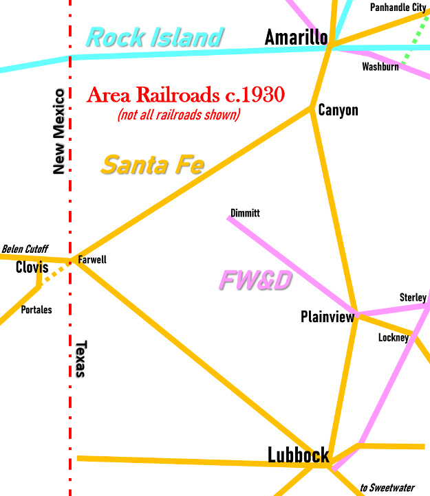 |
Left: Railroads
in the Amarillo - Lubbock - Clovis triangle c.1930
In 1908, Santa Fe
opened the Belen Cutoff which intersected the Roswell - Amarillo main
line at Farwell. The Cutoff
provided a shortcut for Kansas City / Los Angeles traffic across eastern New
Mexico to connect with Santa Fe's Los Angeles
main line at Belen, south of Albuquerque. West coast traffic began moving between Belen
and Kansas City via Farwell and Amarillo instead of the existing route through Raton Pass on the New
Mexico / Colorado border. The new town of Clovis was
established in 1907 by Santa Fe to host major switching and
maintenance facilities. To coincide with the opening of the Cutoff, Santa Fe rerouted the PV&NE to turn north into
Clovis. (Clovis had not been bypassed -- it simply didn't exist when the original line
through Farwell had been built
in 1899.) Santa Fe proceeded to abandon the tracks between Farwell and the
connecting point south of Clovis (orange dashes.)
The opening of the Belen
Cutoff also coincided with Santa Fe commencing operations on a new track
extension from Panhandle City to Amarillo. Ten years earlier, the SKR had leased the
Panhandle Railway and then acquired it in 1900. Pecos Valley traffic
destined for Kansas City had been making the jog from Amarillo to
Washburn to Panhandle City since 1899, but the jog through Washburn would
not be appropriate for the substantial increase in traffic
that the Cutoff would bring. The Panhandle Railway was
immediately abandoned (green dashes), and Tower
48 at its Rock Island crossing was closed.
In its
construction report to the Railroad Commission of Texas (RCT) for 1908,
the SKR officially noted that the extension from Panhandle to Amarillo
involved 24.66 miles of track, although this might have included
additional tracks in the Amarillo area. For such a small length of
track, it seems odd that Santa Fe waited so long to extend the SKR from
Panhandle City. By this time, the Chicago, Rock Island & Pacific had built through Amarillo,
adding another railroad to be crossed in addition to the FW&D. An
interlocking tower was required, and Tower 75 was commissioned by RCT
at Amarillo in
July, 1908.
Having reached Plainview, the Santa Fe resumed P&NT construction southward in early 1909,
reaching
Lubbock late that year. A branch line from Plainview to Floydada via Lockney was
built, and others were built or acquired by Santa Fe in the Lubbock
area. A major factor in building to Lubbock was the
opportunity for a connection to Santa Fe's Galveston-based
subsidiary, the Gulf, Colorado & Santa Fe (GC&SF) Railway. The GC&SF's construction
northwest from Temple had terminated at Coleman in
1885, nearly two hundred miles southeast of Lubbock. Surveyors began working on a northwest route out of
Coleman in 1909, bypassing downtown Abilene through nearby Buffalo Gap
and then proceeding to cross the Texas & Pacific main line at
Sweetwater. Trains between Temple and
Sweetwater were operating by November, 1910. The
Snyder Signal of Friday, May 19, 1911
reported that "the first through train on the Santa Fe between Sweetwater and
Lubbock passed through Snyder Sunday." |
The connection to the GC&SF through Sweetwater
facilitated direct service between California and the Houston / Galveston area
via the Belen Cutoff and Farwell, Canyon and Lubbock. Santa Fe quickly
began planning to build a direct
line between Lubbock and Farwell to further shorten the route. Known in the press
as the Lubbock - Texico Cut Off, construction began in 1912 from both
endpoints. The track was initially completed in November, 1913, but telegraph
lines, water stops and additional ballasting delayed the official opening until
March 1, 1914. This was exciting news in Galveston which stood to gain faster
service to and from the west coast. The Galveston
Tribune of February 19, 1914 quoted the Los
Angeles Examiner commenting that the new cutoff would save "...more
than 100 miles of the distance between this city [Los Angeles] and the gulf port, and with the
direct connection, will mean a saving of 24 hours in time."
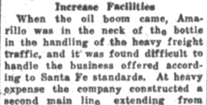
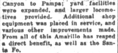
Right: Looking back on Santa Fe's investment in
the Panhandle, the Amarillo Sunday
News-Globe of January 12, 1930 discussed the impact of the
region's oil boom on the railroad.
In 1910, oil and gas was
discovered in the Texas Panhandle. As the fields were developed,
significant volumes of heavy rail traffic moved through Amarillo, much
of it carried by Santa Fe. In the 1920s, Santa Fe
decided to install a second main track between Canyon and
Pampa to improve traffic flow through
Amarillo. Santa Fe installed interlockers to manage the transition
between single and double tracks at
both Canyon and Pampa. |
 |
 |
The track north into Canyon from Plainview and Lubbock intersected the
Amarillo - Farwell main line on the west edge of town at Lubbock Junction.
The simple east and west connections with the single-track P&SF main line
became more complex when Santa Fe laid the second main track between
Pampa and Canyon because the double track extended far enough west to include
Lubbock Junction. Santa Fe decided to use an interlocking plant to manage
the transition between the main line single and double track and to control
switches and signals associated with movements on and off of the Lubbock /
Plainview line. Although Canyon did not have a large yard, there may also have
been yard siding switches that were included among the interlocking's functions.
As RCT became aware of Santa Fe's
efforts to manage the tracks on the west side of Canyon,
its engineering staff inquired as to when they could expect to see the
interlocker plans. In a
letter dated October 12, 1927, P&SF responded to RCT stating
"...it was not our understanding that plans
should be filed with the Commission when an interlocking plant was constructed
merely for the purpose of handling trains in and out of a junction point and no
other railroad involved." RCT responded that
it had never interpreted its policy as having any restriction on its
authority to approve all interlockers. The precedent had already been set for
single-railroad yard interlocking plants to be approved by RCT with the
commissioning of
Tower 121
in 1925, but it was an actual tower structure
built to house the interlocker controls and operators. Since the system at
Canyon would be remote controlled with no tower structure,
RCT's response to Santa Fe
established that its approval policy was to be enforced for all interlocking plants
regardless of local or remote control, or whether a second railroad company was
involved. Shortly after RCT's
response, P&SF submitted the required documentation. Santa Fe's interlocker
at Canyon was then designated Tower 135 by RCT and authorized for operation on
December 9, 1927. It initially had 27 functions, a number indicative of the
complexity of the Lubbock Junction intersection and the
nearby transition between double track and single track.
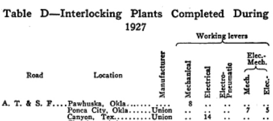 |
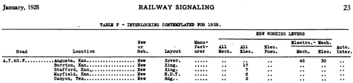
These two tables appeared in
the January, 1928 issue of Railway
Signaling. The table above
lists "Interlocking Contemplated for 1928" for Santa Fe. The last entry
in the list projects two new working levers (to be "All Elec.") for Canyon that
would support a "Sdg." (siding) layout. The table at
left shows that in
1927, an interlocking plant built by Union Switch & Signal had been
installed at Canyon with fourteen working levers controlling functions
electronically through the plant. This implies that the two new levers
projected for 1928 were in addition to those installed at Canyon in
1927. Although RCT lists Tower 135 with 27 initial functions, there is
not a one-to-one correspondence between working levers and functions. It
was common for the total function count to exceed the number of working
levers because paired functions (i.e. those with a fixed relationship)
could be controlled by the same lever. For example, a "Proceed" home
signal control might be paired on a working lever with a control to
disengage the associated derail. |
Tower 135's function count increased to 33 in 1928, presumably associated with
the additional "Interlocking Contemplated for 1928" reported by
Railway Signaling. The count remained at that
number through the final public report issued by RCT on December 31, 1930. The use of an electric interlocker
allowed the controls to be remoted to a facility, e.g. a yard office or depot,
for use by operators (and there were operators
-- automatic interlockers were not allowed in Texas until Tower
141 opened at Lubbock in 1931.) The controls might have been handled by
operators at Santa Fe's regional office in Amarillo; a remote control distance of ~ 20
miles was not unprecedented by the late 1920s.
Tower 135's approval was a significant event in the history of
RCT interlocker management. From this point on, all railroads were
officially on notice that all interlockers required RCT approval, regardless of
their purpose or whether other railroads were involved. RCT's rigid stance
suggests that the agency was trying
hard to justify its continued regulatory relevance. The Transportation Act of
1920 had given vast power to the Interstate Commerce Commission (ICC) to manage
every aspect of railroad operations. The ICC's jurisdiction covered routes and
mergers, but also specific signals and derails. It was ICC approval that railroads sought, even
for simple signal changes, and its rulings took precedence over RCT decisions in
the event of a conflict. Ultimately RCT extended its approval policy to include more
sophisticated control systems such as Centralized Traffic Control (CTC), but advances in
railroad signaling and management systems quickly surpassed the ability of
RCT's limited engineering staff to do any legitimate technical assessment.
RCT's regulatory power over the enormous Texas oil and gas industry was not
subject to Federal oversight, hence the oil and gas side of RCT had begun to
receive the bulk of its staff resources. With the
railroad side diminishing in importance, RCT ended oversight of interlockers in
the mid-1960s; the last to be numbered and approved was Tower 215 at
Bloomington c.1966.
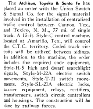
Right: (Railway
Age, April 10, 1948) In the late 1940s, Santa Fe
prepared to install CTC between Texico, NM
and Canyon. As noted in the news item, this was "77 mi. of single
track" establishing that the second main track installed into
Canyon in the mid 1920s had not been extended farther west. Instead, two
decades later Santa Fe decided to install CTC to improve operations on
the single track.
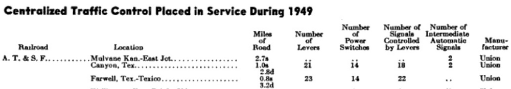
Below:
Railway Age, January 7, 1950
-- these short segments of CTC installed in 1949 probably represent the
integration of the new CTC with the double track present at both Canyon
and Farwell. The 's' and 'd' subscripts are for single and double track,
respectively.
The timing
of the CTC installation at Farwell tends to rule out the possibility
that this was the origin of Tower 188. The association of Tower 188 with
Farwell is assumed from the research performed by Southern Pacific
employee William J. Neill in the 1986-87 timeframe, but the source
material produced by that research has not been detailed. Tower 188
should have been installed in the early to mid 1940s based on the
installation timing for other known interlockers. |
 |
Assuming that Tower 188 was indeed an interlocker at Farwell, examining the
timing of other known interlocker commissioning dates tends to place Tower 188's
installation in the early 1940s. There's no guarantee that interlockers were
installed in their numerical order, but they did tend to fall within similar
date ranges. Complexity and local factors sometimes caused interlocker design
and construction to deviate, resulting in "out of order" installations. There
were special cases, but in general, an interlocker usually became operational
within 6 to 18 months of receiving a number assignment, placing its
commissioning date in the range with interlockers having nearby tower numbers.
The variance tended to fall significantly after 1930 because the
number of new interlockers was declining and virtually all of them were
automatic interlockers which did not require construction of 2-story manned
towers. A hearing was held by RCT on October 30, 1942 to approve the Tower 189
interlocker, so it is reasonable to assume that it was installed in 1943. This
would tend to place the commissioning date for Tower 188 in the 1942-1944
timeframe.
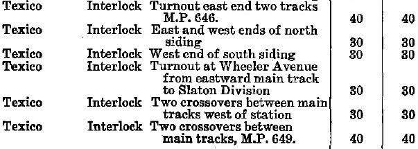
| Right:
This image is taken from Santa Fe's Plains Division employee timetable
dated April 2, 1950. It shows the Texico entries from a table of speed
limits to be followed when passing through switches and interlockings.
The table lists six interlocked locations at Texico with various speed
limits in miles per hour (for passenger and freight trains,
respectively.) The larger table has no Farwell entries; Santa Fe used
Texico as the common reference for operations at the state line,
regardless of which side. In particular, the first entry identifies an
interlocker at the "east end two tracks M.P. 646", a milepost located in
Farwell. The fourth entry indicates that the turnout from the east main
track to the Slaton Division (line to Lubbock) was interlocked at
Wheeler Ave., another name for U.S.
60 on the New Mexico side of the border. This Wheeler Ave. connection no
longer exists; the Lubbock line now extends west into New Mexico two
miles before connecting to the main track. |
 |
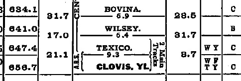 |
Left: This
image from the same timetable shows that Texico was located at
M.P. 647.4, hence M.P. 646 was 1.4 miles east of Texico, i.e. far enough
into Farwell to include the junction at the border with the Slaton
Division track to
Lubbock. This make sense; the same approach was used at Canyon to
include Lubbock Jct. within the interlocking. The interlocking affected
tracks in Texas hence there was jurisdiction for it to be incorporated
into RCT's interlocker management protocol as Tower
188 at Farwell. Whether the interlocking plant was located physically
within Texas is undetermined. It was most likely an automatic
interlocker, technology that had become common in Texas by the early
1940s. The timetable also notes "2 Main Tracks" between Texico and
Clovis. The second track likely precipitated the need for Tower 188. |
Virtually identical information as above also appears in a Santa Fe timetable
dated June 2, 1946 which indicates that the double track between Farwell and
Clovis was in place by then. The information does not
appear in a Santa Fe timetable dated July 5, 1942, i.e. there was not yet a
second main track between Farwell and Clovis. A 1942 - 1946 timeframe for the
installation of the second main track aligns with the likely date of the Tower
188 installation based on its tower number. It is reasonable to assume that the
second main track was activated once the interlocking was in place to arbitrate
access to and from the single track to Canyon. As noted earlier, that single
track was outfitted with CTC in 1949. An article in
Railway Signaling from March, 1929 states that Santa Fe had placed an
order for "block signaling material" to be installed at various places
including "Canyon, Tex. to Fort Sumner, N.M., 146.4 miles single track".
Since Fort Sumner is sixty miles west of Clovis, this indicates that the plan at
that time was to continue with only a single track west of Canyon through
Clovis, at least as far as Fort Sumner.
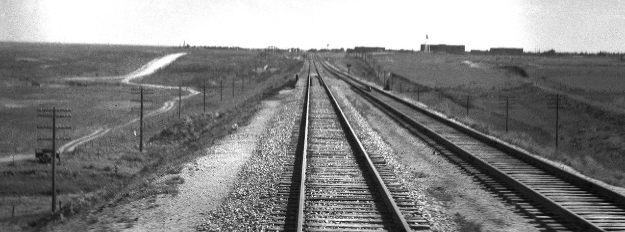
Above: John W.
Barriger III took this photo from the rear platform of his business car as his
train proceeded north out of Canyon toward Amarillo. The photo was taken on May
5, 1940 shortly after he took the photo that appears at the top of page. His
view is nearly due south toward Canyon, his train having completed the big curve
on the east side of town about three quarters of a mile distant from Barriger's
vantage point. The curve sent the tracks north toward Amarillo instead of
continuing northeast to Washburn on the original P&NT survey. Barriger's
location is known with some precision because his car has just passed over Palo
Duro Creek on the bridge in the foreground. The large size of the buildings in
the distance and the elevated terrain in that direction makes them appear closer
than they really are. They comprise part of West Texas State Teachers College,
the new name applied in 1923 to what had been West Texas State Normal College
when it opened in 1910. (It is now known as West Texas A&M University.) Per historic aerial imagery, the tracks have passed on this
side (north) of all of the University's buildings since at least since 1953, and this was probably
also true in
1940.
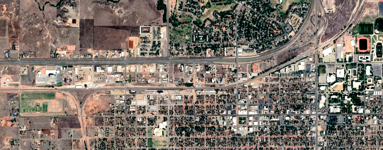
Below:
This recent Google Earth satellite image of Canyon shows a track layout
through town that remains essentially unchanged since 1906. The wye that forms Lubbock
Junction is prominent on the west (left) side of town, with the BNSF main line
passing due east / west through it. Closer to downtown, the track adjusts to a
slight northeast heading and then begins the large curve to the north toward
Amarillo. The university's sports complex consisting of a football stadium,
practice fields, a soccer stadium and a baseball stadium are visible in the
upper right corner.
Below: These aerial / satellite images of Texico show
that the original ROW continued straight southwest toward Portales on the same
general heading as the P&NT main line from Canyon. The prominent visibility
in 1954 ((c)historicaerials.com) of the original grades suggests that after the
curve onto the Belen Cutoff was built in 1908, some of the original tracks in
Texico may have been retained as a small yard or perhaps simply a wye. If there was still a main line connection
in 1954, it
is difficult to see. Portions of the original grades remain visible on Google
Earth satellite imgery in 2022, but there is no trace of them to the southwest
between Texico and where the tracks on the original ROW resume.