Texas Railroad History - Tower 143 - Devers
Crossing of the Texas & New Orleans Railroad and the
Robertson-McDonald Lumber Company
 |
Left: This
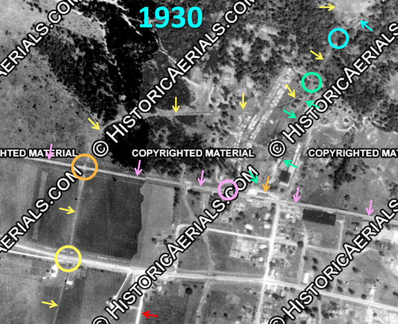
aerial image ((c) historicaerials.com) from 1930 has been annotated to
show the routes of the Texas & New Orleans (T&NO) Railroad (pink arrows)
and the Robertson - McDonald Lumber Co. tram (yellow arrows) at Devers.
Their crossing (orange circle) was noted (below
left) in a 1926 T&NO Employee Timetable (ETT) as 1,763
ft. west of the T&NO passenger station (orange arrow.) It was controlled
by a "temporary interlocker" that was eventually assigned a number,
Tower 143. A switch (pink circle) near the T&NO station led to a mill
spur (green arrows) that continued north to a switch (green circle) that
connected with the main tram line. Farther north, a switch (blue circle)
provided for a second tram route into the forest. Those tram
rights-of-way (ROWs) are now Frost Road (yellow arrow) and Stillmeadow
Lane. (blue arrow.)
South of Tower 143 (orange circle), the tram ROW is now Duff
Road. The tram crossing (yellow circle) of the main highway (now U.S.
90) appears
possibly grade separated, but that seems unlikely for 1930 and there's
no evidence of it now. Woodard Rd. (red arrow)
and the tram line eventually merged to a
common ROW farther south and crossed. They continued south with Woodard Rd.
directly beside (and west of) the tram. The tram line can be followed on 1930
imagery to a point 11 miles southwest of Devers in a forest near the Trinity River.
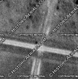
Left: The interlocker cabin
is known to have been located
in the northwest quadrant of the Tower 143 diamond. A dark spot is visible there
on the 1930 imagery, most likely a shadow of the cabin, consistent with what appear to be
westward shadows elsewhere on the image. |
Prior to the Civil War, the railroad that became the Texas & New Orleans (T&NO)
had been chartered by a lumber company for the purpose of connecting
southeast Texas with the port of Galveston. Three years
later in 1859, the T&NO name was adopted when the idea of a rail line between
Houston and New Orleans became popular. By 1860,
tracks had been laid between Houston and Orange via
Beaumont, and as the Civil War commenced, the T&NO
briefly became a military supply line. The tracks deteriorated quickly, and in
the post-war years, there was only intermittent service on short track segments
for brief periods. Eventually, the line was rehabilitated and reconstituted into
a new company under the T&NO name. The first post-war train between Houston and
Orange operated in November, 1876. In 1880, the T&NO commenced scheduled service
between Houston and New Orleans, providing a critical transportation service for
people and freight. It was also immensely helpful in the development of the
lumber industry in Texas and Louisiana because the railroad could distribute
wood products produced by sawmills along its route. The T&NO was acquired by
Southern Pacific (SP) in 1881 to be part of a southern transcontinental route between
California and New Orleans that became known as the Sunset Route. As SP
acquired other railroads in Texas and Louisiana over the next four decades, it
eventually decided to
make the T&NO its primary operating company for SP lines in Texas and Louisiana. In
1927, these other SP-owned railroads were leased by the T&NO and then merged into
the company in
1934.
The settlement of Dever's Woods was one of the many communities along the T&NO tracks
between Houston and Beaumont. It had existed since
1832, became incorporated in 1872, and by 1874 had a train station and a US
Post Office. The name was shortened to Devers in 1892. A series of canals fed by
tributaries of the Trinity River were constructed in the area to support rice
farming, and there was also accessible forest land nearby holding millions of
feet of timber. The first to enter the lumber business at Devers was Stewart
Liken in 1888. The location of his mill is undetermined, but he is known to have
operated a 6-mile narrow gauge tram to access the forest. His efforts appear to
have terminated in 1893 and his death at Devers was recorded on October 27,
1895.
The next mill known to have operated at Devers was the Robertson-McDonald Lumber Co.
in the early 1920s. The company had been organized and based in Houston in 1916 by
C. J. Robertson and Roy McDonald, but precisely when the Devers mill was built is undetermined. According to a
1926 biography of Robertson (hat tip,
Texas Transportation Archive) published in the New
Encylocpedia of Texas (Texas Development Bureau, Dallas, 1926)...
The Robertson- MacDonald Lumber
Company have a saw mill at Devers, Texas and saw fifty thousand feet of lumber
daily. They also sell pine and hard-wood lumber at wholesale throughout the
United States. They specialize in oil field lumber and have lumber yards at West
Columbia, Goose Creek and Houston. Besides the number of people employed at
their several lumber yards, two hundred are in the saw mill organization.
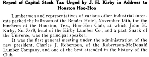
Above:
The November, 1925 issue of Western
Lumberman mentioned C. J. Robertson being the new president
of the Hoo Hoo Club in Houston. The
International Concatenated Order of Hoo Hoo is a lumbermen's
fraternal organization (Hoo Hoo being a slang term for "lumberman") still
active with chapters throughout the U.S. The article does not state
whether Robertson was ever named a
Snark of the Universe.
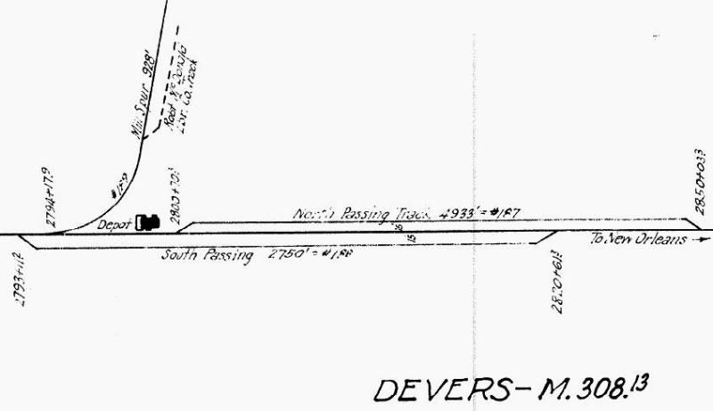
Right: The sawmill and the passenger depot were
on the north side of the T&NO tracks at Devers. This 1926 track chart
(Carl Codney collection) shows that the Mill Spur into the sawmill at
Devers ran north from the T&NO tracks for 928 ft. A company track is
shown connecting to the spur and there were likely other storage tracks
not shown. The tram crossed the T&NO about a third of a mile west of the
depot.
|
 |
Sometime in the late 1920s, Robertson started the
Robertson - Kurth Lumber Company with his friend Ernest L. Kurth, owner
of the Angelina County Lumber Company founded by his father Joseph
Kurth, Sr. near Lufkin in 1890. Kurth
also owned a mill in Liberty County along the Trinity River that became part of
the new company, as did the mill at Devers (under lease.) According to the Texas
Forestry Museum Sawmill Database...
Gulf Coast Lumberman
reported in February, 1931, that the Robertson-McDonald sawmills at Devers and
Liberty were running again. Sometime in 1934 or shortly thereafter, C. J.
Robertson and E. L. Kurth took over the mill's operation at Devers. Before
January, 1936, Robertson-Kurth sold machinery from the Devers operation to a
company that built a hardwood mill in Mexico, all of which effectively shut down
the operation in Devers."
It is not clear from this citation whether Robertson -
McDonald Lumber Co. also had a mill near Liberty, or whether the mill at Liberty
was Kurth's mill that had become part of the Robertson - Kurth operation. The
passage says running again, implying that one or both of these mills
had been shut down in the 1920s. It also says that Robertson and Kurth "took
over the mill's operation at Devers" possibly implying that Robertson had
leased it to someone else in the late 1920s or early 1930s. Alternatively, the
reference might simply have been to distingush Kurth from McDonald as
Robertson's partner at Devers. Regardless, it is apparent that the
Devers mill stopped operating c.1935. The town of Liberty is twelve miles west
of Devers, and the Trinity River passes through the area immediately west of
town. The location of the Liberty mill is undetermined, but a tram line from the
sawmill at Devers can be followed on 1930 aerial imagery to a point very close
to the Trinity River eleven miles southwest of Devers. This location would be
about twelve miles southeast of Liberty, but whether this tram line from Devers
also served a mill
near the Trinity River is undetermined.
In 1901, the Railroad Commission of Texas (RCT) was given responsibility for
mandating and approving safety measures for railroad crossings at grade. RCT
ordered swing gates implemented at all crossings and then began to require
interlocking plants at specific crossings. RCT created a numbering system for
interlockers beginning with Tower 1 in Bowie in
1902. The first interlocked crossing that
involved a lumber tram was Tower 111 at Trinity in
1919. Such trams were numerous in east Texas and for many years, tram crossings
had been completely uncontrolled. How did the railroads and logging companies
evade the 1901 law granting RCT authority to regulate grade crossings? The law applied "when one
railroad seeks to cross the tracks of another railroad company", but
logging companies were not railroads! [This began to change when the conversion
of tram lines into tap lines started
during the first decade of the 1900s.] The railroads eventually decided it was to
their benefit to secure these tram crossings and they began relying on swing gates
and restricted speeds to provide a modicum of operational safety. The trams had
no choice but to cooperate; they did not have state railroad charters, hence
they had no means to force a railroad to allow them to install a crossing. When
railroads decided to interlock tram crossings, RCT got involved, asserting
authority to approve all interlockings on Texas
rail lines, regardless of the circumstances.

Above: The January, 1923
edition of Railway Signal Engineer
included this table of planned interlockings to be installed or updated in 1923.
Devers is listed under S.P. Texas & Louisiana Lines as a "cabin type"
interlocker with a 3-lever mechanical plant.
The interlocker at Devers
was authorized for operation by RCT as a mechanical cabin interlocker on April 5, 1923.
Mechanical levers were mounted in the cabin; tram personnel would enter the
cabin to use the levers to set the main line signals so that oncoming T&NO
trains would be warned that the diamond was occupied by a crossing tram. When the
tram had finished passing over the diamond, the crewmember would reset the
signals to allow unrestricted movements on the T&NO. Documents in the RCT's interlocker archives preserved at DeGolyer Library, Southern Methodist University
show the cabin in the northwest quadrant of a nearly right-angle crossing
(87 degrees.) The interlocking plan was drawn in December, 1921, then further revised in August
and November, 1922 as the interlocker construction was being completed. The
DeGolyer files show that RCT considered the Devers interlocking to be a
"temporary plant".
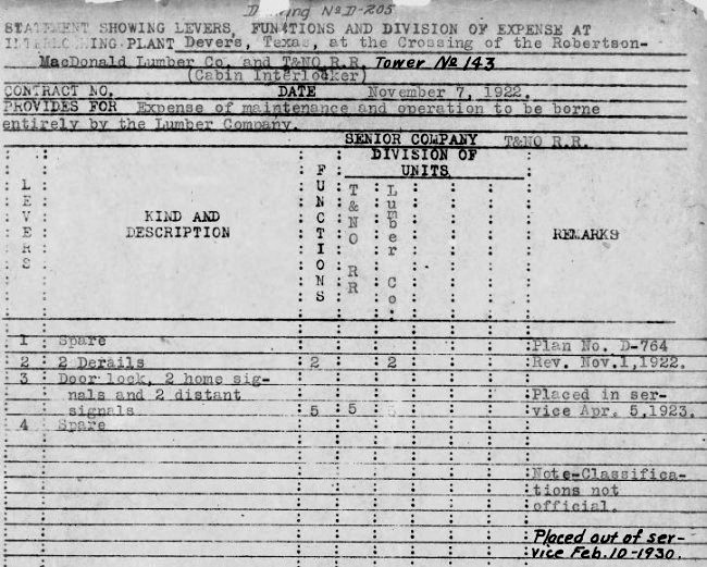 |
Left: SP used
an internal form titled Drawing D-205
as a means of summarily documenting each interlocking with which it was
involved. The D-205 for Tower 143 (Carl Codney collection) provides
significant details regarding the development of the interlocker at
Devers. It notes that the contract between the T&NO and the
lumber company was dated November 7, 1922 and that the
"Expense of maintenance and operation to be borne entirely by the Lumber
Company."
It is identified as a cabin interlocker; a tram crewmember would enter the cabin to adjust the
levers for passage before and after each crossing, hence there was no
separately-expensed labor. The only other operational expense would have
been electric utility power if it was needed.
The document shows
that all of the functions assigned to the T&NO were on Lever 3.
Surprisingly, this did not include
derails, whereas derails in both directions was the only function
assgned to the lumber company (on Lever 2.) Trams did not need to be warned
whether the crossing was occupied, thus the line had no distant signals.
Every tram stopped at the crossing to
have a crewmember enter the cabin; a fixed sign was sufficient to warn
the tram that it was nearing crossing. The tram did not need home
signals; it would proceed across the diamond when the interlocker signalled to
the crewmember in the cabin that the T&NO distant signals had been activated
and that there were no nearby T&NO trains.
The handwritten notes
on the document are particularly significant. "Tower 143" was added at
some later date after the document was produced, whereas in most cases, the tower number
was typewritten into the D-205 drawing when it was initially prepared
(e.g. Tower 2,
Tower 7, Tower 39 and several others.)
Another handwritten note identifies February 10, 1930 as the day the
interlocker was taken out of service. |
Documents in the DeGolyer files indicate that the Tower 143 interlocker design was
in work in 1921-22, yet its 1923 commissioning date is not aligned with the
dates for other towers with similar numbers. The only two tower numbers assigned during
1923 were Tower 113 and Tower 114,
whereas Tower 143 should be in the range of commissioning dates for Tower 144
(May, 1928) and Tower 145 (January, 1929.) [It is also in the range of
Towers 141 and 142, but these were special cases --
the first automatic interlockers in Texas -- whose commissionings were delayed
until 1931.]
The reason Tower 143 was commissioned before it was assigned a
tower number is that RCT considered it a temporary plant. While RCT's precise
regulations for temporary plants have not been uncovered, they presumably
included some sort of limited anticipated operational duration consistent with
the expectations for tram crossings. Such crossings were assumed to be temporary since the
forests accessible via the crossing would likely be cut out by the lumber
company within two or three years after which the crossing would no longer be
needed. It is clear that RCT didn't assign a tower number to their Devers file
until 1928. Perhaps RCT didn't realize that the Devers plant had exceeded
its expected temporary lifespan until they were informed in 1928 by T&NO that
the interlocker was still in service. This appears to have occurred when T&NO
notified RCT that they were anticipating the interlocker could soon be removed.
RCT replied to T&NO on June 8, 1928 with a letter stating..."When it is
ready to be taken out, the Commission will gladly give authority." Through
the end of 1930, RCT published an annual list of active interlocking plants.
Tower 143 first appears in the list dated December 31, 1928, but is shown
with a commissioning date of April 5, 1923. Tower 143 also appears in RCT's final
comprehensive list dated December 31, 1930 although it had been taken out of
service nearly eleven months earlier.
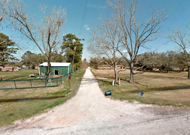
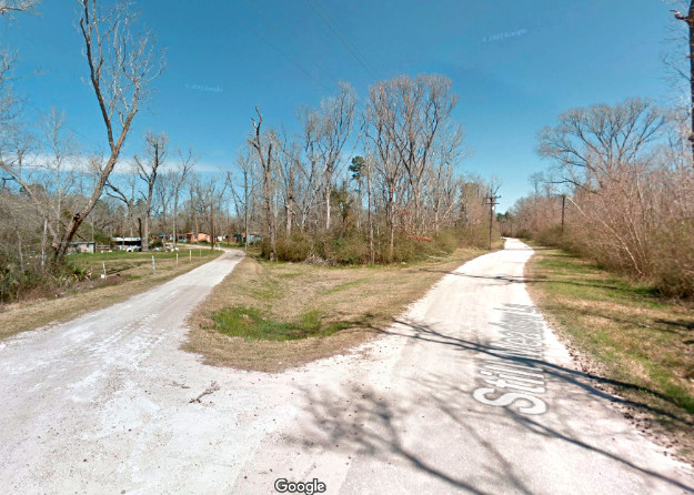
Above
Left: Looking north from U.S. 90, Duff Rd. is the former
tram ROW. The T&NO tracks pass just beyond the end of the road in the
distance. Duff Rd. does not continue south of U.S. 90 as the tram once
did, and there is no apparent evidence of the tram ROW south of the
highway. (Google
Maps, 2013)
Above Right:
North of the mill, the tram line split into two routes proceeding
farther north into the forest. Today those ROWs are occupied by Frost
Road (left) and Stillmeadow Lane (right.) (Google Maps, 2013)
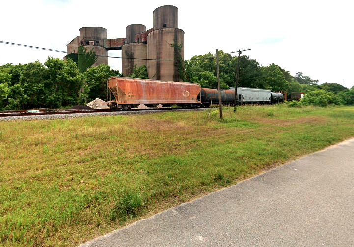
Right: The T&NO
station at Devers sat trackside where this field now sits. The view is
southwest from Sawmill Rd. Tower 143 was a third of a mile to the right.
(Google Maps, 2023) |
 |


