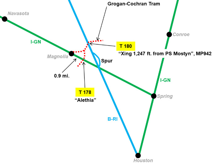
Texas Railroad History - Tower 178 (Magnolia) and
Tower 180 (B-RI Milepost 95.2)
Two Grogan-Cochran Lumber Company Tram Crossings
of Class 1 Railroads Near Magnolia
 |
Left:
This map shows rail lines (c.1934) in the vicinity of Magnolia, a small
town in Montgomery County northwest of Houston. Railroad Commission of
Texas (RCT) records list two interlockers, Towers 178 and 180,
associated with a Grogan - Cochran Lumber Co. tram line in this area.
Documents in the RCT archives maintained at Southern Methodist
University's DeGolyer Library reference Tower 178's location generally
as "Magnolia", but it was actually 0.9 miles southeast of town at a
location called Alethia where the tram crossed the International - Great
Northern (I-GN) Railroad. Alethia was the site of a Lone Star Lumber Co.
mill; Lone Star merged with Grogan-Cochran in 1927.
The Tower 178 interlocker was
placed in service on July 8, 1932 and included a "crossing gate and
derail" according to documents at DeGolyer. The simple 2-lever
mechanical plant set or cleared
the signals and derails in conjunction with the gate opening or closing,
but it is unclear how the gate was connected to the interlocker. The
gate's position needed to be incorporated into the interlocker's
mechanism, perhaps sensed from the gate latch, so that a PROCEED signal
to an approaching I-GN train would be withheld if the gate remained
positioned against the I-GN when the levers were reset to grant
unrestricted movements on the I-GN. A decommissioning notice in 1940
states that there were home and distant signals on the I-GN, and derails
on the tram line.
The Tower 180 file at DeGolyer Library documents a
cabin interlocker placed in service on February 23, 1934 at a location
recorded as "Milepost 95.2 on the B-RI", the only tower RCT identified
by a milepost designation. This was on the Burlington-Rock
Island (B-RI) Railroad which passed through Mostyn a few miles east
of Magnolia. Although RCT officially referenced milepost 95.2, a map in
the Tower 180 file shows it as "MP942" (milepost 94.2) with a notation "Xing 1,247 feet from PS Mostyn", a passing siding known to have existed at Mostyn. |
Magnolia obtained rail service in 1902 when the
International & Great Northern (I&GN) Railroad laid 78 miles of track from
Bryan to Spring via
Navasota. Spring was on the I&GN main line in the northern outskirts of
Houston. The construction was part of a larger effort by the I&GN to build a
rail line between Fort Worth and Houston. The I&GN went into
bankruptcy in 1914 and emerged from
it on July 28, 1922 as a newly reorganized and independent company under
the name International - Great Northern Railroad (hence I-GN
is the appropriate abbreviation post-1922.) In 1925, Missouri Pacific (MP)
acquired the I-GN, which continued to operate under its own name until it was
merged in 1956.
In 1905, the
Trinity & Brazos Valley (T&BV) Railway was acquired by the Colorado & Southern (C&S)
Railway, which immediately sold half-interest to the Chicago, Rock Island & Pacific Railway.
The T&BV had been chartered to build from Cleburne
through Mexia and onward to
Beaumont. Instead, the C&S / Rock Island partnership
led by native Texan B. F. Yoakum saw the T&BV's Texas railroad charter as a
valuable component of their plan to build a major rail line connecting
Dallas and Fort Worth
with Houston. T&BV construction led by Yoakum resulted in a rail line between
Teague and Houston that passed four miles east of Magnolia in 1906. There, the
T&BV founded the community of Mostyn and opened a station. Mostyn obtained a
post office in 1908, but it was closed ten years later.
In 1914, the T&BV went into a lengthy receivership which ended
in 1930 with the founding of the Burlington - Rock Island (B-RI) Railroad.
B-RI took over the assets of the T&BV and was owned equally by its two parent
railroads, Rock Island and the Chicago, Burlington & Quincy (CB&Q).
CB&Q had acquired the C&S in 1908. Rock Island and CB&Q operated the B-RI in alternating 5-year intervals,
with CB&Q designating the
Fort Worth and Denver (FW&D) Railway (acquired in the C&S purchase)
as its operating railroad for the B-RI.
Decades later, the CB&Q merged with two other railroads in 1970 to form Burlington Northern
(BN.) By then, the B-RI had been dissolved (in 1964) by its owners --
the separate B-RI corporate entity had long ceased to provide any value -- and each
owner gained unlimited rights to use the B-RI tracks in exchange for an equal share
of maintenance expenses. When Rock Island went bankrupt in 1980, BN became the
sole owner and the tracks were assigned to the FW&D. Two years later, BN
fully merged
the FW&D.
In 1912, the Grogan brothers formed a lumber
company at Gladstell in Liberty County. Lumber companies relocated frequently as areas cut out and new timber
leases were acquired, so by 1917, the company was operating near Grand Lake,
southwest of Conroe in Montgomery County. At that time,
it became re-incorporated
as the Grogan-Cochran Lumber Company. By the late 1920s, Grogan-Cochran had major
land-holdings and operations across Montgomery County (by one estimate, 25 mills in
the county.) In 1927, Grogan-Cochran merged with Lone Star Lumber Co., but retained the Grogan-Cochran name.
Over many years, the company laid miles of tram lines across its vast
landholdings in Montgomery County and elsewhere to facilitate moving logs to its mills.
Development of The Woodlands, a well-known suburban community and commercial
center north of Houston, began with Grogan-Cochran's sale of 50,000 acres to
developer George Mitchell in 1964.
It was not uncommon for lumber trams to need to
cross Class 1 (major) rail
lines. Numerous tram lines were present in east Texas and for many years, such crossings were
completely uncontrolled. How did the railroads and logging companies evade the
1901 law granting RCT authority to regulate crossing safety? The law applied "when
one railroad seeks to cross the tracks of another railroad company", but
logging companies were not railroads! As trains became longer and faster (and
thus required greater distance to stop in an emergency) railroads decided it was to
their benefit to secure these crossings. The trams had
no choice but to cooperate; they did not have state railroad charters, hence
they had no means to force a railroad to allow them to cross a rail line.
Initially swing gates and restricted speeds provided a modicum of
operational safety, but the idea of interlocking these crossings began to take hold. RCT got involved to
re-assert its claim of authority to approve all interlockers on
Texas rail lines regardless of the circumstances. Tower 111
at Trinity was the first interlocking plant commissioned by RCT that
involved an actual logging tram. The Trinity interlocking had been
preceded by Tower 110 at Dayton, but the
Dayton crossing involved a tap line, not a tram line, an
important distinction.
Right:
This drawing reproduces a sketch made at DeGolyer Library during review
of a map found in the Tower 180 file. Though MP was not involved with
Tower 180, the file contains a letter dated February 1, 1934 from MP to RCT
(apparently in response to some inquiry) stating "The tram line shown is
the same one that crosses our Ft. Worth line at Magnolia." MP's
crossing, however, was not "at Magnolia"; it was adjacent to the
Grogan-Cochran mill in the tiny community of Alethia
southeast of Magnolia. The
DeGolyer files mention that Tower 180 was a cabin interlocker, whereas the
only details provided for Tower 178 are "crossing gate and derail". Note that the
crossing of the two Class 1 railroads in the center
of the diagram was (and remains) grade-separated. |
 |
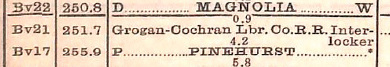
Above: Though RCT only
used "Magnolia" as its official location for Tower 178, an October 30, 1932
Employee Timetable (ETT) issued by MP provides information from which
the precise location of Tower 178 at Alethia can be discerned. The snippet at left
shows that the difference in the "Distance From Fort Worth" column
(251.7 - 250.8) places the interlocker 0.9 miles south of Magnolia
(specifically, south of the I-GN station at Magnolia known to be near
the town center.) "BV21" is the
identifier of the station nearest the crossing. The
center image is taken from a table listing all crossings
and their mode of protection. It identifies "21.1" as the milepost for
the Grogan-Cochran tram crossing (measured northward from Spring.) To the right of the milepost number, the next two columns
are labeled
Other Railroad (Grogan-Cochran Lbr. Co.) and Senior Line
(I-GN). The
rightmost column specifies how the crossing was controlled, if at all. Here, the
tram crossing is listed as "Interlocked", but there were also crossings in the
table listed as "Gated", "Not Gated" and "Automatic Interlocker". [The
aforementioned interlocker at Trinity was the only one listed as "Automatic
Interlocker".] The snippet at right
is taken from a table titled "Business Tracks Not Shown As Stations On Time
Table". In the table, Alethia corresponds to station "BV21" identified (at
left) as the station nearest the tram
crossing. The table also lists the business track for Alethia at
milepost 20.5, about 0.6 miles south of the interlocker.
Below: The January,
1933 edition of Railway Signaling
and Communications published a table titled "Interlocking
Plants Completed During 1932." The "2 2" entry for the
I-GN at Magnolia indicates that the interlocker had two levers, and that both levers were
mechanical. These levers controlled the signals and derail(s) through the
interlocker, which most likely sensed the gate
latch (open or closed) as part of its logic, i.e. an unlatched gate
could be assumed to be positioned against the I-GN. There's no mention
of a cabin at Tower 178, so this was probably a "ground lever"
interlocker, i.e. two levers mounted to a pedestal adjacent to the
crossing, similar to Tower 182.
 |
|
Right: The
August, 1940 issue of Railway Signaling
and Communications carried this news item regarding the
removal of the Alethia interlocking. In particular, note the "removal of crossing gate and derails on the
lumber road, and home and approach signals on I-GN". A document at DeGolyer Library
refers to a "crossing gate and derail" for Tower 178, but provides no
further information. In 1930, RCT had discontinued the requirement to employ derails
with new interlockers, at least in the context of automatic interlocking plants at
Plainview and Lubbock. Derails had proven to cause more problems than they
prevented. If so, why have derails on the tram line? Although the news
item used "derails" plural, it might have been a single derail, consistent with the
notation in the DeGolyer document. If so, it was likely placed on the mill (west) side
of the diamond where it could protect against loose lumber cars rolling uncontrolled out of the
mill yard and across the I-GN main line. This was (and still is) a
common feature for industry spurs. Such derail might have been appropriate for the mill tracks at Alethia, depending on
the track topology and their proximity to the I-GN. A tram derail east
of the diamond might have been omitted since all
inbound trams stopped at the crossing anyway to change the interlocker
controls to allow passage across the I-GN tracks. |
 |
Unlike the location of Tower 178, determining the
precise location of Tower 180 presents a substantially greater challenge. RCT
referenced it at both milepost 95.2 and milepost 94.2 on the B-RI. Fortunately, the crossing is cited in ETT's issued by B-RI in 1937 (on March
14 and
August 29) as being located at "Mile Post 95.34". Unfortunately,
B-RI failed to precisely define its milepost convention, using instead a
misleading "Distance from Galveston" column in its station list. Sometime after
its June 5, 1938 ETT (in which the tram crossing was no longer listed) B-RI reverted to providing the actual milepost numbers in
the station list. They are present in the ETT dated November 2,
1941, long after Tower 180 had been removed.
How can it be established that the
mileposts in the 1941 ETT had been in use when the 1937
ETTs were issued? Might the 1941 ETT have used a new re-numbering of
mileposts? No. A 1919 T&BV ETT includes mileposts in the station list, and they
match the mileposts in the 1941 ETT. Mileposts were not present in B-RI's first
ETT issued June 1, 1931, replaced by the misleading "Distance from Galveston"
notwithstanding that there were more than a dozen actual milepost references in
a table of "Business Tracks". Failing to include mileposts in the 1931 ETT's station
list meant that the locations of those business tracks could not be correlated
directly with the station locations. B-RI persisted with this confused policy at
least through the 1938 ETT.
 |
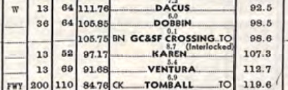
Left:
B-RI's 1937 ETTs locate the interlocker for the Grogan-Cochran tram
crossing at "M. P. 95.34" in a table of railroad crossings, noting "Hand
Operated Signals; No Derails". But the
crossing is not present in the list of stations (right) unlike Tower 70 near Dobbin, which
is listed and noted as an interlocked
crossing. |

Above:
The columns adjacent to the station names in the 1937 ETTs are distances from
Galveston
(left) and Teague (right.) The station list does not specify
mileposts. |
It is hypothetically possible that B-RI was indeed
using "Distance from Galveston" as the "real" milepost numbers from 1931 through
1938, but this seems profoundly implausible. It would have been strange enough
for B-RI to have changed the T&BV's milepost definitions for no apparent reason
in 1931, but it would be doubly strange to then revert back to them in 1941. The
conclusion is that the official milepost numbers never changed, even if they
were not provided in the station lists in the 1930s ETTs. Thus, the location of
Tower 180 at "M. P. 95.34" should be judged by the milepost numbers in the 1919
and 1941 ETTs (which, by no coincidence, are still in use today.)
 |
Left:
The B-RI ETT issued November 2, 1941 continued to list "Distance From
Teague" in the column to the right of the names in the station
list, but the column to the left was changed to "Mile
Post". Compared to the "Distance From Galveston" that previously appeared
in that column, the differences are stark, e.g. Karen's official milepost is
3.03 miles farther south than its distance to Galveston in the 1937 ETT
(100.2 - 97.17.) The tram crossing at milepost 95.34
continued to lay
between Karen and Ventura, but moved three miles closer to Karen! Mostyn is not listed, but
it appears in T&BV's 1919 ETT at milepost 93.9. B-RI listed a business track
at Mostyn in the 1931
ETT at milepost 94.9. This one mile difference
between Mostyn (business track) and Mostyn (station) might explain why RCT
mistakenly used both 95.2 and 94.2 in documenting the location of Tower
180. |
|
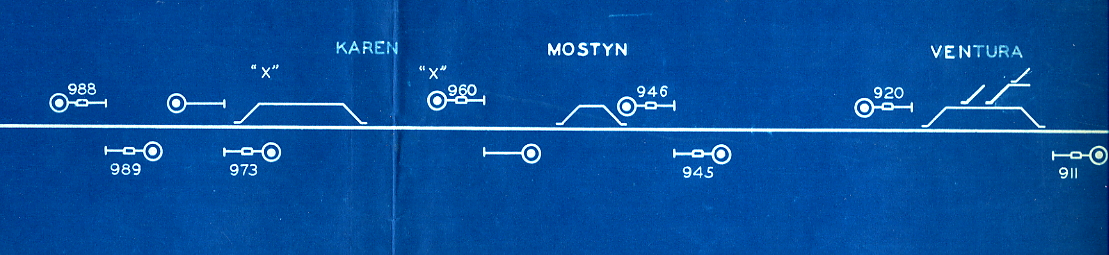
Below:
South is to the right in this 1952 track chart supplied by Tom Kline. The
numbers are mileposts with decimal points removed. Milepost 95.34 places the
tram crossing at
Tower 180 a bit north of the Mostyn siding, for which
the south switch signal was located at milepost 94.6. |
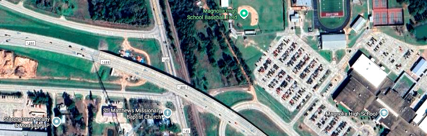
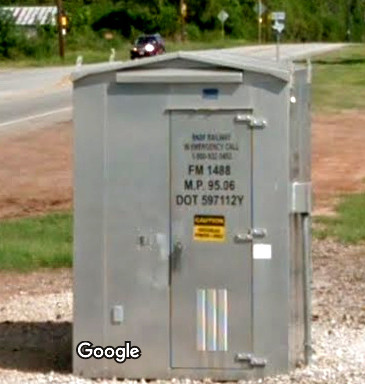
Right: When this Google Street View image was
captured in Sept. 2013, Farm Road 1488 crossed the former B-RI tracks at
grade at the center of the community of Mostyn, adjacent to the
intersection with Farm Road 149. This equipment cabinet sat barely north
of FM 1488 on the west side of the tracks and clearly identified the
local milepost as 95.06. Tower 180 would have been (95.34 - 95.06) =
0.28 miles (approximately 1,478 ft.) north of this location. Below: Today,
FM 1488 is a freeway that crosses over FM 149 and the former B-RI tracks.
The grade crossing and equipment cabinet at right no longer
exist. (Google Maps)
 |
 |
The DeGolyer files identify Tower 180 as a cabin
interlocker. These were used in situations where a lightly used line (the tram)
crossed a busy line (the I-GN.) Tower 180 could not justify a manned tower; the
operators would have had virtually nothing to do. They simply would have left the signals lined for the
I-GN at all times and reversed them only a handful of times per week when a tram needed to cross.
Instead, the Tower 180 interlocker and its controls were installed in a cabin,
basically a
trackside hut. Trams would always stop at the crossing and a crewmember would
enter the cabin to reverse the signals, allowing his tram to cross. Once safely
across the diamond, the crewmember would reset the signals to grant unrestricted
movements on the I-GN.
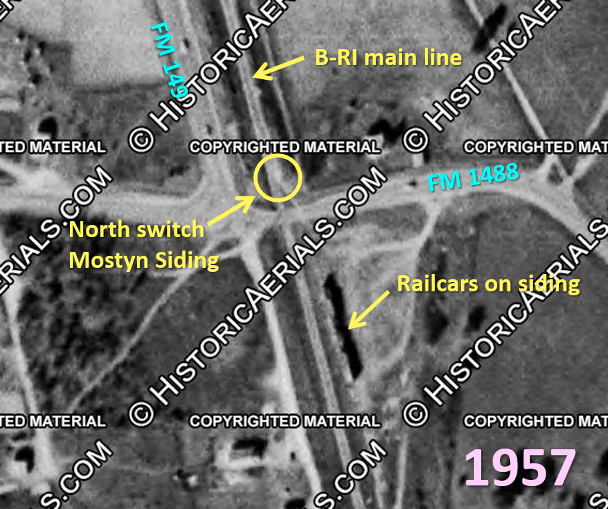
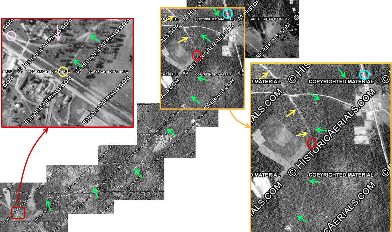
Above Left: Historical aerial imagery from 1957 ((c)
HistoricAerials.com) helps to solve the problem of locating Tower 180. This
annotated image shows railcars parked on Mostyn siding beside the B-RI main
line. The image reveals (yellow circle) the approximate location of the north
siding switch for Mostyn Siding at
latitude 31 13 41.4 N, longitude 95 41 29.8 W.
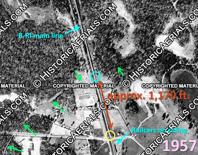
Above Right: A larger view of the same 1957 imagery
shows the remnant of the long abandoned Grogan-Cochran lumber tram (green
arrows) crossing the B-RI main line (blue circle) north of Mostyn at latitude 30 13 52.6 N, longitude 95 41 33.1
W. The distance from the crossing (blue circle) to the north switch at Mostyn
Siding (yellow circle) measures approximately 1,170 ft. using the distance tool
on Google Earth. Recall that a note in the DeGolyer Library file for Tower 180
finds the "Xing 1,247 feet from PS Mostyn". Assuming that "from PS Mostyn" means
north from the north siding switch, the measured distance of 1,170 ft. entails a discrepancy of
77 feet (0.0146 miles) certainly within the margin of error
given the imprecision of the location estimates from the imagery and the time
difference (i.e. 1957 was about twenty years
after the tram was operational; if the north siding switch moved during that period,
it was probably to lengthen the siding, reducing the distance to Tower 180.)
 |
Left: Aerial
imagery from 1956 clearly shows a white rectangle adjacent to the B-RI
tracks precisely at the crossing point suggested by the 1957 imagery above. The
rectangle is very likely the roof of the Tower 180 cabin mentioned in
the DeGolyer files. It was not uncommon for
railroads to leave cabins in place for many years (in this case, ~ 18
years) after an interlocker had been decommissioned (e.g.
Tower 213, still standing 34 years after
abandonment;
Tower 179, still standing after 46 years.) |
The last riddle to solve is ... can the identified
right-of-way (green arrows, above right) be proven to have belonged to the
Grogan-Cochran Lumber Co.? The solution has become available with aerial imagery
from 1930 released in recent years. The entire tram line can be
followed from the Tower 178 crossing at Alethia to the Tower 180 crossing north
of Mostyn. Since Alethia is known to have been the site of a Grogan-Cochran
mill, being able to follow the tram right-of-way all the way to Tower 180
confirms MP's letter ("The tram line shown is the same one that crosses our
Ft. Worth line at Magnolia.") and thus Grogan-Cochran's ownership of the crossing north of Mostyn.
Unfortunately, the 1930 imagery lacks sufficient detail to improve the location
estimate (above) for the north siding switch.
Below: This 1930 image ((c) HistoricAerials.com)
composition shows the
entire tram line from the Tower 178 crossing (yellow circle) at Alethia to the
Tower 180 crossing (blue circle) north of Mostyn. Magnification of Alethia (dark
red rectangle) shows that the tram not only crossed the MP main line (yellow
circle) at Tower 178, it also had a connecting track (pink arrow) leading to the
MP (pink circle), most likely to a siding rather than directly onto the MP main
line. The tram line (green arrows) proceeded from Alethia generally northeast
across the forest. Imagery near Mostyn (orange rectangle) shows that the line split (red circle) with the
primary line (yellow arrows) curving back to the northwest while a lesser-used
tram right-of-way continued north and east to cross the B-RI (blue circle) north
of Mostyn at Tower 180. This extension passing north of Mostyn is much easier to
see on 1950s imagery even though it had been abandoned for more than a dozen
years by then. The most likely explanation is that it was new in 1930, perhaps
still a grade waiting for rails, which might explain why Tower 180 was installed
eighteen months after Tower 178. If the tram was fully operational across both
Class 1 railroads at the time MP's decision was made to
interlock the crossing at Alethia, it seems plausible that B-RI would have been
aware of this and that they might have proceeded to interlock their crossing
also. Yet, there was an 18-month difference in the commissioning dates. The 1930
imagery and the 18-month delay suggest that the Tower 180 crossing may not have
been operational when the decision to interlock the Alethia crossing was made
(presumably in late 1931 or early 1932.)
A document in the DeGolyer Library file for Tower 178
states that it was decommissioned in June, 1940. The Tower 180 file does not
mention a decommissioning date, but B-RI's 1938 ETT no longer lists the
Grogan-Cochran tram in its table of railroad crossings.
While the
Grogan-Cochran tram line has disappeared into history, the two Class 1 rail
lines it crossed are very much alive. In 1982, MP was acquired by Union Pacific
(UP) which continues to operate a main line through Magnolia leading southeast to
major facilities at Spring. With Rock Island's bankruptcy, BN became the sole owner
of the former B-RI tracks in 1980. BN merged with the Atchison, Topeka & Santa
Fe Railway in 1995 to form BNSF, which continues to operate the tracks through
Mostyn. BNSF still uses B-RI's milepost numbering system with tiny
adjustments in various places (e.g. the Dobbin interlocker is milepost 105.6 per BNSF's
2010 Gulf Division Timetable; it was 105.75 in 1941.)
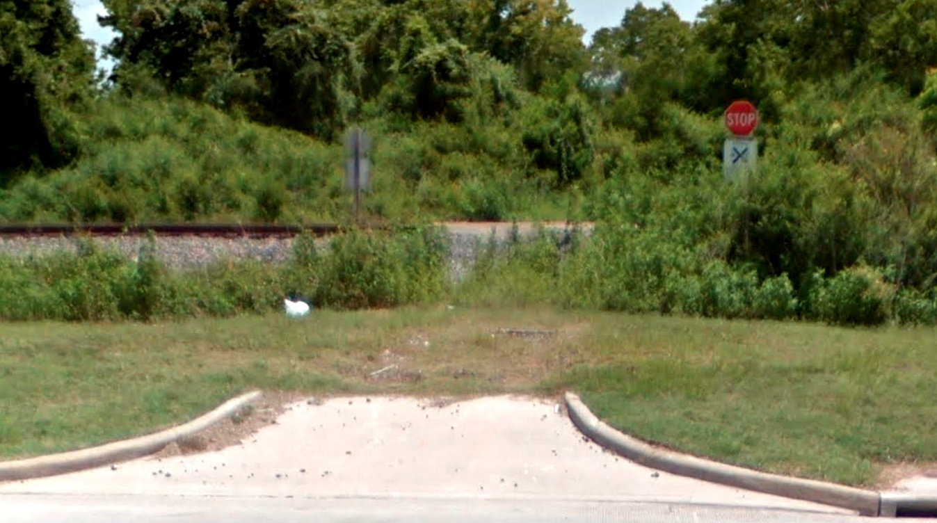 |
Left: This
Google Street View from July, 2018 looks east from Farm Road 1774 toward
UP's former I-GN tracks at the Tower 178 crossing site. The gate and
interlocker would have been visible in this view in the 1930s. It is
apparent from the curb and the stop signs that at some point, the
abandoned Grogan-Cochran tram right-of-way was used as a road into the
forest. Earlier Street Views (dating back to October, 2009) show a much
more obvious right-of-way continuing in the distance, but lack of use
caused foliage to obscure the path by 2018. The most recent Street View from
July, 2025 shows that the stop signs have been removed. Beyond the
trees, much of the land has been cleared in recent years for the
Magnolia Ridge residential subdivision. |