Texas Railroad History - Tower 91 - West Point
A Crossing of the Missouri, Kansas & Texas Railway and the
San Antonio & Aransas Pass Railway
 |
Left:
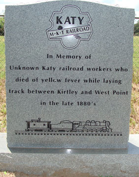
This marker stands in the Woods Prairie Cemetery near West Point memorializing
the Katy railroad workers who died of yellow fever in 1887 during construction
of the Missouri, Kansas & Texas (MK&T, "Katy") rail line between Taylor and La
Grange. This uncredited photo comes from an article in Footprints of
Fayette County by two railroad engineers, Larry Lutringer and
W. O. Wood, who write that the marker was...
...placed
there by Bobbie Robbins Stevens in 2013 and paid for by her mother, Susan Grace
Young Robbins. Susan had heard the story of the railroad workers all her life
and had helped her Aunt Molly (Mrs. Charles Young) tend the graves when she was
a child. It was Charles Young and his brother Zed (Bobbie Robbins Stevens'
grandfather) who gave the railroad foreman permission to bury the men in the
cemetery. The railroad workers who died earlier were buried in a field next to
the railroad tracks near Primm, which was later renamed Kirtley.
The yellow fever epidemic that killed the Katy railroad workers was small in
comparison to the one in nearby La Grange twenty years
earlier which
killed at least 20% of the town's population. The fatality rate was 90% for
those infected. The
New Orleans Crescent of September 26, 1867
carried a story describing the devastation one journalist saw in La
Grange...
"Those remaining of the citizens number barely 500 yet the interments have
reached as high as 24 in two days. ... Every house in the town is filled with
sickness and with death. Business has ceased entirely; the newspapers are no
longer published; the jail has been emptied of its inmates, who fled in terror
from the scene of desolation. In some cases there is no one to bury the
dead. Whole families have been swept away. ... The stores are all closed, and to
crown the misery of the unfortunate inhabitants, starvation is staring them in
the face. ...there were no provisions to be had in the town — not
even corn meal to make gruel with." |
According to Fayette County sources, West Point was
founded by William Young in 1840 and named after his hometown, West Point,
Mississippi. This was long before two railroads came through the area in 1887,
the first being the Taylor, Bastrop & Houston (TB&H) Railway. West Point's
location roughly midway between Smithville and La Grange placed it in the middle
of a TB&H track segment that was part of 79 miles
built between Taylor and La Grange that year. The tracks actually terminated eleven miles beyond
La Grange at Boggy Tank, a made-up name for the middle of nowhere. Why did construction stop? As was often the case for Texas railroads
in the post Civil War era, financial and legal issues halted the work.
The TB&H had come into existence because of Jay Gould, a notorious east coast rail baron,
who had begun to
expand his empire into Texas in 1879 through the Missouri Pacific (MP) Railroad
which he controlled. Gould was also President of the Missouri, Kansas & Texas (MK&T, "Katy") Railway
which had a multistate route network including tracks across the Red River into
Denison. The Katy was leased to MP,
and publicly, Gould made sure the new Katy construction he planned was reported in the press as MP activity. Track ownership, however,
would be titled to the Katy because MP was a
"foreign" railroad; it could not comply with Texas law requiring railroads in
Texas to be headquartered in state. It could, however, operate in Texas using a
Texas-based subsidiary or lease; the Katy lease served this purpose for Gould.
Ironically, the Katy was also a "foreign" railroad -- it had no Texas
railroad charter -- but it had been allowed by the Legislature to enter Texas in the early 1870s
under its Kansas charter for the purpose of bridging the Red River to connect
with the Houston & Texas Central (H&TC) Railway at Denison.
Gould figured that was enough to make it a "Texas railroad"; courts would later
disagree, but no one challenged Gould as he built new MP tracks in Texas under
Katy ownership. [Everyone wanted more railroads!] Gould's control of the Katy,
however, was tenuous -- he owned very little Katy stock and he had been elected
its President
by allies who had infiltrated its Board of
Directors over several years. The lease enabled Gould to transfer Katy profits to MP where he had
more substantial ownership. Accounting-wise, the Katy broke even at best, to
the detriment of its stockholders. Gould's plan was to lay tracks for MP under
Katy ownership from
Fort Worth to Houston by going south through
Waco and Temple before
eventually turning east through Smithville and LaGrange. By the end of 1882, MP
(Katy) tracks had reached Taylor, between Temple and Smithville.
The end of track remained at Taylor for a time due to the
political climate in the Texas Legislature. In 1882, it had repealed the land
grant law and lowered authorized passenger fares, and there were additional railroad
regulations under consideration. By 1886, Gould was ready to proceed
and he directed MP to resume construction south out of Taylor. It did so by
soliciting a state charter for the Bastrop & Taylor Railway headed
up by associates of Gould. Work commenced in
1887 under a revised name, the Taylor, Bastrop & Houston (TB&H) Railway. After passing
through Bastrop and crossing the Colorado River, the route took a southeast
heading into Smithville. From there, it went east through West Point and continued toward Houston via La Grange (where it would cross the Colorado River a second
time.) Once again, the TB&H activity was publicly deemed to be MP's effort, but
upon completion, the Katy would acquire the TB&H and own
the route for MP's benefit. At least... that was the plan.
By late 1887, financial issues
had begun to mount for Gould as one of his Midwest railroads went bankrupt.
Meanwhile, legal issues in Texas began in December when another Gould railroad,
the International & Great Northern, was sued by the Texas Attorney General
for failing to live up to its charter, exhibiting poor service and crumbling
infrastructure. Work on the TB&H stopped immediately, eleven miles
east of La Grange; the site was christened Boggy Tank.
By 1889, Gould's control of the Katy had collapsed; Katy stockholders summoned a quorum and fired
him in May, 1888, and Texas courts broke the lease to MP, finding it unlawful. In
October, 1891, the Legislature passed a railroad charter bill to allow a new
Texas-based subsidiary of the Katy to build and operate tracks in Texas while
legalizing what the Katy had built under the MP lease. Construction eastward from Boggy Tank
resumed and the Katy reached Houston in 1893. In 1915, the Katy went into
bankruptcy and was operated by a court-appointed Receiver. In April, 1923, the
bankruptcy ended and the company was re-constituted as the Missouri - Kansas - Texas Railway,
but
everyone still called it the Katy.
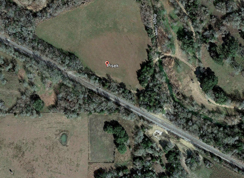
Where Was Boggy Tank? 29 55 N, 96 35 W
Right:
Referring to Boggy Creek, the Handbook of
Texas says...
"Boggy Tank was a swampy area that gave
the creek its current name. The railroad built a turntable there
to reverse trains for the run back up the track. The town of Pisek ...
moved one mile to the tracks. The railroad called the site Sandy Point,
but the name Pisek stuck. By 1896 the community became a shipping center
and had a post office and saloon..."
The Post Office closed in 1907. Since the turntable has been gone
for more than a century, it is not surprising that no visual evidence of
it is found on current satellite imagery.
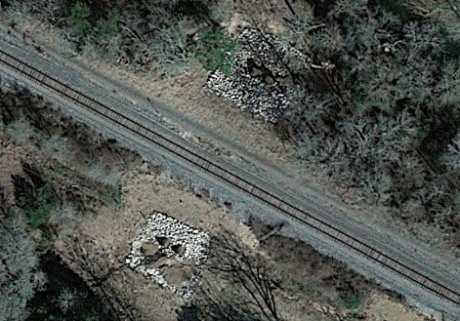
Nearby, however, is something
curious ...(above)
which appeared on both sides of the tracks in recent years. (Google Earth, January, 2022) |
 |
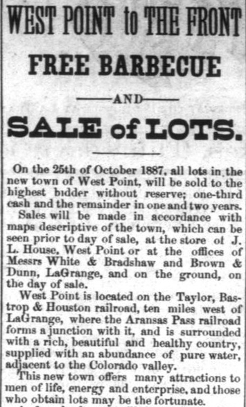 |
Left:
The La Grange Journal
of October 6, 1887
carried this advertisement (listed in its "New Ads" column) announcing
that all lots in West Point would be sold on October 25th to the highest bidder.
And who among Texans can resist free barbecue?
Although West Point had existed as a community since 1840, it was merely a rural
outpost with a handful of families at best. The arrival of the railroads in 1887
brought big changes. According to the La Grange
Journal, TB&H trains began operating through West Point in October.
The San Antonio & Aransas Pass (SA&AP) Railway was building
north
toward Waco on a surveyed route that would also pass
through West Point. Its trains were anticipated to reach town by
November 25th, but the precise date of the first train into
West Point for neither railroad has been determined.
The arrival of two railroads into West Point in the span of a month or two spurred
local real
estate promoters into action. The ad uses the present tense to assert that the "...Aransas Pass forms a
junction..." with the TB&H. This may imply that SA&AP work trains
had reached West Point by early October, but even if the rails were
still on the outskirts of town, it was rather amazing progress. The
SA&AP had completed its
original main line between San Antonio and
Corpus Christi only a year earlier before promptly
embarking on a massive construction program in 1887. One of the new
tracks
branched off the SA&AP main line at Kenedy and had been completed as far as Wallis, heading for Houston. A branch
from the Wallis line at
Yoakum was the one that went north through West Point, eventually to
reach Waco.
The SA&AP's northward construction
stopped at West Point while a bridge over the Colorado River north of town was
contemplated. The bridge opened in 1889 and the line was extended north
to Lexington that year. A track segment from Waco south to Lott was also
completed in 1889. The SA&AP's receivership commenced in the summer of 1890,
but the final 58-mile segment between Lexington and Lott was completed
in 1891 during the bankruptcy. |
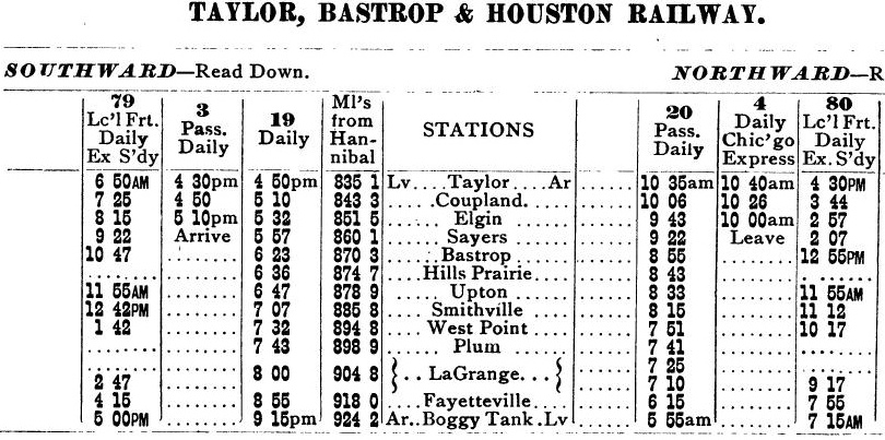
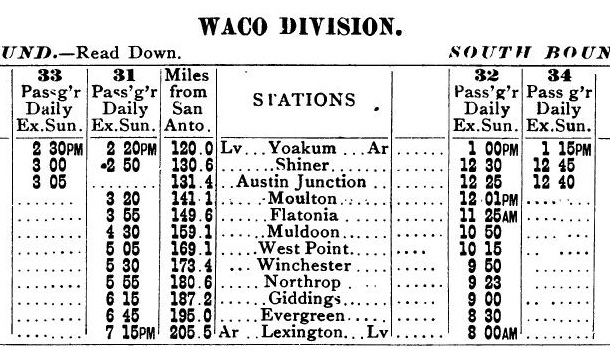
Above:
A marketing pamplet,
The Texas Spring Palace, was published in 1890 to proclaim the virtues of Texas living,
and it included a set of railroad timetables
for the entire state. These two showed the scheduled passenger service
through West Point for the TB&H (left) and
the SA&AP (right).
As of 1890, the TB&H terminated at Boggy Tank and the SA&AP terminated at Lexington. Note that the TB&H table includes a
"Miles from Hannibal" column. Hannibal was an important Missouri junction in Gould's MP
network.
For safety purposes, the Railroad Commission of Texas
(RCT) began regulating crossings of two or more railroads, both "at grade" and
"grade-separated", under new authority granted by the Texas Legislature in 1901.
Grade-separated crossings presented few safety issues, but RCT had the authority
to resolve disputes between railroads over whether a crossing should be at grade
or grade-separated (as it did in one
notable case in El Paso.) Under its new authority, RCT
released an order dated November 8, 1901 that mandated the installation of swing
gates at all railroad diamonds, pending further orders to install interlocking
plants. The presence of a gate did not affect the state law that required all
trains to stop at a non-interlocked diamond before proceeding. Thus, gates
accomplished little beyond displaying a STOP sign (in the middle of the gate)
positioned against one track.
Eventually, trains were authorized to approach gated crossings at restricted
speed, slow enough to come to a complete stop if the gate was closed but
otherwise permitted to continue across the diamond.
The Katy /
SA&AP crossing at West Point was likely gated relatively soon after RCT's
1901 order was issued. It was not, however, prioritized for an
interlocker. RCT wanted to "spread out" the timing of interlocking tower
projects so its limited engineering staff could take the time to review and
approve each plan prior to construction. The staff also had to inspect and
approve each installation prior to authorizing it to become operational. Under
its own priority determinations, RCT issued orders for railroads to interlock
specific crossings, but railroads could also solicit RCT's permission to begin
designing an interlocking system for any particular location. No evidence has
been found to indicate that the railroads requested RCT permission for an
interlocker at West Point, nor was there a good reason
why West Point should be prioritized. The crossing was near the town's depots,
hence most trains were stopping anyway. Moving slowly in or out of a depot meant
that an additional brief stop at the crossing created relatively little penalty,
i.e. there was no significant delay and only a limited loss of momentum.
Preserving momentum was a key benefit of interlockers. Slowing a train from
track speed down to zero and then reaccelerating to track speed cost significant
fuel and water for steam locomotives, and added delays. At interlocked
crossings, this was an avoidable penalty in the vast majority of cases since the
diamond was usually unoccupied.
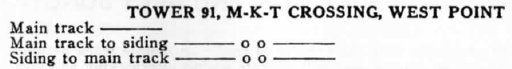
Right:
The January, 1913 issue of The Signal Engineer
identified West Point as a location for a planned interlocker
installation by the Katy. No order from RCT mandating a West Point
interlocker has been found, so this may have resulted from a request to
RCT by the railroads based on current
traffic levels. The plan was executed and RCT's published table of active
interlockers dated October 31, 1913 showed that Tower 91 at West Point
had been commissioned for operation twelve days earlier.
As the article projected, Tower 91 had a 12-function mechanical
plant, a basic design for a crossing of two railroads consisting of a
home signal, distant signal and derail in each of the four directions.
It was undoubtedly a two-story tower, but no photos have been found.
The article attributed the plan to the Katy, so it is unsurprising that
RCT records show the tower staffed and maintained by Katy personnel.
Under RCT's rules, the capital outlay for the tower and its interlocking
system would have been shared equally by the two railroads because the
crossing existed prior to the 1901 law. Recurring staffing, utilities
and maintenance expenses would have been split evenly between the two
railroads because they each used
half of the interlocker functions. |
 |
 |
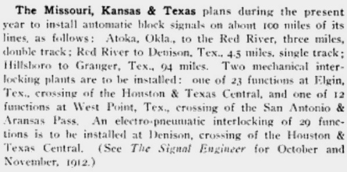
Left:
area map (not all railroads shown)
The installation of the interlocker at West Point seems to have been well-timed. Traffic
across the diamond increased substantially a little over a year later when
Southern
Pacific (SP) opened the Dalsa Cutoff between Giddings and
Hearne. SP owned the H&TC which went north to
Dallas and Denison, and it owned the Galveston, Harrisburg & San Antonio (GH&SA) Railway
which went west to San Antonio,
El Paso and the west coast. SP
traffic between points west on the GH&SA and points north on the H&TC had to
pass through Houston, incurring
significant delays due to track congestion. In 1915, SP opened the Dalsa Cutoff
and negotiated
trackage rights on the SA&AP
between Giddings and Flatonia. SP trains
from the west could turn north at Flatonia and take the Cutoff
at Giddings to proceed to Dallas via Hearne. The new
route was shorter and faster between Dallas and San Antonio (hence, the "Dal-SA"
name) because it bypassed Houston. Work on the Cutoff commenced in 1914
and it opened in March, 1915. Whether a
new tower at West Point had been part of SP's original plan for the
Cutoff has not been determined.
Below:
The San Antonio Express of Thursday, March 4,
1915 carried this news item reporting that the first train to operate over the Dalsa
Cutoff had run the prior Sunday, which was February 28, 1915.
 |
SP's close association with the SA&AP dated back to
1892. To help the SA&AP exit receivership, SP had offered to back SA&AP construction
bonds for any new lines it built. SP was prevented from buying the SA&AP by
state railroad competition laws, but it wanted the railroad to be successful
because its south Texas track network was complementary to SP's and there was
anticipation of significant interchange traffic. The bankruptcy court
approved the offer, and it worked well for both railroads until RCT began an
investigation in the spring of 1903. RCT believed that SP illegally held a
controlling interest in SA&AP stock, and they were able to prove it. SP
admitted malfeasance and RCT imposed a penalty that ordered cancelation of all
SA&AP stock held by SP, a loss of roughly four million dollars. More
than two decades later, SP was finally able to buy the SA&AP in 1925 by seeking
approval from the Interstate Commerce Commission (ICC.) Authority granted to ICC
in the Transportation Act of 1920 preempted RCT's authority in railroad mergers and acquisitions,
regardless of Texas law. In 1934, SP
consolidated most of its Texas and Louisiana railroads, including the SA&AP,
into a single operating entity, the Texas & New Orleans (T&NO) Railroad. At that
point, the SA&AP corporation ceased to exist and ownership of its lines was transferred
to the T&NO.
 |
Left: A 1940
T&NO employee timetable shows Tower 91 with "Continuous" staffing.
It has these whistle codes for trains to signal the tower
operator to line signals and switches for specific movements. RCT's
final comprehensive interlocker report published at the end of 1930
listed Tower 91 with twenty functions. The increase from the
original dozen was associated with signals, derails and switches
for sidings and connecting tracks. |

Above Left: With
North to the right, this West Point track chart dated
December 12, 1924 (Stuart Schroeder collection) shows connecting tracks in both of the eastern quadrants of
the diamond. The rectangle immediately northeast of the diamond is labeled "Intlr.
Tower" (presumably "Interlocker Tower".)
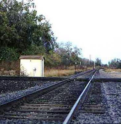
Above Right: This photo (Jim
King, c.1999) facing east along the former Katy tracks shows the equipment cabin
that housed the automatic interlocking plant at West Point after the Tower 91
manned structure was retired. The cabin is sitting trackside in the northeast
quadrant of the crossing where the tower once stood. The date of the tower's
retirement is undetermined. By 1959 (per a T&NO employee timetable)
the
crossing had been converted to an automatic interlocking.
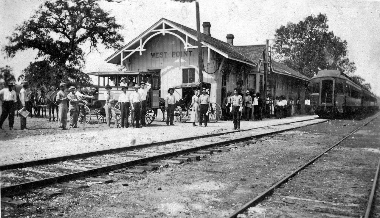
Above: This undated photo
(Chino Chapa collection) shows a passenger train at the Katy depot in West Point. The view is
to the west and the train is headed for Smithville. Bruce Blalock notes that
"...there are teams and buggies but no automobiles, so I'm thinking this would
be around 1900." A smaller Katy depot that presumably replaced this one is
reported to have been relocated to the Smithville Railroad Park, refurbished and
relabeled as Smithville's Katy depot.
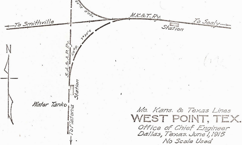
Right: This 1915 track chart (Ed
Chambers collection) shows the relative locations of the two stations at West
Point, and indicates that the connecting tracks present in the 1924
track chart were already in place by 1915.
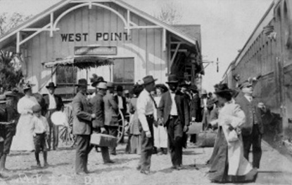
Below: undated photo of the Katy depot (William Wessels collection)
During World War I when railroads were governed by the U. S.
Railroad Administration (USRA), the two railroads at West Point applied
to RCT for permission to build a joint station, noting that the USRA
district director concurred with their request. RCT granted the
application, but no evidence has surfaced to indicate that a Union
Station at West Point was actually built. |
 |
Union Pacific (UP) acquired MP in 1982, but MP
continued to operate under its own name. UP then acquired the Katy in 1988 and
merged it into MP, reuniting the railroads a century after MP's lease of the
Katy had been broken by Texas courts. In 1996, UP acquired and merged SP, and the
following year, MP became fully merged into UP. As a result, both
tracks at West Point are now owned and operated by UP. The former Katy
line remains active in both directions, although it no longer continues all the
way to Houston, terminating 22 miles east of Sealy in the town of Katy. The Dalsa Cutoff
remains very active through West Point, but the former SA&AP tracks north of Giddings
(to Cameron and Waco) were mostly abandoned in 1959
except for a lengthy track segment north from Cameron that became an industrial spur.
South of West Point, the former SA&AP tracks remain operational through
Flatonia all the way to the
original branch point at Yoakum.
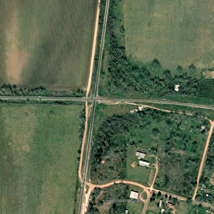
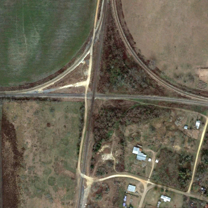
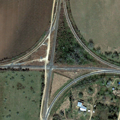
Above: The
presence of connecting tracks at West Point has changed considerably in recent
years, no doubt a manifestation of UP's ownership of both main lines. These Google Earth
satellite images (left to right,
2001, 2018 and 2022) show the gradual addition of connectors in three of the
four quadrants. The 2001 image shows that by then, the previous connecting
tracks depicted on the early track charts had been removed long enough to give
very little evidence that they had ever existed. Historic aerial imagery
suggests that those tracks had been removed by 1974 and likely earlier.
New connectors in the two north quadrants were in place by 2018, and a connector
in the southeast quadrant was added between 2018 and 2022.
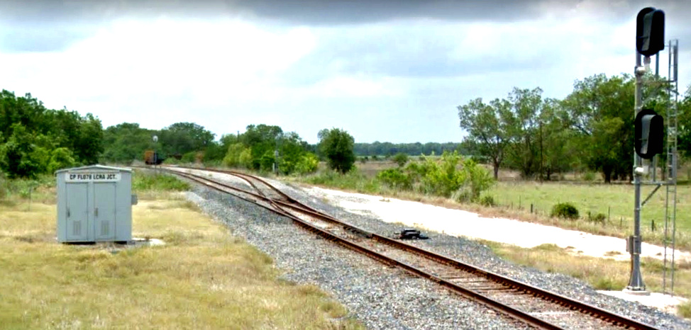
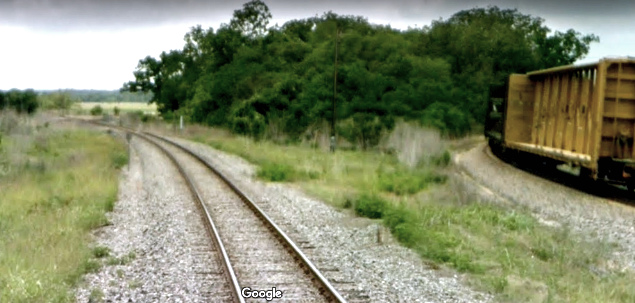
Below Left: These Google Street View
images from May, 2011 show rail cars on the northeast quadrant connector, which
obviously dated back to at least that year. The
sign on the equipment cabin identifies the connector as "LCRA Jct", suggesting that
the movement of coal trains to and from the Lower
Colorado River Authority (LCRA) coal-fired power plant seven miles east
of La Grange was the impetus for building it. Below Right: In
this closer view of the railcars, the West Point crossing diamond is barely
visible in the distance.